Showing posts with label Montana. Show all posts

Friday, October 25, 2024

2021-08-14: Camped in Bridger, Montana and Exploring the Pryor Mountains in Custer National Forest

Welcome back to AwayWeGo's Traveling Adventures. We've got the motorhome in the small town of Bridger, Montana. It's just up the road from the Pryor Mountains where my next job assignment is located. With my coworker being delayed in getting here, and he's bringing all the survey equipment, I have a free week or so to go exploring and geocaching. Today I'll show you some Bridger history. I also take a drive down to the jobsite at Pryor Mountain to do some Jeep off-road trail exploration. So hop in and let's go for a ride.


Bridger started out as a mile long alley of hastily built wooden shacks and businesses called Stringtown. They didn't have indoor water, no electricity, not even a wooden plank sidewalk to keep from walking through the wet mud or dry dust. But hundreds of people came for an opportunity to work in the coal mines or a job on the railroad. Calamity Jane even lived here in the early days of Stringtown, taking in laundry to earn a living.

Jim Bridger, born in Virginia in 1804, arrived in Montana in 1822 as a member of the Rocky Mountain Fur Company brigade. He roamed all throughout the Rocky Mountain region, trapping and exploring. A keen observer, a natural geographer and with years of experience amongst the Indians, he became invaluable as a guide and scout for wagon trains and Federal Troops following the opening of the Oregon Trail. He spoke several Native American languages, as well as being able to converse in French and Spanish, and was often called upon to negotiate disputes between the Native Americans and encroaching white settlers. In the 1860's Bridger moved down to Missouri and lived until his passing in 1881.


A post office was established on October 29, 1898. In 1902, Stringtown was renamed Bridger and incorporated in 1907. There are two geocaches in town. One at the Jim Bridger statue above (GCW1BR) and the other at the Veterans Memorial Park below (GC3NQEP).


From there I drove south on US-310 down to the town of Warren, and then north on the gravel Railroad Bed Rd up through the Pryor Mountain Wind Farm. Now I know where the jobsite is and how long it takes to get here.

Going past the wind farm, I continue on the gravel road up towards the mountains. The next geocache was at an old kiln site (GC6VTX9). This lime kiln was used by many of the early settlers of the nearby ghost town of the Bowler Flats area in the building of their homesteads from the 1890's to the 1930's. Not too far away on the other side of the hill was another geocache at a quarry site (GC7MF00).


Just past the quarry I come to a fork in the road. I can continue north on Railroad Grade Road or turn east onto Pryor Mountain Road, which has this sign. Well I think it's obvious which road I take the GeoJeep onto.


About a half mile down I spotted this mound with some rocks and a stick off to my right. My first thought was an old pioneer gravesite. Upon closer inspection and thought, it was more than likely a surveyors property corner. Probably set a hundred years ago.


I continued up the mountain on the way to a cave where the next geocache (GC7MF3E) was hidden.


The higher you go, the rougher it got. I don't make videos very often, but this time I remembered to give it a try.


I made it up to the cave. Unfortunately, I didn't find the geocache.


I wanted to continue going up the mountain and do some more exploring. But when you're out here all by yourself, miles from anywhere, it's getting late and you loose phone service, I can't take too much risk. So, back down the mountain...


Back down on the "Flats," I continue on to one more geocache (GC7MF44) before it's time to head back to civilization.


Taking a different route back out to US-310, I passed by this old homestead that made for a great photo.


To follow along on our travels and keep up with my latest blogs, you may do so here of course by clicking the "Follow" button to the right. And there's also my main website at AwayWeGo.US for the complete index of my traveling adventures going back to 2005. But also by using one or more of your favorite of these social media platforms: FacebookMeWeGabRedditTwitterGETTRInstagram, and TruthSocial. These all link directly to my profiles. Again, please feel free to comment and / or share.

Sunday, September 8, 2024

2021-08-11: Visiting Montana, Little Bighorn Battlefield, and Custer's Last Stand

Welcome back friends, RV'ers, Geocachers, Jeepers, and fellow travelers. When we last left you, we had just arrived to our next RV park in Bridger, Montana. The last time I was this far up in the northwest was way back in 2008 as a truck driver. While driving a big rig you don't get to see too much except out the windshield. This time we have the GeoJeep to get around and do some sightseeing. Today we start out at the historical Little Big Horn and Custer's Last Stand. So click and follow along as we tour these sacred grounds...


The Little Bighorn Battlefield National Monument Park (GC6F9E) covers an area of about 765 acres. It consists of the Battle of Little Bighorn that took place on June 25th & 26th, 1876 where Lt. Col. George Armstrong Custer and the 7th Calvary fell against the combined Cheyenne, Sioux and Arapaho force. It also includes the Custer National Cemetery and the battlefield site of the Reno-Benteen skirmish, about 3 miles southeast, with the Cheyenne-Arapaho warriors.


Following the fall of Custer and the 7th Calvary, the 11th Infantry led by Captain George K Sanderson buried Custer and his men on the battlefield where they fell. He also constructed the first monument on the site. From his official report dated April 7th, 1879 he wrote:

    "I accordingly built a mound out of cord wood filled in the center with all the horse bones I could find on the field. In the center of the mound I dug a grave and interred all the human bones that could be found, in all, parts of four or five different bodies. This grave was then built up with wood for four feet above ground. The mound is ten feet square and about eleven feet high; is built on the highest point immediately in rear of where Gen'l Custer's body was found."

In July of 1881, Lieutenant Charles F Roe and the 2nd Calvary built the granite memorial which still stands today on top of Last Stand Hill. About 220 soldiers remains were reinterred around the base of the new memorial, but left the markers in place where they had fallen.


In 1890, the stakes which marked where the soldiers had fallen were replaced with the marble markers you see today. Starting in 1999, the first of many red granite markers for the Cheyenne, Sioux and Arapaho Warriors were set in place where they fell.


To make it easier to spot for the hundreds of thousands of tourists who visit each year, Custer's marker was given a black background. Custer's remains had been reinterred to West Point long ago back in 1877, as well as many of the other officers remains were moved to Fort Leavenworth, Kansas or cemeteries across the country as requested by their families.


Custer National Cemetery was first designated as a U.S. National Cemetery on January 29, 1979 to protect the soldiers graves buried there. In December of 1886 it was re-designated as the National Cemetery of Custer's Battlefield Reservation to include soldiers graves of other wars. Eventually the name was shortened to Custer National Cemetery. Buried soldiers of the 7th Calvary, whos remains were discovered on the battlefield after the 1881 memorial was built, were reinterred here and listed as unknown.


The remains from 25 other cemeteries were transferred to here when frontier forts closed at the end of the Indian Wars. The fallen from many famous battles, Fetterman, Wagon Box, Hayfield, Big Hole and Bear Paw, now rest here.

Until reaching capacity in 1978, this cemetery accepted reservations for veterans and their spouses. There are soldiers here who fought in the Indian Wars, Spanish American War, World Wars I & II, Korea, and Vietnam.

There's a great book written by James Donovan that I highly recommend. "A Terrible Glory: Custer and the Little Bighorn: The Last Great Battle of the American West" is a great book put together from survivor accounts, official reports, and battlefield evidence. We listen to a lot of audio books while traveling down the road and this was one of our favorites. After listening to the Park Ranger give a summarized play-by-play of the battle, the welcome center recommended this book. We listened to it over the next couple of days as we drove around Montana.

After our visit to the battlefield site, we decided to go out geocaching and pickup some new Montana counties. The first one was also in Big Horn County in the town of Hardin. It was a travel bug hotel cache (GC4F5XD) located near the office to an RV park.

On the way to our next geocache, we crossed over into Yellowstone County. Along the side of Highway 47 was this old farmhouse that I just had to pull over and get a photo.


The geocache (GCKNZ4) was near a boat access ramp along the Big Horn River at I-94 and Highway 47. The geocache is called Manual Lisa. A little history lesson from the cache description:

    "Manual Lisa was a Cuban native. He lived 1772-1820. He was called Nebr, first white settler. He came up the Missouri in 1807 to start a fur trading venture. He built the 1st Fort Lisa on the Big Horn River. This fort was also called Manual Fort or Fort Manual. Unfortunately, he had to abandon the fort due to pressure from the British and the Indians. He was married to Mary Hampstead Keeney of St. Louis and they traveled between St. Louis and the Bighorn. She assisted the Yellowstone Expedition which had established its headquarters near the Lisa Trading Post. Manual Lisa saw himself as an Indian benefactor not an exploiter. He wrote to William Clark in 1817 (three years before he died) that he had distributed various seeds to help the Indians grow things. Some of these seeds were pumpkins, beans, turnips, and potatoes. He also loaned them traps and arranged for black smithing as needed.

    "There is a stone in this area (unfortunately they are on private land) where he carved his name M. Lisa-1807 and another stone with Colter 1810. They are somewhere around the mouth of the Bighorn. The Bighorn and the Yellowstone rivers flow together in this area. There are pictures of these stones at the cafe/casino in Custer, Mt. The pictures were taken in 1920 and you can clearly see the names. The Chamber of Commerce in Hardin, Mt. is trying to put more information together on historical sites in this area."

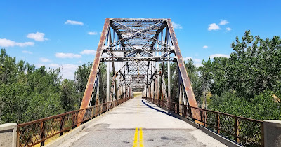
Well I didn't get to see the 200 year old names carved in the stone. But I did get a good view of the Big Horn River and an old bridge around the corner.


Going east on I-94, we cross over into Treasure County. Just off the Hysham exit is the Memorial Vale Cemetery and our next geocache (GC51TNW). There was a caretaker out there installing a new headstone. After watching for a few minutes, he didn't seem to care much about our activity. So I jumped out of the GeoJeep real quick, found the cache, signed to log, and went on our way.


And finally, the last geocache was further down I-94 into Rosebud County. Just a quick earthcache at a highway rest area (GC1GCXE). Now on back to the motorhome to end the day. Thanks for riding along. 

To follow along on our travels and keep up with my latest blogs, you may do so here of course by clicking the "Follow" button to the right. And there's also my main website at AwayWeGo.US for the complete index of my traveling adventures going back to 2005. But also by using one or more of your favorite of these social media platforms: FacebookMeWeGabRedditTwitterGETTRInstagram, and TruthSocial. These all link directly to my profiles. Again, please feel free to comment and / or share.

Sunday, August 18, 2024

2021-08-10: Geocaching Through Wyoming and Into Montana Reaching Our Destination

Well we woke up this morning at the Wyoming Welcome Center just south of Cheyenne. The goal for today is to reach our destination in Bridger, Montana. Hopefully along the way we'll have opportunities for some sightseeing and picking up new counties for our geocaching map. So click along and join us. What did we discover today?


So we set out from the Welcome Center and headed north up I-25. Just over an hour later, I exit into the Dyer Junction Rest Area located in Platte County. After finding the geocache (GC7FP6B) for the county, we read the many information boards and took some photos. To the east we got a distant view of Laramie Peak.


The next four paragraphs are from one of the Historical Information Boards:

    As you journey through Wyoming, you are one of the countless travelers who has looked out to the west and seen the granite rising of Laramie Peak. Near Scottsbluff, Nebraska, approximately 80 miles east of Dyer Junction, emigrants witnessed their first view of the western mountains with the hazy silhouette of Laramie Peak. Although the sight may have been awe-inspiring for the emigrants traveling on the Oregon and Mormon Trails, it also indicated the start of their journey into the mountains ~ a much more treacherous expedition than that across the plains.

    In their diaries, emigrants and other travelers usually noted seeing Laramie Peak. In Chapter IX of his 1891 Roughing It, Mark Twain wrote, "We passed Fort Laramie in the night, and on the seventh morning out we found ourselves in the Black Hills, with Laramie Peak at our elbow (apparently) looming vast and solitary ~ a deep, dark, rich indigo blue in hue, so portentously did the old colossus frown under his beetling brows of storm-cloud. He was thirty or forty miles away, in reality, but he only seemed removed a little beyond the low ridge to our right."

    Laramie Peak, which stands at 10,272 feet above sea level, is the highest Wyoming point in the Laramie Range. Part of the central Rocky Mountains, the Laramie Range, originally called the Black Hills, reaches for 125 miles from the Colorado-Wyoming border to the North Platte River near Casper.

    Visible from over 100 miles away, Laramie Peak is named for the early French trapper, Jacques La Ramie. While on a beaver trapping expedition, La Ramie vanished from what is now the Laramie River. Upon learning of his disappearance, other trappers in the region named the river after him. Soon the nearby mountains, plains, and many other areas also took the name.

Driving further up into Converse County, we stopped at the Orin Junction Rest Area for another geocache (GC33N3D).

Just east of Casper, Wyoming was a T/A Truck Stop. There we fueled up and found another geocache for Natrona County (GC5CHCQ).

Still headed north on I-25, we stop at the Kaycee Rest Area for a geocache in Johnson County (GC8BC7Z).

Now driving on I-90, we make one last stop at the Wyoming Information Rest Stop in Sheridan County for our final geocache of the day (GC97JGC).

We finally crossed over into Montana via I-90 up through Billings. We don't have much further to go, therefore I skip geocaching counties because it would be much easier in the GeoJeep vs the big motorhome. So it's I-90 to Laurel, then turn south on US-212. At Rockvale, turning south on US-310 a few more miles and arrive in the town of Bridger.

But just as we pull into town I noticed the RV's temperature gauge starting to climb. Luckily we're just 3 blocks from the City Park RV Park. I quickly pick a spot and park. Then I head to the bedroom and lift up the bed to get a good look at the top of the engine. Sure enough, another freeze plug on the side of the head has sprung a leak! That makes the third one!


OK, so there's only two auto repair shops in town. One is practically right across the street. I go there first. Nope, they only work on cars plus they're booked solid. So then I drive around the corner to Carbon Equipment Repair. Yes, they do work on diesel, big rigs, and farm equipment. But they too are booked out for a month. And we're only here for two weeks. I say we can't go anywhere and we're pretty much at their mercy. Nothing to do now but to wait and see.

In the meantime, I'm still waiting for the other surveyor to show up. So that means a free week. Sounds to me like a geocaching road trip around Montana might be in the making. I hope to see you back again soon.

To follow along on our travels and keep up with my latest blogs, you may do so here of course by clicking the "Follow" button to the right. And there's also my main website at AwayWeGo.US for the complete index of my traveling adventures going back to 2005. But also by using one or more of your favorite of these social media platforms: FacebookMeWeGabRedditTwitterGETTRInstagram, and TruthSocial. These all link directly to my profiles. Again, please feel free to comment and / or share.