Showing posts with label Jeep. Show all posts

Saturday, October 9, 2021

2020-04-05: Geocaching Counties Around Georgia and Finding a Covered Bridge, an Old Jeep, Cemeteries and More

Welcome back to the AwayWeGo Geocaching Adventures blog. Our job has us traveling all across the country. We prefer the rural backroad and byways when driving from jobsite to jobsite because they have the most interesting places. We find most of these historic and roadside attractions because of geocaching, but then there are often a lot of unexpected surprises too.

In today's edition, we've been in Georgia working for a week now and it's our first day off. So of course it's time for a mini-roadtrip around the backroads of Georgia to add some new counties to the geocaching map. So hop on in the GeoJeep and let's go see what we can find!


A short drive down the road on the way to our first geocache, I pass by this house with some old rusty farm equipment off to the side. But what caught my eye the most was the old rusty Jeep. Along with the trucks back within the trees, it's kinda sad that they're just abandoned and left to rust and rot away.


Now in Webster County, it was a quick roadside geocache stop for the county (GC1W1MN).

Driving north on Georgia Hwy 41, we arrived in Marion County. Right at the county line is what remains of the ghost town community of Church Hill (GC71HPY). As early as 1812, Methodist missionaries came into this area and found the Indians to be receptive to the Gospel, so missions were established to teach and minister to the Indians. Following these missionaries came large numbers of immigrants from the eastern United States and from North and South Carolina. The mission points were established along trading paths which developed into the "Old Salt Trail" and later St Mary's Road from Columbus to the coast.


Here near three crossroads, a large church community developed. Five churches soon sprung up in this community originally known as Searsville. After the Baptist, Methodist, Presbyterian, Bible Baptist, and Christian Church's were established the area was more commonly known as Church Hill. The Shiloh-Marion Missionary Baptist Church is the only remaining church of the five. What began as a Baptist Missions Point in 1812, became Shiloh Baptist Church in 1835 with 8 members. At its peak it grew to 150 members. Presently there are about 12. A time capsule was placed back in 1995 to be opened in 2045. (For a full recount of the history of Church Hill with photos and more, visit https://ursa.mercer.edu/handle/10898/12398)


Across the street is the Shiloh Baptist Church Cemetery. Many of the communities early pioneers and Civil War veterans are buried here. There are also some smaller cemeteries nearby and all that remain of the other churches. Among the cemeteries are segregated sections, one for slaves and another for Native Americans.


Also in Marion County and further north in the town of Buena Vista, we stopped for another geocache behind the historic old Gypsy Camp Grist Mill (GC71K1Q). There were a LOT of logs out behind the building and I spent a LOT of time looking at all the possible hiding places. But I wasn't able to find the cache and had to DNF it. But I did learn some history.

The Gypsy Camp Grist Mill was moved from its original location to its current site on the Murray Estate in 1930. At the time, the mill was a key agricultural asset to the community. It used electricity to power a network of chutes and belts woven through the three-story building to grind corn into meal. It operated for thirty years, closing in the early 1960's. Gypsy Camp Grist Mill got its name from a nearby campground and store where for a few weeks every winter ‘gypsies’ made their home, purchased supplies, and traded. The gypsies were believed to be of Serbian and Russian decent and migrated to the United States during the 1850's.


Crossing the line into Talbot County, I make a quick stop to find a geocache in an old pay phone (GC51AA7). Then at the top of the county there was another geocache at this historical marker (GC3XR5X). A large memorial which reads: "In Honor of Our Confederate Heroes, Sons of Confederate Veterans 1896, Echols Guards Camp #1711 S.C.V., 2005"


Next up in Meriwether County, in the town of Manchester, is this train car and my next geocache (GC70TEH). It's called Elliott Station as a memorial for Tyron Elliott, a prominent member of the community.


The next two geocaches were at the Red Oak Creek Covered Bridge (GC2885, GC6QDNP). Also located in Meriwether County, this bridge was built in the 1840's by freed slave and noted bridge builder Horace King (1807 - 1885). Constructed on the town lattice design, the bridge's web of planks crisscrossing at 45- to 60-degree angles are fastened at each intersection with a total of approximately 2,500 wooden pegs, or trunnels. Although King is credited with the construction of many covered bridges throughout West Georgia, this is his only surviving bridge of this design. At 391 feet, including the approaches, this structure is the oldest and longest wooden covered bridge in Georgia. And you can still drive across it!


If you look carefully down the side of the covered bridge you will notice a change in the wood forming a line about 2/3 of the way up the side. On July 7, 1994, the river flooded over and rose up to that height.


Now in Coweta County in the town of Senoia, there's another bridge. This town in Georgia is often used in filming the TV show "The Walking Dead." In The Walking Dead, this old bridge, which crosses over railroad tracks, is in the fictional town of "Woodbury" in the TV show. While I didn't find the geocache (GC86RNR) on the bridge, I still like finding old bridges.


Here's the GeoJeep in downtown Senoia. You might recognize this street scene and a gazebo where a virtual geocache (GC89183) is located in other films such as "Driving Miss Daisy" and "Fried Green Tomatoes."


Crossing Line Creek into Fayette County, I stopped for a quick park & grab Challenge Cache (GC6JM2D). A Challenge Cache is usually a simple cache to find. However you have to meet certain achievements in order to log a find on it. This one requires you to have found 1000 geocaches before logging a "Found It." I passed that accomplishment a long time ago! And then there was the State Souvenir Challenge cache (GC7QN34) up the road. That one required you to find a least one cache in 10 different states. Yep, passed that one a long time ago too!

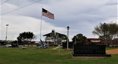
From there taking GA-34 over into Heard County and the town of Franklin, I make a quick find at the Veterans Memorial Park (GC69X5M).


Nearly 8 PM and heading south, I make one more stop as it's getting dark for a quick cache in Troup County (GC2D30C). We picked up nine new caching counties on this run today. Still a little more than 100 miles of driving to get back and I gotta work tomorrow, we drive straight there. Found a lot of history on our adventure today. I hope you have enjoyed the ride and come back soon. See you next time...

To follow along on our travels and keep up with my latest blogs, you may do so here of course. But also by using you favorite of these social media platforms: FacebookMeWeGabRedditParlorTwitter, and Instagram. These all link directly to my profile. Again, please feel free to comment and / or share.

Saturday, September 25, 2021

2020-03-29: Roadtrip Day 3: Driving Through Mississippi and Alabama on the way to Georgia

Welcome back to day #3 of our east coast roadtrip from Texas to Georgia. For today we travelled through Mississippi and Alabama. We gotta long day ahead with a lot of stops, history, cemeteries, counties, and geocaches. So let's get rolling... 


After checking out of the hotel and grabbing breakfast, we found a quick geocache (GC30XDE) right next door to start the day with a Leflore County find. The next three geocaches were quick roadside caches for Carroll County (GC4GX44, GCQ0DW). The last one (GC11P5Y) was down by this creek where supposedly a family of bobcats were living. I even brought my good camera with the zoom lens just in case, but didn't see anything.


Still traveling eastbound on US-82, we stopped at the Old Middleton Cemetery (GC5J1PN) for a Montgomery County geocache find. The Middleton Cemetery was established in 1833 and has 126 interments with the last being in 1910. Then the cemetery was abandoned and went unmaintained for nearly a century. Finally there was an interest in the cemetery once again and most of the headstones were found broken and scattered. In 1992, the Winona Lion's Club cleaned up the 2 1/2 acres, reassembled the broken pieces, and arranged them together as a memorial.


More quick roadside geocaches to pick up some new counties in Mississippi: Webster County (GC7BW83), Choctaw County (GC7BW7J, GC7BW7B), Oktibbeha County (GC3WMG1), Clay County (GC48PN6, GC2DQQ2, GC3D99T), and Lowndes County (GC3CG7V, GC7ER16).

Continuing east on US-82 and crossing over into Alabama, our next stop was the Funderburk Family Cemetery (GC1X277). Located along US-82 on the west side of a tiny community of Coal Fire in Pickens County. Originally called Fundee, it was the combination of two settling families; the Funderburks and the DeLoaches. The name was eventually changed to Coal Fire or sometimes called Cold Fire after a local creek. A post office was established in 1871 but closed in 1927. This small family cemetery was downhill closer to where US-82 is today. When the widening of the highway to 4-lanes began, the state moved the thirteen graves further up the hill into the woods as you can see from the photo below. The graves date from 1850 to 1898.


Guardian of the Cache


One more quick geocache on the other side of the Coal Fire Community (GCVMR1) and we continued down the road.

The next three geocaches were in the Corinth Church Cemetery in Tuscaloosa County (GC333MN, GC4AR5A, GC4AR4T). I found two of them but had to DNF on one. This cemetery has over 600 interments dating back to 1860. The one that caught my eye though was this more recent black headstone with the mural on it.


Our next stop was near downtown Tuscaloosa, Alabama at the site of the State Capital Ruins for a virtual cache (GC7B7T6). In 1825, the Alabama State Senate agreed to move the capitol from Cahaba to the thriving town of Tuscaloosa. The building was completed in 1829 and had this beautiful copper dome that could be seen by all the passing vessels down the Warrior River below. The building was fashioned in the Greek Revival, and the Federal styles of Washington D.C. and Thomas Jefferson. The building was used as the capitol until 1846.

It was at this time that the state capitol was moved to Montgomery, down where more commerce was being conducted along the Alabama River with the majority of the states population. Tuscaloosa lost over half its population after the capitol was moved. The building was then given to The University of Alabama who seldom used it so they leased it to the Baptist Convention who established the Alabama Central Female College. In 1923 it burned down and was suspect to faulty wiring as the cause.


On the parameter of the square now known as Capital Park, sites a few historical buildings. This first one is the Old Tavern. Built in 1827 three blocks east on Broad Street, it was also a stage stop and inn frequently used by political leaders while Tuscaloosa was still the state capital. It was moved here to Capital Park in 1966.


When Alabama became a state in 1819, Tuscaloosa also was incorporated as a town. The following year in 1820, the McGuire-Strickland House was built. The house stands to this day as the oldest wooden framed home in Tuscaloosa. Originally located at the corner of Greensboro Avenue and 15th Street, this home was built for the county’s first probate judge, Moses McGuire. The home later served as the manse or preacher’s home for the First Presbyterian Church from 1844 to 1866. The house was bought by the Strickland family in 1866 and remained in the family for over a century until 1969 when it was given to the newly formed Tuscaloosa County Preservation Society. Around 1970 the home was moved from its original location to Capitol Park where it is currently used as part of the Capitol School.


On the southeast side of Tuscaloosa is the Veterans Memorial Park and our next geocache (GC8BFBG). Some of the displays here include the Vought A-7E Corsair II, a 5 inch / 25 caliber "Dual Purpose" secondary artillery gun from the U.S.S. Tuscaloosa, a M60A3 TTS Medium Tank, and a Bell UH-1 Iroquis (Huey) Helicopter. This memorial was built on the site of the Northington General Hospital, a U.S. Army hospital operating here during World War II.


But of course my favorite was the Willys Jeep decked out in Air Force colors. Here's my GeoJeep TB with Uncle Willy.


Leaving Tuscaloosa and getting back down US-82, our next stop was a quick parking lot find at a Walmart in Bibb County (GC1K0NY).

And finally, our last geocache of the day was an old virtual cache called Just Plain Spooky (GCB13A) located in Autauga County. All the locals who live in Prattville are aware of this display, but visitors do not know about. Mr. Rice started this display in 1987 and added more to his collection year round, until he passed away in 2003. He wanted to 'spread the word'. His collection has been documented in a book that they have at local bookstores around Prattville and Montgomery. The photo I took is just a small section of what is probably four times the length of the display.


Well that's another 300 miles behind us, another 23 caches and almost 12 hours later. Time to stretch out and relax a bit. And tomorrow we'll start all over again! See ya back here real soon...

To follow along on our travels and keep up with my latest blogs, you may do so here of course. But also by using you favorite of these social media platforms: FacebookMeWeGabRedditParlorTwitter, and Instagram. These all link directly to my profile. Again, please feel free to comment and / or share.

Monday, March 16, 2020

2018-05-12: Making The Deal For A New GeoJeep

Hey welcome back to the AwayWeGo Geocaching Adventures Blog. If you remember from last week, at the end of the day my GeoPrius blew the engine. So throughout this past week, I contacted four Jeep dealerships to start working on a replacement geomobile.

The first and closest dealer was right there in Fort Stockton, Texas, Ram Country Fort Stockton. They actually had exactly what I was looking for! A new white 2018 Jeep Wrangler JK 4-door Rubicon, fully loaded with navigation, heated seats, trailer hitch, remote start, and much more. Sadly though the only thing the salesman was interested in was getting me down there for a test drive.

Hello! I don't need to test drive it. It's a Jeep Wrangler, it's gonna have a rough ride, a lot of wind noise, and bad gas mileage. "What's your BEST selling price?" Salesman: "I'm sure we can get you the best price possible. How soon can you come down to discuss putting you in your new Jeep?" That's all he would say. He wouldn't give me any numbers. I don't have the time nor do I want to sit there in your dealership for hours on end to negotiate a deal. So I gave them a bad review on Google.

Next I called the Jeep dealer in Odessa, All American Chrysler Jeep Dodge, and got a hold of a sales guy willing to work with me over the phone. They had one there with everything I wanted just like Fort Stockton except it was bright red. Now if I were buying another Corvette, that would be perfect. But every other vehicle I prefer to have in white. It was still tempting.

This guy was working hard for me though. He even called Fort Stockton to see if they could make the trade and then sell it to me, but they refused. There was also another Jeep he thought I would like that was a couple of years old. The couple that was wanting to trade it in also had a motorhome so the Jeep was already equipped with the tow brackets. But they couldn't take in the motorhome. So that couple ended up going back to the RV dealer who bought back the motorhome and the Jeep.

Even though I didn't buy a Jeep from them, I left them a good review anyway because they put in a good effort. They just didn't have the right inventory.

I also had a call into All American CJD in San Angelo. They had some possibilities but nothing really filling all the option requirements that I was looking for. So there too was an inventory problem.

Checking several other dealer websites as well but nobody had the right Jeep I was looking for.

Another call that I had made was to Freedom Jeep in Killeen, Texas. They had a 2018 Jeep Wrangler JK Sahara 2-door. I actually like the 2-doors better, but I knew the 4-door would be more practical. But this one had the navigation, XM radio, heated seats, the right colors and all. The only thing it didn't have already on it was the tow hitch.

And best of all they could work with me over the phone. Especially since I was over 300 miles away! We made an agreement on the price. But when it came to financing their interest rate was a bit high. They said they can work with outside sources, so I called my credit union back in Florida and got a rate less than half what the dealer quoted. After letting the dealer know, their finance manager called me back the next day and said they could do it for 0.2% higher than the credit union. I figured it was close enough and agreed to complete the transaction there to save time. By now it was Thursday and they would have to wait to release the Jeep until they received payment from my credit union.

After work Friday, I caught a ride home from a co-worker who also lives in Killeen.

This morning my wife dropped me off at Freedom Jeep and they had my Jeep parked right there by the showroom. They had all the paperwork ready to go. I could have signed the papers and been on my way in less than 30 minutes. But remember it didn't have the trailer hitch option from the factory. So after I arrived they immediately sent it into the shop as I went into the finance office. They got a GREAT review on Google from me!

Now I have my new GeoJeep II. Now I just got to get some Travel Bug decals made for it.


The former GeoJeep I

So if you're ever in the market to buy a new/used car, there's a couple of things to remember as a buyer:

1) Research! Know what kind of car you want BEFORE you talk to the dealer. If you want a test drive, rent the car you're thinking about. You'll get a better idea if you like it or not versus driving it around the block.

2) Shop Online! Don't be constrained to the dealer nearest you. If you can get a better deal from a dealer over in the next town wouldn't it be worth it to take a longer drive? And don't worry about letting them know you're shopping around for the best deal.

3) Probably the most important thing of all: shop with your brain and NOT with your emotion! That's why the salesman want you there to drive, feel, and smell the car. They want you to fall in love with it and make it an emotional purchase. Then they have you hooked. But if you buy with your brain, you have the upper hand. And you have to be willing to walk away from the deal. Remember they want to sell you that vehicle. Work out the numbers and come up with an agreement before you even get there and you won't be wasting a whole day and into the night going back and forth.

Now to go places the GeoPrius couldn't get to!

Sunday, December 29, 2019

2018-03-25: Geocaching Through Ghost Towns, Old Schoolhouses, Cemeteries, a FTF and More!

So on today's 360+ mile drive from Killeen to West Texas, I visit a few cemeteries, a couple of ghost towns, two old school buildings, I spot an old Jeep rusting away, and I get a First-to-Find! So let's get started...


Driving westbound on US-190 into San Saba County, my first geocache was a quick roadside stop called "Me and My JJ" (GC28F72). Soon after that was a "Westbound Picnic Cache" (GC28RQF) at a roadside picnic area. Comanches used to use the hill location of the picnic area for smoke signals to communicate long distance in the pre-settlement times up until the 1870's.

Entering the town of San Sabo, I turn into the Mill Pond Park and head towards the "Armadillo Travel Bug Hotel" (GC6Y53J). A travel bug hotel is just a geocache big enough to hold travel bugs. Some cachers create very elaborate "hotels" that look like actual hotels inside which are really cool. This particular one was just a larger sized container. Oh, and for those new to geocaching, a travel bug is an item with a trackable number on it. The purpose is to retrieve and place from cache to cache so the sender can follow its travels.

My next geocache is located on the north side of town in the San Saba Cemetery and is called "Edge of Eternity" (GC7284N). From the historical marker: San Saba Cemetery, previously the Odd Fellows Cemetery, is located on 17 acres of land about 800 yards north of old town San Saba. On April 18, 1883, the San Saba Chapter of the Independent Order of Odd Fellows (IOOF) purchased 10 acres of this land from JJ Stockbridge to establish a cemetery, which they maintained for 45 years. On April 3, 1929, the newly incorporated San Saba Cemetery Association purchased the cemetery for $1.00 and an additional 7 acres from Mrs. May Holman also for $1.00. In 1935 burials from San Saba's earliest city cemetery, now Rogan Field, were reinterred here. The cemetery reflects San Saba's earliest times and is a continuing record of the lives and culture of its changing people. (2008)


Continuing westbound on US-190, I entered the town of Richland Springs. Jackson J. Brown and his family settled near the springs on Richland Creek in December 1854. The Brown School was constructed in 1868 and named for the neighborhood's original settler. The area attracted settlers through the 1870's, and in 1877 a Richland Springs post office opened in the store of Samuel E. Hays. By 1890 local production of cotton, grains, and livestock supported a settlement of 150 residents, including a justice of the peace precinct, a constabulary, and several commercial and craft businesses. A local newspaper, the Eye-Witness, began publication in 1905. Not long after, the First State Bank was organized, and in 1911 completion of a trunk line for the Gulf, Colorado and Santa Fe Railway linked the town with the main line between Galveston and Amarillo. Richland Springs incorporated in 1932. With a population nearing 500 and as many as forty businesses, the town prospered until the onset of the Great Depression. A three-year drought in the mid-1950's crippled the local economy again. The town's only bank failed, and within a decade its residential and business populations had fallen by nearly half.

Anna B. Davenport (9/18/1882 -- 11/24/1882), was the first person buried here at the Richland Springs Cemetery. To help you find her gravesite look for a historical marker by her headstone. There are over 2200 internments here. And there was one that kinda stood out from the rest and the reason I placed the geocache there (GC7M2M5). John Henry Hart (1873-1946) and his wife Katy Abbie Hart (1877-1956) have a rather unique border surrounding their family plots. And I just happened to have a container that blends in perfectly.


The next little town down the road was Rochelle. Even though there wasn't a cache here, I stopped by the cemetery anyway. From the Historical Marker: E. E. Willoughby (1853-1935), a cattleman from Tarrant County, moved to Rochelle (then about 1.5 miles SE) in 1883. He acquired land here in 1886 along the Brady-San Saba Road. In 1889 he donated two acres near this site for the community's school and church building, moved here from its original 1886 site about 1 mile south. When Willoughby's 19-month old son Ernest Eckie died in 1894, he buried the infant near the school. In 1896, Willoughby deeded one acre here as the cemetery. A new school was built here in 1899.

The community and schoolhouse were moved in 1903 about 2 miles northwest to the new Fort Worth & Rio Grande Railroad. This cemetery continued to serve the new community, first named Crothers but soon renamed Rochelle. The tombstones here of Rev. and Mrs C. W. Jones indicate that she died in Crothers (1906) and he died in Rochelle (1910), though they both died at their home in the same town. Willoughby deeded another acre to this cemetery in 1910, but he was ultimately buried in Brady at Live Oak Cemetery. The rock fence here was built in 1935, and four more acres were purchased in 1943. The cemetery contains almost 500 graves, of which 105 are unmarked. An association founded in 1972 cares for the grounds.


Continuing west on US-87 closer to San Angelo, I come to the ghost town of Vick, TX (GC18HAF). Vick is at the junction of Farm Road 381 and U.S. Highway 87, four miles south of Eola in west central Concho County. In 1963 the community had a post office, a motel, and two other businesses. A 1984 map showed a cluster of buildings at the site. In 2000 the population was twenty. Now only a few homes remain and the ruins of numerous buildings. The old gas station has been turned into a private home.

Driving a few miles north to Eola was my next geocaches. The community has had a post office since 1901, when it was known as Jordan. In 1902 the name was changed to Eola, reportedly after a small local creek named for Aeolus, Greek god of the winds. In the middle to late 1890's public school lands in the county were put up for sale at fifty cents an acre. Spurred on by railroad promotion, a land boom resulted in the area of Lipan Flat, a section that stretched east from San Angelo to the Colorado River. Eola was one of the communities created during this boom, which included many immigrants from central and eastern Europe. In 1920 more than 100 people in the vicinity of Eola were reported to be of Czech descent. The first family to settle in the area was that of Asher L. and Lizzie Leona (Hollman) Lollar, who established themselves at a site 3½ miles southeast of Eola in 1898. Both Asher and Lizzie are buried in the Eola Cemetery (GC18H8M).

Scrolling through the Find-A-Grave website to see what the oldest grave may be at the cemetery, I found something odd. There was a listing for a Lydia Lillath White 1806-1807, long before the Lollars arrived. Looking closely at the headstone, it looks like the engraver flipped the number "9" around for the day and year. That confused the person entering it into the website. But based on the history of the community and the other graves listed, I'd say the first buried there in the cemetery was M M Schooler in 1902.


By 1902, when the first local store was built, the community numbered four families. Within the next two years a Baptist church was erected. The first school was conducted in a church on the Will Stephenson ranch. A two-story, two-room schoolhouse was built in 1906. In 1908 the community had a windmill and an Odd Fellows lodge. By 1914 Eola had a drugstore, a general store, and a population of twenty-five. In 1940 the community had a population of 250. A nine-teacher school taught elementary and high school classes. The school has long been closed. There is a geocache there though (GC11BBQ). According to the TexasEscapes website, the school building has been purchased and the new owner is slowly restoring it. The original school is the white building and now contains a restaurant and micro-brewery. The brick section was added in the 1930's along with the gym which is on the backside. You can see the domed top sticking up from behind.


Between Eola and San Angelo I arrive at another old schoolhouse and my next geocache (GC1CHVX). The cache page or any research I've done in preparing for this blog has given me any information on this old school. Some of the possibilities is that the town of Wall, TX, a few miles to the south, used to be called "Lipan School" and then "Little School." Perhaps from that pre-1906 era?


Having passed through San Angelo and still on US-87, I arrived in Sterling City. I remembered a new geocache published there a few days earlier and had yet to be found. So I dropped down Hwy 163 for "overlooking Sterling City" (GC7KR29) to find a nice blank logsheet! WOHOO!! Always good to get those First-to-Finds!

Down the road in Garden City I found a few more caches. The first one wasn't all that exciting except for the finding another cache is always a good thing. But what I found next to it was more interesting. The "Butane4Life" (GC3AJ2N) geocache is a quick roadside cache hidden near a huge butane storage container. But off to the side of where it sits are some old abandoned tanks and other equipment. And then there this old Jeep just rusting away. Oh if I only had the time and money to do something with it, I'd be tracking down the owner to see if they'd sell it!


After a quick stop by the Glasscock County Courthouse cache (GC17W82), I proceeded south of town to the "Graves Graves" cache (GC1PEVW) at the Garden City Cemetery. From the historical marker: The Garden City community has been using this burial ground as early as 1886. That year, a child of county commissioner Sullivan Hill and his wife, Lucy, was buried here. Four years later, a sibling was buried at the same spot; the two graves share a single stone.

The Hill family plot, where Sullivan and Lucy are also buried, is one of many in the cemetery representing the early area settlers. Other early family names found throughout the burial ground are Hanson, Gooch, and Cox. Family plots are typically bordered by concrete curbing. Most gravestones are vertical, especially in the older section of the cemetery, which is indicated by the remaining decorative iron fencing. Some of the individual family plots also include original fencing.

In 1914, John Etheridge and Perneice Gore Lawler formally designated the originated one acre tract as a cemetery. Today, the county maintains the burial ground, to which three acres were later added. As the final resting place of many of the early settlers and their descendants, the cemetery is a significant link to community's history.


Already late in the afternoon, I had to get moving. I've still got an hour and a half drive ahead of me AND also need to stop by Walmart and get some groceries. So that's it for now. I hope you enjoyed todays adventure and learned some history. See you next week for more.

Sunday, September 29, 2019

2017-11-04: Geocaching Cemeteries, Ghost Town, and the Texas State Capital

Welcome back! Today's adventure brought us down to the Austin, Texas area where my wife had a business seminar to attend. So while she spent the day in meetings, I used that time to explore some rural areas around Austin. Then after rescuing her after the meetings were over, we took a tour of the capital building in Austin. Let's get started...

After dropping her off, I headed south on I-35 out of Austin to just past San Marcos. Exiting the highway to get to a couple of small family cemeteries a block away, I was delayed by a long slow moving freight train. Looking at my c:geo live cache map, I noticed two caches located just in the shopping center to my right. Might as well make this delay useful! So I gave up my spot in line and grabbed caches GC1PX9A and GC33APV. By now the train had passed and I was able to continue on.

My first planned cache was at the Pitts Cemetery (GC2ZQ9Z). From the historical marker: John Drayton Pitts was born at sea on August 26, 1798. During the voyage of his parents John and Jane Pitts, from England to Charleston, South Carolina. They moved to Georgia during the war of 1812, and John D. married Eliza Permelia Daves in April 1819.

John D. Pitts was elected to the Georgia Legislature in 1841 but later moved to Grimes County, TX. He persuaded his extended family in Georgia to join him, and in 1843 eleven Pitts families moved to Texas.

John D. Pitts served as Adjutant General under Texas Governor George Wood from 1848 to 1849. Pitts bought land here from his friend General Edward Burleson in 1850. And eventually much of his extended family settled along the San Antonio - San Marcos stage route in a community called Stringtown.

Pitts Cemetery began in 1850 with the burial of John Malone, infant son of James L. and Eliza (Pitts) Malone and grandson of John D and Eliza Pitts. Eliza Pitts was buried here in 1851. In 1861 John D Pitts died on his way home from a secessionist convention in Austin, and was buried here. The cemetery was set aside by Pitts' sons-in-law James Malone and Samual Kone Sr in 1875. The cemetery continues to serve as a burial site for the descendants of John D and Eliza Pitts.

Just down the same road was another small nearly forgotten cemetery on private property and difficult to see. The Byrd Owen - Payne Cemetery (GC2ZQ96) is located in an area of Hays County south of downtown San Marcos known as Stringtown. This area was settled in the early 1840's and was "strung out" along the road; thus the name "Stringtown."

Being on private property there's not much to see from the road except an old wooden sign. The Find-A-Grave website shows 9 marked graves dating from 1879 through 1910. There was a Boy Scout restoration project back in 1994. Then again in 2008 by the Hays County Historical Commission. You can see some photos from their efforts at the HCHC website.  

Jumping back onto I-35 south, I get to New Braunfels and my stomach starts reminding me that it hasn't gotten any food yet! I spot a Golden Corral sign and take the exit. After satisfying the stomach, I open the app to see a parking lot cache right there. So naturally you have to grab it also to commemorate the meal right! (GC6ZHQW)

Taking some backroads south to get a couple of new caching counties reminded me of why I prefer driving over flying. Even when traveling long distances, I prefer to take a drive. Geocaching can take you to some interesting places as a destination. But it's the Adventure of getting there and seeing the unexpected. Like this relic from the past. An old Willys Jeep Wagon now used as a billboard for a salvage company. Somebody needs to restore that piece of history. Or perhaps an upgrade retro-rod with modern powertrain and interior conveniences. 

Further down the road in the town of Stockdale was this old Jeep sitting neglected at the corner property of another business.


OK, back to geocaching. My next stop was at the Stockdale Cemetery (GC5G6W8). Based on the historical marker: Before the Stockdale Cemetery was begun in the 1870's, most burials took place in private, family graveyards. About 1873, however, a young man who was not related to any of the local settlers was thrown from his horse and killed. To provide a place for his burial, Dr. T. M. Battle gave one acre of land at this site, and the burial ground has been used by Stockdale citizens since that time. Additional acreage was either purchased or donated over time.

The earliest marked grave in the Stockdale Cemetery, that of Sallie A. Pope, is dated 1873. Many early settlers are buried here, including the towns founder and Texas Ranger, John R. King (next photo), and the first schoolteacher Martin West. The cemetery also contains the graves of numerous war veterans and victims of the post-World War 1 flu epidemic.


From there I go down to a very rural tiny town called Gillett in Karnes County. I'm not sure if it's considered a ghost town. At it's peak it only had a population of 200 and now down to about 120. But it did have several abandoned buildings, stores, and even this two room jail that sat back in the overgrown brush and trees that you could barely see it from the road. The front room was used as a courtroom and the back was jail (GC1MC5N).
The site was first settled around the time of the 
Civil War at the junction of the San Antonio-Victoria and Helena-Seguin roads. In 1869 Carl Edward Riedel constructed a dam on nearby Ecleto Creek to power his sawmill, gristmill, and cotton gin. The small settlement that developed was named in his honor, but when the community applied for a post office in 1871, postal officials inexplicably changed its spelling from Riedelville to Riddleville. By 1882 Riddleville had, in addition to Riedel's industries, a Methodist church, a school, a physician, and two general stores. Daily mail came from Helena and Luling by hack. By 1895 the town had a third general store and congregations of Methodists, Baptists, and Cumberland Presbyterians. Among its most notable residents were author and industrialist Max Krueger, horse-trader Sarah Jane Scull, and pioneer airplane builders Prentice and Arthur Newman. Gunfighter John Wesley Hardin also reportedly resided there for a time.

In 1905 residents petitioned to change the town's name to Gillett in honor of E. G. Gillett, a lawyer and newspaperman in Runge who encouraged the town's development. During the early 1900s Gillett developed into a trade and social center for northeastern Karnes County. In its heyday between 1910 and 1920, Gillett had a post office, a school, a hotel, a cafe, a meat market, a barbershop, a pool hall, a wagonyard, a cotton gin, a physician's office, a blacksmith shop, a Woodmen of the World lodge, two general stores, two drugstores, and two saloons. A community church served congregations of Baptists, Methodists, Lutherans, and Cumberland Presbyterians. With the advent of the automobile, three garages were built at the community. Gillett's population grew to 200 by the mid-1920s but declined markedly during the drought of the 1950s. The community's school closed in the 1970s. In the early 1990s Gillett was a center for a cattle-raising area. The former school building was used as a community center.

I headed over to the cemetery to check it out. There wasn't a cache there, there's only one cache in town and that was by the jail. But I still can't pass up the cemetery visit. I was kinda odd that most of it was kept up and mowed while other parts overgrown. You can see in the first photo the two towering headstones near completely hidden by the brush. When walking through these old cemeteries, it's not uncommon to see a lot of infant and toddler graves. However this more recent 2008 headstone really caught me off guard. Imagine having triplets. Delivering one 4 days before the other two. Only to have life for one day. Then a few days later the other two are born. One lives a couple of days and the last only a couple of weeks. I can't imagine what they must have gone through. Another headstone not far away is another who had a long journey in this world of 120 years. We'll never understand these things until we take that first step into eternity ourselves when all things become clear. 


Moving on to another type of memorial and another new caching county. A newly erected memorial paying tribute to those Dewitt County residents who served in Vietnam and crosses with a photo for each who "gave all" in combat (GC67G39).


Moving onward to continue picking up needed caching counties, brought me to Goliad County and the little town of Weesatche, Texas. Established in the late 1840's to early 1850's, it was originally called Middletown because it was halfway between Goliad and Clinton. The post office was established on November 22, 1855, but confusion soon followed thereafter with another Middletown, Texas town in Comal County. The residents decided to rename their town Huisache for the sweet acacia tree in the area. The new post office was named in May 1860, but misspelled as Weesatche to match its phonetic pronunciation.

The first cache was located at the Woodlawn Cemetery near the center of town (GC27R6Y). The second at the St. Andrews Lutheran Church Cemetery on the south side of town (GC27R77). You can see from the first headstone pictured below the influence of German and other eastern European settlers there were in early Texas history. The St. Andrews Lutheran Church was organized in 1891 by Rev. Theordore N. Ander, who left Ander, Texas to become the regular pastor.


While it may look like a set from an old west movie or TV show, these really are the original storefronts from the 1800's along Main Street in Weesatche, Texas.


Finally making the u-turn and heading back up to Austin, I pass through Luling, Texas and a quick virtual geocache (GC8655). I won't give you any clues about the virtual, but I will tell about this historic old west cabin. The Rev. William Johnson (1822-1889), farmer and Baptist minister who came to Texas in 1833, built this shotgun-style cabin near Tenny Creek (11 miles NE of Luling). In the 1870's, family included five children. His son W. E. (Billie) became a physician in Tilmon.

Since 1893, the Jeff Connolly family has owned Johnson's land. T. B. Coopwood, M.D. used this cabin as an office in the late 1890's. Mr. and Mrs. Jett Connolly donated this house in 1972 to be relocated in this public park.

Now that I've picked up my wife, we head to the State Capital building for a walk through. There is a lot of history here and the surrounding grounds. We were running out of time plus we were both hungry! We did manage to grab four of the virtual caches outside (GCA4F6, GC588B, GC142B, GCB231) before calling it a day and headed to dinner and home.