Showing posts with label waterfall. Show all posts

Saturday, December 16, 2023

2021-06-21: Driving Through History Along the Lincoln Highway in West Virginia and Pennsylvania

Welcome back family, friends, RV'ers, Jeepers, Geocachers, and fellow travelers. On this Day 2 of our little road trip in the GeoJeep while the motorhome is getting serviced, we're continuing eastbound on the Lincoln Highway / US-30 through West Virginia and Pennsylvania. We're picking up new geocaching counties to complete our map. And made an unexpected and unplanned stop when we passed the entrance of the September 11th Flight 93 National Memorial. So join us as we drive through history.


Leaving Ohio this morning and crossing over the Ohio River, we entered the northern tip of West Virginia and a needed geocaching county. Located in Hancock County was the World's Largest Teapot (GC21926). You can read the full history of the Tea Pot on the geocaching page, but here's a summary. It was originally constructed as a hogshead barrel for Hires Root Beer in Pennsylvania. In 1938, a pottery store owner named William Devon purchased it and moved it to Chester, WV. Here he added the handle, spout, a tin exterior, and a glass ball knob for a lid. Several ownership changes and locations later, it was last restored in 1990 and placed at it's current location at US-30 and Highway 2. Now whether or not it really is the largest teapot, I couldn't tell ya. Because I've also seen one in Texas making a similar claim.


Crossing over into Beaver County, Pennsylvania now and getting closer to Pittsburg, I had no interest in driving through the big city. And US-30 just happens to go through the middle of it.

So in the town of Harshaville I turned south on Highway 18 and headed towards the Racoon Creek State Park. There we went on a short hike for a virtual geocache (GCFF06) at some old CCC buildings and an earthcache at the Frankfort Mineral Springs and Falls (GC1K7NZ). Those copper color stains on the rocks are where the spring waters come out through the rocks.


With all the trees, shade, and spring water, I think the temperature down here was probably 10-15 degrees cooler. It was a beautiful area. This is Candy and her granddaughter taking pics of each other.


I continued south down to I-70 east to bypass the big city. I then pick back up on the Lincoln Highway southeast of the city in Westmoreland County. The next geocache was called the Giants of the Lincoln Highway (GC2XHWZ). The "Giants" are the oversized roadside attractions created to advertise businesses to the numerous automobiles traveling the Lincoln Highway, such as the giant teapot I wrote about earlier. This one here was an oversized gas pump statue. The 1940's Bennett Gas Pump is 25 foot high and weighs over 4900 pounds. This Giant was installed at the future site of the Lincoln Highway Experience. The students chose the gas pump design because the installation site is the former home of Donato’s Filling Station (1930s-1940s).


Continuing our way eastbound, the original plane was to drive non-stop through Somerset County as I had already had that one completed on my geocaching counties map. But as we were driving along there's a sign that says "Flight 93 National Memorial." Two seconds later as we passed by the entrance it finally hit me to the significance of Flight 93. U-Turn!


I'm sure we're all familiar with the tragedy that happened on September 11, 2001. So I'll just describe the photos. Above is the view from the memorial looking out towards the crash site.


The next photo below is from the crash site looking back towards the memorial at the top of the hill.


Next photo highlights the panel of names of the passengers down the one side of the sidewalk. Todd Beamer is the passenger who spoke those famous words "Let's Roll" before they took on the hijackers.


A closer look up the hill towards the memorial.


Below: The Tower of Voices is a 93-foot-tall musical monument about halfway between the Lincoln Highway and the landscaped memorial of Flight 93. Forty chimes represent the voices of the 40 courageous passengers and crewmembers who took a vote to come together and fight terrorism on that flight. There is no other wind chime tower in the world like the Tower of Voices.


After an hour and a half at the Flight 93 Memorial, it was time to get back on the road.

Bedford County is next down the road and the town of Schellsburg is on the list. Centuries before the Lincoln Highway, this old trading route passing through here was used by the Indians crossing the rugged mountains. As settlers began pushing west, the British Army made improvements to the trail in 1758 during the French-Indian War and it became the Forbes Road.


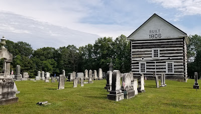
A German immigrant named John Schell settled in the valley in 1798. A few years later in 1806 the old Historic Church (GC8XJ1E) was built and the first burial outside the church. It wasn't until 1860 when Peter Schell, the son of John Schell, formed the Chestnut Ridge and Schellsburg Union Cemetery (GC8XJ11) was created. The town of Schellsburg was chartered and became official in 1908.


A few miles down the road and we turned north on I-99 heading towards Connecticut. The next county to the north is Blair County. My last geocache of the day was in Altoona, PA. Out in front of the Veterans Administration building is the Vietnam War Memorial which also includes a replica of the Wall. The Wall was also a virtual geocache (GCG5X5).


Well it's just after 7 PM and it has been a long day. Time to go find some dinner and a place to crash for the night. It was a great day with that historical unexpected stop. Time to get some rest and looking forward to tomorrow.

To follow along on our travels and keep up with my latest blogs, you may do so here of course by clicking the "Follow" button to the right. And there's also my main website at AwayWeGo.US for the complete index of my traveling adventures going back to 2005. But also by using one or more of your favorite of these social media platforms: FacebookMeWeGabRedditTwitterGETTRInstagram, and TruthSocial. These all link directly to my profiles. Again, please feel free to comment and / or share.

Friday, February 18, 2022

2020-10-18: Westbound Roadtrip Through North Carolina and Tennessee

Westbound and down, eighteen wheels are rollin'.... OK, so there aren't 18-wheels. But our time in North Carolina has come to an end and I gotta week to start the next project in Guy, Texas. TIME FOR ANOTHER ROAD TRIP! Time for geocaching, sightseeing, and exploring more backroads and byways between here and there.

Today we drove all the way over to Chattanooga, Tennessee. We discovered an old mill, a waterfall, a giant Harley-Davidson, a copper mine, and a historic cemetery. So climb into the GeoJeep and let me show you...


Not to take up too much time starting out, I quickly drive up to I-40 and head westbound. The first few hours were nonstop all the way to Cherokee, NC and our first geocache (GCGYMA).

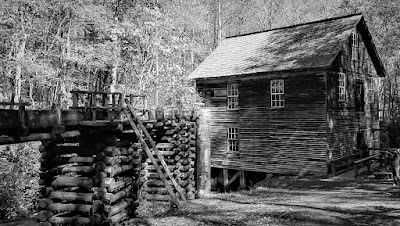
For 50 years, nearby farmers brought their corn and wheat to Mingus Mill, built in 1886. The miller usually charged a toll of one-eighth of the grain the customer brought for milling. The gristmill's stone was turned by a water-powered, cast-iron turbine. From water pressure built up in the penstock at the flume's end, the turbine generated 11 horsepower, enough to run all the mill's machinery. On the second floor, the smut machine blew wheat grain free of debris, while the bolting chest separated ground wheat into grades by sifting it through fine to coarse bolts of cloth.

Mingus was the largest gristmill in the Smokies. Its 200-foot-long wooden flume brings water to the mill's turbine. As early as the 1820's, more progressive millers began using turbines to power their mills rather than waterwheels. The Mingus family sold the mill to the National Park Service in the 1930's.


Continuing the scenic drive west on US-74, we headed for Juney Whank Falls and our next geocache (GCMBAZ). This puzzle cache requires gathering information along the 4.4 mile Deep Creek - Indian Creek loop trail. However once we arrived at the trailhead we weren't up for a long hike. So we just took the short hike to the first of several waterfalls for some photos.


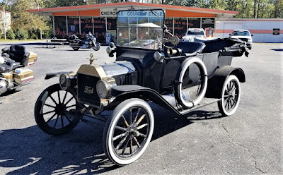
Here's one of those reasons why I like driving the backroads and byways through rural towns and communities across this great country. Passing by Cherokee County Cycles, I spotted this HUGE Harley-Davidson custom motorcycle along with a couple of other cool vehicles in the parking lot. I just had to pull in and get a few pics!


Crossing over into Tennessee, we check out the Great Copper Basin Earthcache (GCNP87) and a new caching county of Polk County. In 1843, a prospector, hoping to find gold south of the Coker Creek mine fields, instead located one of America's richest copper reserves. Over the next century, American and foreign companies chartered more than a dozen copper mines in the Ducktown Basin. The last mines closed in 1987. Many of the buildings still remain today.


We ended our day in Chattanooga at the National Cemetery for two virtual geocaches (GC5148, GC4E66). On Dec. 25, 1863, Maj. Gen. George H. Thomas, “The Rock of Chickamauga," issued General Orders No. 296 creating a national cemetery in commemoration of the Battles of Chattanooga, Nov. 23-27, 1863. Gen. Thomas selected the cemetery site during the assault of his troops that carried Missionary Ridge and brought the campaign to an end. The site Thomas selected was approximately 75 acres of a round hill rising with a uniform slope to a height of 100 feet; it faced Missionary Ridge on one side and Lookout Mountain on the other. Gen. Grant established his headquarters on the summit of the hill during the early phase of the four-day battle for Lookout Mountain.


By 1870, more than 12,800 interments were complete: 8,685 known and 4,189 unknown. The dead included men who fell at the battles of Chickamauga, Missionary Ridge and Lookout Mountain. There were also a number of reinterments from the surrounding area, including Athens, Charleston and locations along the line of Gen. Sherman’s march to Atlanta. A large number of men—1,798 remains—who died at the Battle of Chickamauga were relegated to unknowns during the reinterment process. In addition to Civil War veterans, there are 78 German prisoners of war buried here.

The Andrews Raiders Monument, erected by the state of Ohio in 1890, is among the most unique memorials in the cemetery. The granite base and die is topped with a bronze replica of “The General,” the Civil War-era wood-burning locomotive famous for its great chase of 1862.


Today, the Chattanooga National Cemetery encompasses just over 120 acres and nearly 60,000 permanent residents.

After 300 miles of driving, it was time to call it a night. Tomorrow is another day with new adventures and things to see. I hope you have enjoyed today's journey and will return for many more...

To follow along on our travels and keep up with my latest blogs, you may do so here of course. But also by using you favorite of these social media platforms: FacebookMeWeGabRedditParlorTwitterRVillageGETTR and Instagram. These all link directly to my profile. Again, please feel free to comment and / or share.

Saturday, January 22, 2022

2020-07-04: Day 2 of Our Roadtrip Through the Smoky Mountains and Finding Fugitive Crash Site and Smallest Post Office

Welcome back friends, Jeepers, Geocachers, RVers, and Adventurers. On this Day 2 of our long weekend roadtrip geocaching through the Smoky Mountains, we got to see the beauty of the mountains while discovering some other sites of interest as well. Such as the bus and train crash scene from the movie "The Fugitive" and the smallest post office in the country. But not to get ahead of myself. So climb aboard the GeoJeep and lets go exploring.


Leaving Morganton, I drove back north towards the Blue Ridge Parkway. Our first stop was just a simple LPC (Light Post Cache)(GCV6EB). It made for a quick stop and credit for Mitchell County. Now usually you'll find just a pill bottle with the logsheet inside under these skirts. But this was a first time for me seeing that the entire skirt was used as the geocache container.


A few miles later over in Yancy County, I made another quick park and grab geocache stop to claim a find in that county (GC18PVC). Continuing on US-19 over into Madison County, we made a stop at the Mars Hill Recreation Park for one more quick geocache (GC5CWVV).

The next one on the list is just another of the many reasons I like Geocaching. In Jackson County, specifically in the town of Dillsboro along the banks of the Tuckasegee River, there's a geocache hidden up above the Fugitive Train Wreck (GC3F9ZA). In the 1993 movie "The Fugitive," starring Harrison Ford and Tommy Lee Jones, included a wreck involving a train and a prison bus. 


This wreck was staged near Dillsboro on a rail siding in the GSMR maintenance yard, between the working rail tracks and Haywood Road, the rail cars and bus remain in the same location today. Year round you can get a good view of the Illinois Dept of Corrections transport bus. But as you can see from our photos, the train is a bit hard to see with all the summertime foliage.


We even drove around to the other side of the river to get a different view, but not much better. The best view of the wreckage would be to take a ride on the Great Smokey Mountain Railroad which runs on the tracks right along side of it.


Driving west on US-64 to Clay County, the most western North Carolina county we needed to complete our map, we target the nearest geocache "The Legend of the Fairy Cross" (GC3GX90). This section of US-64 runs alongside Buck Creek. We exit the highway closer to the geocache onto the parallel National Forest Road, which looks like it might have been the Old US-64.


There was a small pull-off area to get to Buck Creek, so I decided to stop for a moment for some photos. I like these old roads enclosed by bushes and trees. After a few minutes of enjoying the sounds of the creek and taking some photos, we drove up a little further and turned onto Buck Creek Road.


For all my geocaching friends I thought I'd post a rare photo of my GeoJeep. Usually I'll post just the hood logo in front of something or have the tracking code blurred out like in the pic above. I'm only gonna leave this here a week, maybe longer, so log your "Discovered It" soon. I don't normally allow virtual discoveries so please don't copy this photo to your social media sites. And please include the location of where I'm parked in your discovered log. Thanks.

50ATJ9

Now back to the geocache. According to the description on the cache page: "this general area has a great history of minerals and mining. We are aware of at least 4 abandoned mines nearby. One of the minerals unique to the area is staurolite crystals, also known as fairy crosses because of their unique shape.

"Two thousand years ago, so the Cherokee legend of Fairy Crosses begins, the "Yunwi Tsunsdi," or Little People, lived in the beautiful mountains of what is now North Georgia and Western North Carolina. Shy and elusive creatures, the Little People were revered throughout the Cherokee Nation for their ability to find people lost in the thickly forested mountains of the region.

"One evening, while the Little People were enjoying an enchanted celebration of dance, music and song, a foreign messenger arrived bearing the sad news of the Crucifixion of the Son of the Great Creator. So moved were the Little People upon hearing the news of the loss of one so great, that they were moved to tears. As their tears fell to the ground, they turned into Fairy Crosses, where they can be found to this day."

Well I don't know anything about the little people or fairy crosses, but I did find the geocache down by the creek. I looked along the banks a few minutes for some minerals or cool rocks, but I didn't see anything special. Didn't want to spend too much time there though.


Finally rounding the corner and headed back to the east towards the campground, we followed US-64 into Highlands and Cashiers. Once in Highlands, I started taking the rural backroads to my next stop. It was there we found the Smallest U.S. Post Office in the country, at just 6 feet by 6.5 feet.

Originally built in 1878 about a mile away on Whiteside Road next to a grist mill at Sliding Rock, our next stop below. It remained there for 69 years and its first postmasters were Thomas and Elizabeth Grimshawe. In 1911 the Grimshawes sold their property to Warren and Lena Alexander who acted as the postmasters for 36 years. In 1947 they sold their property and the post office was moved near its current location once owned by the Alexander's daughter. Mae Alexander Passmore was postmaster for the final 6 years until President Dwight Eisenhower closed all third class post offices in 1953.


It was then moved and used as a ticket office and post card stand until returning here in 1976. Falling into disrepair and still getting the occasional tourist visitor, in 1999 neighbors decided to restore the post office and move it off the road a little bit and provide safe parking. From the photos displayed inside, the front area where I'm sitting was the customer area and the back half for mail and storage. Currently hanging on the back wall is the last flag which flew over the post office from the 1950's.


Driving a mile up the road we get to Sliding Rock. Actually a waterfall flowing over a large smooth rock, it turns a creek into a natural waterpark. A popular place in the summer time to cool off as you can see. There was a geocache on the short trail leading from the parking area to the rock but I couldn't find it. (The cache has since been archived as many others could not find it as well.)


And finally, one last quick roadside geocache (GC3C0B0) in Transylvania County to complete my final 100 North Carolina counties Geocaching map!

That was it for Day #2 of our long holiday weekend. On Day #3, Candy wasn't feeling well and we drove nonstop back to the campground at Lake Norman. I hope you have enjoyed this roadtrip through the Smoky Mountains. And perhaps found something I've written about to add to your bucket list of places to visit. See you back real soon.

To follow along on our travels and keep up with my latest blogs, you may do so here of course. But also by using you favorite of these social media platforms: FacebookMeWeGabRedditParlorTwitterRVillageGETTR and Instagram. These all link directly to my profile. Again, please feel free to comment and / or share.

Saturday, January 15, 2022

2020-07-03: A Long Weekend Geocaching Counties and Hiking in Western North Carolina

Well we're working in North Carolina and have a 3-day holiday weekend. Do we chill at the RV Park or go exploring the Smoky Mountains and Geocache the remaining six counties to complete the state? It's a roadtrip of course! Grab the hiking boots, hop into the GeoJeep, and let's go sightseeing along the backroads of North Carolina!


Leaving the Lake Norman Motorcoach Resort behind for a few days, we headed west on NC Highway 18 until we got near Pleasant Grove. There we made a detour over to a bridge on Old North Carolina 18 for a First-to-Find attempt at a geocache published two days earlier (GC8VWYF). Another geocacher tried to find it the same day it was published without any success. I tried searching for nearly 30 minutes. But it wasn't for me to find on this day. I ended up having to log a DNF.

Driving north on US-321, I get off at the Mulberry exit for our next geocache (GC8MRYY). It was located near Silvervale Falls. These cascading falls are about 80 feet from top to bottom. Being this far from the Blue Ridge Parkway, there aren't as many tourists visiting these waterfalls. Only enough parking for 3 cars and we didn't have any problem. But worth the stop if you happen to be nearby.


One of the other reasons I like geocaching and traveling the backroads is that you never know what you might come across. Like this old rusty car, truck, and tractors lined up on the side of the road. I just had to stop and get a few photos.


Our next stop WAS to be Blowing Rock and then Grandfather Mountain. I've visited the Smokey Mountains and the Blue Ridge Parkway many times. However I have never made it to these two popular tourist destinations. Today it was going to be another of those times. It was July 4th weekend and the places were packed full and we did not want to contend with the crowds. So we continued on southbound down the Blue Ridge Parkway.

One of the first photo opp stops we took along the parkway was at the Wilson Creek Valley Overlook. A great view and you can see for miles!


Our next stop was a hike for a virtual geocache in the Linville Gorge Wilderness Area. The Linville Gorge Wilderness is part of the Pisgah National Forest. The gorge is formed by the Jonas Ridge on the east and Linville Mountain on the west and is bisected by the Linville River which drops 2,000 feet into the valleys below.

The virtual geocache (GC3A44) was a hike down the Spence Ridge Trailhead. This trail was supposed to take us down to the Linville River where we were to find the "House Rock," a flat top rock formation in the river that looks like a house. I wish I could show a picture of it, but we never made it. After about an hour of hiking, we were slowly getting closer but the destination appeared to be staying off to the right. Finally we decided to turn around and head back to the GeoJeep. As we were hiking back I noticed the correct trail we should have stayed on teeing off. Oh well, maybe next time.


Driving our way around to the other side of the Linville River we headed for our next virtual geocache called "Look At That" (GCG9YT). After 3.5 miles of gravel road, a little rough in a few spots, we made it to our destination at the Wiseman's View Scenic Overlook. Just a short walk from the parking area and you'll arrive at this viewing platform high above the gorge.


Driving back along the 3.5 mile gravel road, which is the Old NC 105 / CR 1238, I spotted this old road marker off the side in the weeds. After a few hours of research, Andrew Milton Kistler (1871-1931) was originally from Pennsylvania and became a prominent businessman in Morganton, Burke County, NC. First established in 1926 as the primary route between Nebo and Linville Falls, a 24 mile road that has since been rerouted and improved. The remaining Old NC 105 is now 17 miles of gravel road which can require 4x4 in some areas. That just added to the adventure in the GeoJeep.


We ended the day in Marion, NC. It was a pretty good day with the sightseeing, the hiking, the off-roading, and a little bit of history. I hope you have enjoyed todays adventure. See you back soon for another day of exploring the Smoky Mountains in Western North Carolina.

To follow along on our travels and keep up with my latest blogs, you may do so here of course. But also by using you favorite of these social media platforms: FacebookMeWeGabRedditParlorTwitterRVillageGETTR and Instagram. These all link directly to my profile. Again, please feel free to comment and / or share.

Wednesday, February 24, 2016

2016-01-10: Geocaching Around Lubbock Texas

Because it was so cold yesterday, today we decided to stay local and do some urban Geocaching around Lubbock. Our first stop was to see the Buddy Holly Center and Museum. It was closed this early, but we did get to see the giant glasses (a virtual cache GC6E04) and the memorial statue (GC640VA). Buddy Holly's hometown was Lubbock, Texas and they certainly pay tribute to him.


Not too far away over at the Eastlawn Memorial Gardens, is another virtual Geocache (GCC1AB) at Buddy Holley's gravesite next to his parents. There'a another Geocache here (GC1KJJV) highlighting the supposedly haunted aspect of this cemetery. This cemetery is one of the largest in Texas with over 60,000 graves and was established back in 1892.


Also while in the cemetery and with all the snow on the trees, Candy couldn't help it but to go over to one of the trees and shake all the snow off the branches! By selecting one of the taller branches, that also meant it comes down on her head too.


Exiting the backside of the cemetery brought us out to the Canyon Lakes Park. Within the city limits of Lubbock is the Yellow House Canyon, a narrow and shallow channel. The city created a series of small dams that created a series of narrow lakes. And Canyon Lakes Park was created. There's also a series of eight Geocaches around the lake as well. And of course we can't just leave them without looking first!


From there, we drove over to the campus of Texas Tech. Since it was Christmas Break, there weren't many students still here which made Geocaching a little easier. Though most of the ones we looked for, we could not find. We did see some very nice statues.


So that was it for today. We did learn a lot about the local history. Now time to go back to the apartment and thaw out again.