Showing posts with label Rio Grande Valley. Show all posts

Saturday, August 28, 2021

2019-12-28: Spending the Day in Big Bend National Park

It's been 13 years since I was last here at Big Bend National Park in West Texas. Spending the last few years just a few hours north of here, I figured it was about time I paid another visit. We spent two nights in Alpine, TX as our base so we could get here early, stay all day, and not have a long drive home afterwards. Big Bend NP is over 1200 square miles and that's a lot to explore and see. So let's get going!


We arrived just after dawn to a cloudy morning which kinda hindered having some great sunrise photos. Our first geocache was an earthcache called "Fins of Fire" (GC3AZVV) facing the Chisos Mountains to the east, describing the layers and spikes and the creation of the mountains from volcanic activity.


Continuing the beautiful route down the Ross Maxwell Scenic Drive, we arrived at the Solol Vista Overlook and another earthcache (GC2NJRH). The amazing views here are awe inspiring. And from this vantage point we barely get a glimpse of our destination Santa Elena Canyon some fourteen miles in the distance. From here though it's just a tiny notch in the mesa across the valley.


In the panoramic photo below taken from the Sotol Overlook, from left to right are: Trap Mountain, Goat Mountain, Santa Elena Canyon, Kit Mountain, across the valley to Tule Mountain, Burro Mesa, Little Christmas Mountain, and Christmas Mountain.


After the overlook, we stopped at Tuff Canyon for another earthcache (GC72D1C). Tuff Canyon is the deepest of the dry washes in Big Bend NP. This also makes it very dangerous during or after a rain as the gathering waters pick up velocity and can cause a flash flood rushing between the canyon walls. Over time the rushing waters slowly dig a deeper channel while at the same time eroding and smoothing the layered rock walls.


The mountains and cliff walls are plentiful. Just driving the roads, you won't even need to get out of your car to be amazed at the views.


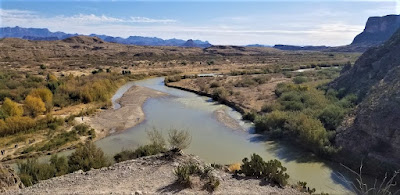
Now we get to the Santa Elena Canyon observation area (GC37ECH). The Santa Elena Canyon is one of the most famous landmarks within Big Bend National Park. Looking from the overlook area, that's the United States on the right, Mexico on the left, and the shallow Rio Grande River flowing up through the middle and curving to the left. A lot of people stop there to get their photos. However if you keep following the road around, it will take you down to the entrance, or should I say the exit.


Where the Rio Grande exits the canyon, there's the Santa Elena Canyon Trailhead. The Terlingua Creek drains into the Rio Grande River just as it exits the canyon. You can see it in the next photo coming in from the left. Most of the time the water level is low enough and you can easily walk across rocks without getting wet. Once you cross over and climb the short hill you enter the trailhead that has been paved creating an easy hike with stairs and switchbacks up 160 feet to the point from which I took the photo.


Once you make the short hike up and over at the trailhead, you make your way down the trail into the cool canyon. Because of the 1500 feet canyon walls that seem to raise up forever, they block out the sun except for the short time it is directly overhead. We continued our hike down and back to see how far we could go. Officially it's a 1.5 mile out and back hiking trail.


At this point, we came to the end of the trail. This is about as far as you can hike without getting wet. Now I was wanting a kayak so I could keep going to see what's around the corner. One of these days I just might do that.


Backing up a little ways there's this huge rock that had fallen near the edge of the bank of the Rio Grande. I talked Candy into climbing out on the rock with me and handed my phone to another hiker to take our photo. I think this turned out much better than trying to take a selfie and still get the full canyon effect.


Having made our way back in the GeoJeep, it was time to hit some of the offroad trails. First we drove back up the Ross Maxwell Scenic Drive and looped around over to the Panther Junction Visitors Center. This time we finally bought one of those National Park Passport books that you get stamped each time you visit a national park or historical site.

From there we made our way down to Glenn Springs Road. It's a gravel road that even a regular car can make it through, see the first pic at the top of the blog. There might be some parts that may be a little rough, but I'd drive down most of it if I still had the Prius and the turn around if I got to an impassible section.

After several miles it turns into Black Gap Road as it nears the spring. There it does become a rougher section that really requires high clearance vehicle. Just past the Glenn Spring primitive campsite I found my next virtual geocache (GCR2A8). The U.S. Calvary once used this location for a few years. If you look hard enough you can still find parts of the foundations of some of the buildings. At the top of the nearby hill you'll find some scattered wooden crosses for the cemetery. To get credit for finding the virtual cache you need to email the number of crosses. The Find-A-Grave website only lists five memorials here. If you use that number you won't have the correct number as there are more than that. And not having any names on the wooden crosses, they are known only to God.


Another hour or so of offroad fun in the GeoJeep and we make our way to the exit roads and back up to Alpine, Texas. It wasn't until later that I realized the Black Gap Road was one of the trails in the Jeep Badge of Honor series. If I had used the BoH app to check in from the trail, I could have gotten my first badge. Oh well, I guess that's a good excuse to have to come back and explore some more of the Big Bend National Park. There is still much to see out here that I haven't gotten to yet. And I recommend this place to be put on your bucket list one day. Just try to avoid summer as the temps are easily in the triple digits!

To follow along on our travels and keep up with my latest blogs, you may do so here of course. But also by using you favorite of these social media platforms: FacebookMeWeGabRedditParlorTwitter, and Instagram. These all link directly to my profile. Again, please feel free to comment and / or share.

Saturday, December 12, 2020

2019-04-02: Driving Over to South Padre Island, Texas to Find Virtual Geocaches

Hey everybody! So after being off work for nearly two months, they've called me back to the wind farm down in the Rio Grand Valley in South Texas. I've enjoyed the time off out geocaching as you may have guessed from my previous blog posts. But after a couple of geocaching roadtrips, it's time to go back to work.

Being back for a week, today we got some rain which made it a little too wet and muddy to work. So we got off a bit early. But it's never to wet for geocaching. I decided to take a short roadtrip from the westside of the RGV to the eastside.

I arrived on South Padre Island, Texas and to my first virtual geocache (GCB15D). "Sailed Through This Pass" is a monument dedicated to the brave fishermen who have used this port and ventured into the Gulf of Mexico.


Now backtracking westbound, the next two virtual geocaches are near the Welcome to South Padre sign at the bridge to the island. Well actually one of them IS the welcome sign (GC7B7K1). And the other is nearby for a reminder of when an 80 feet section of the Queen Isabella Memorial Causeway bridge collapsed after a barge accidently hit one of the pillars in 2001. The virtual geocache (GC8753) recognizes the memorial for the eight motorists who lost their lives as well as a monument for the survivor.

There's also a statue of the islands namesake. Padre Jose Nicolas Balli's (1771-1829) family immigrated from Spain in 1569 and became large landowners in the lower Rio Grande Valley. In 1800 Balli applied to King Charles IV of Spain for 11 1/2 leagues of land on the island, and in 1804 started its first settlement, Rancho Santa Cruz. Padre Balli served as collector of finances for all the churches in the Rio Grande Valley. He also founded the first mission in present Cameron County. His ministry was a great influence on the lives of early South Texas settlers.


Back on the mainland side of the bridge is the "Beacon of the Night" (GC83C9) virtual cache. The Point Isabel Lighthouse was built of brick in 1852 and brought from New Orleans by schooner. The beacon's 16 mile range guided ships into the harbor and to the Rio Grande. It is one of the oldest lighthouses on the Texas Gulf Coast. It also played a significant part in military operations around the mouth of the Rio Grande for over a century, with some interruptions, has served the region as an aid to seamen.


The next virtual geocache called "Catch and Release" (GCAEC0) was located at the Pirates Landing Restaurant. Supposedly there was a world record sheepshead fish caught there on the pier. Looks like a big fish. Is it true? Can't tell you that as I haven't found any verification of such record. But what I did find was the World Record Largest Fly Fishing Rod.


And finally the last one I had time for was the Palo Alto Battlefield National Historical Park (GCC88D). This prairie of sharp cordgrass, dense mesquite, cactus and other thorny plants was the location of the first battle of the Mexican War. United States troops led by General Zachery Taylor, whom later becomes the 12th U.S. President, went up against and defeated Mexican troops led by General Mariano Arista.


Well that's it for this quick trip across the Rio Grande Valley. Time to grab a quick bite to eat and drive the couple of hours back to Falcon Lake on the westside. I hope to see you back again soon for another installment of the AwayWeGo's Geocaching Adventures. 

Saturday, December 5, 2020

2019-04-01: Geocaching and Exploring Early Mexican-American History in the Rio Grande Valley of Texas

Hello and Welcome Back! So after my long and packed roadtrip from Texas to Minnesota and back, I had another two weeks off before getting called back to the wind farm down in the Rio Grande Valley. I managed to get one week of work behind me before overnight and this mornings rains made it too muddy to work. But a rain day off from work means an extra day for geocaching and exploring early Mexican-American history of small towns in the Rio Grande Valley.


My first stop is the town of Roma, Texas, just a few miles down the road from where I'm staying. A new cache was published over the weekend called "Cactus House" (GC85FFK). Just a couple of blocks from Roma's point of entry bridge over the Rio Grande River into the United States, is an old long abandoned brick house that's been taken over by nature. I found the geocache on this Monday morning and a nice clean log sheet to claim a First-to-Find!


From there I went a few blocks over to the Roma Historic District. Not a typical border town settlement, Roma, founded in 1765, is distinctive for its historic high-walled, gated, family compounds that reflect strong ties to 18th century northern Mexico, which was then part of the Spanish Empire. The planning, colonization and land grant system was the brainchild of Jose de Escandón and focused on civil development. Today, Roma is the only American Spanish colonial settlement that preserves the character of Escandón’s town planning.

The community is directly across the river from Ciudad Miguel Alemán, Mexico. The Roma Historic District, a National Historic Landmark district in the City of Roma, contains architecture influenced by Spanish colonial culture and by the bustling 19th century Rio Grande trade route that brought goods and people from the Gulf of Mexico to the continent’s interior. The Roma Historic District contains the best and most intact collection of ethnically diverse buildings and structures in the border region.

The site of Roma was part of the Mexican town of Mier about 10 miles northwest of modern Roma, in what was New Spain’s Nuevo Santander. Don José de Escandón founded the Spanish colonial province of Nuevo Santander in the mid-18th century. Spanish colonists from Mexico settled Mier in the 1750's and received land grants along the Rio Grande, where they formed family ranches. In the 1760's, the Spanish colonial government granted two tracts on the northern side of the river to the Salinas and Sáenz families, who were among the founding families of Mier and whose descendants still reside in Roma. The tracts they received were the first permanent European settlements at the Roma site.

Soon after the Mexican War for Independence ended in 1821, Roma became an independent community. One of the earliest records of Roma is in American colonist Stephen F. Austin’s chart of Texas, which literally put Roma on the map. After the Mexican-American War ended, Roma belonged to the United States. In the 1840's, Euro-American entrepreneurs settled in Roma, Texas, and married into the founding families.

German immigrant and master-builder Enrique (Heinrich) Portscheller settled in the region in 1865, married a Mier woman, and eventually moved to Roma. Portscheller added to the beauty of the local building techniques with his trademark decorative molded brick and use of New Orleans-type wrought-iron balconies. In addition to his work in Roma, Portscheller designed buildings in the border towns of Mier, Rio Grande City, and Laredo. Though there are other towns where this type of brickwork endures, Roma sustains the highest level of density, integrity, and quality in its 19th century Rio Grande brick and stone craftsmanship.

The John Vale / Noah Cox House (GC7JGVK) served as both a home and business location for John Heinrik Vale and Noah Cox, who were deeply embroiled in Civil War activities in Roma. Vale, a Swedish immigrant, had come to America in 1840 seeking adventure. During the Mexican American War, Vale volunteered for Zachary Taylor’s Army of Occupation and was encamped in Camargo. He chose to remain in the region, marrying a woman from Ciudad Mier in Tamaulipas and taking up residence across the Rio Grande in Roma. In 1853 he built a two-story home on the town’s main plaza.


Three years later he sold the house to Cox, a representative of the New Orleans firm of Stadeker & Mecklinburger & Cox, who continued to use the house as both a residence and mercantile center. In addition to his mercantile operations during the Civil War, Cox also served in the Confederate Texas Cavalry. For his part, Vale engaged heavily in the lucrative cotton trade that funneled through the city of Roma during the Civil War, doing business with Joseph Kleiber, a key player in Confederate business operations on the Gulf of Mexico. 

The geocache I found, my second attempt at looking, was on the ruins of the wall which surrounded the side and backyard. Hopefully they don't completely restore this section of the wall because I like the way it looks now.


Also built by John Vale around 1850's, the Leocadia Leandro Garcia House is similar in style and construction to the Noah Cox House across the Plaza. Originally, the house contained commercial space on the ground floor with residential space above. The house was later remodeled as a building for a dance hall and now owned by the Knights of Columbus.


Manuel Guerra, the legendary political and economic boss of Starr County, commissioned Portscheller to build his family compound in 1884. A native of Mier, Guerra printed his own currency to be redeemed by his ranch workers at his store. The two-story brick structure sits assuredly along the upper western edge of the plaza, extending for half a block with fine classical brick detailing and a historic two-color metal balcony that delicately embellishes its second story. A one-story warehouse completes the L-shaped complex enclosing a courtyard with original outbuildings. Never to be outdone by competitors, the Guerra family also operated the first gas station in Roma with a pump installed near the chamfered corner entrance (since removed).


The seven men, pictured in 1911, in Roman collars and broad brimmed hats were Missionary Oblates of Mary Immaculate (OMI) who had travelled from their missions scattered throughout the Rio Grande Valley along the river. Since 1849, this Calvary of Christ have been building churches and chapels from Brownsville to Laredo.


Arriving in Mission, Texas and turning back towards the river, I make another stop in Anzalduas Park. It's a riverside park popular with bird watchers. I was here once before and found a couple of geocaches. But there was one that I previously DNF'd (GC6AF7Y). Today was redemption as I found it this time. Out on the Rio Grande I could see why this park was popular among bird watchers.


At my next geocache (GC84NC2), I see the ruins of this structure up on the hill. Next to the Juan Diego Academy stands the remains of the Villa Queen of Peace (photo below and at top of page). Though the cache page says Oblate Monastery, I can't find any information about it's history or that it was indeed a monastery. So I'm not sure when it was built or what happened to it. If you have any information as to its history, please comment below.


Nearby was geocache (GC6Z60B) and my next piece of history. The La Lomita (meaning small hill) Chapel was constructed by the Oblates in 1865, then rebuilt in 1899 on these 122 acres willed to them in 1861 as it was nearly halfway between Brownsville and Roma. The Oblates moved their ministry to the growing city of Mission in 1908. Now it is a historical landmark, a park, and a place of pilgrimage.


Looks like an oven outside the chapel.


I hope you have enjoyed the sampling of early Rio Grande Valley history. There is much more to see if you every get the chance to be down in this area. I didn't even get to any of the cemeteries. Overall I managed to find many more quick roadside geocaches for a total of 32 finds for the day.

Until next time, I look forward to your comments here or on any of my social media accounts. Hopefully I have inspired you to go out and explore the rich history along the many backroads and small towns of this great country.

There are new ways to follow me. Follow the blog directly by using buttons on the right of your computer screen. Or through various social media platforms:  FacebookMeWeParlerGabTwitterInstagramMAGAbook, and Reddit. Follow us on any or all of these platforms and whichever you choose, please leave your comments. We'd love to hear from you and it encourages us to continue sharing our adventures.

Saturday, September 12, 2020

2018-09-12: Completing Geocache Counties Along the Texas Gulf Coast

Welcome back to the Rio Grande Valley in South Texas on a wet Wednesday. It's still too muddy at the jobsite to work. So it looks like another day of Geocaching! And I've got just the thing. I've been working on completing my Texas counties. There are a total of 254 counties in Texas. I need two at the very top of the panhandle, two north of Dallas, and there are four left here along the Gulf Coast.

I quickly get underway across the state, I've got a lot of driving to do today. My first stop is a geocache (GCQJCF) at a historical marker in Matagorda County. Camp Palacios was established on this site in 1925 as the summer training camp for the Texas National Guard's 36th Division, which had formed during during World War I as the 36th Infantry. The division, which became the 36th Infantry Division during World War II, trained here each summer, 1926-1937 and 1939. Located on the Turtle and Tres Palacios Bays, the land was donated by Palacios area citizens. More than 6,000 guardsmen arrived in July 1926 for the first training session. In 1930, the camp was renamed for Major General John A Hulen (1871-1957).

On its 1,200 acres, the new camp supported the largest concentration of troops for field training in the United States Military, with facilities for several thousand inhabitants. In 1940, the War Department leased camp Hulen; first to undergo Anti-Aircraft training were National Guard units from several states. By 1941, the City of Palacios suffered a housing shortage that was alleviated by Government housing for military families and civilian workers near Camp Hulen. After extensive development, the camp had facilities for 12,000 military personnel.

Basic training continued until early 1944, when U.S. Soldiers were removed. German prisoners of war, guarded by a small contingent of U.S. personnel, were housed here from 1943 to 1945. In 1946, the War Department returned Camp Hulen to the National Guard, for whom it had become too small. Buildings were slowly dismantled and sold. In 1965, the property was sold jointly to a group of Palacios citizens and a development company.

Next stop in Port Lavaca, Texas over in Calhoun County, I come to a virtual geocache (GC84D1). Constructed in 1858 this three-story hexagonal lighthouse was originally located in Matagorda Bay, at the southern tip of Half Moon Reef. The beacon served as an aid to ships trading in Port Lavaca and nearby Indianola. The beacon was in service till 1943 when it was moved to Point Comfort, then moved to it's present site in 1979. The beacon was restored as a community project and placed on display.


Also in Port Latava is another virtual geocache of historical value (GCG8JQ). At the VFW Post 4403 is a Vietnam War Memorial. This Army helicopter saw action in Vietnam and Desert Storm. It has the capability of carrying two tons of ammunition to fire from machine guns, cannon and grenade launchers. It had the distinction of being the most heavily armed helicopter in Vietnam action. This swift and hardy craft became one of the most celebrated tools of the Vietnam War.


The last virtual geocache here was at Indianola, Texas (GCDFB7). Of the many ghost towns of Texas, none lived longer, none thrived better, none died as tragic a death as Indianola, on the west shore of Matagorda Bay near where Rene Robert Cavelier, Sieur de la Salle, is thought to have landed in 1685. Many colonists, including the German immigrants led by Prince Carl of Soms-Braunfels entered Texas at this natural port. It was an important military port, a railhead, and a diplomatic center where commissioners of Mexico and the United States met to establish boundaries proscribed by the Treaty of Guadalupe Hidalgo. The port exported cattle to the East and Cuba. In 1875, at the heights of its prosperity, population 6,000, a tropical storm took toll on lives and property. After a second storm hit a year later Indianola was abandon. Now only a fishing and vacation community remains of this famous Texas city.


Next up in Refugio County was my next geocache at the Tivoli Cemetery (GC4NHZ7). Captain Newton Cannon Gullett who founded Tivoli, Texas on his ranch of the same name. Gullett erected a cotton gin, store and a boat landing on the Guadalupe River to export cotton and receive supplies. 

The town was first platted in 1907 by Preston R. Austin and a post office was granted in 1912. The St. Louis, Brownsville and Mexico Railway was extended through Tivoli (to the terminus at Austwell) that same year. The town was re-platted in 1913 - doubling the size of the town from five blocks to ten. Austin donated the town's first church and school. Hurricanes hit Tivoli in 1919 and 1942, but the shallow bay, high bluffs and slight population spared the community from obliteration. The town reached its population zenith in 1928 with a population of 700. The next photo is one of the old abandoned houses in the town.


Continuing to make my way back, I enter into Aransas County and the historic Lamar Cemetery (GC188TK). According to the historical marker, this burial ground originally served members of the Lamar Community. Founded by James W. Byrne (d. 1862), a native of Ireland and a veteran of the Texas Revolution, it was named for his friend Mirabeau B. Lamar, President of the Republic of Texas from 1838-1841. The earliest grave is that of Patrick O'Connor (1822-1854), a bookkeeper for Byrne's business operations in New Orleans. The town of Lamar ceased to exist by 1915 and the cemetery was neglected until the 1940's when it was restored through efforts by the family of John Henry Kroegor, Jr (d. 1944).


Crossing the bay down into Fulton, Texas, I found my next geocache in the Fulton Cemetery (GC188TK). Land for this community graveyard was set aside when the town of Fulton was platted by George Ware Fulton in 1868. The earliest documented burial is that of a child, Louis L. I. Greenough (1868-1869). The large number of children's graves attests to the often harsh conditions of pioneer life. Also interred here are European immigrant settlers, prominent local citizens, and veterans of the Civil War, World War I, World War II, Korea, and Vietnam. A brush fire in 1947 destroyed many of the early wooden markers, leaving some unmarked graves.


Just before crossing the bridge into Corpus Christi, in the town of Portland, was another geocache (GC58B90) call "Home Sweet Gnome" that had a lot of favorite points given to it. So I just had to go and check it out. It was a very creative cache someone constructed out of a tree stump.


Heading west now making my way back to Falcon Lake, I make a stop in the town of Alice to grab a geocache at the Collins Cemetery (GC119Y1). Alice, Texas is the town originated in the defunct community of Collins, three miles to the east. About 1880 the San Antonio and Aransas Pass Railway attempted to build a line through Collins, which then had 2,000 inhabitants. The townspeople were not amenable to selling their land to the railroad company; consequently, the railroad site was moved three miles west, and in 1883 a depot called Bandana was established at its junction with the Corpus Christi, San Diego and Rio Grande Railway. Bandana soon became a thriving cattle-shipping point, and application for a post office was made under the name Kleberg in honor of Robert Justus Kleberg. The petition was denied because a town named Kleberg already appeared on the post office list, so residents then chose the name Alice, in honor of Alice Gertrudis King Kleberg, Kleberg's wife and the daughter of Richard King. The Alice post office opened for business in 1888. Within a few years the remaining residents of Collins moved to Alice, which was by then a thriving community.

My last geocache was in a town called San Diego, Texas (GC78TC9). Early travelers between Goliad and Mier stopped to use the springs that fed San Diego Creek in what was to become San Diego. Around 1800 Julián and Ventura Flores (father and son) received two land grants known as San Diego de Arriba and San Diego de Abajo. The grants were surveyed in 1806 and they received their deed in 1812. In 1828 the first birth was recorded and the population was estimated at 25 families by 1844.

In 1846 Gen. Zachary Taylor and his troops briefly occupied the town during the Mexican War. In 1848 Ventura Flores sold land to Pablo Pérez, who built houses and named the town Perezville. The town's first post office was opened in 1852 in a small white building known as the Casa Blanca. It is said that Perezville was renamed San Diego at this time. This building was occupied by Confederate forces during the Civil War and it later served as a store, a speakeasy, a residence and a bar. It remains standing today.

Grabbing a bite to eat as well, it was still nearly two hours of driving back to the house at Falcon, Texas. After 600 miles today, I have completed the last of the southern Texas counties! Only a few more to go up north to complete the state. Thank you for riding along with me. I welcome you back again soon for another days adventure.

Monday, September 7, 2020

2018-09-11: A New Country, the Twin Towers, and Ghost Towns Along the Rio Grande in South Texas

Hello again and welcome back to another edition of AwayWeGo's Geocaching Adventures. AwayWeGo.US is my geocaching name which I have been using since 2006.

Today's adventure is due to an overnight and early morning rain in the Rio Grande Valley. This made for some muddy conditions at work. And when working outdoors in construction building a wind farm, that means a day off. But makes for a great day to go Geocaching and exploring!

Having never been to Mexico before, this would be the perfect opportunity to grab a geocache across the border to achieve my fifth country. And on this September 11th day, I have the perfect "twin tower" cache in mind.


But let's not get ahead of myself. I started out in the small community where I was staying. Falcon, Texas was moved from an original Falcon at the junction of Medio Creek and the Rio Grande in southeast Zapata County during the flood in August 1953, which was caused by the completion of Falcon Dam in December 1952.

Settlers had been brought to the area by Col. José de Escandón in the 1750's. The Spanish crown set the land aside for the colonists of Revilla, known as Guerrero, after Mexican independence. In the mid-1700's the king of Spain granted 6,123 acres to José Clemente Gutiérrez, who later sold the land to José Clemente Ramírez. In 1780 Ramírez married Margarita de la Garza Falcón, thus uniting two of the area's most distinguished families, and moved to the old site of Falcón. The place was called Ramireño de Abajo. In the early 1900's Ildefonso Ramírez opened a general store there.

In 1915 a post office was established, and the village changed its name to Falcon, in honor of the wife of the founder. This was done because there was already a post office a few miles away called Ramireño, at Ramireño de Arriba, and the post office needed a different name. Old Falcon had 4.01 acres in common riverfront and 12.27 acres in its town tract. The government offered to move the settlement of families to Zapata, the county seat, where good schools, parks, water, sewage disposal, and paved and curbed streets would be available; but the families, whose ancestors had come to the area, settled it and opted to keep their site.

The government closed the dam before paying for the land and improvements, figuring they had several years before the water would rise—there had been six years of drought. The water suddenly rose after four days of rain starting on August 23, 1953, and on August 28 the 450 families of Lopeño and Falcon were hurriedly evacuated in a pouring rain. By the day's end, only the church steeple, a few windmills, and the tops of a few houses showed above the muddy reservoir. Residents of the inundated communities left behind furniture, clothing, toys, even pets. Some walked rather than accept rides from the hated commission that had built the dam and driven them from their 200-year-old settlements. Later, the government refused to pay them the full price for their homes and belongings because they were no longer usable.

The government had also picked out a common site for all of the local cemeteries, but all of the villages affected by Falcon Dam voted to buy their own separate sites. A total of 162 graves was moved from the old Falcon cemetery, only ten of them unidentified. The cemetery today has over 300 permanent residents. There wasn't a geocache here yet, so I hid one myself (GC7XMCW).


Six miles to the north is the new town of Lopeño. It replaced old Lopeño and four other small farming and ranching communities - San Pedro, San José, Santa Fé and El Tigre. Lopeño is named for Antonio López, husband of Doña Ysabel María Sánchez, to whom a 6,366-acre land grant, named Señor San José, was given by the king of Spain on July 16, 1767.

During the early 1800's a parcel of this grant passed to the Ramírez family, founders of Falcon. In 1821 Benito Ramírez constructed a combination home, fort, and chapel, known later as Fort Lopeño, which stood until covered by the waters of Falcon Lake. It was built at the Lopeño crossing of the Rio Grande. There was also a famous shrine in front of his El Tigre Ranch well, where local residents drew water, and worshiped before the Señor San José Church was built in Lopeño. The shrine, dedicated to Our Lady of Guadalupe, was artistically cut from limestone, with beautifully carved hands and feet, delicate features, and a chaplet encircling the crown.

Company K, Fifth United States Infantry regiment, maintained Camp Lopeño there for twelve days ending May 10, 1856, before returning to Ringgold Barracks, Rio Grande City, during the Cortina War. Serafín Benavides established a store at Lopeño in the early 1900's, the only supply point in the area at the time. Andrés Serna carried the mail by horseback from Zapata to Lopeño from 1900 until his death in 1908; he had a keen mind, but could not read. Before starting his route, he would have the names and destinations read to him, and would sort them in order, never making a mistake in his delivery.

When the original Lopeño was about to be moved, the International Boundary and Water Commission wanted all the displaced communities to move their cemeteries to a single location at U.S. 83 and Farm Road 496, but the residents insisted on separate cemeteries. They mapped out their graveyards and identified 1,501 of the 1,753 burial sites; Lopeño had 207 burials, thirty-eight of which remained unidentified. The new community and cemetery are located on a 6,525-acre tract of land first granted in 1767 to María Josepha Guerra. I hid a geocache there also since it didn't have one either (GC7XMFN).


Continuing north on US-83, I arrived in the town of Zapata. Zapata dates to Spanish land grants that go back to 1767. When the first settlers crossed the Rio Grande the town was called Habitacion. Then Carrizo, then Bellville after Governor Peter Bell. Finally the permanent name of Zapata was authorized to honor Col. Antonio Zapata, one of the founders of the Republic of the Rio Grande. In the early 1850's, two military posts, Camp Drum and Camp Harney, were located at Zapata to combat border disturbances and prevent Indian attacks. The population of Zapata increased suddenly when people from Guerrero crossed the river to escape the Mexican Revolution. In 1953, Zapata was another border town that moved to higher ground when Falcon Dam was built.

I found my next geocache at the Mertens Frontier Ranch Store and Museum (GCZRE6). It was an interesting looking gift shop. Couldn't go inside though since it was closed. Maybe next time...


Next was a quick roadside cache in Ramirez (GC20ZBK). Originally it was two miles south of its current site on the banks of the Rio Grande. The property was granted to José Luis Ramírez in 1784 by the king of Spain. It was not assigned in 1767, when most of the Revilla grants were made, because incursions of Comanche Indians made the area uninhabitable. Ramírez and his wife, María Bacilia Martínez, lived with their family in Revilla (Old Guerrero) until 1810, when they built a house of native hand-cut sandstone on their property across the river. The building stood until it was submerged by the Falcon Lake Reservoir in 1953.

The town of San Ygnacio was settled in 1830 - making it the oldest town in Zapata County. The San Ygnacio area was in the 18th century part of a large Spanish colonial land grant, extending on both sides of the Rio Grande. Early ranchos were established on the south bank of the Rio Grande, one of which, called Revilla (and later supplanted by present-day Guerrero), was across the river from the site of San Ygnacio. Jesus Treviño, a wealthy landowner from Revilla, purchased acreage on the north bank of the Rio Grande, and built a single-chamber stone structure in 1830, which is the oldest surviving portion of the rancho. This structure was probably not a permanent habitation, but was likely intended as shelter from the elements and Native American attacks. Treviño's son-in-law, Blas Maria Uribe, added to this structure in building campaigns between 1851 and 1871, which transformed it into the compound seen today. One of its features is a native stone made into a polished sundial and set into the north wall of the fort. It was named for the patron saint of Guerrero, Saint Ignatius Loyola.

There wasn't a geocache yet hidden in this town. So I visited the Blas Maria Uribe Cementerio where he was the second person to be buried here on April 24, 1895. The cache I hid there is GC7XMGN.


Confederate troops fought followers of Juan Cortina here during the Civil War. In 1890 revolutionaries against the regime of Porfirio Díaz led raids into Mexico from San Ygnacio. In June of 1916, troops of President Carranza crossed the border and engaged a U. S. Cavalry unit stationed there. During the early 1900's San Ygnacio had a post office, several stores, a drugstore and remained a commercial center for the region. The population in 1908 was just under 200 persons. It doubled by 1931 but decreased back to 225 by the end of WWII. San Ygnacio was used (like Roma) for scenes in the 1951 movie Viva Zapata with Marlon Brandon in the title role.

Driving down US-83 back towards the dam at Falcon Lake, I stop for 3 more geocaches at the county and state parks (GC1836V, GC3XEHA, GC3XEH5). Now off to the dam and my first cache in Mexico.

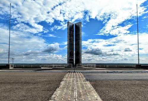
I was still a bit nervous about going across the dam over into Mexico. From what I had looked up it seemed like it would be a fairly easy adventure out to the memorial and back. But the fact that I didn't have a passport, just my drivers license, and the fact that it was the most dangerous section of the border with illegal crossings and drug trafficking, kept me hesitant.

Since my anxieties were already high, I skipped the first cache there by the U.S. Border Patrol and Immigration checkpoint. Not being a very busy crossing, I felt as though they'd all be watching me as I'm wandering around looking for some hidden object.

I drove to the gate and was stopped by a green uniformed Border Patrol agent. Explaining that I didn't have a passport, just my Florida drivers license, and that all I wanted to do was go halfway across the dam to take pictures of the memorial and the views... the big question... WOULD THEY LET ME BACK IN! He just kinda grinned and said that "he had no problem with it. But the guys in blue from Immigration on the return side might have some questions."

Officially called the International Falcon Reservoir, it is located on the Rio Grande east of Zapata. The huge lake is bounded by Starr and Zapata counties, Texas, and the county and city of Nuevo Ciudad Guerrero, Tamaulipas, Mexico. The dam and reservoir provide for water conservation, flood control, hydroelectric energy, and recreation. The project is owned, authorized, and operated by the United States and Mexico through the International Boundary and Water Commission. The project is named for the relocated town of Falcon.


The idea of a dam six miles east of the present site began about 1935, and the lake was approved by treaty at its present location in the late 1940's. Work began in 1951, and deliberate impoundment started on August 25, 1953. The reservoir was dedicated by presidents Dwight D. Eisenhower and Adolfo Ruiz Cortines on October 19, 1953. The five-mile-long rolled earthfill and concrete embankment was completed on April 8, 1954. The first power was generated commercially on October 11, 1954. The dam is 150 feet above the riverbed, with a crest elevation of 323 feet above sea level. Almost two miles of the dam is in the United States, and nearly three miles is in Mexico. The cost of the lake to the United States was $35 million. Flood-control benefits to the United States had totaled $130 million by January 1, 1986.


All lands on the United States side, except for Falcon State Park, are privately owned above 307 feet. The area of the lake varies from 87,000 acres at elevation 301.2 feet to 115,400 acres at the maximum elevation of 314.2 feet. The reservoir has a summer storage capacity of 2,371,220 acre-feet.

Each country has three 14,750-horsepower turbines running three 10,500-kilowatt generators at each plant. Four units are possible if needed. Under terms of the treaty the United States receives 58.6 percent of the conservation storage and Mexico 41.4 percent; financing of the project was based on the same percentages. The drainage area above the dam is 164,482 square miles; 87,760 is in the United States and 76,722 in Mexico. The United States side provides nine public access areas, including the dam itself, along which runs a two-lane highway connecting Farm Road 2098 and Mexican Highway 2.

I found this really cool website with more information about the history of the area, the building of the dam, and the archaeology of the settlements during construction as well as during a drought in the 1990's that had exposed many of the homes and churches that had been underwater for 40 years.


In the photo above, I am near the geocache (GC1N6HD) location in Mexico looking back towards the United States. After spending about 30 minutes out there enjoying the scenery, taking photos, and getting a new country for geocaching, I figured I'd better get back to Texas. But first... WOHOO!! Now I have found geocaches in 5 countries: the United States, Canada, Greece, Germany, and now Mexico!

So I pull back up to the checkpoint on the United States return side. Out steps the man in the blue Immigration and Customs Enforcement uniform, better known as I.C.E. After handing him my drivers license and he begins to ask some questions. I explained that I just wanted to get some photos of the monument and from the dam. I told him that I didn't go nor did I have any interest in going through the Mexican checkpoint. He asked about what brought me here from Florida and I told him I was working on the new wind farm that was beginning construction just up the road. He found that interesting and we talked about that for another few minutes until another vehicle finally pulled up behind me. Said goodbye and returned back to the motherland safely!

That's it for today. Hopefully you didn't get bored with all the rich history I included in the text. If you like that sort of thing, please let me know. Leave your comments below or subscribe to this blog with the button on the right. You can also follow me on Facebook, Twitter, Reddit, Instagram, and now Parler. Looking forward to your comments and letting me know you're out there.

See you next time...

Sunday, September 6, 2020

2018-09-03: Geocaching Through South Texas History From The Alamo to the Rio Grande Valley

Hello and welcome back to another recap of AwayWeGo's Geocaching and Exploring Adventures. On this Labor Day Monday, I drove down from Killeen in Central Texas to Falcon Lake in the Rio Grande Valley. There were a lot of new places to see, so let me get started.

After nearly an hour of driving, I made a stop in south Austin for gas, Dunkin Donuts, and a quick urban geocache (GC79YHY).

From there I proceeded down to San Marcos in the next county over. Hays County was founded in 1848. The courthouse building isn't the first one in the county. The current one was built in 1909. I can't say too much more about it because it's a virtual geocache (GCG9JY) and I don't want to give away any answers.


The next county to the south is Guadalupe County. There I found another virtual geocache (GCGAQQ) in the town of Seguin. That took me to a house called Sebastopol. This Greek Revival house was built in 1854-56, with reinforced load bearing walls of cast-in-place limecrete, an early form of concrete made of lime, sand, and gravel. One of many concrete structures built in Seguin, this is an important surviving example of early concrete technology in the southwest.


Not too far away was the Juan Nepomuceno Seguin gravesite (GC6YTN1) for whom the city was named. Born in 1806, Juan assembled Mexican Texan troops and fought in the 1835 Siege of Bexar. He provided horses and aid for troops of Col. William B. Travis. Further aiding as courier during siege of the Alamo. Juan Seguin commanded Company A Cavalry 2nd Regiment during San Jacinto victory and pursuit of the Mexican Army remnants following San Jacinto battle. After a career in politics, Juan Seguin died in 1890 in Nuevo Laredo, Mexico. His remains were returned to Seguin.


Moving on down to Karnes County, I arrive at my next geocache (GC4K1MF). The second Polish colony in Karnes County, the village in this area grew out of a small settlement known as St. Joe and was formally established in 1873. At times the priest at Panna Maria would conduct services at St. Joseph School in what would become Czestochowa. The "Mother Colony" church at Panna Maria was destroyed by lightning in 1877; Czestochowa settlers decided to build their own church. This was the subject of much controversy among the Polish pioneers of Karnes County. Anton Jarzombek (1836-1922) and Frank Mutz (1814-1891) each donated land for the church. Area residents contributed their labor to build the eighty-five by forty foot church with Gervase Gabrysch (1830-1904) as contractor.


Bishop Anthony D. Pellicer blessed the church on February 10, 1878. Father W. Pelczar was assigned as the first pastor that September. As a sign of their reconciliation, the parishioners from the newly rebuilt Panna Maria church presented the new parish a large painting of the Virgin Mary of Czestochowa, the Patroness of Poland. The two congregations often shared leadership in the ensuing years. The Cestohowa church (adopting the Americanized spelling of the community) thrived into the 20th century.

In the 1930's the church underwent intensive additions and remodeling. Though the original walls remained, the roof was completely removed and the ceiling raised. The north and south wings were added and the steeple was increased in height. In 1998, the church celebrated its 125th anniversary. At that time, the parish consisted of 380 members. The Nativity of the Blessed Virgin Mary Church continues in the traditions of its founders.


Bee County was next on my list. I drove down to this town called Normanna, Texas. The area had been a Mexican land grant back in 1831. In 1874 it was named Walton Station after Sheriff D.A.T. Walton.

Norwegian immigrants moved into the area in 1893, and formed the nucleus of their colony just 2 miles from Walton. When the postal authorities rejected the application for a post office under the name Walton, Normanna was submitted and accepted. The name loosely translates as "the place of Norsemen" but closer to the true meaning is "far North." Seeing that's where they were from, the name was appropriate.

Families descended from the original Norwegian settlers still live in the area. Normanna has a museum in a building that has served as ranch headquarters, a hotel and a residence. The town thrived for years, but then declined after a series of fires and the advent of the automobile. This is that building today.


The geocache (GC10AXF) was located on the west side of town at the Medio Creek Bridge. The bridge was the idea of Viggo Kohler, a man who later built the large Viggo Hotel in Hebbronville (1915). He petitioned the Bee County Commissioners to accept bids in June of 1897. The bridge arrived in kit form and was assembled by the Austin Brothers Bridge Company. It has long since been decommissioned and slowly being reclaimed by nature.


Continuing south into the town of San Patricio, Texas, I went to my next geocache at the Old Cemetery On The Hill (GCMDMV). This cemetery is believed to have been used for generations by Indian tribes and Mexican settlers who lived in this area previous to Anglo colonization. Following the establishment of San Patricio de Hibernia in , the colonists continued to use the old cemetery on the hill.


According to local oral tradition, early graves in the cemetery were marked by wooden crosses and stones bearing Spanish and English inscriptions. Among those interred here are Lt. Marcelino Garcia who was killed at the Battle of Lipantitlan in 1835. Also buried here are soldiers who died in the Battle of San Patricio on February 27, 1836; James McGloin, who's grave was never marked; victims of diseases such as scarlet fever; men killed fighting duels; and many early settlers and their descendants.

After a new cemetery was consecrated at San Patricio in 1872 (GC6C4ZE), the Old Cemetery on the Hill was used infrequently. The old cemetery was neglected for many years until restoration efforts were begun in the 1960's. Some tombstones where lost or destroyed over the years. But the historic graveyard is now maintained.


Passing through the town of Bluntzer, I saw this old schoolhouse. The first Spanish land grant awarded in what is now Nueces County was the Casa Blanca Land Grant. Granted in 1798 by the Spanish government to Juan Jose de la Garza Montemayor (1765-1816) and his three sons, Juan Manuel, Jose Perfecto, and Jose Agustin, it was located between Penitas Creek and the Nueces River. Originally called Penitas Grant, it consisted of 70,848 acres, or sixteen sitios of land.

The school for the town was opened in the 1870's, but flooding by the hurricane of 1919 necessitated its relocation. Justina Bluntzer, daughter of Nicholas, donated the land for the school. This final school building was constructed in 1939. The school held classes until it was consolidated with the Banquete ISD in 1971.


My next geocache was at the Cemeterio De La Luz (GC1CXD6). I couldn't find any information on this cemetery other than there's over 350 burials here dating back to 1926.


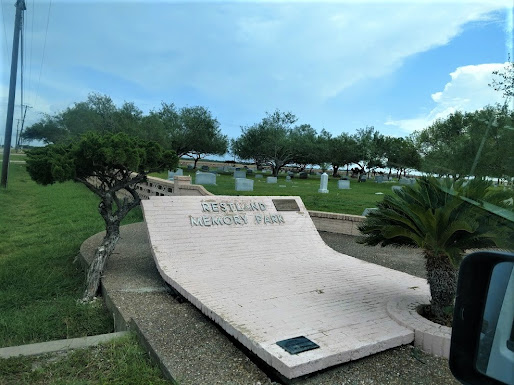
Still working my way south, I stop at the Restland Memorial Park cemetery for my next two geocaches (GC2N9WG, GC7TGWT). Located in Bishop, Texas, the town was established in 1910 by F. Z. Bishop on land he had purchased from the Driscoll Ranch. A businessman from Corpus Christi, Bishop dreamed of building a model town on the prairie. He planned, designed, and managed the construction of the townsite. He died in 1950 and was buried in Restland Memorial Park.


My final geocaching stop brought me to the Pedro Garza Zamaora Cemetery (GC23ZNM). There's only 140+ burials dating back to 1904. This row of statues stood out the most.


Well that's it for this days adventure. There's a lot of South Texas / Mexican history to be learned on this drive. We'll be discovering that over the next few months while I work on this new wind project. Until next time, happy caching!