Showing posts with label San Angelo. Show all posts

Saturday, January 4, 2020

2018-04-01: Geocaching Through Texas Ghost Towns, Cemeteries, Backroads, and a Large Frog

It's that time again. Another 360+ mile Sunday drive from Killeen to Monahans in West Texas. That means more Geocaching to break up the long drive. So let's get started...

My first stop was in downtown Lampasas at a Geocache called "What's with all the puppets?" (GCJC9Z). It was located out on the front sidewalk of this German Restaurant. Inside the restaurant are a bunch of those Marionette puppets hanging from the ceiling, but the place was closed on a Sunday morning so I couldn't enter.

Then I drove to the south side of town and arrived at the Santa Fe Center (GC15R9R). Located inside the shopping center parking lot just happens to be the oldest cemetery in Lampasas County. The Cook Cemetery was established as a pioneer community graveyard in the mid-1850's. The first marked burial here was that of Rebecca Hughes in 1854. The cemetery is named after Arkansas natives William M. and Cynthia Cook who moved to Texas about 1856 and bought the land containing this graveyard in 1861. No recorded burials occurred here after that of J. S. Brown (d.1873) due, it is believed, to major flooding here in 1873. The cemetery has been altered by highway and business development. It was deeded to the Lampasas County Historical Commission in 1978.


Making up some ground, I continue all the way through Brady where I pick up US-87 west towards San Angelo. On US-87 I find my next two geocaches near the ghost town of Pasche, Texas (GC1NVHZ, GC1JH0X). The Pasche community had a post office from 1907 until sometime after 1930. In 1908 promotional literature for the county cited Pasche as one of five Concho communities having a windmill. Pasche became a station on the Gulf, Colorado and Santa Fe Railway sometime around 1912, when a line was completed from Lometa (Lampasas County) westward to Eden.

In 1914 Pasche had one gin, two general stores, and a population of fifty. From 1925 until 1967, the last year for which a figure is available, Pasche reported a population of twenty-five. In 1936 the community had a school, a church, and a seasonal industry. In 1940 the school, which encompassed grades one through seven, had two teachers and an average daily attendance of eighteen. By 1955 the Pasche school had been consolidated with the Melvin (McCulloch County) school district. By 1970 only a few scattered buildings remained in the vicinity. The only thing I saw were a couple of farm houses.

Driving several miles west on County Road 3034, I arrived at Sudduth Cemetery (GC1NVJ2). The Sudduth Family Cemetery contains only four graves ranging from 1917 to 1945. I couldn't find anything else on this family or the neglected cemetery.


Getting closer to San Angelo, in the small community of Vancourt, I found my next cache (GC130FX). Vancourt is a farming and ranching community on U.S. Highway 87 twenty miles southeast of San Angelo in Tom Green County. In 1908 the community postmaster estimated the Vancourt population as 125. The first business at the community was a stage stop run by William C. and Ida Dickey 1½ miles east of the present site of Vancourt. W. S. Kelly, establishing a mail route for the El Paso Mail Company, applied for the first post office. He named it in honor of his new bride, Mary Ann Van Court.

In 1908 Calvin J. York, Jr., built a general store on the north side of the highway. Until it closed in the 1970's, it remained the only store in the community. The White Swan School, originally 1½ miles northwest of Vancourt, was moved to the community in 1907, on the south side of U.S. Highway 87. The Works Progress Administration in 1937 built a new brick schoolhouse that was used until 1940 (pictured below). A cotton gin had been built in the 1920's west of the school site; the gin continued to operate in the same location in 1988. At that time, businesses in the area near the townsite included another cotton gin, a mill, and two grain-elevator companies.


My next one in San Angelo gave me a bit of a chuckle. My Froggy Friend (GC6Q49M) was made from used tires and located outside a tire shop.


My final five geocaches were quick roadside stops along US-87 between San Angelo and Sterling City. They were: Roll out the Barrel (GC1Y1W7), Body Snatchers (GC1Y2JV), Flying Lone Star (GC513QK), EZMLT (GC5BKYX), and Johnny's Cache (GC5QR80).

That's it for today. Thanks for stopping by. Be sure to follow me by going to  FacebookTwitter, or Instagram. Feel free to share my stories with your friends as well. Until next time...

Thursday, December 19, 2019

2018-03-11: Ghost Towns, Cemetery, a Gadget Geocache and More

Well here I go again. Another Sunday and another long drive back to West Texas. With some Geocaching stops along the way to break up the 360+ mile drive. Getting a little bit of a later start, I didn't want to get side tracked and spending a lot of time geocaching close to Killeen. So upon leaving home, I drove non-stop to San Angelo where I make my first stop at Starbucks.

Then heading SW on US-67 a few miles down the road by the Twin Buttes Reservoir, I make my first Geocaching stop at "A Little Bit of Sprinkles in San Angelo" (GC5BPYX). After a little bit of a search I came up empty. This one hadn't been found in nearly two years and had several DNF's. And now I've also added my DNF.

Just down the road was another cache called "Burt's Bees" (GC3XXXE) that previous finders also couldn't find. One of which said there was a damaged container. So I gave it a look because it had a few favorite points. Sure enough, I found what was left of a damaged container and nothing else. So I logged my 2nd DNF of the day and a "Needs Maintenance." Uggh! 0-2 is not a good way to start the day.

Back on US-67 a little ways and I get the smiles again. I guess you could call this one an easy gadget cache or just a very creative geocache. Called "Hickory Dickory Dock" (GC6Q5QC), it's just one of those fun creative caches that someone put some thought into.


Then I found the nearby "Old House Gone" geocache (GC11J8E). I'm not exactly sure about the real history here. I don't think it was once a real house now gone. But it looked more like an urban outdoorsman camp. There was the remains of a mattress (just the metal springs), an old couch, and lots of old rusty tin cans scattered about.

One more quick geocache "To the Ramp and River" (GC1B6RP) around the Twin Buttes Lake area and I'm finally moving westbound again.

The next two geocaches on my list were for the Arden Community ghost town (GC113HK, GCMJ22). Arden, on Rocky Creek was named for John and Katie Arden, who settled a claim at the site by 1885. The community acquired a post office in 1890 with W.P. Moore as postmaster. A local public school was established in 1892. Two short-lived schools had operated before this in Arden district, one on Rocky Creek and the other at Sawyer. In 1915 Arden had a post office, a school, a church, and a population of fourteen. In 1947, when the community had one business and thirty residents, the Arden School was consolidated with the Mertzon. All of the businesses had been abandoned as of 1966, execept for a polling place used to preserve precinct lines. The passing of the school, low cotton prices, drought, and better opportunities in nearby larger towns were the primary causes for the decline of Arden. The 2000 census listed only one resident remaining. Since 1952 an Arden reunion has been held each Labor Day on Rocky Creek.


The photo above is where the school used to sit. The photo below is of the Arden Cemetery which contains just 44 burials and is still in use to this day.


In trying to make my way back to US-67, I passed by "Middle Concho Crossing" (GCMN76). A low water crossing for a creek but it was dry here today. That one was followed by another "Just Over the Hill" (GC11KTE).

Passing through Mertzon for a few miles to the south I arrived at the ghost town of Noelke (GC15Y5N). From the cache page: "Noelke is on the Atchison, Topeka, and Santa Fe Railroad and a local road ten miles southwest of Mertzon in south central Irion County. The small settlement began as Monument Switch on the Kansas City, Mexico and Orient Railway when the road built through the area in 1910. The community was renamed Noelke in 1933 in honor of a local ranch owner, Walter Montgomery Noelke. The Monument switch continued in service in Noelke for some time after that, but county maps of the 1980s show only the location of the Noelke community. According to a local resident there was never a town here. Locally it was known as Noelke Switch. The Monument name came from a nearby mountain of the same name. The only building he was aware of was the railroad man's home which is gone. Old cattle pens are all that remain as this was the main place in the area for loading cattle for transport. Today trains pass through the area about twice a week on their way to Alpine. The ranch land for miles around is still owned by the Noelke family."


Around the curve a few miles away was my last stop and another ghost town called Pumpkin Center (GC15Y5Q). Again from the cache page: "According to a local resident, Pumpkin Center consisted of a store where area residents could get basic supplies and pick up mail. It was located at the junction of two county roads and along the Atchison, Topeka, and Santa Fe Railroad. The railroad switch at this spot was known as Suggs Switch. Nothing remains at the location. With the establishment of Mertzon, Pumpkin Center ceased to be."

That's it for me today. Still had 140 miles to go from here. Better get moving cause it's getting late in the afternoon. I hope you enjoyed the ride. See you next week...

Monday, November 21, 2016

2016-10-22: A Train Depot, an Old Fort, and Dinner With Other Geocachers!

Hello again and welcome back to another day in our Geocaching Adventures. Today we're heading down to San Angelo for a Geocaching Event hosted by a cacher named mommio. Though it started with brunch, we didn't make it in time for that. We grabbed a few caches on the way and then cached around San Angelo before meeting up with everyone at dinner. But I'm getting ahead of myself.

Our first stop of course was the Starbucks in Odessa. Then on to Midland taking the TX158 exit east over to US-87 south towards San Angelo.

Our first Geocache was at the Water Valley Cemetery (GC13P18). The small community of Water Valley, TX dates back to the mid-1800's. The oldest marked graves date to the 1890's, though there are more than a dozen unknown grave sites.


A few miles down the road there's a historical marker and our next cache (GC1XXZ6). In 1911, the Texas Legislature passed a law calling for the establishment of state institutions for the treatment of tuberculosis. Across the street from the historical marker was the first such establishment. Opening in 1912, the Anti-Tuberculosis Colony No. 1 began with facilities for 57 patients on a 330 acre tract of land. The tuberculosis nursing school was founded here in 1915, and by 1961 had graduated more than 500 nurses. It was renamed the State Sanatorium in 1919. Because of the advances in medicine, it eventually closed in 1971 after treating 50,000 adults and 5,000 children.

Not too far away is the small town of Carlsbad, TX. The town began in 1907 and soon began growing. But between a three year drought followed by the lengthy depression, the population declined. Our next Geocache (GC1XY0W) brought us to this old bank building, probably built in the early 1920's. It would be interesting to see this structure restored. The walls seemed pretty sound. The roof and interior have fallen apart. But to leave the look of the exterior, upgrade and modernize the interior and you'd have a cool looking house.

We finally made it to mommio's house and the other cachers have already scattered about town to do some local Geocaching. We found the rather LARGE geocache on the front porch (GC1F8K8) before moving on around town ourselves.

The next few caches were a couple of fun simple gadget caches. Pinball Wizard (GC217N6) was one that we've found several of before. Think like pulling the plunger on a pinball machine to get the ball (cache) to shoot out. That was followed by Puff the Magic Dragon (GC214PD) where you had to blow into a tube to get the cache to pop out the top. Three Blind Mice (GC6Q2Q5) was up next followed by Twist and Shout (GC33RDA).

From there we drove over to The Cowboy (GC4RW35). It was a statue honoring the hard working ranchers in West Texas. We never did find the cache. Turns out it was missing.


We also spotted these wonderful murals on the side of a building highlighting early public transportation in San Angelo.


I finally decided to go over to get the cache located at the San Angelo Visitors Bureau (GC101N0). I figured while there we could also find out some of the more interesting and historical places in town. There we picked up some information on the train depot and the old fort. Since the train depot was closest, we headed over there first.

Train service first arrived in San Angelo in 1888 by the Gulf & Colorado Railroad, which was soon after purchased by the Santa Fe Railroad. But in 1900, the Kansas City, Mexico, & Orient Railroad also built a line through San Angelo. The depot here is the KCM&O depot built in 1910 and serves today as the Railroad Museum.
With the two competing railroads, San Angelo became the most important sheep, goat, and cattle shipping station in the country. The Santa Fe Railroad Company bought the KCM&O in 1928 after the oil boom. But in the 1950's passenger rail service began to dry up with the construction of new roads and highways. And on June 20, 1965, the last train departed from the depot.

After touring the train depot and viewing all the displays, we drove over to Fort Concho. The center of a line of forts extending from the northeastern border of Texas to El Paso, Fort Concho was also the northern point of southern chain of forts extending to the Rio Grande. Established in 1867 (at the junction of the Butterfield Trail, Goodnight Trail, and the road to San Antonio) by 4th Calvary under Captain George G. Huntt to protect the frontier.

By March 1, 1870, the fort buildings were a commissary and quartermaster storehouse, hospital, five officers quarters, a magazine and two barracks; all built of sandstone. On June 20, 1889, the fort was abandoned and the property passed into private ownership.

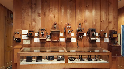
We toured through all the restored buildings and looked at the displays. One of the officers quarters was even made into a telephone museum where they had just about every type of phone ever made! There were also two caches there, well supposed to be two caches there. We found one (GC46FQX) but not the other (GCKX8T).


By now it was time to meet up with the group at the restaurant for dinner and talk of our Geocaching tales of the day. We had a good time meeting a lot of new cachers as well as seeing some familiar faces from other events.

There's a lot more to see around San Angelo, but as usual they'll have to wait another day. We just need to retire early! Until next time, see you back here or out on the caching trails.