Showing posts with label Midland. Show all posts

Saturday, November 16, 2019

2017-12-27: Surprise Road Trip Killeen, Texas to Baltimore, Maryland Day 1

My Wife has a Big Heart and I Love Her Very Much! She's always willing to put others needs before her own. Being a therapist in a nursing home facility is almost like being in the medical profession. Wait, it is a medical profession. What I mean is that the only holidays she gets off is when it falls on the weekend. Fortunately this year, she is between facilities. The new Director has taken over where she was in West Texas but the new facility in Killeen hasn't opened yet. That's why her company has been using her to train others.

My job has shut down for a week and a half for the Christmas / New Years holidays. So we had the entire time off together. NOT SO FAST! She got a call begging her to help at a facility in Midland to cover on Monday, Christmas Day as well as Tuesday the 26th. Her big heart and willingness to help says OK. We'll still have a whole week at the house in Killeen for a vacation.

So yesterday we decided I would take her to work in Midland and drop her off before going back to the apartment in Monahans. There I would finish packing, load up the dogs, pick her back up after a few hours, and continue east towards Killeen. NOT SO FAST!! Just before I picked her up, her boss called to say they're sending her to Baltimore for two weeks to train some more directors there. Oh, and her flight leaves in a few hours! So back to Monahans, repack with scrubs for work, and back to the airport in Midland. I guess it's just me and the dogs for the next week.


Well on the remaining four hour drive to Killeen, I was feeling sad and depressed about our vacation vanishing. But then it hit me! I got a whole week! I'll stay the night in Killeen, but continue driving to Baltimore and surprise my Sweet Wife! I can get there and back in a week easy. So last night I called the hotel she was staying at to see if they allow small dogs but they said no. There was one nearby that did though. But I'll deal with that when I get there.

I also started looking at the route to get there and back. Can't do a road trip without getting a few Geocaches. Especially in the counties I still needed. So this morning I woke up early with excitement, grabbed the dogs, and out the door I went!

My first stop was Italy! Well Italy, TX that is. Nearly 2 hours and just over a hundred miles, I figured this virtual cache right off of I-35E would be a good place to walk the dogs too. Unique Italian Architecture (GCC25B) can be viewed from the Interstate while passing by, but then you can't see all the unique buildings. This is a warehouse made to look like a caterpillar, but the company makes dome shaped houses. There's a whole domed house neighborhood right here too. After a few pics and the dogs taking care of business, back on the road again!


Another two hours and another 120 miles later, I stopped for another quick cache (GC26HV9) right off the exit on I-30 in Sulphur Springs, Texas. This got me a new county, Hopkins County, and the dogs got to do their business as well.

Just 40 miles east on I-30 was Morris County and another quick highway exit cache (GC384YY).

My last Texas stop for today was just 24 miles later in Bowie County at the New Boston Cemetery (GC15NGJ). New Boston was established in 1877 as the result of the railroad being built just four miles to the north of Old Boston in 1876. Didn't spend a lot of time here. Gotta keep moving.


Welcome to Arkansas! Thirty miles later I pull into the Arkansas Welcome Center to grab a cache for Miller County (GC27RNF).

Ten miles later a quick exit park and grab cache (GC4KKN3) near a roadside memorial for three accident fatalities and one for Hempstead County.

Twenty-seven miles after that and I arrive in Nevada County, Arkansas for my next needed county. I chose this cache called The Battle of Gum Grove (GC18ZWR) because it was close to the exit and it had a Civil War history. Officially known as the Battle of Prairie D'Ane (French for Donkey Meadow), it was an open prairie 20 square miles surrounded by dense forest. Having taken place April 9-13, 1864, it was part of the Camden Expedition launched by Union Forces to drive the Confederates down into Texas, which it was unsuccessful in doing so. The cache was placed near an abandoned railroad overpass of I-30 which overlooked the battlefield prairie. Not really much to see related to the battle.

But what I did take a liking to and another reason why I like Geocaching, is finding the old abandoned railroad overpass. I took several different photos and I think I liked these two best and couldn't decide which one to share with you. So I decided to share them both.


OK, after the dogs and I have checked out the bridge enough, I load them back into the car and we hit the road again.

Compared to these previous short drives, this next one was a long 72 miles down the road. I arrived in Saline County in a town called Benton, Arkansas. The cache itself was fairly easy to find, but it was a Challenge Cache. A Challenge Cache is one that has requirements beyond finding it and signing the logsheet. This particular one is called "5 State in a Day Challenge" (GC5FB8A). I think you can guess as to the requirement needed. Well I met that requirement back nearly two years ago on another road trip: "870 Miles, 6 Geocaches, 5 States, 1 Day", when I found a cache in Texas, Louisiana, Mississippi, Alabama, and Florida all in the same day.

Twenty miles up the road and I'm now in Pulaski County and Little Rock, Arkansas. There's several good Challenge Caches here that I qualify for, but being pressed for time I had to choose just one. I ended up picking the Arkansas Bakers Dozen Challenge cache (GC395QZ) because I also needed its Difficulty/Terrain rating. It had a D/T rating of 5/2.5 of which I used to have a blank space on my grid. To understand the Bakers Dozen requirements, click on the GC# link and there's a detailed breakdown on the requirements.

Another short 20 miles later and I arrive for a quick exit cache (GC7G6CG) in Lonoke County.

I drove another 50 miles before calling it a night and checking into a hotel in Brinkley, Arkansas. A total of 538 miles today with plenty more to go. My wife still has no clue I'm coming. When we talked on the phone a little while ago, I was somewhere down in South Texas geocaching and picking up the needed caches down there. Gonna be a big surprise in Baltimore! Be sure to check back in tomorrow for more...

Wednesday, November 13, 2019

2017-12-10: Geocaching Cemeteries, a Ghost Town, a Power Run, and More Around West Texas.

Well it started out a sad morning. I had to drop my wife off at the airport this morning in Midland, Texas. She had to take a business trip up to Boston, Massachusetts for a week to train a Director of Therapy at a nursing home there.

So I went geocaching solo today. I didn't go far, just taking the long way and backroads to Monahans. I drove north out of Midland-Odessa on US-385 to grab my first cache at a picnic area (GC2KBRC). It would have been a quick park and grab, but there was this old wind mill there with this hawk or falcon sitting up on it. I probably spent about 15 minutes trying to get a decent picture. But you can only do so much with an old phone camera. I couldn't really get a closeup shot of the bird itself. It just made me miss my old Nikon. Gotta get a new camera one of these days.


Finally I decided enough photos have been attempted and continued north a few more miles. I arrived at a geocache called November 24 (GC3B1RT). It is one of a series of Power Run caches scattered about Midland and Odessa named for each day of the year. Along this stretch of road, I managed to get another 19 of 22 of the calendar dates. There were three along this road that I could not find. 

Looping back around to the south on Farm Road 181 and about 4 miles west of Goldsmith, I came to this intersection. On the one side out in the fields are these old buildings. Couple houses maybe? I'm not sure. I couldn't find any information on them. If you know what they were, please comments below. On the other corner is an active business. The Pioneer Cafe looks to be a combination cafe and convenience store. Though it was closed today so I'm not sure.


So I made my way back to Monahans and stopped by the Monahans Cemetery. I hid a cache there last year (GC6X29H). It had gone missing so I made a new one and replaced it today.

Instead of going home, I decided to continue heading west. There was a new cache listed in Pecos and the FTF (First to Find) was still up for grabs. Instead of jumping back onto I-20 so quickly, I decided to take the Old US-80/TX-57 highway westbound for the scenic drive and to see what's there. It goes through Thortonville, then Wickett, and into Pyote. Just before you get into Pyote on the east side of town was this small cemetery. There wasn't a cache here but I checked it out anyway. Hmmm I don't have a cache container with me so I'll have to bring one back and hide it here.


Continuing on into Pecos, I arrived at the roadside picnic area north of town where the cache (GC7FVHA) is supposed to be hidden. Looked and looked where the coordinates lead me to but no luck. Then I spend another 20-30 minutes looking based on the cache name and hint. Nope! Finally after about an hour I give up and log a DNF. Maybe next time.

Well while I'm here, I might as well get a couple others in town. This next cache (GC6XM70) was outside a restaurant. Fortunately small town Texas means closed on a late Sunday afternoon. So no muggles made it easier to find.

Another stop by the cemetery here on the south side of town without a cache. This one was kinda divided into three sections. The main cemetery which was neat, orderly, and lined up like you would expect a cemetery to be. Another section which was also normal. But in between the two was a spare section with a few scattered headstones from the 1800's. Some out in the open and near the dirt drive path that could be easily driven over if you weren't paying attention. Either way, another spot to hide a cache at soon!


Well that's it for now. Back to the lonely apartment without my better half. Well me and the Chihuahuas anyway. Until next time...

Saturday, August 13, 2016

2016-07-24: West Texas Ghost Towns, Cemeteries, an Old Church, and a War Memorial

Hello again. Today's Geocaching Adventure takes us to several cemeteries, ghost towns, a Vietnam war memorial, and some more sights around West Texas. So we're glad you stopped by. So buckle up and let's begin.

After a Starbucks stop in Odessa, we head just north to a small town called Gardendale for our next two caches GC4KKDB and GC34VGJ. The second one brought us to this Mystery Mansion. According to the cache page, a man began building this house in 1950 but never finished it. For a long time he lived in a small travel trailer along side it. Inside the house are stairs that lead up to nowhere, doors that open to brick walls. Kinda reminds me of the Winchester Mansion in California. A mystery for sure.


Heading back down between Odessa and Midland near the airport is a virtual cache. For those of you reading about our adventures who are not familiar with Geocaching, a virtual cache is one that doesn't have an actual container with a log sheet. In order to claim a find you must visit the cache location and find the required answers listed within the cache description.

This particular virtual Geocache (GCE131) brings us to a Vietnam War Memorial honoring the Odessa and Midland residences who gave all for the freedom of others.


Back on the I-20 highway westbound, we make it down the road to Stanton, TX and our next Geocache (GC1MZF0). With the purpose of founding a monastery and a German Catholic Colony, Carmelite Monks, in 1881, began the first catholic church between Fort Worth and El Paso. The adobe and brick monastery was completed in 1884, and St. Joseph's Church in 1885. Sisters of divine providence opened a short-lived school, 1887; reopened, 1894, by Sisters of Mercy. In 1897, Carmelite Monks disbanded and sold property to Sisters of Mercy, who operated a convent and academy until abandonment after a tornado severely damaged the facilities on June 11, 1938. All that remains are a dormitory, ruins of other buildings, and the cemetery.

While passing through the center of Stanton, we passed by what looked like an old Ford dealership. I didn't see a parking lot full of cars for sale, just an old building which appeared to be a showroom and offices. Because of the glare on the plate glass windows it was hard to get any decent photos, but there was an old Model A sedan and a 49 Ford along with a new model.


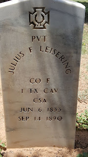
Driving south out of Stanton, we head to Evergreen Cemetery on the southern end of town for our next couple of caches. (GC2V38B & GC31QVK) I don't know much on the history of this cemetery, but one of the oldest headstones I saw was that of Pvt Julius F Leisering who died on September 14, 1890.


A few more caches later and we're driving south from Big Spring, TX on US-87 to our next Geocache (GC1JHNM). Another cool thing about Geocaching is even though you've found a great spot to hide a cache, you may not know its history. But eventually you may come across another Geocacher who does know the story behind your mystery.

That's the case with our next cache. The CO had driven by this place several times and even stopped to look for clues. But could not find out what this place was. However it was still interesting enough to hide a cache here and called it "History's Mysteries." Well five years later another cacher was here to make the find and had the story from a cousin who grew up and still lives down the road. At one time this road and Overton road were the San Angelo highway. The building was a gas station.

A few miles further south and east we find our next two Geocaches (GC3QB8Z & GC1JHMN) for another Texas ghost town. Hyman was on Farm Road 2183 twenty-seven miles southwest of Colorado City in southwestern Mitchell County. It was the site of the last school district to be organized in the county, in 1923 and was named after Mr. and Mrs. Harry Hyman, who donated the school lot. By 1930 eighty students were enrolled from the district, which covered eighty-four square miles. A post office was established at the community in September 1924 with Sarah M. Hyman as postmistress; it stayed open until around 1947, when the town reported two businesses and fifty residents. In 1945 the local school district was broken up and divided by the Colorado City, Westbrook, and Forsan schools. Hyman was the site of a radio navigation station for military aviation. The station was decommissioned with the closing of Webb Air Force Base in Big Spring. In 2000 three families still lived in the community, and the abandoned navigation station, a cemetery, and the ruins of a church remained at the Hyman townsite.


While the last cemetery may be somewhat forgotten and neglected, this next one has an interesting story behind it. Our next Geocache (GC29137) took us to an unknown cemetery of unknown graves. Not too many feet to the right of this photo is an oil well and many more in the surrounding field. The oil field workers discovered these graves, took some of their piping and created a makeshift fence. They try to keep the site maintained as they come to inspect the oil pumps and pipelines.

The story of the graves is that an old stagecoach trail passed through this area. The two theories are a woman and three children or a woman, two children and a dog. Also unknown is how they died. Could it have been Comanche Indians, stagecoach robbers, or perhaps they tried a homestead but failed. We may never know.

Just some sunflowers along the way.
Our final two Geocaches (GC1J0D5 & GC1H3ZW) for the day brought us to the Coahoma Cemetery. Coahoma, Texas, on I-20 ten miles northeast of Big Spring in east central Howard County, probably took its name from Coahoma County, Mississippi, which in turn derived its name from an Indian word meaning "red panther." Early names for the community included Signal Mountain and Signal Mountain Station, after a nearby hill. 


After the 1881 arrival of the Texas and Pacific Railway in the area, Coahoma grew into a retail trade center and shipping point. Its residents built their first school in 1891, and Gertrude McIntyre was the first teacher. By the time its second school was built in 1904, the town had a post office. Machinery and oilfield supplies became the most important goods distributed from Coahoma after the major oil strike of 1926. In 1928 the town had 600 residents, and its school district served 205 pupils. Between 1936 and 1956 the community's population rose from 620 to 802 and the number of commercially rated businesses went from eighteen to twenty-three. In 1960 the population was reported as 1,239, and in 1970 it was 2,000. In 1980 Coahoma had 1,069 residents. At that time the community also had twenty-four businesses, a bank, and a post office. In the early 1990s it was an incorporated community with a population of 1,157 and forty-eight rated businesses. In 2000 Coahoma had forty-eight businesses and a population of 932.

If you spend time looking through this small cemetary you might run accross one of its notorious residents. Texas outlaw Rube Boyce. He was well known in the region as a rustler and robber and was known to have killed at least three men. The El Paso stage followed the Northern San Antonio to El Paso National Road through Fredericksburg, Mason, Menard, and on to El Paso. The route crossed the San Saba River at Peg Leg Crossing, a few miles north of' London. Rube Boyce was adept, as well as habitual, at stopping and robbing the stage in a gap just west of Peg Leg Crossing. A stage driver on that run suggested that a scheduled stop be established in the gap to allow for Boyce's robberies so that the driver could keep the stage on schedule. As mentioned, stage robbing was not his only vice.


Well that was our Geocaching Adventure for today. Lot's of interesting sites and history learned for today. We hope you're enjoying our stories and will see you back soon.

Sunday, May 15, 2016

2016-04-03: A Presidential Geocaching Adventure, History and More Cemeteries

Today's Geocaching Adventure took us on a Presidential drive to a historical home. After a busy 6-day work week, it was good to get out and do some exploring. We decided to relax this time out instead of our recent hikes. Taking time for a good home cooked breakfast, we headed east on I-20 into Midland, Texas. Our first stop was a Starbucks since we haven't had one in a long while!

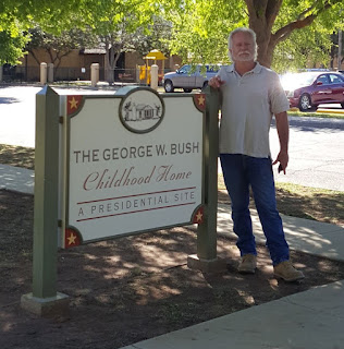
President George W. Bush childhood home.Our first Geocache was a Presidential Virtual! (GC89D4) The home of TWO Presidents! From the historical sign out front:

"George Herbert Walker Bush and wife Barbara came to Texas in 1948, moving to Midland with their young son George Walker Bush in 1950. They bought this house in 1951 and while here faced the loss of their daughter Robin and celebrated the birth of two sons. The years spent here were vital for young George, who attended Sam Houston Elementary, made lifelong friends and played baseball. The family moved to a larger home in 1955 and then later moved to Houston.

This c. 1939 traditional style house reflects transition from Tudor to Ranch detailing. Unique in history, it was home to two Presidents: George H. W. and George W. Bush; two Governors: George W. Bush (TX) and Jeb Bush (FL); and First Lady Barbara Bush."

However, while we were there it hadn't opened yet for the day. It was Sunday around 11:00 AM and we weren't up for waiting a couple of hours for an inside tour. Maybe next time we're in the area.

George W. Bush childhood home

Leaving the downtown presidential home, we continued east several miles outside the city of Midland to another of Texas' historical marker caches. This one was located near Midland County's first producing oil well (GC2A3Q4). There wasn't much to actually SEE at this spot, but here's what the historical marker reads:
The discovery of oil in the Permian Basin during the 1920's helped sustain the area economy during The Great Depression, and many oil and gas companies established headquarters in Midland. Not until the 1940's, though, did Midland County begin seeing its own productive wells. Geologist H. L. Beckman worked with the Rowan Drilling Company to stake out Humble Oil and Refining Company's No.1 Mrs. O.P. Buchanan oil well at this site. They spudded the well on September 14, 1944 and completed it on November 6, 1945 at a total depth of 12,574 feet. The well produced 332 barrels of oil in 29 hours and became Midland County's first producing oil well. It was plugged on August 1, 1947.
On the way to our next cache, we arrived in Garden City and the Glasscock County Courthouse and Jail. On May 9, 1893, a little over one month from the date of Glasscock County's formal organization, the first county commissioner's court issued bonds to erect a combination courthouse / jail buildings. The small 2-story structure was completed on February 12, 1894. Originally, the ground floor was used for court session and the 2nd story for the jail. On August 27, 1910, a larger building was completed and has been in continual use since 1910. The smaller building was then used entirely as the jail until a new one replaced it in 1980.

A few blocks away was the Garden City Cemetery and our next Geocache (GC30CB1). We couldn't get the cache located in the cemetery as there was a gardener mowing right near the cache location. The one we did find was located outside the cemetery near the entrance.

The next cache on the agenda was for another Texas ghost town (GC14VV1). Not much to see here except for the historical marker:
The pioneer settlement of Cummins developed at this site about 1890 around the saddle and harness shop of the earliest permanent settler, Mississippi native Robert Benjamin Cummins (b. 1848). A post office the following year the nearby town of Sterling City (1.9 miles east) was founded. The two towns became rivals for the designation of county seat when the Texas Legislature created Sterling County from Tom Green County on March 4, 1891. An intense publicity campaign developed, aided by the writings of the respective town newspaper editors: W. L. Thurman of the Cummins paper, the "North Concho News", and S. R. Ezzell of the "Sterling Courier". An election, conducted May 20, 1891, appeared to be a victory for Cummins until several voting boxes were dismissed for technical reasons, resulting in a tie. A second election on July 7 gave Sterling City a 13-vote margin and it was named the county seat. Most Cummins businesses and residents had moved to Sterling City by the end of 1891. Nothing remains of the early townsite, which once included a school, saloon, meat market, mercantile, blacksmith shop, and grocery stores.
Now that you know the story of the rivalry between Cummins and Sterling City, let's drive over to see what all the fuss was about. Arriving at the newer Sterling County Court House, you can still see the original 1912 County Jail building to the right of it. Like most of the old west jails we've seen, the lower level included living quarters for the sheriff and this one had seven jail cells on the upper floor.

Sterling County Courthouse and Jail

Across the street from the courthouse was this restored 1910 Hotel. Although I think the upper floors are still used as guest rooms or apartments, the lower floor appears to be an antique store.

Old Sterling City Hotel


A few blocks away was an old train depot. There wasn't a cache placed there, but I noticed the historical sign pointing the way to it and had to check it out. Attracted by the area's livestock production, nearby shipping points, and the financial support of the town, the Concho, San Saba & Llano Valley Railroad began building a line to Sterling City in 1909. A boxcar served as the depot until this mission revival building was completed. Highway and pipeline construction caused a decline in rail traffic and the line closed in 1958. Only this restored depot remains as a reminder of the early rail service that helped develop the area, and is now used as a community center.

Old Sterling City Train Depot

Our last cache here was at the Sterling City Cemetery (GC47QPH). Still in use today and well maintained. But a few miles down the road was another of the Texas ghost towns and the only thing that remains is the Montvale Cemetery (GC14PMK).
The community of Montvale was established in 1884 when the pioneer settlement of St. Elmo was relocated here. Then a part of Tom Green County, Montvale was located on the Shafter Military Trail, an early road from Fort Concho. A community school, the earliest in the area, was in operation by 1886. Three years later the town was platted by H. B. Tarver, the surveyor for Tom Green County. It is believed the settlement was named for a nearby hill referred to in Tarver's field notes as Mt. Vale. Early businesses in Montvale included the saddle and harness shop of R. B. Cummins and the general store and blacksmith shop of B. Z. Cooper. The town was also the site of a Methodist church, a hotel, a post office and a variety of stores. About 1889 R. B. Cummins started the town of Cummins (5.4 miles northwest) upriver from Montvale. Both settlements began to decline in 1891 with the establishment of Sterling City (3.5 miles northwest) as the seat of government for the newly created Sterling County. A community cemetery is all that remains of the townsite of Montvale, a pioneer settlement that played an important role in the area's development.


Just south of the cemetery was our next cache at the Sherwood Lane Bridge (GC14VW4). It hadn't been found in two years and sad to say we hadn't find it either. It is an old single lane bridge still used when the small river flows too deep over the gravel road. And from the looks of the debris under and around the bridge, the water appears to have risen 3-4 feet above its current height! Probably why we couldn't find the Geocache. Maybe swept down river some where...

Sherwood Lane Bridge


Continuing down US87 south, we happened upon a roadside attraction and our next Geocache (GC1QBG9). I'm not sure who Minnie Brown is, but she must have a following here in this part of West Texas. There were many displays here to look at along the side of the road at this house, but I only posted a few. You'll have to go and check out the rest of them. It's FREE and all you'll need to do is pull safely off the highway onto the wide shoulder area.


Our final stop brought us to the historical marker for another Texas ghost town (GC14VTW). There wasn't much anything here to see and so I didn't take any photos. The town of Broome, on the North Concho River and U.S. Highway 87 ten miles southeast of Sterling City in east central Sterling County, was founded in 1924 as a station on the Panhandle and Santa Fe Railway and was named for early rancher C. A. Broome. The community acquired a post office that was discontinued in 1939. In 1947 the settlement had a combination store and filling station and a population of twenty-five. Its population was eighteen in 1980, and by 1990 no population figures were reported for the community.

That was it for today. Sorry for the delay in writing this blog post. With me working 60+ hours a week now it has cut into our Geocaching time on the weekends. But stay in touch and check back soon. We hope to be able to get back to our weekend Geocaching Adventures shortly.