Showing posts with label old truck. Show all posts

Friday, February 18, 2022

2020-10-18: Westbound Roadtrip Through North Carolina and Tennessee

Westbound and down, eighteen wheels are rollin'.... OK, so there aren't 18-wheels. But our time in North Carolina has come to an end and I gotta week to start the next project in Guy, Texas. TIME FOR ANOTHER ROAD TRIP! Time for geocaching, sightseeing, and exploring more backroads and byways between here and there.

Today we drove all the way over to Chattanooga, Tennessee. We discovered an old mill, a waterfall, a giant Harley-Davidson, a copper mine, and a historic cemetery. So climb into the GeoJeep and let me show you...


Not to take up too much time starting out, I quickly drive up to I-40 and head westbound. The first few hours were nonstop all the way to Cherokee, NC and our first geocache (GCGYMA).

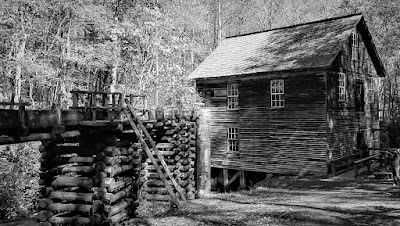
For 50 years, nearby farmers brought their corn and wheat to Mingus Mill, built in 1886. The miller usually charged a toll of one-eighth of the grain the customer brought for milling. The gristmill's stone was turned by a water-powered, cast-iron turbine. From water pressure built up in the penstock at the flume's end, the turbine generated 11 horsepower, enough to run all the mill's machinery. On the second floor, the smut machine blew wheat grain free of debris, while the bolting chest separated ground wheat into grades by sifting it through fine to coarse bolts of cloth.

Mingus was the largest gristmill in the Smokies. Its 200-foot-long wooden flume brings water to the mill's turbine. As early as the 1820's, more progressive millers began using turbines to power their mills rather than waterwheels. The Mingus family sold the mill to the National Park Service in the 1930's.


Continuing the scenic drive west on US-74, we headed for Juney Whank Falls and our next geocache (GCMBAZ). This puzzle cache requires gathering information along the 4.4 mile Deep Creek - Indian Creek loop trail. However once we arrived at the trailhead we weren't up for a long hike. So we just took the short hike to the first of several waterfalls for some photos.


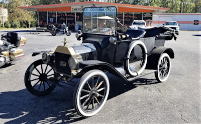
Here's one of those reasons why I like driving the backroads and byways through rural towns and communities across this great country. Passing by Cherokee County Cycles, I spotted this HUGE Harley-Davidson custom motorcycle along with a couple of other cool vehicles in the parking lot. I just had to pull in and get a few pics!


Crossing over into Tennessee, we check out the Great Copper Basin Earthcache (GCNP87) and a new caching county of Polk County. In 1843, a prospector, hoping to find gold south of the Coker Creek mine fields, instead located one of America's richest copper reserves. Over the next century, American and foreign companies chartered more than a dozen copper mines in the Ducktown Basin. The last mines closed in 1987. Many of the buildings still remain today.


We ended our day in Chattanooga at the National Cemetery for two virtual geocaches (GC5148, GC4E66). On Dec. 25, 1863, Maj. Gen. George H. Thomas, “The Rock of Chickamauga," issued General Orders No. 296 creating a national cemetery in commemoration of the Battles of Chattanooga, Nov. 23-27, 1863. Gen. Thomas selected the cemetery site during the assault of his troops that carried Missionary Ridge and brought the campaign to an end. The site Thomas selected was approximately 75 acres of a round hill rising with a uniform slope to a height of 100 feet; it faced Missionary Ridge on one side and Lookout Mountain on the other. Gen. Grant established his headquarters on the summit of the hill during the early phase of the four-day battle for Lookout Mountain.


By 1870, more than 12,800 interments were complete: 8,685 known and 4,189 unknown. The dead included men who fell at the battles of Chickamauga, Missionary Ridge and Lookout Mountain. There were also a number of reinterments from the surrounding area, including Athens, Charleston and locations along the line of Gen. Sherman’s march to Atlanta. A large number of men—1,798 remains—who died at the Battle of Chickamauga were relegated to unknowns during the reinterment process. In addition to Civil War veterans, there are 78 German prisoners of war buried here.

The Andrews Raiders Monument, erected by the state of Ohio in 1890, is among the most unique memorials in the cemetery. The granite base and die is topped with a bronze replica of “The General,” the Civil War-era wood-burning locomotive famous for its great chase of 1862.


Today, the Chattanooga National Cemetery encompasses just over 120 acres and nearly 60,000 permanent residents.

After 300 miles of driving, it was time to call it a night. Tomorrow is another day with new adventures and things to see. I hope you have enjoyed today's journey and will return for many more...

To follow along on our travels and keep up with my latest blogs, you may do so here of course. But also by using you favorite of these social media platforms: FacebookMeWeGabRedditParlorTwitterRVillageGETTR and Instagram. These all link directly to my profile. Again, please feel free to comment and / or share.
Saturday, January 15, 2022

2020-07-03: A Long Weekend Geocaching Counties and Hiking in Western North Carolina

Well we're working in North Carolina and have a 3-day holiday weekend. Do we chill at the RV Park or go exploring the Smoky Mountains and Geocache the remaining six counties to complete the state? It's a roadtrip of course! Grab the hiking boots, hop into the GeoJeep, and let's go sightseeing along the backroads of North Carolina!


Leaving the Lake Norman Motorcoach Resort behind for a few days, we headed west on NC Highway 18 until we got near Pleasant Grove. There we made a detour over to a bridge on Old North Carolina 18 for a First-to-Find attempt at a geocache published two days earlier (GC8VWYF). Another geocacher tried to find it the same day it was published without any success. I tried searching for nearly 30 minutes. But it wasn't for me to find on this day. I ended up having to log a DNF.

Driving north on US-321, I get off at the Mulberry exit for our next geocache (GC8MRYY). It was located near Silvervale Falls. These cascading falls are about 80 feet from top to bottom. Being this far from the Blue Ridge Parkway, there aren't as many tourists visiting these waterfalls. Only enough parking for 3 cars and we didn't have any problem. But worth the stop if you happen to be nearby.


One of the other reasons I like geocaching and traveling the backroads is that you never know what you might come across. Like this old rusty car, truck, and tractors lined up on the side of the road. I just had to stop and get a few photos.


Our next stop WAS to be Blowing Rock and then Grandfather Mountain. I've visited the Smokey Mountains and the Blue Ridge Parkway many times. However I have never made it to these two popular tourist destinations. Today it was going to be another of those times. It was July 4th weekend and the places were packed full and we did not want to contend with the crowds. So we continued on southbound down the Blue Ridge Parkway.

One of the first photo opp stops we took along the parkway was at the Wilson Creek Valley Overlook. A great view and you can see for miles!


Our next stop was a hike for a virtual geocache in the Linville Gorge Wilderness Area. The Linville Gorge Wilderness is part of the Pisgah National Forest. The gorge is formed by the Jonas Ridge on the east and Linville Mountain on the west and is bisected by the Linville River which drops 2,000 feet into the valleys below.

The virtual geocache (GC3A44) was a hike down the Spence Ridge Trailhead. This trail was supposed to take us down to the Linville River where we were to find the "House Rock," a flat top rock formation in the river that looks like a house. I wish I could show a picture of it, but we never made it. After about an hour of hiking, we were slowly getting closer but the destination appeared to be staying off to the right. Finally we decided to turn around and head back to the GeoJeep. As we were hiking back I noticed the correct trail we should have stayed on teeing off. Oh well, maybe next time.


Driving our way around to the other side of the Linville River we headed for our next virtual geocache called "Look At That" (GCG9YT). After 3.5 miles of gravel road, a little rough in a few spots, we made it to our destination at the Wiseman's View Scenic Overlook. Just a short walk from the parking area and you'll arrive at this viewing platform high above the gorge.


Driving back along the 3.5 mile gravel road, which is the Old NC 105 / CR 1238, I spotted this old road marker off the side in the weeds. After a few hours of research, Andrew Milton Kistler (1871-1931) was originally from Pennsylvania and became a prominent businessman in Morganton, Burke County, NC. First established in 1926 as the primary route between Nebo and Linville Falls, a 24 mile road that has since been rerouted and improved. The remaining Old NC 105 is now 17 miles of gravel road which can require 4x4 in some areas. That just added to the adventure in the GeoJeep.


We ended the day in Marion, NC. It was a pretty good day with the sightseeing, the hiking, the off-roading, and a little bit of history. I hope you have enjoyed todays adventure. See you back soon for another day of exploring the Smoky Mountains in Western North Carolina.

To follow along on our travels and keep up with my latest blogs, you may do so here of course. But also by using you favorite of these social media platforms: FacebookMeWeGabRedditParlorTwitterRVillageGETTR and Instagram. These all link directly to my profile. Again, please feel free to comment and / or share.

Saturday, January 1, 2022

2020-06-20: Taking a Trip Back to Mayberry and Andy Griffith's Hometown of Mount Airy, North Carolina

Welcome back friends, family, fellow traveler's, Geocachers, Jeepers, RV'ers, and ALL of you who've stopped by our AwayWeGo's Geocaching Adventures Blog. We're a couple of work travelers in construction and our job takes us all over the country. Currently, we're on a project in Central North Carolina near the town of Maiden.

Today was a great day to take a roadtrip back to Mayberry (GCJF95). Many say that "The Andy Griffith Show" was based on Mount Airy, NC, Andy's birthplace. So let's go for a drive and see what they've done to the town.

Mount Airy was settled in the 1750s as a stagecoach stop on the road between Winston-Salem, North Carolina and Galax, Virginia. It was named for a nearby plantation. Mount Airy was incorporated in 1885. The City's official seal was established in 1977, which depicts major industries that are home to Mount Airy including: furniture, textiles, and the granite quarry. In 1994, Mount Airy was named an All American City.


The Andy Griffith Show aired eight seasons on CBS from October 3, 1960, to April 1, 1968. The series originated partly from a prior episode of The Danny Thomas Show. The show stars Andy Griffith as Andy Taylor, the widowed sheriff of Mayberry, North Carolina, a fictional community loosely based on Mount Airy. Other major characters include Andy's cousin, the well-meaning and enthusiastic deputy, Barney Fife; Andy's aunt and housekeeper, Bee Taylor; and Andy's young son, Opie. Griffith said that the show evoked nostalgia, saying though it was shot in the '60s, it had a feeling of the '30s. It was, when we were doing it, of a time gone by."


Griffith was born on June 1, 1926, in Mount Airy, North Carolina, the only child of Carl Lee Griffith and his wife, Geneva. As a baby, Griffith lived with relatives until his parents could afford to buy a home. With neither a crib nor a bed, he slept in dresser drawers for several months. In 1929, when Griffith was three, his father began working as a helper or carpenter and purchased the home pictured below in Mount Airy's "blue-collar" south side. Griffith grew up listening to music. By the time he entered school, he was well aware that he was from what many considered the "wrong side of the tracks". He was a shy student, but once he found a way to make his peers laugh, he began to come out of his shell and come into his own.


The Mayberry Courthouse is a replica of the courthouse that appeared in “The Andy Griffith Show” during the 1960s. Situated adjacent to Wally’s Service Station, visitors can sit behind Andy’s desk, type on the vintage typewriter, and even sit in the recreated jail cells that appeared in the show.


Remember Sheriff Taylor’s police car? The one you saw in every episode? In Mount Airy, you can tour all of the sites in a Mayberry squad car. Each tour starts at Wally’s Service Station, then it will travel up and down the streets of Mount Airy. Wally’s Service Station is an original service station built in 1937 and operated as a Gulf Station and then later operated as a Standard Oil Station or Esso.


As a student at Mayberry Union High (Mount Airy High School), Griffith cultivated an interest in the arts, and he participated in the school's drama program. A growing love of music, particularly swing, would change his life. Griffith was raised Baptist and looked up to Ed Mickey, a minister at Grace Moravian Church, who led the brass band and taught him to sing and play the trombone. Mickey nurtured Griffith's talent throughout high school until graduation in 1944.


The Darlings (usually pronounced "Darlin's") lived in a mountain shack, like the one below behind Wally's Garage, somewhere in the mountains neighboring Mayberry. The good-natured, but trouble-making Appalachian clan, led by patriarch Briscoe Darling (played by Denver Pyle) usually came into town piled into the back of their old truck.


Though Methodists had been present in Surry County since the 18th century along with Baptists, Moravians, Quakers, and other religious groups, the original Methodist church in town was established only in 1831. The “Old Methodist” cemetery belonged to Mount Airy’s Methodist Episcopal Church, South, after part of the 1831 Lebanon congregation moved to a new location on South Main Street in 1858. The cemetery and church were built on land donated from Elisha Banner’s plantation, and the earliest burial dates back to 1857.


Local tradition says that the church’s bell, now housed in Trinity Episcopal’s belfry, tolled during funerals for every year of the deceased’s life. The cemetery acted as a town cemetery, not just for one for Methodists, and it was replaced by Oakdale Cemetery in 1892 when space began to run out. The church changed its name to Central United Methodist Church when it moved closer to the center of town in the 1890s, and the last burials at the Old Methodist Cemetery (GC4NZNT) were made around the turn of the century.


Leaving Mayberry, we drove down the highway on the way back but not before hiking Mount Pilot. Pilot Mountain was the inspiration for the fictional town of Mount Pilot in “The Andy Griffith Show.” Nearby the actual town is Pilot Mount State Park (GC88Z1Y) which is known for its Big Pinnacle peak seen for several miles. It was a nice short hike over to the observation deck where I got this great wide angle photo.


That was our return to Mayberry. It's one of those must visit towns if you're a fan of the of the TV show.

To follow along on our travels and keep up with my latest blogs, you may do so here of course. But also by using you favorite of these social media platforms: FacebookMeWeGabRedditParlorTwitterRVillageGETTR and Instagram. These all link directly to my profile. Again, please feel free to comment and / or share.

Saturday, October 23, 2021

2020-04-19: Geocaching Florida From Fort White to Cedar Key to Find a Closed Island, a Ghost Town, and an Old House

Hello everyone! So after our quick couple of weeks at the Georgia project, we're back in our home state of Florida to start a new project in Fort White! We arrived mid-week and check into the River Run Campground. After working the remainder of the week, we had the first weekend off so it was time to go exploring and geocaching along the rural backroads of Florida. So hop on in the GeoJeep and let's go see what we can find...


First on the list for Saturday was driving on up to Discount Tire in Lake City. After two years and 100,000 miles on the GeoJeep, it was time to finally upgrade to some new tires and wheels. Because we do drive it a LOT, I didn't want to go too big and loose the 16-18 MPG. But I did want something that looked a little more off-road than the originals. I like it! What do you think?


On Sunday, we decided to take a drive on over to the Gulf Coast at Cedar Key. What a great way to spend a spring day but on a beach in Florida, Right? NOT! We drove all the way down here only to find that the island is closed off to non-residents because of the virus. Well so much for that plan. We head back towards Fort White grabbing geocaches along the way starting with two quick roadside caches on Hwy 24 on the way to Cedar Key (GC1AHDY, GC6FJWA).

Approaching Chiefland, we grabbed a roadside geocache on CR345 (GC4YP47). Then in Chiefland, we passed by Barnhill Landscape and they had a landscape display which I just had to stop and get some pics of. This one especially was my favorite of an old school bus crossing a rickety bridge. I give you two versions; the black and white photo below and the color photo from a different angle at the top of the blog post.


The next stop was for a geocache at the ghost town and Levyville Cemetery (GC44F5N). The history of Levyville is short. The Levy County seat for only a few years in the mid-1800's. The town slowly disappeared after losing its position to Bronson in 1870, and was virtually non-existent by the early 1900's. The railroad could "make or break" a town, and bypassing Levyville definitely broke it. There was a brief Civil War skirmish fought in the area as well. The "new" courthouse, built in 1867, which became redundant when Bronson became the county seat, was sold to the newly-formed Masonic Lodge #51 in 1870, and eventually moved to Chiefland. All that remains of this historic town are two cemeteries. This one has nearly 60 interments with the oldest belonging to Levi Wright who died in 1858.


Then there was "This Old House" (GC3HAY9) located in Bell, Florida. I couldn't find anything out about this house or when it was built. It does kinda remind me of the Jed Clampett house before he moved to Beverly Hills.


And finally, an Earthcache at the Suwannee River (GC679MY). This is what natural Florida looks like. The water level was a little high at this time. This is just one of the many public boat ramps to access this 246 mile long river which flows from south Georgia to the Gulf of Mexico.


That's it for today. Not a very big roadtrip, but a nice drive nonetheless. Until next time, see you back here soon...

To follow along on our travels and keep up with my latest blogs, you may do so here of course. But also by using you favorite of these social media platforms: FacebookMeWeGabRedditParlorTwitter, and Instagram. These all link directly to my profile. Again, please feel free to comment and / or share.
Saturday, October 9, 2021

2020-04-05: Geocaching Counties Around Georgia and Finding a Covered Bridge, an Old Jeep, Cemeteries and More

Welcome back to the AwayWeGo Geocaching Adventures blog. Our job has us traveling all across the country. We prefer the rural backroad and byways when driving from jobsite to jobsite because they have the most interesting places. We find most of these historic and roadside attractions because of geocaching, but then there are often a lot of unexpected surprises too.

In today's edition, we've been in Georgia working for a week now and it's our first day off. So of course it's time for a mini-roadtrip around the backroads of Georgia to add some new counties to the geocaching map. So hop on in the GeoJeep and let's go see what we can find!


A short drive down the road on the way to our first geocache, I pass by this house with some old rusty farm equipment off to the side. But what caught my eye the most was the old rusty Jeep. Along with the trucks back within the trees, it's kinda sad that they're just abandoned and left to rust and rot away.


Now in Webster County, it was a quick roadside geocache stop for the county (GC1W1MN).

Driving north on Georgia Hwy 41, we arrived in Marion County. Right at the county line is what remains of the ghost town community of Church Hill (GC71HPY). As early as 1812, Methodist missionaries came into this area and found the Indians to be receptive to the Gospel, so missions were established to teach and minister to the Indians. Following these missionaries came large numbers of immigrants from the eastern United States and from North and South Carolina. The mission points were established along trading paths which developed into the "Old Salt Trail" and later St Mary's Road from Columbus to the coast.


Here near three crossroads, a large church community developed. Five churches soon sprung up in this community originally known as Searsville. After the Baptist, Methodist, Presbyterian, Bible Baptist, and Christian Church's were established the area was more commonly known as Church Hill. The Shiloh-Marion Missionary Baptist Church is the only remaining church of the five. What began as a Baptist Missions Point in 1812, became Shiloh Baptist Church in 1835 with 8 members. At its peak it grew to 150 members. Presently there are about 12. A time capsule was placed back in 1995 to be opened in 2045. (For a full recount of the history of Church Hill with photos and more, visit https://ursa.mercer.edu/handle/10898/12398)


Across the street is the Shiloh Baptist Church Cemetery. Many of the communities early pioneers and Civil War veterans are buried here. There are also some smaller cemeteries nearby and all that remain of the other churches. Among the cemeteries are segregated sections, one for slaves and another for Native Americans.


Also in Marion County and further north in the town of Buena Vista, we stopped for another geocache behind the historic old Gypsy Camp Grist Mill (GC71K1Q). There were a LOT of logs out behind the building and I spent a LOT of time looking at all the possible hiding places. But I wasn't able to find the cache and had to DNF it. But I did learn some history.

The Gypsy Camp Grist Mill was moved from its original location to its current site on the Murray Estate in 1930. At the time, the mill was a key agricultural asset to the community. It used electricity to power a network of chutes and belts woven through the three-story building to grind corn into meal. It operated for thirty years, closing in the early 1960's. Gypsy Camp Grist Mill got its name from a nearby campground and store where for a few weeks every winter ‘gypsies’ made their home, purchased supplies, and traded. The gypsies were believed to be of Serbian and Russian decent and migrated to the United States during the 1850's.


Crossing the line into Talbot County, I make a quick stop to find a geocache in an old pay phone (GC51AA7). Then at the top of the county there was another geocache at this historical marker (GC3XR5X). A large memorial which reads: "In Honor of Our Confederate Heroes, Sons of Confederate Veterans 1896, Echols Guards Camp #1711 S.C.V., 2005"


Next up in Meriwether County, in the town of Manchester, is this train car and my next geocache (GC70TEH). It's called Elliott Station as a memorial for Tyron Elliott, a prominent member of the community.


The next two geocaches were at the Red Oak Creek Covered Bridge (GC2885, GC6QDNP). Also located in Meriwether County, this bridge was built in the 1840's by freed slave and noted bridge builder Horace King (1807 - 1885). Constructed on the town lattice design, the bridge's web of planks crisscrossing at 45- to 60-degree angles are fastened at each intersection with a total of approximately 2,500 wooden pegs, or trunnels. Although King is credited with the construction of many covered bridges throughout West Georgia, this is his only surviving bridge of this design. At 391 feet, including the approaches, this structure is the oldest and longest wooden covered bridge in Georgia. And you can still drive across it!


If you look carefully down the side of the covered bridge you will notice a change in the wood forming a line about 2/3 of the way up the side. On July 7, 1994, the river flooded over and rose up to that height.


Now in Coweta County in the town of Senoia, there's another bridge. This town in Georgia is often used in filming the TV show "The Walking Dead." In The Walking Dead, this old bridge, which crosses over railroad tracks, is in the fictional town of "Woodbury" in the TV show. While I didn't find the geocache (GC86RNR) on the bridge, I still like finding old bridges.


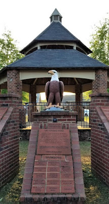
Here's the GeoJeep in downtown Senoia. You might recognize this street scene and a gazebo where a virtual geocache (GC89183) is located in other films such as "Driving Miss Daisy" and "Fried Green Tomatoes."


Crossing Line Creek into Fayette County, I stopped for a quick park & grab Challenge Cache (GC6JM2D). A Challenge Cache is usually a simple cache to find. However you have to meet certain achievements in order to log a find on it. This one requires you to have found 1000 geocaches before logging a "Found It." I passed that accomplishment a long time ago! And then there was the State Souvenir Challenge cache (GC7QN34) up the road. That one required you to find a least one cache in 10 different states. Yep, passed that one a long time ago too!

From there taking GA-34 over into Heard County and the town of Franklin, I make a quick find at the Veterans Memorial Park (GC69X5M).


Nearly 8 PM and heading south, I make one more stop as it's getting dark for a quick cache in Troup County (GC2D30C). We picked up nine new caching counties on this run today. Still a little more than 100 miles of driving to get back and I gotta work tomorrow, we drive straight there. Found a lot of history on our adventure today. I hope you have enjoyed the ride and come back soon. See you next time...

To follow along on our travels and keep up with my latest blogs, you may do so here of course. But also by using you favorite of these social media platforms: FacebookMeWeGabRedditParlorTwitter, and Instagram. These all link directly to my profile. Again, please feel free to comment and / or share.