Showing posts with label counties. Show all posts

Tuesday, May 6, 2025

2021-08-15: Exploring South East Montana in the Jeep While Geocaching

Today we started a little geocaching road trip around Montana to pick up some new caching counties. We drove the backroads in our GeoJeep finding geocaches which took us to some interesting locations. So travel back with us as we go sightseeing, finding a long abandoned car, some creative metal statues, and some wildlife.


On the way to our first geocache, we past by these custom yard art metal sculptures. I just had to pull over and get some photos.


The first geocache (GC4PETT) took us high up on a hill. We found the geocache pretty quickly. But the real treat was the spectacular view from up there.


The next geocache over in Stillwater County was called "Hard Times Cache" (GCVHFP). The cache was an ammo can hidden in this old antique abandoned car that had probably been parked there for over a half century. Ya gotta wonder what stories this car could tell.


Also in Stillwater County was our next and a high favorite points geocache (GC15GG0). It was located by the big bear outside the office of the Old West RV Park. It was a nice RV park and looked like a great place to setup camp. But we're traveling and exploring in the GeoJeep and left the motorhome back in Bridger.


Continuing westbound, we entered into Sweet Grass County for our next four geocaches. First up was at the Greycliff Prairie Dog Town State Park for two geocaches (GC1X4BY, GCX39H). There were probably a thousand or more of these prairie dogs running around and ducking in and out of holes. We spent about 30 minutes watching these critters before moving on.


A few miles further down the road is the town of Big Timber. Just off the exit is the Big Timber Information Center and the next geocache (GCKHRJ). On the patio of the information center is a metal sculpture of the "Cowboy Artist." Charles Marion Russell, 1864-1926, was an American artist of the American Old West. He created more than 2,000 paintings of cowboys, Native Americans, and landscapes set in the western United States and in Alberta, Canada, in addition to bronze sculptures.


The last one for the county was right on the edge, just off the exit, and had nearly 300 favorite points. The star was not the location but the geocache (GC3GZT2). Best to explain with a video:


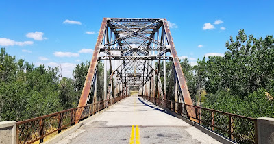
Taking a backroad north from that exit, we crossed over into Park County. It was just a mile up that road where we arrived at the Yellowstone River and our next geocache (GC2W0GC). Here is what remains of the old bridge and can see to the right in the photo a piece of the new bridge crossing over. But predating both of these is where Captain Lewis Clark, half of the Lewis & Clark Expedition, along with along with several other men, Sacajawea, her 18 month old son, and 49 horses passed through here way back in July of 1806 on their way back to reunite with Lewis. 


Two exits west on I-90 later, we stopped for another geocache (GC2WTFW) for more Old West history. John Bozeman is noted first for the 1863 establishing of the Bozeman Cutoff (or Bozeman Trail) as a shorter freight route through Wyoming to the Montana gold fields. He laid out the town of Bozeman in 1864. In April 1867 he was traveling eastward through this area with partner Tom Cover to Ft. Phil Kearny. In camp 2+ miles upriver from here they were reportedly attacked by five Blackfeet when Bozeman was killed. Inconsistencies in the story and evidence at the site lead some historians to suspect Cover of the death. Bozeman, 32 years old at the time, was buried there for two years, then moved to the Bozeman cemetery.

Another exit and we arrive at the Fort Parker Historical Site and our next geocache (GC1X3BR). This area along the Yellowstone River once served as south-central Montana's cultural crossroads between 1868 and 1875. This was a place where settlers and Indians traded goods and services. Built here in 1869, Fort Parker was the first Crow Agency and a resting point for white explorers as well as Indian leaders. Virtually every major expedition into the Yellowstone Park stopped here. The fort was burned down a year after it was built and replaced with a poorly constructed adobe fort. In 1875, the government moved the Crow Agency to near Absarokee, Montana.


Continuing on into Gallatin County, we stopped for a geocache (GC4CG9K) and historical marker. In 1864, John Bozeman and John M. Jacobs opened the Bozeman Trail. This new trail splits off the Oregon Trail near Douglas, Wyoming and heads north into Montana near Wyola. From there it goes west along I-90 through the town of Bozeman and into Virginia City.

Now we start to head back to the RV in Bridger when we noticed the Montana Grizzly Encounter across the highway. This might be our only chance to see some wildlife while we're up here. Well aside from the gift shop, there was an outdoor area of about an acre with a small pond in the middle. There was only one grizzly bear to see. Five minutes, a few photos, and we're back on the road.


Well that's it for this day. Time to head back to Bridger. We've got more of Montana and Wyoming to come.

To follow along on our travels and keep up with my latest blogs, you may do so here of course by clicking the "Follow" button to the right. And there's also my main website at AwayWeGo.US for the complete index of my traveling adventures going back to 2005. But also by using one or more of your favorite of these social media platforms: FacebookMeWeGabRedditTwitterGETTRInstagram, and TruthSocial. These all link directly to my profiles. Again, please feel free to comment and / or share.

Sunday, September 8, 2024

2021-08-11: Visiting Montana, Little Bighorn Battlefield, and Custer's Last Stand

Welcome back friends, RV'ers, Geocachers, Jeepers, and fellow travelers. When we last left you, we had just arrived to our next RV park in Bridger, Montana. The last time I was this far up in the northwest was way back in 2008 as a truck driver. While driving a big rig you don't get to see too much except out the windshield. This time we have the GeoJeep to get around and do some sightseeing. Today we start out at the historical Little Big Horn and Custer's Last Stand. So click and follow along as we tour these sacred grounds...


The Little Bighorn Battlefield National Monument Park (GC6F9E) covers an area of about 765 acres. It consists of the Battle of Little Bighorn that took place on June 25th & 26th, 1876 where Lt. Col. George Armstrong Custer and the 7th Calvary fell against the combined Cheyenne, Sioux and Arapaho force. It also includes the Custer National Cemetery and the battlefield site of the Reno-Benteen skirmish, about 3 miles southeast, with the Cheyenne-Arapaho warriors.


Following the fall of Custer and the 7th Calvary, the 11th Infantry led by Captain George K Sanderson buried Custer and his men on the battlefield where they fell. He also constructed the first monument on the site. From his official report dated April 7th, 1879 he wrote:

    "I accordingly built a mound out of cord wood filled in the center with all the horse bones I could find on the field. In the center of the mound I dug a grave and interred all the human bones that could be found, in all, parts of four or five different bodies. This grave was then built up with wood for four feet above ground. The mound is ten feet square and about eleven feet high; is built on the highest point immediately in rear of where Gen'l Custer's body was found."

In July of 1881, Lieutenant Charles F Roe and the 2nd Calvary built the granite memorial which still stands today on top of Last Stand Hill. About 220 soldiers remains were reinterred around the base of the new memorial, but left the markers in place where they had fallen.


In 1890, the stakes which marked where the soldiers had fallen were replaced with the marble markers you see today. Starting in 1999, the first of many red granite markers for the Cheyenne, Sioux and Arapaho Warriors were set in place where they fell.


To make it easier to spot for the hundreds of thousands of tourists who visit each year, Custer's marker was given a black background. Custer's remains had been reinterred to West Point long ago back in 1877, as well as many of the other officers remains were moved to Fort Leavenworth, Kansas or cemeteries across the country as requested by their families.


Custer National Cemetery was first designated as a U.S. National Cemetery on January 29, 1979 to protect the soldiers graves buried there. In December of 1886 it was re-designated as the National Cemetery of Custer's Battlefield Reservation to include soldiers graves of other wars. Eventually the name was shortened to Custer National Cemetery. Buried soldiers of the 7th Calvary, whos remains were discovered on the battlefield after the 1881 memorial was built, were reinterred here and listed as unknown.


The remains from 25 other cemeteries were transferred to here when frontier forts closed at the end of the Indian Wars. The fallen from many famous battles, Fetterman, Wagon Box, Hayfield, Big Hole and Bear Paw, now rest here.

Until reaching capacity in 1978, this cemetery accepted reservations for veterans and their spouses. There are soldiers here who fought in the Indian Wars, Spanish American War, World Wars I & II, Korea, and Vietnam.

There's a great book written by James Donovan that I highly recommend. "A Terrible Glory: Custer and the Little Bighorn: The Last Great Battle of the American West" is a great book put together from survivor accounts, official reports, and battlefield evidence. We listen to a lot of audio books while traveling down the road and this was one of our favorites. After listening to the Park Ranger give a summarized play-by-play of the battle, the welcome center recommended this book. We listened to it over the next couple of days as we drove around Montana.

After our visit to the battlefield site, we decided to go out geocaching and pickup some new Montana counties. The first one was also in Big Horn County in the town of Hardin. It was a travel bug hotel cache (GC4F5XD) located near the office to an RV park.

On the way to our next geocache, we crossed over into Yellowstone County. Along the side of Highway 47 was this old farmhouse that I just had to pull over and get a photo.


The geocache (GCKNZ4) was near a boat access ramp along the Big Horn River at I-94 and Highway 47. The geocache is called Manual Lisa. A little history lesson from the cache description:

    "Manual Lisa was a Cuban native. He lived 1772-1820. He was called Nebr, first white settler. He came up the Missouri in 1807 to start a fur trading venture. He built the 1st Fort Lisa on the Big Horn River. This fort was also called Manual Fort or Fort Manual. Unfortunately, he had to abandon the fort due to pressure from the British and the Indians. He was married to Mary Hampstead Keeney of St. Louis and they traveled between St. Louis and the Bighorn. She assisted the Yellowstone Expedition which had established its headquarters near the Lisa Trading Post. Manual Lisa saw himself as an Indian benefactor not an exploiter. He wrote to William Clark in 1817 (three years before he died) that he had distributed various seeds to help the Indians grow things. Some of these seeds were pumpkins, beans, turnips, and potatoes. He also loaned them traps and arranged for black smithing as needed.

    "There is a stone in this area (unfortunately they are on private land) where he carved his name M. Lisa-1807 and another stone with Colter 1810. They are somewhere around the mouth of the Bighorn. The Bighorn and the Yellowstone rivers flow together in this area. There are pictures of these stones at the cafe/casino in Custer, Mt. The pictures were taken in 1920 and you can clearly see the names. The Chamber of Commerce in Hardin, Mt. is trying to put more information together on historical sites in this area."

Well I didn't get to see the 200 year old names carved in the stone. But I did get a good view of the Big Horn River and an old bridge around the corner.


Going east on I-94, we cross over into Treasure County. Just off the Hysham exit is the Memorial Vale Cemetery and our next geocache (GC51TNW). There was a caretaker out there installing a new headstone. After watching for a few minutes, he didn't seem to care much about our activity. So I jumped out of the GeoJeep real quick, found the cache, signed to log, and went on our way.


And finally, the last geocache was further down I-94 into Rosebud County. Just a quick earthcache at a highway rest area (GC1GCXE). Now on back to the motorhome to end the day. Thanks for riding along. 

To follow along on our travels and keep up with my latest blogs, you may do so here of course by clicking the "Follow" button to the right. And there's also my main website at AwayWeGo.US for the complete index of my traveling adventures going back to 2005. But also by using one or more of your favorite of these social media platforms: FacebookMeWeGabRedditTwitterGETTRInstagram, and TruthSocial. These all link directly to my profiles. Again, please feel free to comment and / or share.

Sunday, August 18, 2024

2021-08-10: Geocaching Through Wyoming and Into Montana Reaching Our Destination

Well we woke up this morning at the Wyoming Welcome Center just south of Cheyenne. The goal for today is to reach our destination in Bridger, Montana. Hopefully along the way we'll have opportunities for some sightseeing and picking up new counties for our geocaching map. So click along and join us. What did we discover today?


So we set out from the Welcome Center and headed north up I-25. Just over an hour later, I exit into the Dyer Junction Rest Area located in Platte County. After finding the geocache (GC7FP6B) for the county, we read the many information boards and took some photos. To the east we got a distant view of Laramie Peak.


The next four paragraphs are from one of the Historical Information Boards:

    As you journey through Wyoming, you are one of the countless travelers who has looked out to the west and seen the granite rising of Laramie Peak. Near Scottsbluff, Nebraska, approximately 80 miles east of Dyer Junction, emigrants witnessed their first view of the western mountains with the hazy silhouette of Laramie Peak. Although the sight may have been awe-inspiring for the emigrants traveling on the Oregon and Mormon Trails, it also indicated the start of their journey into the mountains ~ a much more treacherous expedition than that across the plains.

    In their diaries, emigrants and other travelers usually noted seeing Laramie Peak. In Chapter IX of his 1891 Roughing It, Mark Twain wrote, "We passed Fort Laramie in the night, and on the seventh morning out we found ourselves in the Black Hills, with Laramie Peak at our elbow (apparently) looming vast and solitary ~ a deep, dark, rich indigo blue in hue, so portentously did the old colossus frown under his beetling brows of storm-cloud. He was thirty or forty miles away, in reality, but he only seemed removed a little beyond the low ridge to our right."

    Laramie Peak, which stands at 10,272 feet above sea level, is the highest Wyoming point in the Laramie Range. Part of the central Rocky Mountains, the Laramie Range, originally called the Black Hills, reaches for 125 miles from the Colorado-Wyoming border to the North Platte River near Casper.

    Visible from over 100 miles away, Laramie Peak is named for the early French trapper, Jacques La Ramie. While on a beaver trapping expedition, La Ramie vanished from what is now the Laramie River. Upon learning of his disappearance, other trappers in the region named the river after him. Soon the nearby mountains, plains, and many other areas also took the name.

Driving further up into Converse County, we stopped at the Orin Junction Rest Area for another geocache (GC33N3D).

Just east of Casper, Wyoming was a T/A Truck Stop. There we fueled up and found another geocache for Natrona County (GC5CHCQ).

Still headed north on I-25, we stop at the Kaycee Rest Area for a geocache in Johnson County (GC8BC7Z).

Now driving on I-90, we make one last stop at the Wyoming Information Rest Stop in Sheridan County for our final geocache of the day (GC97JGC).

We finally crossed over into Montana via I-90 up through Billings. We don't have much further to go, therefore I skip geocaching counties because it would be much easier in the GeoJeep vs the big motorhome. So it's I-90 to Laurel, then turn south on US-212. At Rockvale, turning south on US-310 a few more miles and arrive in the town of Bridger.

But just as we pull into town I noticed the RV's temperature gauge starting to climb. Luckily we're just 3 blocks from the City Park RV Park. I quickly pick a spot and park. Then I head to the bedroom and lift up the bed to get a good look at the top of the engine. Sure enough, another freeze plug on the side of the head has sprung a leak! That makes the third one!


OK, so there's only two auto repair shops in town. One is practically right across the street. I go there first. Nope, they only work on cars plus they're booked solid. So then I drive around the corner to Carbon Equipment Repair. Yes, they do work on diesel, big rigs, and farm equipment. But they too are booked out for a month. And we're only here for two weeks. I say we can't go anywhere and we're pretty much at their mercy. Nothing to do now but to wait and see.

In the meantime, I'm still waiting for the other surveyor to show up. So that means a free week. Sounds to me like a geocaching road trip around Montana might be in the making. I hope to see you back again soon.

To follow along on our travels and keep up with my latest blogs, you may do so here of course by clicking the "Follow" button to the right. And there's also my main website at AwayWeGo.US for the complete index of my traveling adventures going back to 2005. But also by using one or more of your favorite of these social media platforms: FacebookMeWeGabRedditTwitterGETTRInstagram, and TruthSocial. These all link directly to my profiles. Again, please feel free to comment and / or share.

Saturday, August 3, 2024

2021-08-09: Road Trip from Colorado to Wyoming in the Motorhome While Geocaching

A few days into this road trip from Texas to Montana and it has already been an eventful road trip to say the least. Within a few hours of starting out in Texas, I had an air suspension issue that I luckily was able to fix myself in a parking lot. Then the next day made it up into Colorado and was able to do some sightseeing and geocaching before another breakdown. This time a blown freeze plug leaking engine coolant everywhere. That brings us to waking up this morning in a little town called Kit Carson, Colorado. Is the one mechanic in town able to get us back on the road today or are we stranded until who knows when? Let's hop into the Jeep and see if he's even open...


Following the directions from the RV park owner, the shop is behind his house on the edge of town. I get there at 8:00 in the morning and he's already underneath a pickup truck. He says he's got a full work load and working alone doesn't really do mobile repairs. But he understands my predicament and says to give him an hour or so to get the truck's fuel tank re-installed so that it doesn't fall off the jack. Then he'll drive over to the RV park and check out the leak. GREAT!

Having a little bit of free time before he gets to the motorhome, I decided to grab the two geocaches in town. The first was over at the Kit Carson Cemetery (GC1EF8H). Then back to the center of town at the Kit Carson Railroad Depot (GCV3R5). From the historical marker: "Built in 1904, this depot has survived intact and is not significantly changed. It is one of a handful of surviving railroad depots of the period in Colorado and may well be in the best condition of those remaining. In addition to housing the station agent and his family, this rectangular depot accommodated the daily activities of train passengers, freight, and the telegraph, and is a distinguishing feature of this depot."


Shortly after arriving back at the RV, the mechanic shows up too. The coolant leak from the bad expansion plug is up top on the exhaust side of the head on the Cummins diesel engine. To work on the top of the engine you have to go inside the coach. Opening the "hood" of this motorhome is lifting up the bed.

So I show him where the leak was coming from and he checks it out. He pulls out the bad plug, cleans up the hole, and installs a temporary rubber adjustable expansion plug. Getting the correct size steel or brass would have to be ordered and may take a couple of days. This rubber one will work for a while and until. Hopefully I will eventually be able to find a shop that has the time to replace them all. Anyway, he got us fixed up and able to get back on the road. AND when I tried to pay him, he refused to accept my money and wished us well on our travels.

Now back on the road heading north on US-287, we eventually merge onto I-70 westbound. Once in Elbert County, I had found a geocache (GCQTWZ) by an off/on ramp that had a big enough shoulder to park the RV for a few minutes. See the first photo at the top of this blog. I made the quick find and then also noticed the old farm house and barn at the top of the hill. That made for a nice photo too.


A few miles up I-70 in Arapahoe County, I found another exit ramp with a geocache (GC8CD7) that had good parking. Turning onto I-25 northbound, another exit ramp geocache for Larimer County (GCY322) and then a rest area earthcache for Weld County (GC1ME6T). 

Finally crossing over into Wyoming, we pulled into the Welcome Center just south of Cheyenne where we decided to park for the night. The Wyoming Welcome Center is practically a museum / historical center. We must have taken about 50 photos. These are just a sample. From a petrified tree,


the "Hole in the Wall Gang" with Butch Cassidy and the Sundance Kid,


giant prehistoric skeletal bones that were once large beasts,


and Wyoming cowboys, rodeos and ranch life.


Also located at the Wyoming Welcome Center were two geocaches. One was a multi-cache (GC979A5) and the other an earthcache (GC93HTZ). These gave us credit for Laramie County.

After the tour of the Welcome Center, we drove about a mile to the next exit to grab a bite to eat. Also at the same exit was a virtual geocache (GC946E) that I couldn't pass up. My job is a surveyor and the cache was about a surveyor. 32-year old John Phippin was a dedicated employee of the National Geodetic Survey, Coast and Geodetic Survey.

A resident of Cheyenne, Wyoming, he was working in Blythe, California on an oceanic geodetic survey project in 1992. In April of that year, two men (I'm not gonna mention their names) quit their jobs as carnival workers and began on a crime and killing spree. They broke into Phippin's motel room where they beat him and then stabbed him in the heart. The two then proceeded to load up his possessions and stole his vehicle, which they drove to Las Vegas and murdered another man.


That's it for today. Tomorrow we arrive in Montana, hopefully trouble free! Stay tuned...

To follow along on our travels and keep up with my latest blogs, you may do so here of course by clicking the "Follow" button to the right. And there's also my main website at AwayWeGo.US for the complete index of my traveling adventures going back to 2005. But also by using one or more of your favorite of these social media platforms: FacebookMeWeGabRedditTwitterGETTRInstagram, and TruthSocial. These all link directly to my profiles. Again, please feel free to comment and / or share.

Saturday, January 20, 2024

2021-06-25: Searching for Lake Erie Lighthouses in New York, Pennsylvania, and Ohio

Welcome back to our AwayWeGo's Adventure blog. While the motorhome was getting some work done in Indiana, my wife, her granddaughter and I took a road trip to Connecticut and back in the Jeep. For todays leg of our travel journey we added lighthouses to our "to-do" list as well as geocaching counties. So climb aboard the GeoJeep and let's go for a drive... 


Our first stop was along the shores of Lake Erie in Chautauqua County and the town of Dunkirk, New York. The St Hyacinth Cemetery (GC4013R) has over 4,000 internments dating back to 1880. Land was purchased for the St Hyacinth Parish in 1875 and the newly completed church dedicated in 1876. This land wasn't purchased until 1902 to become the church cemetery. The cemetery chapel was blessed in 1942.


On the north side of Dunkirk jutting out into Lake Erie is Point Gratiot. The Dunkirk Lighthouse (GC4KMHE) and Victorian keepers residence was constructed during 1875-76 to replaced an eroding first light from 1827. Bricks from the original keepers house was used for the foundation in building the new house. When the cylindrical light tower was moved next to the house, a square walled tower was constructed around it to better conform to the aesthetics of the house.


Driving down NY-5 along the lakefront, we arrived in the town of Barcelona for our next set of geocaches and another lighthouse. We first stopped by the Barcelona Harbor Pier. Took a nice look around, took some photos of the water, and grabbed a geocache here too (GC1RMBW).


Off the edge of the pier near the road stands the Barcelona Lighthouse and Keepers Residence (GC1RMBW, GC60BK0). The 40-foot tall Barcelona Lighthouse was constructed in 1829. It was the first natural gas lighthouse in the country and was part of the Federal Lighthouse System up until 1859. From then it had been under several private ownerships over the years until the early 2000's when it became a state historical site.


Moving down into Erie County, Pennsylvania, we visited our next lighthouse and geocache. Located on the shores of Presque Isle Bay on Lake Erie is the "Land Lighthouse." The 49-foot tall sandstone tower was constructed in 1866-67. There is an earthcache here due to the fossils that can be found in the sandstone (GC93AYG). This was the third lighthouse to be constructed at this location due to the previous two having structural instabilities. The light was in use until 1899.


A few blocks away is Dobbins Landing named after Captain Daniel Dobbins, an Erie Pioneer and Mariner who sailed the Great Lakes as a merchant ship master and naval officer. As we walked towards the Bicentennial Tower we got to watch a little pirate show taking place off the pier. The Scallywags Pirate Adventure Show is a tourist sightseeing ship on Lake Erie which had a pirate navigating a small dingy trying to cause trouble. This made for an entertaining few moments for those on board.


Located at the end of Dobbins Landing stands the Bicentennial Tower Observation Deck (GC890ME). It was built in 1996 to commemorate the 200th anniversary of the founding of the city of Erie. The top observation deck stands 138 feet above Presque Isle Bay and provides spectacular 360 degree views up to 27 miles on a clear day.


Also nearby is the Erie Cemetery. We stopped by there before leaving town to attempt a Geocaching Adventure Lab (AL). Of the 40,000+ internments here I want to highlight this one. The Brown Mausoleum is more commonly known as "The Vampire Crypt." 

Local folklore says that a Romanian businessman was living inside the crypt. After his death of consumption, weird things began happening around Erie. The cemetery groundskeeper discovered that the man was living inside this crypt. The vault was then burned, the door chained, and the named chiseled off.


Moving over into Ohio, we continued our geocaching adventure along the Great Lakes. The first geocache was a quick parking lot park and grab cache (GC3NNRY) located in Ashtabula County.

The next two were in Lake County. The geocaches are located in the North Madison Cemetery (GC8JZDC, GC4CT2Z). According to the Find-A-Grave website, there are more than 2400+ internments dating back to 1811. In the midst of all the graves is the old maintenance shed. It looks kinda spooky itself.


It was getting late in the day so I found two more quick geocaches to pick up two more counties. The first was in the Mount Sinai Cemetery in Cuyahoga County (GCTNKW). There were over 2000 internments but I just found the geocache and moved on to the next. The final one was a light post cache in Geauga County (GC5FZGR).

That's it for today. Tomorrow we finish up Ohio and back into Indiana. Until then...

To follow along on our travels and keep up with my latest blogs, you may do so here of course by clicking the "Follow" button to the right. And there's also my main website at AwayWeGo.US for the complete index of my traveling adventures going back to 2005. But also by using one or more of your favorite of these social media platforms: FacebookMeWeGabRedditTwitterGETTRInstagram, and TruthSocial. These all link directly to my profiles. Again, please feel free to comment and / or share.

Friday, December 29, 2023

2021-06-24: More Sightseeing and Geocaching Cemeteries, Old Bridges, and Yard Art in Pennsylvania

In today's edition of the AwayWeGo's Adventures, with the RV still getting worked on, we spent another day in Pennsylvania sightseeing and geocaching. While out exploring today we found a couple of old bridges, a couple of cemeteries, and some custom auto art made of old cars and parts. Like the "Buzz Box" says: Look Inside by clicking on the link and seeing some of the unusual and creative pieces of yard art.


So yesterday was a lazy day off the road. We spent an extra day at the hotel to catch up on a weeks worth of laundry and just relax in front of the TV.

This morning after breakfast we drove west across Pennsylvania on I-80. North of Pittsburg, I exited the Interstate and drove north on US-19. On a previous road trip a few years ago we picked up US-19 on the south side of Pittsburg and drove it all the way down to Florida.

Driving north up the road, we caught a pair of racoons crossing the road. I had barely enough time to stop, grab the phone, and take a photo.


Our first geocaching stop was a little further up the road but still in Mercer County. In the town of Clarks Mills was the Perry Chapel Cemetery (GC51V01). The cemetery has just over 700 internments dating as far back as 1851.


About a mile up the road another geocache (GC51V05) brought me to this old railroad bridge across the Old Shenango River. I tried to find some historical information on this bridge but wasn't having any luck.


Taking another backroad about mile to the north of town and another geocache (GC51V0P) brings me to yet another old bridge. Only this time I did find some information on this bridge. The 82 foot long single span Pratt through truss bridge was built in 1885 by the Penn Bridge Company of Beaver Falls, PA. It is supposed to be demolished but hopefully it will never come to that. I like finding these old bridges.


Moving on up into Crawford County, I stopped for a geocache in the Johnston Cemetery (GC8Y2J3) near Keborts Corners. It's a small country cemetery with less than 100 internments dating back to the 1850's.


The final geocache of the day was a virtual cache and one that was on my bucket list for nearly ten years. But I'm just now getting around to this area of Erie County. Schaefer's Auto Art (GCJ8M8) was created by Dick Schaefer in 1988. Using his imagination while working in a junk yard, he began welding pieces and parts together to give them life.


Well that's it for today. Along with geocaching, tomorrow we add sightseeing stops at the Great Lakes lighthouses to our traveling journey.

To follow along on our travels and keep up with my latest blogs, you may do so here of course by clicking the "Follow" button to the right. And there's also my main website at AwayWeGo.US for the complete index of my traveling adventures going back to 2005. But also by using one or more of your favorite of these social media platforms: FacebookMeWeGabRedditTwitterGETTRInstagram, and TruthSocial. These all link directly to my profiles. Again, please feel free to comment and / or share.