Showing posts with label yard art. Show all posts

Friday, December 29, 2023

2021-06-24: More Sightseeing and Geocaching Cemeteries, Old Bridges, and Yard Art in Pennsylvania

In today's edition of the AwayWeGo's Adventures, with the RV still getting worked on, we spent another day in Pennsylvania sightseeing and geocaching. While out exploring today we found a couple of old bridges, a couple of cemeteries, and some custom auto art made of old cars and parts. Like the "Buzz Box" says: Look Inside by clicking on the link and seeing some of the unusual and creative pieces of yard art.


So yesterday was a lazy day off the road. We spent an extra day at the hotel to catch up on a weeks worth of laundry and just relax in front of the TV.

This morning after breakfast we drove west across Pennsylvania on I-80. North of Pittsburg, I exited the Interstate and drove north on US-19. On a previous road trip a few years ago we picked up US-19 on the south side of Pittsburg and drove it all the way down to Florida.

Driving north up the road, we caught a pair of racoons crossing the road. I had barely enough time to stop, grab the phone, and take a photo.


Our first geocaching stop was a little further up the road but still in Mercer County. In the town of Clarks Mills was the Perry Chapel Cemetery (GC51V01). The cemetery has just over 700 internments dating as far back as 1851.


About a mile up the road another geocache (GC51V05) brought me to this old railroad bridge across the Old Shenango River. I tried to find some historical information on this bridge but wasn't having any luck.


Taking another backroad about mile to the north of town and another geocache (GC51V0P) brings me to yet another old bridge. Only this time I did find some information on this bridge. The 82 foot long single span Pratt through truss bridge was built in 1885 by the Penn Bridge Company of Beaver Falls, PA. It is supposed to be demolished but hopefully it will never come to that. I like finding these old bridges.


Moving on up into Crawford County, I stopped for a geocache in the Johnston Cemetery (GC8Y2J3) near Keborts Corners. It's a small country cemetery with less than 100 internments dating back to the 1850's.


The final geocache of the day was a virtual cache and one that was on my bucket list for nearly ten years. But I'm just now getting around to this area of Erie County. Schaefer's Auto Art (GCJ8M8) was created by Dick Schaefer in 1988. Using his imagination while working in a junk yard, he began welding pieces and parts together to give them life.


Well that's it for today. Along with geocaching, tomorrow we add sightseeing stops at the Great Lakes lighthouses to our traveling journey.

To follow along on our travels and keep up with my latest blogs, you may do so here of course by clicking the "Follow" button to the right. And there's also my main website at AwayWeGo.US for the complete index of my traveling adventures going back to 2005. But also by using one or more of your favorite of these social media platforms: FacebookMeWeGabRedditTwitterGETTRInstagram, and TruthSocial. These all link directly to my profiles. Again, please feel free to comment and / or share.

Saturday, May 28, 2022

2020-11-14: Visiting the Kreische Brewery Monument Hill and the German Pioneers of Texas History

Todays little road trip took us up to the Kreische Brewery Monument Hill state historical sites in La Grange, Texas. Not only the site of a German immigrant's home and business, but the final resting place of 53 Texans who were killed in the continued skirmishes with Mexico after the Texas Independence. So let's go for a ride and take a walk through history. 


Kinda hard to drive straight there without stopping for a few other geocaches along the way. Our first stop was for an old geocache that has been around since February 2001 (GC29B). The geocache container was a second mailbox a half mile up along a geocachers driveway painted in the colors of the Texas state flag.

The next three geocaches were quick cemetery caches. The Holy Cross Catholic Cemetery (GC4GW6K) has over 1400 interments dating back to 1899. The Lissie Community Cemetery (GC4773G) is a small but well kept community cemetery with less than 150 interments dating back to the early 1890's. And the Lakeside Cemetery (GC47W3A) in Eagle Lake which has over 2600 interments which begin all the way back to the 1860's.

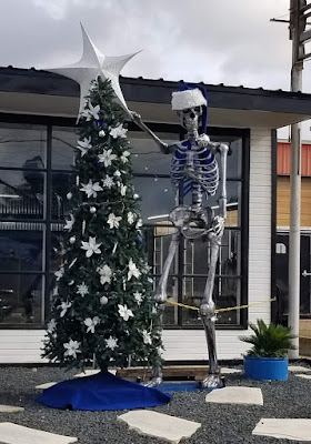
And then there's those unexpected crazy roadside things that make you do a u-turn and snap a quick photo! So here's this giant metal skeleton, probably left over from Halloween, now decorating a Christmas tree. The business is Fusion by Chris Vaughn. I checked out their website and he's a fabricator / designer of some really cool and unique home décor pieces.


Arriving at the Kreische Brewery Monument Hill state historical sites in La Grange, Texas, we stop first at the Monument Hill Tomb as seen at the top of this page. Even after the Republic of Texas won its independence from Mexico, Texans continued to battle in skirmishes with Mexico in continuing border disputes.

Meeting at great oak tree in downtown La Grange, Captain Nicholas Dawson gathered a company of 54 volunteers to help as Texas fought Mexico in and around San Antonio. On September 18, 1842, Dawson and his men made their way to join other Texas forces at the battle of Salado Creek near San Antonio. Along the way they were intercepted by Mexican troops and fighting ensued. Later known as the Dawson massacre, the conflict leaving 36 Texans dead -- including Dawson. Their remains are entombed in a granite crypt on a bluff overlooking the town. (GC3XF1C)


To prevent other attacks, President Sam Houston ordered General Somervell to march about 750 men towards the border. Upon reaching the Rio Grande, the general stopped the men from going forward due to a shortage of supplies. However Colonel Fisher and a group of 300 men continued on down towards the Mexican city of Mier to look for supplies. Fighting started but Fisher's men were outnumbered and eventually surrendered. The remaining men were then marched to prisons in southern Mexico.

During the forced march, the captured Texans managed to escape into the mountains at Hacienda Salado. There, many died without food, water, and shelter. While five managed to returned to the Republic, the remaining 176 men were recaptured. It was decided that every 10th man would be executed. To determine this, each prisoner would draw a bean. If they drew a white bean they live. If they drew a black bean they die. After writing letters home, the condemned men were lined up, blindfolded, and executed as depicted in the mural below. Known as the Black Bean Episode, the event cost 17 men their lives.


To ensure that these men were properly honored and interred, the La Grange community selected this hill for their final resting place in 1848 in a sandstone vault. The Kreische family did its best to care for the grave during their ownership of the property, but it suffered from a lack of formal oversight. In 1905, the state authorized acquisition of .36 acres here and the Daughters of the Republic of Texas raised funds for a new cover for the tomb in 1933. During the 1936 Centennial celebration, the 48-foot shellstone shaft with a stylized art-deco influenced mural was erected to mark the mass grave more prominently.

As for the Kreische family, German immigrant Heinrich Kreische (1821-1882) purchased nearly 175 acres of property in Fayette County in 1849. A stonemason by trade, he built a house, a barn, and smokehouse here on the high south bluff above the Colorado River.


In the 1860's, Kreische began brewing bluff beer near his homesite. Situated on the spring-fed creek, the brewery (GC1D2BQ) included an elaborate tunnel system to provide temperature control for the brewing process. Bluff Beer was sold throughout central Texas and was produced until 1884, two years after Kreische died in a work related accident. The Kreische complex stands as a reminder of German heritage and culture in this region of the state.


Our last stop of the day was a virtual geocache of European settlement history in Texas (GCGG9Q). The Wendish migration to Texas was impelled, in part, by the Prussian insistence that the Wends (or Sorbs, as they called themselves) speak and use the German language, even to the extent of Germanizing their names. The oppression of the Wendish minority extended to working conditions, with Wends being denied the right to do the skilled labor for which they were trained. If they were hired at all, they received less pay than their German counterparts. Prussian agrarian reform laws of 1832 dispossessed the Wends of their real property so they were, in effect, vassals to their Prussian lords.

But most intolerable was the requirement that the Lutheran Wends join the Evangelical Reform churches in one state-regulated Protestant body. The Wends believed this action would dilute their pure Lutheran faith and, rather than accept this decree, they made plans to immigrate to the New World.


In December of 1854, an English sailing vessel, the Ben Nevis, docked in Galveston harbor loaded with some 500 immigrants from Lusatia, an area in eastern Germany comprising parts of Saxony and Prussia. These Slavic pioneers who were to settle in Lee County made the journey from their homeland, not in search of prosperity, but rather in search of religious liberty and the right to speak their Wendish tongue.

On the 150th anniversary of Serbin, Texas, this monument was erected by the church and cemetery. The historical marker states: "Dedicated to the loving memory of those lost during the 1854 Wendish migration from Germany to Serbin. From September 10, 1854, until the dedication of the church cemetery on March 17, 1855, eighty-three men, women, and children perished in route to this place. Most were buried at sea."


Well that was it for this little road trip through Texas history. Better than sitting in a classroom reading from a book, getting out and visiting the small rural towns along America's backroads is very interesting to me and hopefully to you too. Thank you for riding along.

To follow along on our travels and keep up with my latest blogs, you may do so here of course. But also by using your favorite of these social media platforms: FacebookMeWeGabRedditParlorTwitterRVillageGETTR and Instagram. These all link directly to my profile. Again, please feel free to comment and / or share.

Saturday, September 25, 2021

2020-03-29: Roadtrip Day 3: Driving Through Mississippi and Alabama on the way to Georgia

Welcome back to day #3 of our east coast roadtrip from Texas to Georgia. For today we travelled through Mississippi and Alabama. We gotta long day ahead with a lot of stops, history, cemeteries, counties, and geocaches. So let's get rolling... 


After checking out of the hotel and grabbing breakfast, we found a quick geocache (GC30XDE) right next door to start the day with a Leflore County find. The next three geocaches were quick roadside caches for Carroll County (GC4GX44, GCQ0DW). The last one (GC11P5Y) was down by this creek where supposedly a family of bobcats were living. I even brought my good camera with the zoom lens just in case, but didn't see anything.


Still traveling eastbound on US-82, we stopped at the Old Middleton Cemetery (GC5J1PN) for a Montgomery County geocache find. The Middleton Cemetery was established in 1833 and has 126 interments with the last being in 1910. Then the cemetery was abandoned and went unmaintained for nearly a century. Finally there was an interest in the cemetery once again and most of the headstones were found broken and scattered. In 1992, the Winona Lion's Club cleaned up the 2 1/2 acres, reassembled the broken pieces, and arranged them together as a memorial.


More quick roadside geocaches to pick up some new counties in Mississippi: Webster County (GC7BW83), Choctaw County (GC7BW7J, GC7BW7B), Oktibbeha County (GC3WMG1), Clay County (GC48PN6, GC2DQQ2, GC3D99T), and Lowndes County (GC3CG7V, GC7ER16).

Continuing east on US-82 and crossing over into Alabama, our next stop was the Funderburk Family Cemetery (GC1X277). Located along US-82 on the west side of a tiny community of Coal Fire in Pickens County. Originally called Fundee, it was the combination of two settling families; the Funderburks and the DeLoaches. The name was eventually changed to Coal Fire or sometimes called Cold Fire after a local creek. A post office was established in 1871 but closed in 1927. This small family cemetery was downhill closer to where US-82 is today. When the widening of the highway to 4-lanes began, the state moved the thirteen graves further up the hill into the woods as you can see from the photo below. The graves date from 1850 to 1898.


Guardian of the Cache


One more quick geocache on the other side of the Coal Fire Community (GCVMR1) and we continued down the road.

The next three geocaches were in the Corinth Church Cemetery in Tuscaloosa County (GC333MN, GC4AR5A, GC4AR4T). I found two of them but had to DNF on one. This cemetery has over 600 interments dating back to 1860. The one that caught my eye though was this more recent black headstone with the mural on it.


Our next stop was near downtown Tuscaloosa, Alabama at the site of the State Capital Ruins for a virtual cache (GC7B7T6). In 1825, the Alabama State Senate agreed to move the capitol from Cahaba to the thriving town of Tuscaloosa. The building was completed in 1829 and had this beautiful copper dome that could be seen by all the passing vessels down the Warrior River below. The building was fashioned in the Greek Revival, and the Federal styles of Washington D.C. and Thomas Jefferson. The building was used as the capitol until 1846.

It was at this time that the state capitol was moved to Montgomery, down where more commerce was being conducted along the Alabama River with the majority of the states population. Tuscaloosa lost over half its population after the capitol was moved. The building was then given to The University of Alabama who seldom used it so they leased it to the Baptist Convention who established the Alabama Central Female College. In 1923 it burned down and was suspect to faulty wiring as the cause.


On the parameter of the square now known as Capital Park, sites a few historical buildings. This first one is the Old Tavern. Built in 1827 three blocks east on Broad Street, it was also a stage stop and inn frequently used by political leaders while Tuscaloosa was still the state capital. It was moved here to Capital Park in 1966.


When Alabama became a state in 1819, Tuscaloosa also was incorporated as a town. The following year in 1820, the McGuire-Strickland House was built. The house stands to this day as the oldest wooden framed home in Tuscaloosa. Originally located at the corner of Greensboro Avenue and 15th Street, this home was built for the county’s first probate judge, Moses McGuire. The home later served as the manse or preacher’s home for the First Presbyterian Church from 1844 to 1866. The house was bought by the Strickland family in 1866 and remained in the family for over a century until 1969 when it was given to the newly formed Tuscaloosa County Preservation Society. Around 1970 the home was moved from its original location to Capitol Park where it is currently used as part of the Capitol School.


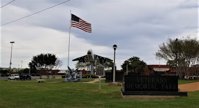
On the southeast side of Tuscaloosa is the Veterans Memorial Park and our next geocache (GC8BFBG). Some of the displays here include the Vought A-7E Corsair II, a 5 inch / 25 caliber "Dual Purpose" secondary artillery gun from the U.S.S. Tuscaloosa, a M60A3 TTS Medium Tank, and a Bell UH-1 Iroquis (Huey) Helicopter. This memorial was built on the site of the Northington General Hospital, a U.S. Army hospital operating here during World War II.


But of course my favorite was the Willys Jeep decked out in Air Force colors. Here's my GeoJeep TB with Uncle Willy.


Leaving Tuscaloosa and getting back down US-82, our next stop was a quick parking lot find at a Walmart in Bibb County (GC1K0NY).

And finally, our last geocache of the day was an old virtual cache called Just Plain Spooky (GCB13A) located in Autauga County. All the locals who live in Prattville are aware of this display, but visitors do not know about. Mr. Rice started this display in 1987 and added more to his collection year round, until he passed away in 2003. He wanted to 'spread the word'. His collection has been documented in a book that they have at local bookstores around Prattville and Montgomery. The photo I took is just a small section of what is probably four times the length of the display.


Well that's another 300 miles behind us, another 23 caches and almost 12 hours later. Time to stretch out and relax a bit. And tomorrow we'll start all over again! See ya back here real soon...

To follow along on our travels and keep up with my latest blogs, you may do so here of course. But also by using you favorite of these social media platforms: FacebookMeWeGabRedditParlorTwitter, and Instagram. These all link directly to my profile. Again, please feel free to comment and / or share.

Saturday, July 17, 2021

2019-07-20: My Roadtrip Finding Giant Spiders, Memorials, Cemeteries, and Sculptures in North Central Texas

Hello travelers, geocachers, and explorers. For today's edition of AwayWeGo's Geocaching Adventures, I got out of work early on this Saturday. That gave me some extra time to stop for a few geocaches on the way back to Killeen. Today we'll visit a couple of memorials, cemeteries, and some interesting sculptures. We have over 300 miles of driving and an open seat in the GeoJeep, so hop on in and let's go for a ride.


My first stop was a short drive down the road to the Knox County Veterans Memorial located in the town of Benjamin (GC19EFG). This impressive memorial is dedicated to all the citizens from Knox County who have made the ultimate sacrifice in service to this country throughout the various wars.


After the memorial, I drove over to the Benjamin Cemetery for another geocache (GC5N4H7). There are around 800 burials dating back to 1886. Benjamin is the county seat and first town organized in Knox County. Hilory H. Bedford, president and controlling stockholder in the Wichita and Brazos Stock Company, founded the town in 1885 and named it for his son Benjamin, who had been killed by lightning. The town received its first mail service in 1884; Bedford was postmaster. In 1886 the Benjamin school was organized with R. P. Dimmitt, Mrs. Oliver, and Mrs. M. S. Berry as first teachers. Other early residents included W. P. Lane, who opened a saddle shop in 1885, Tom Isbell, the first sheriff of Knox County, and Dr. G. H. Beavers.


Driving south on Highway 6, passing through the town of Rule, Texas, I then stopped for two quick roadside geocaches (GC49G9G, GC4ZWD8).

Next up was the Capron Cemetery (GC5N3CT). It is a small rural backroads cemetery between Sagerton and Stamford in Haskell County. There are less than 100 interments here dating back to 1908. After a couple hours of research, I couldn't find much in the way of history for a town or community of Capron. Just a few obituaries for this cemetery. However...


...there was one story I found repeated in multiple newspapers across the country in February 1934, that mentioned the town.
           HEADLINE: Stunt Flyer Killed When Plane Crashes
        "Clarence 'Tailspin' Steffins, 28, Capron, Texas aviator, was killed here late today when the monoplane he was flying in an air circus fell in a spin. The crash was witnessed by his wife and a large crowd of spectators. A wing of the plane fell upon a motor car parked near the flying field, but occupants of the machine were not injured."

Continuing south, I arrive in the town of Stamford, Texas. Established by the railroad in the 1890's, Stamford was named by a railroad executive after his hometown in Connecticut. There was much history to see here, but I only stopped at one small corner to find a geocache (GC4ZWAZ) and see some interesting sculpture.

This first photo is often referred to "Bed Henge." Encircled like Stone Henge, the use of truck beds being inspired by the Cadillac Ranch around a cross made of wheels created by artist and Mayor Johnny Anders.


Mayor Anders also constructed his variation of the VW Bug / Spider sculpture. In this one though he used the Italian made Isetta microcar.


And finally, the Centennial Monument was dedicated June 30, 2000 to commemorate the 100 year anniversary of Stamford. A tribute to the area's railroad and ranching history.


Moving along southbound, there were several quick roadside geocache stops before reaching my last geocache of the day at Burnt Branch Cemetery (GC1DY6N). Located several miles northwest of Cross Plains, it's another small rural backroads cemetery with less than 100 interments which dates back to 1893. I also couldn't find much history about the cemetery or the area. There was one headstone that caught my attention. Private Benjiman Clarence Barclay was just 22 years old when he died on November 1st, 1918, just 10 days before the end of World War I. Searching old newspapers though, I couldn't find any stories on Private Barclay. But I can only assume he died while in service.


That's it for today. Come back again tomorrow for the return drive and see what else we can find...

Sunday, March 21, 2021

2019-06-02: Geocaching Through Love, History, and Chainsaw Art Along the Backroads of Virginia and North Carolina.

Who's up for a surprise road trip? Well one of my co-workers on this project here in North Carolina got transferred to another project up in Virginia. And he doesn't have a car to drive there himself. So I offered to drive him up there myself. That's also another roadtrip opportunity to go Geocaching in a new area, to see new things, and maybe get some new caching county or two out of it. So off we go...

His new project was just outside the town of Blackstone, Virginia. Doing some research online, we found a place for him to rent while he's there. So a quick stop at Hardee's in Washington, NC for breakfast and we hit the road. We drove straight up into Virginia and arrived at the rental house, but the person renting out the room wasn't home at this time. Instead of just waiting there for an unknown amount of time, I drove him up to Enterprise over in Colonial Heights so he could rent a car until arranging a ride with another co-worker.

Now that his transportation is set and he's heading back to Blackstone, I'm going south back to North Carolina. But not before finding a geocache (GC6J8B2) right there in the parking lot next door. Now one thing a little different with Virginia is that they have 95 counties to find caches in. But then there's also 38 independent cities separated from the county borders for a total of 133 regions to complete on the "county" map. This cache gave me credit for the city of Colonial Heights.

Then I drove over to the "Welcome to Hopewell" cache (GC3X2VT) to get credit for the City of Hopewell region. There along with the normal "Welcome to" sign, they have a huge "LOVE" sign.


A quick roadside stop in the City of Petersburg (GC2JQCN), and another in Nottoway County (GC27HQ8). Then over in Prince Edward County at the Gallion Game Sanctuary, I picked up a couple of caches down some Jeep trails (GC4MNAM, GC4MN9X). In Charlotte County I realized I skipped right over lunch when my stomach started growling. I hit the drive through at a Burger King then parked next door in the parking lot of the Food Lion right next to the LPC cache (GC5XD7R). The last geocache today in Virginia was for Mecklenburg County (GC2W7HB).

On the way out of Virginia, I passed this place called Chainsaw Art. Seeing some of the work on display I knew I just had to pull over at this roadside attraction and get a close-up look. If this is the stuff left outside on a Sunday afternoon when nobody's around, the artwork on the inside must be amazing. I don't usually include this many photos for one place. However I thought this place deserved it.


Stopping for gas in the tiny town of Wise, North Carolina, I spot this old abandoned red brick two-story building. I asked this guy sitting on a chair outside the Pay Jay's Corner Store if he knew anything about it. He just said it was the old school building. Now doing further research, I find that this old abandoned school building was built in 1904 and was placed on the National Register of Historic Places in 2006. I'm not sure when it was last used. There is an effort underway to raise funds to restore this old historic school building.


My last stop of the day was a virtual geocache (GCH16M) in Littleton, NC. Here you'll find a replica of the home of Nathanial Macon and the gravesite of he and his wife. The original house burned down in 1977. From the headstone: "Nathanial Macon, born December 17, 1758, was a soldier of the American Revolution, a state senator in 1782 and 1784, a Representative in Congress 1791-1815, Speaker of the House 1801-1807, United States Senator from 1815-1828, President of the Constitutional Convention of 1835, the strictest of our models of Republicanism." Notice they did NOT use the word democracy which is so misused today. The founders despised democracy and mob rule, forming a Constitutional Republic.


Nathanial Macon was one of the most powerful men in the nation and exercised great influence until his death June 29, 1837. Thomas Jefferson referred to Macon as "The Last of the Romans."


Nearly 500 miles later, I finally returned back to Blounts Creek, NC. It was one of those unexpected but pleasant geocaching trips, picking up some new counties and seeing history. Now time to get some rest and prepare for work tomorrow. Thanks for stopping by and look forward to having you ride along again soon.