Showing posts with label stagecoach. Show all posts

Wednesday, October 11, 2023

2021-06-18: Summer Road Trip to Buy Our "New-to-Us" Home and Geocaching Through Missouri, Illinois, and Indiana

So here we are on this Day 3 of our 5300+ mile summer road trip from West Texas to Indiana to Connecticut, back to Indiana to Florida and ending in NE Texas. The main reason for this roadtrip is to look at and hopefully purchase our "new-to-us" home-on-wheels. Along the way, we'll be picking up as many new geocaching counties as we can and seeing some of the sites along the way. So hop on board the GeoJeep and let's go see what we can find.


Well we didn't quite make it out of Missouri yesterday. We stayed the night in the town of Sikeston in Scott County. We were going to have dinner at the famous Lambert's, where they throw the fresh rolls out to you. But we weren't up for the long lines and over an hour wait! So we came back this morning to grab the geocache (GC2JC3X) for the county and take some photos.


Driving east on US-60, we crossed over into Mississippi County. We stopped for a quick geocache (GC4KW34) in Bertrand for the county and kept moving.

Further down the road I spotted this roadside historical marker and had to stop for a photo. "Rev. Owen Whitfield with the support of local landowner, Mr. Thad Snow, and 1500 black and white sharecroppers camped here in harsh January weather several days in 1939 to protest the plight of Boot Heel sharecroppers. The event received national attention. Owen and Zella Whitfield met with Pres. Roosevelt and ultimately received his support for the cause. This community has dedicated January 10 as Thad Snow - Owen Whitfield Day."


My next three geocaches were all in one corner of a park. There was a virtual geocache (GC710E) and two earthcaches (GC1A369, GC1A36F). Fort Defiance State Park is right at the corner of Missouri, Illinois, and Kentucky as well as the confluence of the Mississippi River and the Ohio River. It is also the lowest elevation point in Illinois.


On November 14, 1803, Lewis and Clark landed here with their Corps of Discovery party. Commissioned by President Thomas Jefferson to explore and survey the recently purchased Louisiana Territory, their six days here was one of the longest stops made by the expedition. Their stay allowed Captain Meriwether Lewis to teach Captain William Clark how to navigate using a compass and a sextant. Because the 3rd Principal Meridian begins at the mouth of the Ohio River, astronomical observations at this point were crucial.


Above: nearly 175 million tons of goods are shipped via the Mighty Mississippi River each year. Below: Candy and her grand-daughter down at the southernmost point of Illinois and the convergence of the two rivers. The Ohio River is entering from the left. The Mississippi River enters from the right-rear and continues down to the far right.


Our last stop for today was just a few miles away in a town called Cache, Illinois (GCR01C). I can't find out much info on the community of Cache, IL other than it was laid out in January 1904. Found a newspaper article in April 1927 suggesting the town was flooded out. Then a few decades later the Cache River was rerouted to empty into the Mississippi River instead of the Ohio River. Whatever happened to the town, this bridge isn't singing anymore.


While researching the town for this blog, I came across some articles for a cemetery called "Seven Mile Graveyard" located between Cache and Cairo. The Find-A-Grave website had 7 memorials listed, but no photos. I came across another 8 newspaper articles of people that were buried there and added those memorials. Then I came across a more recent article of the cemeteries demise:

Excerpt from the Southern Illinoisan, April 30, 1999:
"The cemetery was incorporated in 1853. In 1878, many people who died in a yellow fever epidemic were buried there. By 1921, the cemetery was overgrown and unkempt. In 1955, the land was purchased and the cemetery was bulldozed and turned into a pasture, a piece of history turned to dust and memory."

So sad. Perhaps one day someone can further research local records and discover the location of the cemetery. Maybe even more names of those long forgotten souls can be discovered and added to the Find-A-Grave website. And if just one descendent can make that genealogical connection, even better!

Well we still had about 430 miles of driving to get to Decatur, Indiana by tonight. So the rest of my planned geocaches had to be bypassed. That's NOT something I like doing either. Tomorrow morning we go check out our potential new-to-us home-on-wheels!

To follow along on our travels and keep up with my latest blogs, you may do so here of course by clicking the "Follow" button to the right. And there's also my main website at AwayWeGo.US for the complete index of my traveling adventures going back to 2005. But also by using one or more of your favorite of these social media platforms: FacebookMeWeGabRedditTwitterGETTRInstagram, and TruthSocial. These all link directly to my profiles. Again, please feel free to comment and / or share.

Friday, April 7, 2023

2021-03-31: Exploring the Historic Route 66 Through Missouri on Day 9 of Our 3400 Mile Roadtrip Adventure

Winding down on Day 9 of our crazy 3400 mile geocaching and sightseeing roadtrip adventure through history, we spent the day in Missouri trying to follow the original sections of the famous Route 66 highway from St Louis to Joplin. Along the way we stopped at many of the roadside attractions that Route 66 is famous for: a super-sized rocking chair, historic gas stations, old abandoned bridges and more. Oh and let's not forget picking up new geocaching counties along the way too! So hop on board the GeoJeep and let's go for a drive...


Our first two county cache stops was in Crawford County. A travel bug hotel geocache (GCKC79) next to the Crawford County Historical Marker.

Continuing westbound on Old Route 66, we enter the town of Cuba, MO. There we spot several places that look interesting. Among them were the Missouri Hick BBQ with an old garage out building to the side. Or perhaps it was the smoker shack where they slow cooked their BBQ. Don't know but it looked pretty cool.


Next door to it is the Wagon Wheel Motel. Now listed on the National Register of Historic Places, it was built in 1935 and originally called the Wagon Wheel Cabins, Cafe, and Station. Standard Oil leased the station for one year after WWII. The cabin rooms have been upgraded and modernized while still maintaining the exterior historic charm.


A couple of other noteworthy places to stop for a photo in Cuba would be the Holy Cross Catholic Church and the Crawford County Historical Museum, both made of the same stone walls as the motel.

Just a few minutes further in the town of Fanning is our next geocache (GC1G43E). The Rockin' on Route 66 cache brings you to the Fanning US 66 Outpost and the World Famous Rocker seen at the top of this blog post. After a few photos and finding the geocache, we started to drive off.

At the same time I took a drink from my McD's iced coffee I just purchased a few miles back in Cuba. I think I only got 3 or for sips from it as it was more ICE than coffee! So I looped right around and parked back by the Outpost. We went inside to see if they had some bottled Starbucks or Dunkin coffee to pour into my cup. Yep! We ended up spending much more as we walked out with the coffee, a few novelty soda's and some homemade fudge. The proprietor was also very friendly and welcoming. I highly recommend that you be sure to take a look around inside the Outpost as well after getting your required Rocking Chair photo.


While staying on the Old Route 66 can be very interesting, it is also a slower pace and very time consuming. We still have to get to Texas for the next project before too long. Since I already had a geocache found in the next county, Phelps, I jumped back onto the parallel I-44 to quickly put some miles behind us.

Exiting back off into Pulaski County, we make a stop for our next geocache and our first ghost town in a while. "A Gathering of Hookers" geocache (GC174AZ) brings you to the only remnants of the small community that was once called Hooker, MO. Built in 1900, this church building and cemetery are the only evidence of the early pioneers. The slow curving Old Route 66 (1926-43 alignment) passed by right in front of the church. When the new and improved 4-lane US-66 was built (1943-77 alignment), it was straightened and by-passed many of these communities.


A few Route 66 curves later and we arrive at the Devil's Elbow. A small lumberjack settlement began here after the Civil War around 1870. The name derived from a tight U-shaped bend in the Big Piney River. When the lumberjacks would send their logs downstream, they often got jammed up in "a devil of an elbow," which became known as Devil's Elbow.

Also here at the Devil's Elbow are my next three geocaches (GC175JD, GC1TG2P, GC17E9W). I'm just gonna give you a brief description of my two photos below before telling you about a great web page to go look at for more. This bridge was actually built in 1923 as part of the MO-14 state road connecting the communities. Three years later it became part of the original Route 66 alignment. However with the 4-lane realignment of Route 66 in 1943, came a new bridge. This was used only for local traffic and without regular maintenance, it was eventually condemned. Route 66 enthusiasts saved, restored it in 2013, and now open for vehicular traffic once again.


Following the curve around a half-mile to higher ground you get a good look at a section of the Big Piney River where the double truss railroad bridge crosses over.


Now for more historical information and lots of old and new, before and after photos, if you really get into history like I do, take a look at this web page I found on the Devil's Elbow community. It's a quick read and along with the photos and map will give you a better understanding of the Route 66 alignments. As well as some of the businesses that came and gone, and a revealing photo of the 2017 flood.

Making my way further westbound, we arrive in the town of Waynesville, still in Pulaski County, and our next two geocaches. The "Wire Road Stop" virtual geocache (GCE7E0) brings you to an old Stagecoach Stop listed on the National Register of Historic Places. Originally built as a complex with two log cabins in the 1850's, it was later rebuilt with wood in the antebellum style. A stagecoach stop for the Burden and Woodson Stage, also a tavern, used as a hospital during the Civil War, and a hotel after the war. Later abandoned and rundown it had been condemned by the city in 1982. Local citizens got together and saved the historical building. It is now the Old Stagecoach Stop Museum.


The other geocache was at the Talbot House (GC46FPX). One of Waynesville's oldest homes, it was constructed in 1885 by the Rev Albert Washington Davis. Dr. C.A. Talbot purchased the home in 1915 and used it as a residence for his family as well as an office for his medical practice for the next 30 years. After his death in 1945, his widow then rented rooms to boarders. Today, the current owners use it as an Antiques, Collectibles, and Gift Shop business.


Moving on down the road into Laclede County and some more geocaches along the Mother Road. The Gasconade River Bridge (GC8V6TP) is next on the list. I love these old bridges. Like the Devil's Elbow Bridge, this bridge was built during the construction of Missouri's State Highway 14 a few years before Route 66. And again with the new expanded 4-lane Route 66, the lack of maintenance and repairs led to the closure and condemnation by the state in 2014. The Route 66 enthusiasts are trying to rescue and restore this bridge as well.


My next two geocaches are in Lebanon, MO. A quick stop and find for the Graffiti Tunnel (GC8AVN3).


The other geocache has over 500 favorite points and is the second largest cache that I've ever found, with the old Space Coast Geocaching Store cache in Florida being the largest. This one is called Jolly Green Giant (GC1MDCE) and is Missouri's largest ammo can.


There was just one more geocache we stopped for right before leaving the county. Nothing really to see here. But it was a Challenge cache (GC41F8V) that required you to have found a cache in at least 25 states before claiming the find. Well we've found one in 49 states, so I figured I'd stop quickly and sign the log sheet.

Another chance to make up some time as we already have Webster County, I jumped onto I-44 over to Greene County. There were two geocaches (GC2ZFAA, GC2Z72F) near the intersection of I-44 and US-65 that had some favorite points because of their creativity. They were easy to get to and easy to find. Had an interesting containers. What I liked most and wasn't even mentioned on the geocaching listing, was the historical pioneer cemetery just down the short trail.

It was the Union Campground Cemetery which was established in 1840 by the Presbyterian Church for open air camp meetings. Historical research by locals and decedents put the number of burials at around 200. However, documentation has only confirmed 84 burials.


Staying on the Interstate to get through Springfield, I took the first exit into Lawrence County to once again pick up the Old Route 66. Knowing that Route 66 was being built to the west following the old stagecoach trail, Sydney Casey purchased some property in 1925 in the small community of Spencer near Johnson Creek. There he built his businesses in a row of connected buildings, kinda like a mini shopping center. There was a gas station / garage, barber shop, cafe, and grocery store.


Strategically placed on the right just past the Johnson Creek Bridge (GC7TE1D) which was built two years earlier, Casey was open for business from the Route 66 travelers crossing the bridge. Looking west through the bridge, you can just make out his shops on the right past the Jeep. Then another 1/4 mile beyond and further up the hill was the Camp Lookout Cabins for the weary travelers looking for a break from the road.


The businesses prospered until the new Route 66 alignment a couple miles to the north bypassed this section of the original roadway in 1960. Then eventually killed any thru traffic with the construction of Interstate-44. The cabins no longer exist except for a couple of the foundations can be seen in the grass. Fortunately with the historical interest and fans of Route 66, what does remain here in Spencer has been rescued and slowly restored. Along with the geocache on the bridge, there are 4 easy multi-caches going up the hill using clues gathered from the shops (GC7RPV0, GC7RPY7, GC7RPZ0, GC7RQ04).

Passing through west into the community of Phelps, I spotted this old school building. The Phelps School was a one-room school built in 1888. Classes were held there until 1952. It was later abandoned and fell into disrepair in the 1980's. Eventually the community got together and restored it.


Entering into Jasper County and approaching the town of Carthage, we arrive at our next geocache. The Jalopy (GC4QMA6) is another example of artist Lowell Davis creations, an old car driven by a hillbilly and his hound dog.


Well that's our quick tour of Route 66 through Missouri. One day in the future, probably after retirement, we'll get to take a slower and complete roadtrip stopping in all the small communities. But it's late now and we made it to Joplin. Believe it or not we found a great Greek restaurant called Mythos. Time for a bite to eat and then get some sleep! She got the grilled chicken salad and I got the sampler platter.


To follow along on our travels and keep up with my latest blogs, you may do so here of course by clicking the "Follow" button to the right. But also by using one or more of your favorite of these social media platforms: FacebookMeWeGabRedditParlorTwitterGETTRInstagram, and TruthSocial. These all link directly to my profiles. Again, please feel free to comment and / or share.

Tuesday, November 24, 2020

2019-03-08: A Packed Geocaching Roadtrip Returning from Minnesota to Texas: Day 2 in MN, SD, NE, and KS

Hey everyone! I'm glad you made it back to check in on our progress. If you're just joining us, I had a fly in / fly out business trip and turned it into a week long geocaching roadtrip! I recruited my friend and fellow geocacher CuteLittleFuzzyMonkey (CLFM) to go along for the ride. He also did the cache planning and route navigating for the trip.

To catch up to where we are now:
Day 1: Texas to Minnesota in TX & OK
Day 2: Texas to Minnesota in OK, KS, & MO
Day 3: Texas to Minnesota in NE, IA, & MN
Day 1: Minnesota to Texas still in MN

So today we started out in Saint Cloud, Minnesota. Checking out of the hotel at sunrise, our first stop was the parking lot to grab a simple LPC (GC62YJN).

Driving southbound, we stopped in Willmar, MN for our next cache to claim a find in Kandiyohi County. It was the Point Lake Travel Bug Hotel geocache (GCXZ87). This was one cache that I'm glad we're here in the winter with sub-freezing temperatures. While the geocache was hidden among the trees on the bank of the lake, the lake itself was frozen over with ice and snow! Being a Floridian / Texan, this was finally an opportunity to "walk on water." We took turns walking out onto the frozen lake and taking a photo.


Next up was a quick park & grab geocache (GC7AEPM) in Clara City, MN to claim a find in Chippewa County.

Then there was the Tri-State tri-corner virtual geocache (GC8809). Even though this monument sits on the corner of Minnesota, South Dakota, and Iowa, technically the coordinates are in South Dakota. This was my second tri-state cache in already this year! This one was much colder. Stepping out from the warm GeoJeep, I didn't feel like putting my heavy jacket back on. There was also a traditional cache placed there as well (GC41H35). So it was a 2fer location!


Our next geocache and another virtual (GCFBF1) was along US-18 on the eastside of Canton, SD. There are three roadside historical markers concerning this area. The one the cache focuses on was about the Norwegian immigrants and skiing. Since I don't want to give away the answers, I'll tell you what one of the other historical markers says: The Hiawatha Asylum For Insane Indians.

"Receiving Congressional appropriations in 1899, the Hiawatha Asylum for Insane Indians was the second federal mental hospital and the first dedicated to American Indians. The first patient arrived in 1902, and through 1934, more than 370 patients –ages two to eighty, from fifty tribes nationwide – lived here. Patients did domestic and agricultural work onsite, were occasionally shown to paying visitors, and underwent treatment with methods later deemed outdated and dehumanizing. From 1929 to 1933, federal inspectors found intolerable conditions, inadequate staffing, several sane patients kept by force, and numerous other abuses. In 1933, John Collier, the newly appointed Commissioner of Indian Affairs, ordered the asylum closed. G. J. Moen, with the Canton Chamber of Commerce, filed an injunction to keep the asylum open, but it was overturned in federal court. Many patients were discharged and those who still needed care were sent to St. Elizabeth’s Hospital, Washington, D.C. The major buildings used by the asylum have since been demolished. The Hiawatha Asylum cemetery, where at least 121 patients were buried in unmarked graves, is located between the 4th and 5th fairways of the Hiawatha Golf Club. In 1998, the cemetery was listed in the National Register of Historic Places.

Making our way down to Lincoln, Nebraska, our next two virtual geocaches (GCC963, GCB88C) were located at the Wyuka Cemetery. One cache was to recognize Albert Gordon MacRae (1921 – 1986) was an American actor, singer and radio / television host, who appeared in the film versions of two Rodgers and Hammerstein musicals, Oklahoma!

The other virtual was for an infamous 1950's serial killer. Inspiring the films "The Sadist" (1963), "Badlands" (1973), "Kalifornia" (1993), "Natural Born Killers" (1994), and "Starkweather" (2004). "A Case Study of Two Savages," a 1962 episode of the TV series Naked City, was also inspired by the Starkweather killings. More recently a "Criminal Minds" episode portrayed a newlywed killing spree very similar to the crimes of 19 year old Starkweather and his 14 year old girlfriend Fugate.

Also in Lincoln, NE was another virtual cache at the Lincoln Children's Zoo (GCGJQ1). The cache is highlights the Dakota Age Sandstone which is said to be 130 million years old.

South of Lincoln out in very rural Odell, NE is our next virtual geocache called "Oketo Cut Off" (GC8CCE). I'll give you much of the description from the historical marker without giving away the answers for the cache. During the 1860's, stagecoaches passed near here along the Oketo Cutoff. The cutoff diverged from the Ft Leavenworth to Ft Kearney Military Road northeast of Marysville, Kansas angled northwest to cross the Big Blue River near Oketo, KS and passed through the Otoe Indian Reservation just south of Odell. The cutoff rejoined the main trail between Steele City and Dillar, NE.

The stagecoach company owner, who had the government contract to carry mail and passengers from the Missouri River to California, ordered the cutoff laid out producing a shorter, better road and bypassing Marysville after the town refused to improve the Military Road. Although his coaches used the Oketo cutoff, freighters and other travelers continued to follow the Military Road which had been popular since the 1840's. After only a few months he abandoned the cutoff.

This metal sculpture was there along with the historical marker to recognize this historical trail. Kinda hard to see as it was already dark by the time we arrived.


Well it's late and it's dark out. However even if we wanted to call it a day and stop geocaching, we're out in the middle of nowhere and there's no hotel to be found anyway! So we keep going and have now dropped down into Kansas.

Just north of Concordia, KS, is our next target at the "Kansas POW Camp" virtual cache (GC4CAF). During World War II, 300,000 German Prisoners of War were interred in the United States. Three larger camps were located in Kansas, near Salina (Camp Phillips), at Fort Riley, and just outside Concordia, Kansas. Construction of Camp Concordia began in February, 1943 and the POW camp was turned over to the US Army on May 1, 1943. At its peak Camp Concordia had 4,027 Prisoners, over 800 soldiers and 179 civilian Employees.

Camp Concordia had 304 buildings including a 177 bed hospital, fire department, warehouses, cold storage, and officers club, and barracks, mess halls & administrative buildings for both the German POWs and American soldiers. All of the prisoners at Camp Concordia were members of the German Army. Most were captured in Africa, and the first POWs came from Rommel's Afrika Korps. Only the enlisted POWs worked, most of them on farms, but some worked on the railroad or in the ice plant.

Camp Concordia officially closed on November 8, 1945. Many of the buildings were torn down and others were moved. Some are still serving as homes in Concordia. The only structures remaining at the original location are Guard Post 20, a ware house, some stone walls, the officers club, a few foundations, and the tower which once supported a 100,000 gallon water tank. A two story stone guard tower has been reconstructed and pictured below.


There was one more virtual geocache we got that night before calling it quits. It was for the "Boston Corbett Dugout" (GCFF36). Along this rural Kansas road you will find a small monument which has been erected as a historical marker near the location of a Dugout once owned by Boston Corbett. Boston Corbett was an Army Sergeant who was with a detachment of soldiers searching for John Wilkes Booth. When they caught up with Booth, Corbett was credited and later discharged from the Army for the shot that killed Booth. It seems that Corbett made a spectacular shot through a crack in some barn siding, however Corbett was discharged for failing to follow orders in the shooting.

After being discharged, Corbett homesteaded in Kansas and made this dugout his home for awhile. The eccentric man had a run in with the local sheriff (after showing some local children the business end of his pistol) and through some sympathetic friends he landed a job at the state capital. After an incident where he displayed his 38 at the capital he was sent to the state insane asylum, which he quickly escaped from. He made his way to a friends house and was last seen jumping a train. There is no record of what happened to him after that.

Now getting to and from this last geocache was an adventure of its own! This rural Kansas farmland dirt road was now slushy mud with the melting snow. We were in 4x4 mode for several miles slipping and sliding. It was pitch black with no lights anywhere in site on the horizon. We had limited cell phone service and running low on gas. All we could see was the path before us from the headlights. I was doing my best to stay down the center of the road cause I wasn't sure if under the clean snow on the sides was a ditch. I knew that for the most part, my tires were spinning faster than we were moving! Traction was coming and going at best. I just knew that as long as I was moving forward, I did NOT want to ease off the gas.

After about 20-30 minutes at a slow pace, we finally made it out to a paved road. Now we can finally stop worrying about get stranded out in the middle of nowhere! We made our way to US-24 and followed it to Clay Center, KS. There we finally found a gas station and was able to take a look at the Jeep. I thought it would be covered in mud more than it was. I guess being the wet slushed snow blew off the last 15 or miles.


Still no hotel worth staying at, we continued east over to Manhattan, Kansas. There we were able to find a decent place to finally call it a day about 11 PM, a LONGGGGGG DAY!

Come back tomorrow and see how far we get. Do we make it back home to Texas or not? What other sights to we bring to you? You'll just have to wait and see.

There are new ways to follow me. Follow the blog directly by using buttons on the right of your computer screen. Or through various social media platforms:  FacebookMeWeParlerGabTwitterInstagramMAGAbook, and Reddit. Follow us on any or all of these platforms and whichever you choose, please leave your comments. We'd love to hear from you and it encourages us to continue sharing our adventures.

Friday, June 19, 2020

2018-06-17: Finding and Hiding Geocaches in West Texas Cemeteries

In this addition of my AwayWeGo's Geocaching Adventures blog, once again I'm on my regular Sunday drive from Killeen in Central Texas to Fort Stockton in West Texas.

For my new readers who may not know, I live in Killeen but work in West Texas. So at the end of my work week, either on a Friday or Saturday night, I'm driving home 360 miles eastbound to see my wife. Then on Sunday's I have to drive the 360 miles back. So it's the Sunday's when I do my geocaching and exploring to break up the long drive.

And between the daily commute to work and going home on the weekends, my new GeoJeep is racking up 1200 miles a week!

So let's get caching...

About an hour into driving, I arrived at Buchanan Lake and Dam along Hwy 29 in Llano County. There I found the first geocache and historical marker. C.S.A Salt Works (GC15HQA) was located between Tow Valley and Old Bluffton, 15 miles N.E. and since 1937 under Lake Buchanan. During the Civil War they made salt for the table, curing meat and hides, and feeding cavalry horses.

I wish I was here back in 2007-2009 when there was a drought taking place. Buchanan Lake was down 50% and the ghost town of Old Bluffton, which normally sets at the bottom of the lake, was now exposed. I found a great story at the Texas Observer website if you want to look into that.

On the way to the Llano Cemetery, I stopped at a roadside picnic area for a quick park and grab geocache (GC1Y0AK).

Arriving at the Llano Cemetery, there are actually three geocaches here for me to find (GC6H514, GC7AG8C, GC4R6A4). Area residents founded the city of Llano as the county seat for the newly formed Llano County in 1856. By August 1862, with the interment of one-year-old Tina Miller, this site served as a burial ground. Seventeen year old Emily Young Wright was interred here a few weeks later. Their two gravestones are the earliest marked burials.

One of the geocaches highlights South Carolina native Dillard Cooper. He came to Texas in January 1836 with Captain John Shackelford's Red Rovers, landing at Copano Bay and joining Col. James Fannin's command. Following the Texians' defeat at the battle of Coleto Creek on March 20, the wounded Cooper was among many soldiers taken prisoner at Goliad. One week later, Mexican troops shot and killed more than 300 prisoners; Cooper was among a handful who escaped. He and companions spent two weeks traveling at night through enemy lines and abandoned settlements to reach Texian forces at the Brazos River. Cooper lived in Hays and Colorado counties before moving to farm with his stepson in Llano and San Saba counties in 1878. Dillard Cooper died in 1896.


Another monument that caught my eye was this one for Elmer Lee Crockett. Born in 1896, many years after the Alamo, but died in 1919 at age 22 in France. Hmm... there was a war going on over there. After a little research, I found out that Crockett left Llano to enter the service in September 1917. He arrived in France in February 1918 and was a part of the machine detachment of the air service division. Even though the Armistice was signed in November 1918, Crockett remained in France for active duty. However in January of 1919, Elmer Lee Crockett died from acute appendicitis. It wasn't until August 1921 before his body finally returned to Llano where it was laid here in his hometown.


Continuing westbound on Hwy 29, when I arrived in Grit, Texas, I took a short detour south on US-377 down to the Cavness Cemetery (GC7RCBR). Located in the Streeter Community, around 1855 Irish settlers, including William S. "Uncle Billy" Gamel and the Caveness brothers, began moving to the area. Shortly thereafter, Germans also began to settle in the community. While there are many unknown and undated markers here, two of the oldest are both from 1880. Four year old Steaven Cavness and 86 year old Elias Hiram Hays. I can only assume that one of the Cavness brothers mentioned above was a Robert "Bob" Cavness (1822 - 1902), who is buried here along with his wife Mary (1822 - 1892). There wasn't a geocache here, so I hid one myself.


Sometimes while driving along the backroads of America, you see areas that you just have to pull over and take a photo and that's what I did here while on my way to the next cemetery.


Just north of Streeter was the Coffee Cemetery. As the community of Streeter was growing, Tom Brite opened a store, and Charles Brite once operated a gin and flour mill. A well kept cemetery going back to the 1870's and still being used today. Another cemetery which didn't have a geocache, so I hid one there also (GC7RD83). Near the cache you'll find the headstones of Charles Brite (d.1926) and Tom Brite (d.1927) which are mentioned above. You'll have to find the headstone of W. A. Brite who I can only presume to be their father who died in 1891.


Continuing through very rural dirt backroads, working my way back up to Hwy 29 and arriving at Jacoby Cemetery (GC7RDA1) to hide another geocache. A small family cemetery dating back to 1915 for the not named infant Son of Max and May Jacoby. Still maintained and used, currently only about 30 interments here from the families of Eckert, Hahn, Jacoby, Kuhlman, and a Rolston. While I placed the cache over by the corner post, be sure to pay a visit to Sgt Melvin C Eckert born September 26, 1921 and was killed in action during WWII on June 25, 1943. Here in the Jacoby Cemetery is a memorial headstone with his family. His body is interned at the Ardennes American Military Cemetery Neuville-en-Condroz, Arrondissement de Liège, Liège, B-4121 Belgium.


Then I encountered another one of those "just gotta pull over and take a photo" spots.


Next stop was a quick roadside geocache at a historical marker (GC5ADDH). The Pegleg Crossing on the San Saba River, at the mouth of MacDougal Creek twelve miles east of Menard in Menard Count. For years a favored Indian campground, it entered written history, 1732, as site of Spanish-Apache battle. It was used almost continuously by the Spaniards from the time of the establishment of Santa Cruz de San Sabá Mission in 1757 until the end of the colonial period. In 1849 William Henry Chase Whiting surveyed the ford as a part of a migration road to California. It served the army as a crossing, linking Fort McKavett with San Antonio both before and after the Civil War.

From 1867 until 1888 the San Antonio-San Diego (Southern) Stage Line used the military road; the stage line had a relay station, called Pegleg Station, constructed on a hill overlooking the ford. The Western Trail likewise used the ford for cattle drives from south central Texas to northern ranges and railheads. When State Highway 29 from Mason to Menard was built, Pegleg Crossing was abandoned. Probably named by landowner Wilhelm Harlen for one-legged land commissioner T.W. Ward. Gained notoriety for many hold-ups that occurred at "Robbers' Roost" (1 mile west).

Just two more geocaches before getting back to Fort Stockton. A quick roadside park and grab (GC43AHP) and another historical marker (GC3TXRG). The marker is for the Giddings' Pecos Station.

In the mid-19th century, stagecoach lines were a primary means of moving people, mail and supplies through the region. The U.S. government contracted with Henry Skillman for the San Antonio-El Paso Stage line in 1851. In this area, the route ran along the historic Chihuahua Trail, also know as the Lower Road, which was designed to carry U.S. mail. The service soon added passenger and freight delivery. Skillman and William “Bigfoot” Wallace were two of the better known drivers.

In 1854, George H. Giddings took over the San Antonio to El Paso line and created a series of stage stations in the area. In 1858, he established one near the “S” crossing of the Pecos River. It had two structures built of adobe, limestone and wood. Teamsters used the larger building as a kitchen and dining room and the smaller structure as sleeping quarters. An adobe or high pole corral with a wide gate stood behind the buildings, housing dozens of horses and mules. Water came from a nearby hand-dug well, formerly an existing spring.

In early 1862, a driver of the stage to Fort Lancaster reported Indians had destroyed Pecos Station, and the site was abandoned. Lt. Col. Thomas B. Hunt led a detachment past the ruins in 1869, giving the position as the west bank of the Pecos, 2.5 miles from Camp Melbourne. The exact location of the remote post, however, remained in doubt over the years until archaeological investigations in the early 21st century. Stone foundations and cultural artifacts from the 1850's, along with evidence of earlier Native American occupation, helped identify this isolated scene of frontier life.

That's it for another Sunday drive. There's a lot of history and interesting stories along the backroads of this great country. You just gotta be willing to look for it. And thanks to geocaching it's a little easier to find!

Saturday, August 13, 2016

2016-07-24: West Texas Ghost Towns, Cemeteries, an Old Church, and a War Memorial

Hello again. Today's Geocaching Adventure takes us to several cemeteries, ghost towns, a Vietnam war memorial, and some more sights around West Texas. So we're glad you stopped by. So buckle up and let's begin.

After a Starbucks stop in Odessa, we head just north to a small town called Gardendale for our next two caches GC4KKDB and GC34VGJ. The second one brought us to this Mystery Mansion. According to the cache page, a man began building this house in 1950 but never finished it. For a long time he lived in a small travel trailer along side it. Inside the house are stairs that lead up to nowhere, doors that open to brick walls. Kinda reminds me of the Winchester Mansion in California. A mystery for sure.


Heading back down between Odessa and Midland near the airport is a virtual cache. For those of you reading about our adventures who are not familiar with Geocaching, a virtual cache is one that doesn't have an actual container with a log sheet. In order to claim a find you must visit the cache location and find the required answers listed within the cache description.

This particular virtual Geocache (GCE131) brings us to a Vietnam War Memorial honoring the Odessa and Midland residences who gave all for the freedom of others.


Back on the I-20 highway westbound, we make it down the road to Stanton, TX and our next Geocache (GC1MZF0). With the purpose of founding a monastery and a German Catholic Colony, Carmelite Monks, in 1881, began the first catholic church between Fort Worth and El Paso. The adobe and brick monastery was completed in 1884, and St. Joseph's Church in 1885. Sisters of divine providence opened a short-lived school, 1887; reopened, 1894, by Sisters of Mercy. In 1897, Carmelite Monks disbanded and sold property to Sisters of Mercy, who operated a convent and academy until abandonment after a tornado severely damaged the facilities on June 11, 1938. All that remains are a dormitory, ruins of other buildings, and the cemetery.

While passing through the center of Stanton, we passed by what looked like an old Ford dealership. I didn't see a parking lot full of cars for sale, just an old building which appeared to be a showroom and offices. Because of the glare on the plate glass windows it was hard to get any decent photos, but there was an old Model A sedan and a 49 Ford along with a new model.


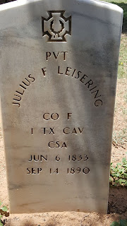
Driving south out of Stanton, we head to Evergreen Cemetery on the southern end of town for our next couple of caches. (GC2V38B & GC31QVK) I don't know much on the history of this cemetery, but one of the oldest headstones I saw was that of Pvt Julius F Leisering who died on September 14, 1890.


A few more caches later and we're driving south from Big Spring, TX on US-87 to our next Geocache (GC1JHNM). Another cool thing about Geocaching is even though you've found a great spot to hide a cache, you may not know its history. But eventually you may come across another Geocacher who does know the story behind your mystery.

That's the case with our next cache. The CO had driven by this place several times and even stopped to look for clues. But could not find out what this place was. However it was still interesting enough to hide a cache here and called it "History's Mysteries." Well five years later another cacher was here to make the find and had the story from a cousin who grew up and still lives down the road. At one time this road and Overton road were the San Angelo highway. The building was a gas station.

A few miles further south and east we find our next two Geocaches (GC3QB8Z & GC1JHMN) for another Texas ghost town. Hyman was on Farm Road 2183 twenty-seven miles southwest of Colorado City in southwestern Mitchell County. It was the site of the last school district to be organized in the county, in 1923 and was named after Mr. and Mrs. Harry Hyman, who donated the school lot. By 1930 eighty students were enrolled from the district, which covered eighty-four square miles. A post office was established at the community in September 1924 with Sarah M. Hyman as postmistress; it stayed open until around 1947, when the town reported two businesses and fifty residents. In 1945 the local school district was broken up and divided by the Colorado City, Westbrook, and Forsan schools. Hyman was the site of a radio navigation station for military aviation. The station was decommissioned with the closing of Webb Air Force Base in Big Spring. In 2000 three families still lived in the community, and the abandoned navigation station, a cemetery, and the ruins of a church remained at the Hyman townsite.


While the last cemetery may be somewhat forgotten and neglected, this next one has an interesting story behind it. Our next Geocache (GC29137) took us to an unknown cemetery of unknown graves. Not too many feet to the right of this photo is an oil well and many more in the surrounding field. The oil field workers discovered these graves, took some of their piping and created a makeshift fence. They try to keep the site maintained as they come to inspect the oil pumps and pipelines.

The story of the graves is that an old stagecoach trail passed through this area. The two theories are a woman and three children or a woman, two children and a dog. Also unknown is how they died. Could it have been Comanche Indians, stagecoach robbers, or perhaps they tried a homestead but failed. We may never know.

Just some sunflowers along the way.
Our final two Geocaches (GC1J0D5 & GC1H3ZW) for the day brought us to the Coahoma Cemetery. Coahoma, Texas, on I-20 ten miles northeast of Big Spring in east central Howard County, probably took its name from Coahoma County, Mississippi, which in turn derived its name from an Indian word meaning "red panther." Early names for the community included Signal Mountain and Signal Mountain Station, after a nearby hill. 


After the 1881 arrival of the Texas and Pacific Railway in the area, Coahoma grew into a retail trade center and shipping point. Its residents built their first school in 1891, and Gertrude McIntyre was the first teacher. By the time its second school was built in 1904, the town had a post office. Machinery and oilfield supplies became the most important goods distributed from Coahoma after the major oil strike of 1926. In 1928 the town had 600 residents, and its school district served 205 pupils. Between 1936 and 1956 the community's population rose from 620 to 802 and the number of commercially rated businesses went from eighteen to twenty-three. In 1960 the population was reported as 1,239, and in 1970 it was 2,000. In 1980 Coahoma had 1,069 residents. At that time the community also had twenty-four businesses, a bank, and a post office. In the early 1990s it was an incorporated community with a population of 1,157 and forty-eight rated businesses. In 2000 Coahoma had forty-eight businesses and a population of 932.

If you spend time looking through this small cemetary you might run accross one of its notorious residents. Texas outlaw Rube Boyce. He was well known in the region as a rustler and robber and was known to have killed at least three men. The El Paso stage followed the Northern San Antonio to El Paso National Road through Fredericksburg, Mason, Menard, and on to El Paso. The route crossed the San Saba River at Peg Leg Crossing, a few miles north of' London. Rube Boyce was adept, as well as habitual, at stopping and robbing the stage in a gap just west of Peg Leg Crossing. A stage driver on that run suggested that a scheduled stop be established in the gap to allow for Boyce's robberies so that the driver could keep the stage on schedule. As mentioned, stage robbing was not his only vice.


Well that was our Geocaching Adventure for today. Lot's of interesting sites and history learned for today. We hope you're enjoying our stories and will see you back soon.