Showing posts with label community center. Show all posts

Sunday, June 13, 2021

2019-07-14: Geocaching Through Texas Ghost Towns, Cemeteries, Abandoned Places and a Train Depot

Welcome back to another episode of my Sunday 300+ mile drive from Central to North Texas while Geocaching through ghost towns, cemeteries, abandoned places, and history. Oh, and a great "Santa Claus Bank Robbery" story too! The passenger seat of the GeoJeep is open so climb aboard and let's go for a backroads roadtrip!


My first stop was just down the road and a quick park and grab cache (GC288JF). Then another quick stop in the old downtown of Lampasas (GC23Z9K). Good thing it's a Sunday morning cause this one is probably harder during the week with activity of muggles around and about. Driving north on US-183, I stopped for two geocaches at the Goldthwaite City Park (GC7VARK, GCTPY1).

Next up was the ghost town of Democrat Community (GC333E9). From the historical marker: "Although settlement of this area dates to 1878, this graveyard was not established until the turn of the 20th century. The earliest documented grave is that of one-year-old Lee Ella Deen, daughter of W. F. and M. L. Deen, who died in November 1904. In February 1905, J. L. Chancellor deeded the surrounding three acres of land to the citizens of the Democrat and Rock Springs communities for use as a public burial ground. Among the early graves in the cemetery are those of a number of infants and children, victims of the influenza epidemic that raged worldwide in the early 20th century, and veterans of the Civil War, World War I and World War II. A reflection of area history, the cemetery remained in use at the turn of the 21st century."

The church across the road from the cemetery is used as a community center now by the few remaining residents of the Democrat and the Rock Springs Communities.


Driving further up into the town of Comanche, I arrived for my next geocache at the old train depot (GC6H0EC). Comanche was established in 1858, when Captain John Duncan offered the county 240 acres on Indian Creek as a site for a county seat. The commissioners' court accepted the donation, and Ransom Tuggle was authorized to lay out the townsite. T. J. Nabors built the first house. The new town replaced Cora as county seat in May 1859. The first courthouse was a "picket house"—a structure of logs cut and split on the ground, set vertically in a ditch, and covered with boards also made on the ground. The post office was established in 1860 and a newspaper, the Comanche Chief, began publication in 1873. The town, a supply base for Texas ranches during its early history, was incorporated in 1873.


By 1892 Comanche had 2,500 residents, the Fort Worth and Rio Grande Railway, a daily stage, and numerous businesses. By 1915 the population was 4,500, and the town was a flourishing farm-market center and transportation center. Over the years the population would fluctuate down to as few as 3,415 and back up to nearly 4,500 again.

This geocache was a 2-stage multi-cache. I obtained clues at the train depot to figure out the final coordinates of the cache container which was located at the town's Oakwood Cemetery. When Captain John Duncan this land to establish the county seat, he specified sufficient portions be set aside for a graveyard, churches, and schools. A cemetery of about 6.5 acres was established and named Oakwood for the impressive oak trees growing on the site. The earliest marked grave is that of one-year-old John Neely, who died in January 1861.

The one grave that caught my eye was of M.R. (Boss) Greene (10-14-1843 to 5-12-1877). He was a Deputy U.S. Marshall who pursued  Dee and James Bailey for passing counterfeit quarters in Comanche. After a 10-mile chase, he captured and disarmed the brothers. Catching Greene off guard because of an unruly horse, one prisoner took Greene's rifle and shot him. He returned fire with his hand gun but was fatally wounded in the exchange. The prisoners escaped only to be recaptured and hanged on a live oak tree here in the cemetery where Greene is buried.


The next geocache was at the Amity Cemetery (GC2YQ7R). From the historical marker here: When 14-year-old Charles Farley died in Feb. 1878, his parents buried him near their farmhouse, as this frontier locality had no cemetery at the time. Three months later Fannie Nichols (1875-78) died and was buried nearby. The Farleys then donated an acre of land as a community graveyard. The neighbors built an adjacent brush arbor for funerals and general gatherings. In the summer of 1878, Baptists organized a church, naming it Amity (friendship). Before erecting their own buildings, Baptists and Methodists held services in the brush arbor or at Amity School (1 mi. NW).

William H. Lindley (1840-1913) bought land south of the Farley Farm in 1885. When new surveys placed the cemetery on his land, Lindley deeded the burial ground to the public. Later his son-in-law, George Brown, gave an additional acre to be used if needed. A large tabernacle with permanent fixtures replaced the brush arbor and was used for funerals until 1938 or 1939, when it was severely damaged by a storm. Free-will donations have maintained the cemetery since 1951. A "First Sunday in June Singing" which Amity Baptist Church originated in 1897 now serves as an annual memorial day and homecoming. By 1978 Amity Cemetery has nearly 400 graves.

On the way to my next stop, and one of the things I like about driving the backroads, was this unexpected picturesque scene of the giant hay wheels sitting on this green pasture. Contrast with the blue sky and white clouds I just had to stop and capture the photo.


Up US-183 north of Rising Star, Texas was this abandoned building. I couldn't find out anything about it and couldn't decipher the name on the front. I also couldn't find the geocache on the side by the tree either (GC5M0MG). Looks like it may have been a store or gas station. Someone even suggested it looks like it could have been a post office. Got a lot of stuff stored inside now.


Also nearby is the Romney Lutheran Cemetery geocache (GC1HMM2). It's a small rural cemetery with less than 100 interments. The earliest known marker dates back to 1901. The town of Romney was established in 1880 when former West Virginian J.W. White arrived and named the community after his former hometown. The community was granted a post office in the early 1890s which remained open through 1931. Romney had always been an agricultural community, primarily cotton. At the turn of the 20th Century, it had most essential businesses as well as a school. A boll weevil infestation in 1914 curtailed growth although it limped along into the 1960s when it still had a gas station and two stores. The 1940 population was given as 40 residents. A slow decline drove this number down to a mere 12 by the 1980 census - where it has remained.


To the east of Romney was the Long Branch Church and Cemetery geocache (GC1KEEB). Formerly organized on July 16, 1885, the Long Branch Baptist Church held its first worship services in an old schoolhouse on land donated by R. B. Covington. The thirteen charter members were served by W. B. Cobb, the church's first minister, until August 1886. Missionary pastors continued to hold monthly services over the years. The congregation, which built its first sanctuary on this site in 1905-06, has provided significant service to the Long Branch Community and the surrounding area throughout its history. The cemetery has nearly 700 interments dating back to 1882.


Then there was also the Pleasant Hill Baptist Church and Cemetery (GC7G2XZ) near the town of Carbon. The few original charter members met in the old Pleasant Hill Schoolhouse in 1892 and organized the Pleasant Hill Baptist Church. Although the first church structure, built in 1905, was destroyed by fire later that year, another was erected in 1906. A new structure was also built in 1945. Several pastors of this church have also held eminent positions at institutions of higher learning in the area. This congregation has remained active in community and mission programs. The cemetery has just over 300 interments and dates back to 1904.


Heading back towards US-183, near the intersection is a TXDOT sign which displays the distance back to the town of Carbon. There's also a geocache near the sign (GC12CTF). I'm glad someone at TXDOT has a sense of humor for the properly distanced placement as well as the geocacher picking this spot to hide a cache. Now I'm thirsting for a carbonated beverage!


My second to last stop of the day was another cemetery geocache in Cisco at the Oakland Cemetery (GC3M5V5). With over 7500 interments located in this cemetery dating back to the 1870's. There are two that I want to bring to your attention: Sheriff George Emory "Bit" Bedford and Deputy George W. Carmichael. They were mortally wounded during what was called the "Santa Claus Bank Robbery" of 1927. Around noon on December 23, 1927, four men dressed up at Santa and attempted to rob the First National Bank of Cisco, Texas. At the time it was one of Texas' most infamous crimes and led to the largest manhunt in state history.

Because of the numerous bank robberies that took place in the recent months, the Texas Bankers Association announced a $5,000 reward for anyone shooting a bank robber during the crime. So when a bystander managed to escape early during the robbery and shouted out into the streets to get the attention of law enforcement, that also attracted anyone and everyone with a gun to assist in taking down one of the four Santa's. There is more to this story, though a quick read, and I encourage you to click the link in the previous paragraph and read the entire account at the Texas State Historical website. You'll be glad that you did!


Continuing north a couple miles out of Cisco, I spotted a cemetery sign and had to investigate further. This small unkept cemetery was called Reagan Cemetery and according to the FindAGrave website contains 14 burials. Though I don't know why it called Reagan as there are no Reagans' buried here. Nor could I find any information about a town or community in the area called Reagan. The oldest is dated 1879. There wasn't a geocache here, so I hid one myself (GC8BNM4) to bring others to this forgotten cemetery.


So that was it for stopping. It was already after 5PM and I still had 100 miles of driving to go. Along with getting a bite to eat, going to the grocery store so I have lunch for work tomorrow, etc etc. Thanks for riding along and I hope you come back again for another geocaching adventure.

Tuesday, December 31, 2019

Exploring the Ghost Town of Girvin, Texas and Hiding a Few Geocaches

For my blog post for today, I thought I'd do something a little different than usual. Instead of me finding geocaches and seeing interesting places, this is about me finding an interesting place and hiding caches there.

Shortly after arriving in West Texas in early 2016, I started working in construction on a solar farm just south of Girvin, Texas. Passing through here every day going to and from work, I would often stop and explore a little more as I noticed different buildings. I also researched the internet to find it's history. And on one occasion, I had the opportunity to talk to one of the locals there and learned a rather interesting story which I'll reveal in a moment.

Old Store July 2016

Surprisingly there weren't any geocaches here. As a matter of fact, the nearest cache was at a picnic area four miles up the road. Then ten more miles beyond that. As I learned more and found more I began hiding geocaches so that other geocachers could also learn of Girvins' history.

So going back in time; a community, originally named Granada, began there in the 1890's when cattle ranchers moved into the area. In 1912, the Kansas City, Mexico and Orient Railroad completed track construction from Mertzon after crossing the Pecos River. A post office was established on January 31, 1913 and the town was officially named Girvin, after local rancher John H. Girvin. The original town site was located on both sides of the tracks, near the rail station. You can see in the second photo below where I think that train station was once located by the raise ground and old railroad ties lay where perhaps a separate track once was for loading and unloading.

Some of the remaining buildings can be seen through the mesquite on the right.
August 2016
Was this where once laid tracks for the train depot?
August 2016
Old water tower for the steam engines.
August 2016
Soon after the railroad began stopping, the town grew and had a store (pictured at the top of the page), a hotel, a saloon, and a lumber yard. Stock pens were built nearby while awaiting shipment. You can still see some remnants of those below. Look hard enough in the photo and you can also see the geocache I hid there as well (GC6PCFM).

Stock pens. July 2016
Eventually as more and more automobiles arrived in West Texas, you needed a gas station and garage (GC6P64R). The building in the photo below used to be two stories. The gas pumps and shop below, and storage and perhaps even living quarters above. I've seen photos from as recently as 2000 that still showed walls for the second floor above the fuel island to halfway back. Sometime after that an arsonist set fire to the place and that came down.

Remains of the gas station and garage.
May 2016
The first school was a small wooden building. In 1924 Girvin had an estimated population of only 15. In the late 1920's, with the production of oil in the nearby Yates and Trans-Pecos oilfields, Girvin became a hub for the delivery of equipment, supplies, and workers with families. A larger brick schoolhouse was being constructed and was already proving to be too small as one class had to meet in the lumberyard during the 1930-1931 school year. Oddly enough though, that is the one public building that is still maintained today. It is used by those few remaining residents as a community center and voting place (GC6QRXC).

Former school, now a community center. August 2016
Unfortunately, in 1933 a new highway from Fort Stockton to McCamey bypassed the original townsite about a mile to the south, and Girvin immediately began to decline. The community reported five businesses and a population of seventy-five in 1939. In 1944 the Panhandle and Santa Fe Railway, which by then owned the track through Girvin, razed the section of the Girvin depot used for freight; and the passenger station was closed in 1955. By 1963 the estimated population of Girvin had declined to thirty, with only two businesses reported. And by 1967 the original townsite was abandoned all together. A few of the businesses and residents had moved down closer to the highway (now US-67), but even they eventually left. In 2000 the population at the new site was still estimated at thirty.

One of the those businesses which remained open until the very end was the Girvin Social Club (GC6P62F). This small red building was once a popular place. A cafe and saloon, it finally shut it's doors in 2011. The first pic below is a painting of what it looked like in it's peak. The second photo is what I saw back in 2016. Now, I'm back working on another solar project west of Girvin and am happy to say that it's back open again as McKee's Bar.


The Girvin Social Club July 2016
McKee's Bar December 2019

I read another article about a Arno and Mildred Helmer purchased the railroad depot in 1956 after it closed. Then moved it down near the new highway where they opened it as the Girvin Store and Post Office. That was where most of the traffic was passing through now. It was also remodeled so that the Helmer family could live in it as well. It was said to be next to the Social Club and these two buildings are across the street on the next corner. I'm not sure exactly which one it was, but my guess was that it's the white building below. There was also a gas station on the corner and that would fit more of the yellow building with the rail car. I'll need to stop at the bar one day and see if any of them know. I do know that the yellow building below is where some of the remaining residents meet on Tuesday nights, hang out, and play poker.

Maybe former gas station? December 2019

Perhaps the former rail station converted to post office, store, and house.
December 2019

And finally I come to the Girvin Cemetery (GC6QRW8). While there are dozens of graves there, most are unknown and are just iron crosses. Only six still have headstones which have names and dates. And it isn't maintained. The few headstones that are identified range from 1917 through 1941.

Now remember at the beginning I told you that I talked to one of the locals when I first started working nearby in 2016? One of the interesting headstones is a double sided headstone for J. W. Steele and J. P. Ryan who both died on Feb 9, 1927. I Googled the names but came up empty. I heard the story from the resident about 2 boys who were passing through town and killed in a car accident near one of the Pecos River bridges. They were buried as unknowns before the families came looking for them several months later. The families followed the route towards their intended destination asking people if they remembered seeing them. The people of Girvin told them the story of the accident and they matched the description. Could these be the two boys? I don't know. I haven't been able to confirm the names or date. If you have any information to add, please forward it to me.


Girvin Cemetery August 2016

Update 03-19-2020: I found a newspaper story from the Fort Worth Record-Telegram dated March 1, 1927. The first sentence doesn't make sense to me, but I'll post exactly how it's printed:

ANOTHER BODY FOUND IN PECOS
Two Men Identified as River Recedes
and Discloses Second Victim of Mishap.

"SAN ANGELO, Feb 28, -- The with a wound on his forehead and the Sunday in the Pecos River at the Girvin bridge, according to late advises today from McCamey. Both Ryan and J.W. Steele, pipe line workers for the Southern Crude Oil Purchasing Company, met death when their roadster missed the bridge on a curve in a rain and sleet storm and was hurled into the stream.

"Steele's body was found Friday and a wound on his forehead and the absence of money led to a search for a companion with whom Steele was said to leave McCamey for Pyote. This man's identity was not known until the second body was found. Besides a time check identified as Ryan's, there was about $50 in his pockets. Receding of the water three feet disclosed the submerged car Saturday."

August 2016

August 2016
Well that's about it for my trip through historic Girvin Texas. I'd like to recognize a few websites recommend them to you for even more information: Texas State Historical Association and TexasEscapes.com . Both of these are excellent resources for Texas history. And as always, be sure to Like my https://www.facebook.com/AwayWeGoUS page or follow my blog directly using the buttons on the right column of this blog. Until next time...

Saturday, March 12, 2016

2016-03-11: A Canceled Appointment Means Geocaching Through Cemeteries

So this coming weekend was to be moving day. Candy's term at the facility in Lubbock has ended and she's transferring down to Monahans, Texas. The office for the next apartment complex was closed on weekends so today I was going to drive down and pickup a key to move in on Sunday. Well above halfway down, I received a phone call from them and we would have to wait until Monday. So I made a u-turn back to Lubbock.

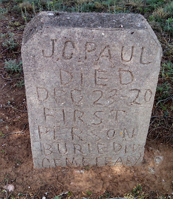
But not all was lost. Might as well do some Geocaching on the way back! I stopped by the O'Donnell Cemetery (GC4X8H7) just south of the town of O'Donnell. Couldn't find much information about the cemetery itself, but did see some interesting headstones. The earliest dates back to 1920 and J.C. Paul. There were a lot of babies and small children, many of which were undated like the photo.

Front gate to O'Donnell Cemetery.

Headstone that reads "BILLINGTON INFENT"

Headstone for J.C. Paul who died December 23, 1920 and the first person buried in the O'Donnell Cemetery.

The next Geocache and cemetery was the Hancock Cemetery in Dawson County (GC5HGW3). Again not being able to find the history of the cemetery except the date of 1925 on the overhead entrance gate. There were some interesting headstones in there as well.

The front gate to the Hancock Cemetery in Dawson County.

The headstone for W.B. Foreman who died March 8, 1925 and buried in Hancock Cemetery.

A rather interesting headstone located in the Hancock Cemetery Texas.


In the town of O'Donnell, Texas was another Geocache (GC509PA) next to this abandoned food store. An interesting old building and on the front facade you could still make out the partial name of "O'Donnell Food." Possible a grocery store, but looking inside I saw a lot of cages and written on the inside wall the statement: "NOTICE ALL PROCESSING CHARGES MUST BE PAID WHEN MEAT IS PICKED UP!" Could it have been a butcher or meat processing place? I'm not sure.

A photo of an old abandoned business in O'Donnell Texas.

A photo of an old abandoned business in O'Donnell Texas.

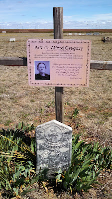
The next stop was at the Plain View Cemetery (GC5MB7G) and my next Geocache. Again I wasn't able to find any history of the cemetery, but there were some headstones dating back to the early 1900's. The one of most interest is that of PaNaTa "Netty" Alford Gregory (April 29, 1937 - August 29, 1912). Daughter of Puchethi and Fernaty Alford, Granddaughter of Shawnee Chief Tecumseh and Manete, great grand-daughter of Chief Pucksinwah and Methoataske.
The front entrance gate for the Plainview Cemetery in Dawson County Texas.

The headstone for PaNaTa "Netty" Alford Gregory buried in the Plain View Cemetery Texas.

My last cache for the day was at the Plains Community Center GCN5VB). Plains, Texas, which is not to be confused with Plains, Texas the Yoakum County seat, is a tiny community located in northwestern Borden County to the northwest of Gail near the small ghost town of Mesquite. It was an old farming community that was once home to a functioning school. That school house is today a community center. Though looking in through the windows, probably hasn't been used in a long time. Still has the old style steel swings and slide in back, definitely not safe by todays' standards!

The Plains Community Center and former schoolhouse.

A photo of the old playground set behind the Plains Community Center.

Across the street was another old abandoned building in deteriorating condition. I didn't see any signs or anything giving away its long ago purpose. Taking a peak into the windows, there were a couple of old appliances, pallets, and wood piles. The ceiling and pieces of the roof had fallen and laying on top of everything so it just looked like a pile of debris inside. But based upon the layout, I'd say this was once a church. But once again, I couldn't find any information on it.

An old abandoned and dilapidated church building in Plains Texas.

Enough Geocaching for today. Time to get back home.