Saturday, August 28, 2021

2019-12-28: Spending the Day in Big Bend National Park

It's been 13 years since I was last here at Big Bend National Park in West Texas. Spending the last few years just a few hours north of here, I figured it was about time I paid another visit. We spent two nights in Alpine, TX as our base so we could get here early, stay all day, and not have a long drive home afterwards. Big Bend NP is over 1200 square miles and that's a lot to explore and see. So let's get going!


We arrived just after dawn to a cloudy morning which kinda hindered having some great sunrise photos. Our first geocache was an earthcache called "Fins of Fire" (GC3AZVV) facing the Chisos Mountains to the east, describing the layers and spikes and the creation of the mountains from volcanic activity.


Continuing the beautiful route down the Ross Maxwell Scenic Drive, we arrived at the Solol Vista Overlook and another earthcache (GC2NJRH). The amazing views here are awe inspiring. And from this vantage point we barely get a glimpse of our destination Santa Elena Canyon some fourteen miles in the distance. From here though it's just a tiny notch in the mesa across the valley.


In the panoramic photo below taken from the Sotol Overlook, from left to right are: Trap Mountain, Goat Mountain, Santa Elena Canyon, Kit Mountain, across the valley to Tule Mountain, Burro Mesa, Little Christmas Mountain, and Christmas Mountain.


After the overlook, we stopped at Tuff Canyon for another earthcache (GC72D1C). Tuff Canyon is the deepest of the dry washes in Big Bend NP. This also makes it very dangerous during or after a rain as the gathering waters pick up velocity and can cause a flash flood rushing between the canyon walls. Over time the rushing waters slowly dig a deeper channel while at the same time eroding and smoothing the layered rock walls.


The mountains and cliff walls are plentiful. Just driving the roads, you won't even need to get out of your car to be amazed at the views.


Now we get to the Santa Elena Canyon observation area (GC37ECH). The Santa Elena Canyon is one of the most famous landmarks within Big Bend National Park. Looking from the overlook area, that's the United States on the right, Mexico on the left, and the shallow Rio Grande River flowing up through the middle and curving to the left. A lot of people stop there to get their photos. However if you keep following the road around, it will take you down to the entrance, or should I say the exit.


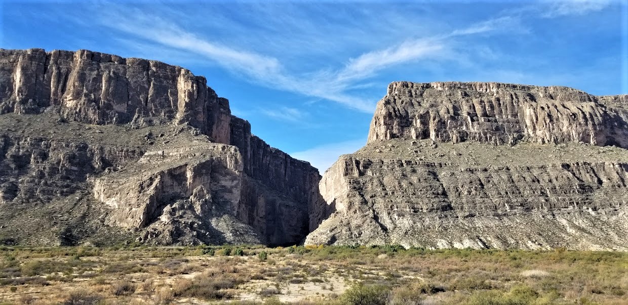
Where the Rio Grande exits the canyon, there's the Santa Elena Canyon Trailhead. The Terlingua Creek drains into the Rio Grande River just as it exits the canyon. You can see it in the next photo coming in from the left. Most of the time the water level is low enough and you can easily walk across rocks without getting wet. Once you cross over and climb the short hill you enter the trailhead that has been paved creating an easy hike with stairs and switchbacks up 160 feet to the point from which I took the photo.


Once you make the short hike up and over at the trailhead, you make your way down the trail into the cool canyon. Because of the 1500 feet canyon walls that seem to raise up forever, they block out the sun except for the short time it is directly overhead. We continued our hike down and back to see how far we could go. Officially it's a 1.5 mile out and back hiking trail.


At this point, we came to the end of the trail. This is about as far as you can hike without getting wet. Now I was wanting a kayak so I could keep going to see what's around the corner. One of these days I just might do that.


Backing up a little ways there's this huge rock that had fallen near the edge of the bank of the Rio Grande. I talked Candy into climbing out on the rock with me and handed my phone to another hiker to take our photo. I think this turned out much better than trying to take a selfie and still get the full canyon effect.


Having made our way back in the GeoJeep, it was time to hit some of the offroad trails. First we drove back up the Ross Maxwell Scenic Drive and looped around over to the Panther Junction Visitors Center. This time we finally bought one of those National Park Passport books that you get stamped each time you visit a national park or historical site.

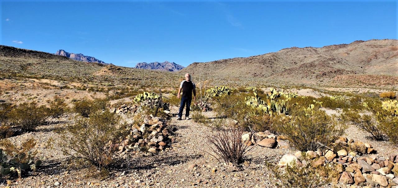
From there we made our way down to Glenn Springs Road. It's a gravel road that even a regular car can make it through, see the first pic at the top of the blog. There might be some parts that may be a little rough, but I'd drive down most of it if I still had the Prius and the turn around if I got to an impassible section.

After several miles it turns into Black Gap Road as it nears the spring. There it does become a rougher section that really requires high clearance vehicle. Just past the Glenn Spring primitive campsite I found my next virtual geocache (GCR2A8). The U.S. Calvary once used this location for a few years. If you look hard enough you can still find parts of the foundations of some of the buildings. At the top of the nearby hill you'll find some scattered wooden crosses for the cemetery. To get credit for finding the virtual cache you need to email the number of crosses. The Find-A-Grave website only lists five memorials here. If you use that number you won't have the correct number as there are more than that. And not having any names on the wooden crosses, they are known only to God.


Another hour or so of offroad fun in the GeoJeep and we make our way to the exit roads and back up to Alpine, Texas. It wasn't until later that I realized the Black Gap Road was one of the trails in the Jeep Badge of Honor series. If I had used the BoH app to check in from the trail, I could have gotten my first badge. Oh well, I guess that's a good excuse to have to come back and explore some more of the Big Bend National Park. There is still much to see out here that I haven't gotten to yet. And I recommend this place to be put on your bucket list one day. Just try to avoid summer as the temps are easily in the triple digits!

To follow along on our travels and keep up with my latest blogs, you may do so here of course. But also by using you favorite of these social media platforms: FacebookMeWeGabRedditParlorTwitter, and Instagram. These all link directly to my profile. Again, please feel free to comment and / or share.

Saturday, August 21, 2021

2019-12-24: Visiting the Iwo Jima Monument... in South Texas?

Hey everybody! Well this is a short and sweet blog post. I had some personal business to take care of way down in South Texas in a town called Harlingen, not too far from the southern tip near Mexico. I did want to highlight a couple of places here though. I bet you're probably wondering about this first photo though. Why are you using the Iwo Jima statue pic in a blog about south Texas? Because the original... well I'll get to that in a minute. We haven't left the hotel yet this morning!


So when making reservations on South Padre Island, the "ocean front" rooms were all booked. OK, so second best thing is the "ocean view" rooms. When we arrived last night it was already dark and couldn't tell the difference. This morning I look out and really? Ummm really? Where's the water? Maybe if it rained hard and the parking lot next door flooded! Oh well, just stayed the night anyway. Gotta take care of business and hit the road.


Down the block, I saw this gift shop and just had to pull in for a photo opp with the GeoJeep! Saw something similar in Myrtle Beach, SC and backed the Jeep up into the mouth. This place was open already so I decided not to.


After the quick personal business stop in Harlingen and breakfast at IHOP, we drove over to the Marine Military Academy near the Valley International Airport for two great geocaches. The first was a traditional cache hidden under a tank-like "Expeditionary Fighting Vehicle" (GCMT90). I was so focused on the main attraction, that I forgot to get a pic of it!

The Iwo Jima Monument located in Washington D.C. wasn't the original monument. On Feb 19, 1945, Marines invaded the island of Iwo Jima, a Japanese stronghold in the Pacific. Two days later, Marines reached the top of Mount Suribachi and a small American flag was raised. Later, on the same day, a larger flag was raised by six Marines. Associated Press photographer Joe Rosenthal captured that flag raising on film. A few days later it was published in Sunday papers across America. Sculptor Dr. Felix W. de Weldon, then on duty with the U.S. Navy, saw the photo and constructed a small scale model within 48 hours.


After the war, Dr. de Weldon worked for 9.5 years to create a full size model from molding plaster. The survivors of the flag raising posed for the artist to create their faces. Photos and physical descriptions of the three who gave their lives were used in modeling their faces.

Once completed in plaster, the statue was disassembled and shipped to Brooklyn, N.Y. to be cast in bronze. It took 3 years for the casting process. The bronze parts were then shipped to Washington D.C. for erection in Arlington National Cemetery. The plaster working model was shipped to Dr. de Weldon's studio in Newport, R.I. The U.S. Marine Corps War Memorial was dedicated on Nov. 10, 1954.


In October 1981, after much consideration, Dr. de Weldon gifted the original working plaster model to the Marine Military Academy in Harlingen, TX. This site selection included: 1. Fairly consistant temperature and humidity for preservation of the molding-plaster figures. 2. The street facing the memorial was named Iwo Jima Boulevard in 1965. 3. The MMA is the only place outside of Washington D.C., where proper honors are rendered with battalion-size dress blue parades. 4. The Marine placing the flagpole into the ground was a native of the area, Cpl Harlin H. Block. Block's gravesite resides directly behind the monument. Cpl Block was killed during continued fighting on Iwo Jima only a few days after the flag raising. .

The Iwo Jima Monument was dedicated April 16, 1982 on the MMA Parade Ground. It is coated with fiberglass for weather protection. And now it is also a virtual geocache 
 (GC7B6ED).

From there it was a long 6 hour drive back to Killeen, Texas so Candy can spend Christmas Eve and morning with her grandkids. Then later Christmas Day driving to McCamey in West Texas for work on Thursday. I'm exhausted! I need to go back to work to get some rest! See ya next time...

To follow along on our travels and keep up with my latest blogs, you may do so here of course. But also by using you favorite of these social media platforms: FacebookMeWeGabRedditParlorTwitter, and Instagram. These all link directly to my profile. Again, please feel free to comment and / or share.

Saturday, August 14, 2021

2019-11-25: Our Return to Hiking the Lighthouse Trail in Palo Duro Canyon Texas

Welcome back friends, family, geocachers, RV'ers, Jeepers, and everyone else who just happened to drop by my AwayWeGo's Geocaching Adventures blog. This is more about just geocaching though. I'm here to share my travels around this great country. The geocaching just helps me find some of those out-of-the-way very rural backroads "not-on-your-tourist-map" great sightseeing treasures.

If you'd like to follow along via many of the social media sites. I'll provide links at the end of this blog. I'd also love to hear from you, so please feel free to comment here or on the social sites. And please by all means share my stories with your friends too. I hope my stories inspire you to get out and explore.


Well after my opening paragraph, today we DID do the touristy thing and return to the Palo Duro Canyon. We both had this Thanksgiving week off so we decided to take a drive up to Amarillo, Texas and do some hiking in the Canyon. We were here a few years earlier to make this hike and that's where I proposed to her. (see "She Said Yes!") We've been married now for just over three years.

Plus along the hiking trail up to the famous rock formation called The Lighthouse, there was a trail of geocaches hidden. Many of those caches had been missing and we had to DNF them. They've since been replaced and now we can redeem those DNF's.


The weather couldn't have been better! It was cool out and with sunny skies, it made for perfect hiking. It also made for some pretty good photos I think. This next photo I call Sitting Chief. I don't know if it has an official name, but that's what I think of every time I see it.


Some background info from the Palo Duro website: The history of the canyon goes back a long ways. The Clovis and Folsom peoples first lived in the canyon and hunted large herds of mammoths and giant bison. More recently, the Apache, Comanche, and Kiowa took advantage of the canyon's plentiful resources. These early cultures left behind rock art and bedrock mortars where they ground mesquite beans and roots for food. The early Spanish explorers probably discovered the canyon and called it Palo Duro, Spanish for Hard Wood.

The Red River War between the U.S. Army and southern Plains Indians lasted from June 1874 to the spring of 1875. A decisive battle occurred in the canyon on Sept. 28, 1874. Colonel Ranald S. Mackenzie led the 4th U.S. Cavalry in a surprise attack at dawn on a camp of Comanches, Kiowas and Cheyennes. The families fled up the canyon, leaving everything behind. MacKenzie’s troops captured 1,400 ponies and shot most of them. Soldiers also burned all the teepees and winter stores. With no horses or supplies, the families had no choice but to return to the reservation. The reign of Native Americans over the Panhandle plains ended soon after.


Charles Goodnight, a former Texas Ranger, drove 1,600 Longhorn cattle to Palo Duro Canyon in 1876. He and his partner John Adair, an English aristocrat, founded the JA Ranch in 1877. At its peak in 1885, the ranch grazed 100,000 head of cattle on 1,325,000 acres spread across the Panhandle. After Adair died, his widow, Cornelia, took over as Goodnight’s partner. In 1887, Goodnight decided to scale back his ranching activities. The partnership ended that year, and the partners divided the land. Most of the canyon belonged to the JA Ranch up until 1890. Adair descendants continue to run the JA Ranch today.

The state bought the land for the park from Fred S. Emory in 1933. Soon after, Civilian Conservation Corps workers arrived, and spent the next five years creating a park. First, they built a camp for their home base, and then they set to work in the immense canyon. The men built the winding road to the canyon floor. Until it was finished, they hiked in and out of the canyon on what is now the CCC Trail. CCC workers made all of the park’s original improvements, including El Coronado Lodge (now the Visitor Center), the cabins on the rim and canyon floor, and trails. Designers planned the park to maximize views and complement the surroundings. The CCC used local stone and wood for building materials. In addition, workers forged decorative metal and crafted furniture. The park opened in 1934 before it was complete. It is the second largest park in the state parks system today, with about 28,000 acres


So of the 6 or 8 remaining caches along the trail that we needed to find, we only DNF'd just one... again. Since our last visit there was added a virtual geocache (GC7B6H7) and an earthcache (GC81YE8) up at Lighthouse Point. Upon arriving, we did the obligatory oohs and aahs, took in the views and captured some photos. Then after a short time we hunted for the answers for the caches before descending down into the canyon for our hike back to the parking lot. It is a beautiful Texas State Park and one of my favorite places in the country. I'm sure we will be returning again often.


I hope you have enjoyed our visit today to Palo Duro Canyon up in the panhandle of Texas. To follow along on our travels and keep up with my latest blogs, you may do so here of course. But also by using you favorite of these social media platforms: Facebook, MeWe, Gab, Reddit, Parlor, Twitter, and Instagram. These all link directly to my profile. Again, please feel free to comment and / or share. Until next time... see you out on the road!

Saturday, August 7, 2021

2019-09-02: Back to West Texas and Finding Geocaches in San Saba, an Old Suspension Bridge, Cemeteries, and a Funny Story

Ugh.. Back to West Texas Again!! Well my time in North Central Texas is over. I had plenty more places to explore and geocaches to find. But I gotta go where the job tells me to go. They needed a surveyor to start a new solar project in McCamey, TX, so I trained my replacement at the wind farm in Gilliland.

I think I have found almost every geocache between Killeen and McCamey, so I'll probably be driving WAY outta route to find some caches and places to explore. So who's ready for a roadtrip? Hop in the GeoJeep and let's get going.


My first stop is taking the rural FM 580 backroad west of Lampasas. Wasn't anything to see here. Just a backroads geocache out in the middle of nowhere (GC15R7W).

Arriving in San Saba, Texas to the Welcome sign on the south side of town, I was greeted by a unique cache container (GC729ET). This cleverly disguised micro cache might be easily skipped if attempting at night.


One block off the main street through town is this 100 year old Methodist Church and my next geocache (GC7285N). I had been wanting to get this one the previous times passing through San Saba, but it is usually a Sunday and the busiest day of the week for this building. On this morning there were still some folks around front (so no photos), but in back where the cache was it was deserted. Found it in short order and continued on my way.

One more stop for the San Saba Cemetery (GC727WY). Previously the Odd Fellows Cemetery, it is located on 17 acres of land about 800 yards north of old town San Saba. On April 18, 1883, the San Saba Chapter of the Independent Order of Odd Fellows (IDOF) purchased 10 acres of this land from J.J. Stockbridge to establish a cemetery, which they maintained for 45 years. On April 3, 1929, the newly incorporated San Saba Cemetery Association purchased the cemetery for $1.00 and an additional 7 acres from Mrs. May Holman, also for $1.00. In 1935 burials from San Saba's earliest City Cemetery, now Rogan Field, were reinterred here.

Once again on the rural backroads north of San Saba, county road 500, I stopped at this cross on the side of the road. Eighteen year old David McBride is buried in the above cemetery, but I can only assume that this roadside memorial was the location where his life was taken so soon.


Continuing up the rural backroads on the way to my next trio of caches, I saw all these beautiful purple plants. They look like mini-pineapples, but very sharp prickly thorns all over them. After taking some photos, I drove on.


The next three geocaches were all in the vicinity of the Regency Suspension Bridge. (GC1A7VT, GC1A1DW, GC1A1DM) Built in 1939 mostly by hand and restored 60 years later in 1999, the Regency Suspension Bridge spans 325 feet from tower to tower. The towers rise 30 feet above the bridge floor, which is 16 feet wide. Engineers list the overall length at 403 feet. Locally known as "The Swinging Bridge", it connects San Saba and Mills Counties across the Colorado River. On December 29, 2003, vandals set the wood surface on fire burning a whole through some of the 4x12 inch planks. Thankfully the bridge was once again repaired. After enjoying the views and taking lots of photos, I was able to find 2 of the 3 geocaches. (08-09-2021 UPDATE: I'm being informed that vandals have struck again and set the bridge on fire and has been closed to traffic.)


Working my way through the maze of gravel roads back south trying to find civilization again, I spotted the Mesquite Cemetery. This small yet maintained cemetery dates back to 1885 and has less than 100 burials. I didn't have it saved in my phone so there wasn't a geocache already here. And unfortunately I didn't have any ready to hide, so it looks like another drive up through here in the future is in store.


My last stop for the day was a geocache (GC2QDCK) along US-190 between Fort McKavett and Eldorado at the intersection of Hwy 2084. More commonly known as the "Toe Nail Trail." Now I've found a lot of references to the "Toe Nail Trail" including a historical marker for Christoval, TX. But as far as a history as to it's name, well there is a ranch called the Toe Nail Ranch. Other than that, all I got to share is what is written on the geocache page. And it's pretty good, so I'm just gonna give it to you word for word. So kudos to cacher Tres Compadres for the description:

"Howdy Pardner,

"My moniker is Handy Hank. But ah answer to most anything, ‘specially when an invitation to share some grub is involved.

"Welcome to Toe Nail Trail. In the late 1880’s, folks a-traveling’ up to Christoval from Scabtown-- That’s what they called that collection of brothels and saloons that “serviced” Fort McKavett ‘afore it became respectable-like and re-named itself Fort McKavett -- had to follow a trail fifteen miles north of the old fort through the Toe Nail Ranch. The ranch, by the way, was named “cuz it angled in a funny way across the corner of the county. Them people in Austin done give the trail a number. Don’t rightly recall what it is. Nothing interesting about a number. Pshaw, most folks still call it Toe Nail Trail and iffen ya ask for it by that ridiculous number, you likely to get a blank stare. Lotta folks have traveled this route over the years and still do. Give ‘em a wave iffen you see some while yer out thar.

"Now, I’ll be helping you with this here Challenge that the Tres Compadres done cooked up. Well, sorta helping you. You’ll find me sharing tidbits of information about the Old West and some of the characters that populated these parts. Pay close attention to what I say, that information might just come in handy along the way. Ya’ll know how that devilish Mommio likes to hide crucial bits and pieces of information from you. And this challenge ain’t no different from her past scribblings. And then there are those clever caches that Mermaid and Horny Toad are known for, expect more of them to show up along the trail.

"Yer journey along this trail from one end t’other, will bring you to all the caches them folks placed for yer entertainment. Ya’ll have to take a side-trip or two down some dirt tracks that lead offen the trail but mostly ya’ll find yerself on the main road. Hopefully, ya won’t be a-meeting up with any o’ the ghosts o’ some o’ the characters that trekked up and down the old trace but keep a sharp eye out for ‘em. A goodly number of them were purty disreputable.

"Ya’ll be careful out there."

Well I hope you got a chuckle out of that one. IF you can decipher the accent on some of the words. That was my adventure for this day. I hope to see you again soon.