Showing posts with label history. Show all posts

Saturday, August 19, 2023

2021-05-30: Visiting the Notorious Bonnie and Clyde Hangouts and Graves in Dallas, Texas

Welcome back friends, geocachers, RV'ers, and fellow travelers. On this particular roadtrip adventure, we were passing through Dallas, Texas and decided to take a break from the driving. We set out to retrace some of the stomping grounds of the infamous Bonnie and Clyde with the help of a Geocaching Adventure Lab. The couple became national news figures as they traveled the mid-west from 1932-1934, with their criminal gang during the Great Depression. Just about everyone has heard the story or seen the movies. Now let's go visit some of their hangouts around West Dallas...


Clyde Chestnut Barrow was born in 1909 into a poor farming family in Ellis County, Texas, southeast of Dallas. The family moved to Dallas in the early 1920's as part of a wider migration pattern from rural areas to the city, where many settled in the urban slum of West Dallas. The Trinity River Squatter's Camp was the industrial slum along the river bank underneath where the current Margaret Hunt Hill Bridge is now located. Back during the depression, the area you see below was a maze of tents, wagons and makeshift huts, in the mud, without running water, gas, or electricity.


While living in the squatters camp, the Barrow family collected and sold scrap metal from a mule-pulled cart. A drunk motorist hit and destroyed the cart and killed the mule. With the money awarded to them from the insurance claim, Clyde's parents built the Barrow Star Service Station in Cement City. The family lived in a shack attached to the back of the gas station.


Barrow was first arrested in late 1926, at age 17, after running when police confronted him over a rental car that he had failed to return on time. His second arrest was with his brother Buck soon after, for possession of stolen turkeys. Barrow had some legitimate jobs during 1927 through 1929, but he also cracked safes, robbed stores, and stole cars.

Bonnie Elizabeth Parker was born in 1910 in Rowena, Texas. Her father, Charles Robert Parker, was a bricklayer who died when Bonnie was four years old. Her widowed mother, Emma (Krause) Parker, moved her family back to her parents' home in Cement City, where she worked as a seamstress.

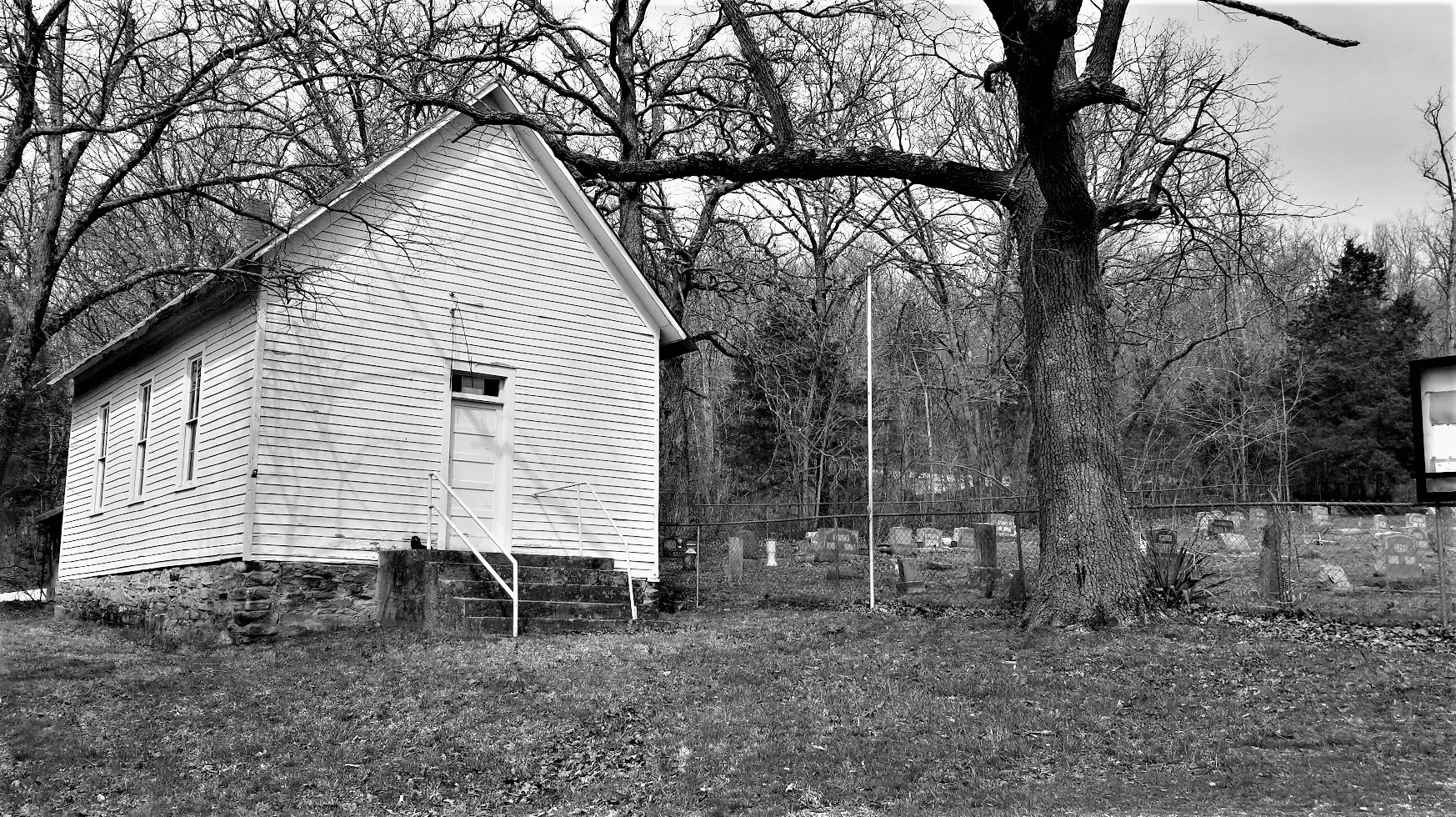
In her second year in High School, Bonnie met Roy Thornton. The couple dropped out of school and married on September 25, 1926, six days before her 16th birthday. Their marriage was marred by his frequent absences and brushes with the law and proved to be short lived. They never divorced, but their paths never crossed again after January 1929. After she left Thornton, Bonnie moved back in with her mother and worked as a waitress in Dallas. Bonnie briefly kept a diary early in 1929 when she was aged 18, writing of her loneliness, her impatience with life in Dallas, and her love of photography. Bonnie was still wearing the wedding ring Thornton had given her when she died. This is a photo of Bonnie's elementary school which still stands today.


Eagle Ford School

Clyde met 19-year-old Bonnie through a mutual friend in January 1930, and they spent much time together during the following weeks. Their romance was interrupted when Clyde was arrested and convicted of auto theft and was sent to Eastham Prison Farm in April 1930 at the age of 21. He escaped from the prison farm shortly after his incarceration using a weapon Bonnie smuggled to him. He was recaptured shortly after and sent back to prison.

Clyde committed his first murder in prison of another inmate, with a pipe crushing his skull, in retaliation for repeatedly sexually assaulting him. Another inmate who was already serving a life sentence claimed responsibility. In order to avoid hard labor in the fields, Clyde purposely had two of his toes amputated in late January 1932, either by another inmate or by himself. Because of this he walked with a limp for the rest of his life. What he didn't know however, his mother had already successfully petitioned for his release and he was set free six days after his intentional injury. He was paroled from Eastham on February 2, 1932, now a hardened and bitter criminal. His sister, Marie said, "Something awful sure must have happened to him in prison because he wasn't the same person when he got out."

On January 6, 1933, officers were staking out this house owned by Lilly McBride, sister of one of the Barrow Gang members. A shootout occurred around midnight and Clyde killed 52-year-old Tarrant County Deputy Sheriff Malcom S. Davis beside the front porch.


Now surrounded by a golf course, this is the Eagle Ford Road Bridge. Back in 1933, this area was known as the "Devil's Back Porch." This once isolated area of West Dallas was rarely policed and is where Bonnie and Clyde often were hiding out in their stolen cars. It was also a gathering place for their family and friends to come and visit with the wanted outlaws.


In May of 1934, a posse of six officers from Texas and Louisiana had followed the trail of Bonnie and Clyde to the Bienville Parish. The setup an ambush along Louisiana State Highway 154 south of Gibsland. At approximately 9:15 am on the morning of May 23rd, the couple came speeding down the road in a Ford Deluxe V-8 Sedan, Clyde's preferred stolen car of choice. The officers immediately opened fire and began unloading about 130 rounds towards the car. In the end, there where 112 bullet holes in the vehicle. Seventeen rounds found their way into Clyde's body and 26 into Bonnie.

The Belo Mansion was built in the 1890's by Colonel A. H. Belo, founder of the Dallas Morning News. The mansion was later leased to funeral home operators George Loudermilk and Will Sparkman. The body of Clyde Barrow's bullet riddled body was laid out in the parlor for public viewing. Approximately 20,000 people came from all over to file past and get a glimpse of this notorious outlaw's remains. Today, this building is the current home of the Dallas Bar Association and Law Review.


Even though it was Bonnie and Clyde's wish to be buried together, the Parker family refused. Clyde Barrow's funeral was at sunset on May 25th at the Western Heights Cemetery next to his brother Marvin where they share a single headstone. There's a geocache hidden nearby (GC7K52N).


Bonnie Parker was laid to rest the following day on the 26th in the Fishtrap Cemetery. Her body was later moved in 1945 to the new Crown Hill Cemetery in Dallas where you can also find another geocache (GC596A).


So that was our quick historical tour around Dallas, Texas and Bonnie & Clyde's stomping grounds and final resting place. One of these days when passing through Primm, Nevada, we'll have to stop by Whiskey Pete's Hotel and Casino to see the bullet riddled Ford Deluxe V-8 there on display.

To follow along on our travels and keep up with my latest blogs, you may do so here of course by clicking the "Follow" button to the right. And there's also my main website at AwayWeGo.US for the complete index of my traveling adventures going back to 2005. But also by using one or more of your favorite of these social media platforms: FacebookMeWeGabRedditTwitterGETTRInstagram, and TruthSocial. These all link directly to my profiles. Again, please feel free to comment and / or share.

Friday, April 7, 2023

2021-03-31: Exploring the Historic Route 66 Through Missouri on Day 9 of Our 3400 Mile Roadtrip Adventure

Winding down on Day 9 of our crazy 3400 mile geocaching and sightseeing roadtrip adventure through history, we spent the day in Missouri trying to follow the original sections of the famous Route 66 highway from St Louis to Joplin. Along the way we stopped at many of the roadside attractions that Route 66 is famous for: a super-sized rocking chair, historic gas stations, old abandoned bridges and more. Oh and let's not forget picking up new geocaching counties along the way too! So hop on board the GeoJeep and let's go for a drive...


Our first two county cache stops was in Crawford County. A travel bug hotel geocache (GCKC79) next to the Crawford County Historical Marker.

Continuing westbound on Old Route 66, we enter the town of Cuba, MO. There we spot several places that look interesting. Among them were the Missouri Hick BBQ with an old garage out building to the side. Or perhaps it was the smoker shack where they slow cooked their BBQ. Don't know but it looked pretty cool.


Next door to it is the Wagon Wheel Motel. Now listed on the National Register of Historic Places, it was built in 1935 and originally called the Wagon Wheel Cabins, Cafe, and Station. Standard Oil leased the station for one year after WWII. The cabin rooms have been upgraded and modernized while still maintaining the exterior historic charm.


A couple of other noteworthy places to stop for a photo in Cuba would be the Holy Cross Catholic Church and the Crawford County Historical Museum, both made of the same stone walls as the motel.

Just a few minutes further in the town of Fanning is our next geocache (GC1G43E). The Rockin' on Route 66 cache brings you to the Fanning US 66 Outpost and the World Famous Rocker seen at the top of this blog post. After a few photos and finding the geocache, we started to drive off.

At the same time I took a drink from my McD's iced coffee I just purchased a few miles back in Cuba. I think I only got 3 or for sips from it as it was more ICE than coffee! So I looped right around and parked back by the Outpost. We went inside to see if they had some bottled Starbucks or Dunkin coffee to pour into my cup. Yep! We ended up spending much more as we walked out with the coffee, a few novelty soda's and some homemade fudge. The proprietor was also very friendly and welcoming. I highly recommend that you be sure to take a look around inside the Outpost as well after getting your required Rocking Chair photo.


While staying on the Old Route 66 can be very interesting, it is also a slower pace and very time consuming. We still have to get to Texas for the next project before too long. Since I already had a geocache found in the next county, Phelps, I jumped back onto the parallel I-44 to quickly put some miles behind us.

Exiting back off into Pulaski County, we make a stop for our next geocache and our first ghost town in a while. "A Gathering of Hookers" geocache (GC174AZ) brings you to the only remnants of the small community that was once called Hooker, MO. Built in 1900, this church building and cemetery are the only evidence of the early pioneers. The slow curving Old Route 66 (1926-43 alignment) passed by right in front of the church. When the new and improved 4-lane US-66 was built (1943-77 alignment), it was straightened and by-passed many of these communities.


A few Route 66 curves later and we arrive at the Devil's Elbow. A small lumberjack settlement began here after the Civil War around 1870. The name derived from a tight U-shaped bend in the Big Piney River. When the lumberjacks would send their logs downstream, they often got jammed up in "a devil of an elbow," which became known as Devil's Elbow.

Also here at the Devil's Elbow are my next three geocaches (GC175JD, GC1TG2P, GC17E9W). I'm just gonna give you a brief description of my two photos below before telling you about a great web page to go look at for more. This bridge was actually built in 1923 as part of the MO-14 state road connecting the communities. Three years later it became part of the original Route 66 alignment. However with the 4-lane realignment of Route 66 in 1943, came a new bridge. This was used only for local traffic and without regular maintenance, it was eventually condemned. Route 66 enthusiasts saved, restored it in 2013, and now open for vehicular traffic once again.


Following the curve around a half-mile to higher ground you get a good look at a section of the Big Piney River where the double truss railroad bridge crosses over.


Now for more historical information and lots of old and new, before and after photos, if you really get into history like I do, take a look at this web page I found on the Devil's Elbow community. It's a quick read and along with the photos and map will give you a better understanding of the Route 66 alignments. As well as some of the businesses that came and gone, and a revealing photo of the 2017 flood.

Making my way further westbound, we arrive in the town of Waynesville, still in Pulaski County, and our next two geocaches. The "Wire Road Stop" virtual geocache (GCE7E0) brings you to an old Stagecoach Stop listed on the National Register of Historic Places. Originally built as a complex with two log cabins in the 1850's, it was later rebuilt with wood in the antebellum style. A stagecoach stop for the Burden and Woodson Stage, also a tavern, used as a hospital during the Civil War, and a hotel after the war. Later abandoned and rundown it had been condemned by the city in 1982. Local citizens got together and saved the historical building. It is now the Old Stagecoach Stop Museum.


The other geocache was at the Talbot House (GC46FPX). One of Waynesville's oldest homes, it was constructed in 1885 by the Rev Albert Washington Davis. Dr. C.A. Talbot purchased the home in 1915 and used it as a residence for his family as well as an office for his medical practice for the next 30 years. After his death in 1945, his widow then rented rooms to boarders. Today, the current owners use it as an Antiques, Collectibles, and Gift Shop business.


Moving on down the road into Laclede County and some more geocaches along the Mother Road. The Gasconade River Bridge (GC8V6TP) is next on the list. I love these old bridges. Like the Devil's Elbow Bridge, this bridge was built during the construction of Missouri's State Highway 14 a few years before Route 66. And again with the new expanded 4-lane Route 66, the lack of maintenance and repairs led to the closure and condemnation by the state in 2014. The Route 66 enthusiasts are trying to rescue and restore this bridge as well.


My next two geocaches are in Lebanon, MO. A quick stop and find for the Graffiti Tunnel (GC8AVN3).


The other geocache has over 500 favorite points and is the second largest cache that I've ever found, with the old Space Coast Geocaching Store cache in Florida being the largest. This one is called Jolly Green Giant (GC1MDCE) and is Missouri's largest ammo can.


There was just one more geocache we stopped for right before leaving the county. Nothing really to see here. But it was a Challenge cache (GC41F8V) that required you to have found a cache in at least 25 states before claiming the find. Well we've found one in 49 states, so I figured I'd stop quickly and sign the log sheet.

Another chance to make up some time as we already have Webster County, I jumped onto I-44 over to Greene County. There were two geocaches (GC2ZFAA, GC2Z72F) near the intersection of I-44 and US-65 that had some favorite points because of their creativity. They were easy to get to and easy to find. Had an interesting containers. What I liked most and wasn't even mentioned on the geocaching listing, was the historical pioneer cemetery just down the short trail.

It was the Union Campground Cemetery which was established in 1840 by the Presbyterian Church for open air camp meetings. Historical research by locals and decedents put the number of burials at around 200. However, documentation has only confirmed 84 burials.


Staying on the Interstate to get through Springfield, I took the first exit into Lawrence County to once again pick up the Old Route 66. Knowing that Route 66 was being built to the west following the old stagecoach trail, Sydney Casey purchased some property in 1925 in the small community of Spencer near Johnson Creek. There he built his businesses in a row of connected buildings, kinda like a mini shopping center. There was a gas station / garage, barber shop, cafe, and grocery store.


Strategically placed on the right just past the Johnson Creek Bridge (GC7TE1D) which was built two years earlier, Casey was open for business from the Route 66 travelers crossing the bridge. Looking west through the bridge, you can just make out his shops on the right past the Jeep. Then another 1/4 mile beyond and further up the hill was the Camp Lookout Cabins for the weary travelers looking for a break from the road.


The businesses prospered until the new Route 66 alignment a couple miles to the north bypassed this section of the original roadway in 1960. Then eventually killed any thru traffic with the construction of Interstate-44. The cabins no longer exist except for a couple of the foundations can be seen in the grass. Fortunately with the historical interest and fans of Route 66, what does remain here in Spencer has been rescued and slowly restored. Along with the geocache on the bridge, there are 4 easy multi-caches going up the hill using clues gathered from the shops (GC7RPV0, GC7RPY7, GC7RPZ0, GC7RQ04).

Passing through west into the community of Phelps, I spotted this old school building. The Phelps School was a one-room school built in 1888. Classes were held there until 1952. It was later abandoned and fell into disrepair in the 1980's. Eventually the community got together and restored it.


Entering into Jasper County and approaching the town of Carthage, we arrive at our next geocache. The Jalopy (GC4QMA6) is another example of artist Lowell Davis creations, an old car driven by a hillbilly and his hound dog.


Well that's our quick tour of Route 66 through Missouri. One day in the future, probably after retirement, we'll get to take a slower and complete roadtrip stopping in all the small communities. But it's late now and we made it to Joplin. Believe it or not we found a great Greek restaurant called Mythos. Time for a bite to eat and then get some sleep! She got the grilled chicken salad and I got the sampler platter.


To follow along on our travels and keep up with my latest blogs, you may do so here of course by clicking the "Follow" button to the right. But also by using one or more of your favorite of these social media platforms: FacebookMeWeGabRedditParlorTwitterGETTRInstagram, and TruthSocial. These all link directly to my profiles. Again, please feel free to comment and / or share.

Friday, December 30, 2022

2021-03-28: Visiting Presidents Lincoln and Reagan in Illinois on Day 6 of Turning a 1400 Mile Road Trip into a 3404 Mile Adventure!

Welcome back friends, family, RV'ers, Geocachers, Jeepers, and fellow travelers of the open roads. In this edition of our AwayWeGo Adventures blog, we pick up where we left off yesterday at the state line entering Illinois from Indiana. We spent the whole day in Illinois as we grabbed new geocaching counties and picked up some Presidents Lincoln and Reagan historical sites. And a really cool college ghost campus along the way! There's no debate about it, we've got lots to show you. So join us as we do some sightseeing along Illinois backroads...


So yesterdays blog focused on the General Lew Wallace Study / Museum and the Ben-Hur story. We did continue on and cross the state line that afternoon, but I wanted to hold those geocaching stops into todays Illinois post.

A geocache needed in Vermillion County was our next stop. Driving westbound on I-74 past Danville, is the Salt Kettle Rest Area. While many may stop for a much needed break at the rest area, few realize that there is a pioneer cemetery (GC35GC9) just a short hike along a trail to the east.

Edward M. Wilson was born 1785 in Ireland and immigrated to the United States in 1802 at age 17. He served in the Battle of North Point, in Baltimore, MD, which occurred on Sept. 12, 1812 and the following 2 days, the Battle of Baltimore at Fort Henry occurred. During this battle and bombardment on Fort Henry, Francis Scott Key penned the words to The Star-Spangled Banner. In 1832, Edward migrated west, married Caroline Searl on June 29, 1835 (she was born Feb. 23, 1811 in Mass.) and she died April 14, 1867 and is buried next to him here in Searl Cemetery. Edward died Sept. 4, 1840 age 55. Edward bought property in Vermilion County in 1832 and before he died, he amassed quite a bit of property which included this family cemetery.


Moving west along I-74 into Champaign County, the was another cemetery right near the exit. That made for a quick geocaching find for the county (GC2739Z).

Passing through the northeast corner of Piatt County, there was a quick park and grab geocache (GC6CA0A) right at the exit that allowed us to continue moving and putting miles behind us. And the same thing just a few miles further in DeWitt County (GC3X0ZC). I already had McLean County from my truck driving days back in 2008, so we turned north on I-39 in Bloomington to Woodford County. There we grabbed a quick roadside cemetery cache near the small town of El Paso (GC971CA), didn't know there was an El Paso in Illinois.

Continuing north into Marshall County, there was an earthcache (GC1BRDJ) I decided to stop for. An earthcache is a geocache without a traditional container and logsheet. To get credit for the cache, you are to observe something geological there and answer the specified questions within the description on the cache page. At this location in the middle of vast farmland is this huge boulder sitting where it's difficult to find even the smallest of rocks. Supposedly this was carried down to this location on ancient glaciers and left here when they melted.


Making good time and now up in LaSalle County, we stopped for a quick geocache (GC473T0), some fuel, and some food. Then a quick geocache (GC17KM8) stop at the Willow Creek Northbound Rest Area.

Then we took the Lincoln Highway east over into DeKalb County for two cemetery geocaches (GC7PRVY, GC8D9GA).


Back to I-39 northbound, we stopped for a quick roadside geocache (GC39RYA) near the exit in Ogle County. But it was missing and we had to DNF it. So I looked up another nearby cemetery geocache (GC4GVX3) that was a little further out and found that one to get credit for the county.

So that finished up Day 5 from yesterday. Today we began in Rockford, IL. Now the original plan for our extended roadtrip going from North Carolina to Texas via the LONGWAY across the northern states, had us jumping up into Wisconsin and Minnesota also. But this morning we were met with an artic blast of temps in the low 30's and an expected high of only 45 degrees! And that was for Rockford. Why would we even want to go further north?? Change of plans...

After some coffee and breakfast, we grabbed a quick parking lot geocache (GC28T0P) for Winnebago County.

Because of the artic blast, I head west on I-90 instead of north. The next stop was a geocache (GC5WQ5A) in Stephenson County. It was outside the old Lincoln School building. The front of the building says Lincoln School. On one side above the door it says Boys Entrance. On the other side it says Girls Entrance. I don't think it's a school anymore. Other than that, an hour of searching the web and I can't find any history on the building.


A few blocks away was the historical Debate Square. In 1858, the Democratic Party was the majority party in Illinois and Douglas was by far the most popular member of this party. Lincoln was not well known because his party, the newly formed Republicans, were still trying to create an organization. As a result, Lincoln had trouble drawing crowds as he canvassed the state in his bid to unseat Douglas.

Finally Lincoln suggested to Douglas that the two of them share their platform and divide their speaking time. Douglas had nothing to gain by agreeing with Lincoln, but loving a good political brawl, Douglas agreed to Lincoln's proposal.

Photo Bomb!

Seven debates were scheduled in each of the congressional districts in which the two had not already appeared in close proximity. Ottawa, Illinois was the location of the first debate on August 21, 1858. On this square in Freeport was the second debate on August 27, 1858.

On the corner of the Stephenson County Courthouse Square is this Civil War Memorial honoring those citizens of this county who gave their lives during the war.


One more county in the northwest corner of the state and we take the very backroads to get to the nearest two geocaches. The first was along a heavily wooded area on the north side of the Ward's Grove Nature Preserve (GC302PR). The geocache was hidden by the rock wall in the back near the shallow cave-like openings. As thick as this looks now, I'm just glad spring hadn't sprung yet and the whole area covered in foliage!


The second geocache (GC8PA44) in this county was further down a rural country road to view a tree carving on the lawn of a farm house. This is a carving of Chief Black Hawk, between this site and the Black Hawk Monument at Kellogg’s Grove is where the skirmish of 1832 took place. Makataimeshekiakiak (“Black Sparrow Hawk”) was known to European-Americans as Black Hawk. Born around 1767 in the village of Saukenuk, he grew up very anti-American supporting the British during the war of 1812. Commonly referred to as “Chief,” he has no official position in his tribe. He did, possess, however, natural leadership skills that caused many warriors to follow him.


Working our way south now towards warmer weather, the next county on the list is Carroll County. I have three geocaches selected here and the first two are in the town of Mount Carroll. The Shimer College Campus (GC8FXG4, GC5FGN9) was originally founded as the Mount Carroll Seminary in 1852 by Francis Shimer. It grew from just 11 students in one room to over 100 students in four main classroom buildings. And it was primarily an all girls school ranging in ages as young as 3 to college students. There were some boys that had attended over the years, but they were only allowed to be day students not living on campus.


In 1896, the school partnered with the University of Chicago and the Baptist Church and became the Francis Shimer Academy. Over the years there were many changes as the college struggled financially and admissions rose and fell. In 1950 the name was changed the Shimer College and it became coeducational school once again. The highest number of students was in the 1960's with just over 500 attending classes. Disagreements with the older more conservative faculty and the younger faculty and students of the late 1960's led to a third of the students and some faculty leaving. Several bankruptcies and school closers later, the yearly student enrollments fell below 100 and around 50 most of the time. In 1979 the school board decided to move classes to the town of Waukegan, Illinois.


During the 1980's, a group of Mount Carroll residents organized the Restoration College Association which later became the Campbell Center for Historic Preservation Studies to prevent the campus from being broken up. As I walked around this campus, the more than a dozen buildings appeared to be abandoned. I kept thinking to myself that these would be cool to own, restore and turn them into something useful. Well that is currently the intent. It is now call Shimer Square and more than $30 Million will be invested over the coming years to convert building to housing, business, and community amenities. You can read about the future plans and progress here.

OK, back to geocaching. From there we drove over to State Road 84 which follows along the banks of the Mississippi River, stopping for a quick cemetery cache in the town of Ayers (GC8C16J).


Continuing south into Whiteside County and the town of Fulton, we stopped at Calvary Hill Cemetery for our next geocache (GC39WDR). Resting atop the hill overlooking the great river is a historical headstone of presidential significance. Buried in this cemetery are President Ronald Reagan's paternal Irish ancestors. His great-grandparents, Michael and Catherine Mulcahey Reagan, emigrated in 1856 and after Michael's 1884 burial in Calvary Hill Cemetery, Catherine and three children moved to Fulton. One son, John, married Jennie Cusick. Both died in their thirties and left four orphans. One of those was Jack, whom became the father of the future president. A total of 16 Reagan relatives are buried here.


From there we drove over to the town of Tampico. The geocache (GC90AHG) happen to be missing at the time of our visit so we did have to log a DNF. But we did find some more presidential history. From the historical marker: "On February 6, 1911, Ronald Wilson Reagan was born in an upstairs apartment at 111 South Main Street. His father, John "Jack" Reagan, of Irish-Catholic ancestry, was a clerk in the H.C. Pitney Store also on Main Street, and gave Ronald the nickname "Dutch." His mother, Nelle Wilson Reagan, was of Scots-English background."


"The small town atmosphere of Tampico played an important role in Reagan's formative years. As a child he played on a cannon in the park. Both of Reagan's parents were known for their acting ability in productions at Burden's Opera House on Main Street. Ronald Reagan became a sports announcer, a well-known movie star, served as Governor of California from 1967-1975, and then President of the United States from 1981-1989. He died in 2004 and is buried at the Regan Presidential Library in Simi Valley, California."


Unfortunately the Reagan Birthplace Museum was closed while we were here and we didn't get a chance to take the tour.

Now back over to the banks of the Mississippi River, we entered Rock Island County and the town of Rapids City. There we made a quick roadside geocache (GC33PJR) find for the county.

Being so close, we took the I-80 bridge across the river into Iowa to check off a bucket list item. The American Pickers is a popular TV show and they happened to be based right there Le Claire, Iowa, just outside of Davenport. There's also a geocache hidden there too (GC3MYET)! Well, we found the geocache but arrived just as two girls were locking the doors to leave. I didn't recognize either from the show, so no autographs.


Jumping onto I-74 eastbound, which in reality goes straight south through three counties, we stop at the rest area in Henry County for another quick geocaching find to claim the county (GC2BVRR).

Our jump over into Iowa for the cache at the Antique Archeologists put us back on track with our original planned route if we had gone up into Wisconsin, Minnesota and then down into Iowa. We would have then crossed back into Illinois to where we are now.

That's it for a long day today. Join us again next time for Day 7 as we continue finding more President Lincoln history and make our way over to the Historic Route 66.

To follow along on our travels and keep up with my latest blogs, you may do so here of course by clicking the "Follow" button to the right. But also by using one or more of your favorite of these social media platforms: FacebookMeWeGabRedditParlorTwitterRVillageGETTRInstagram, and TruthSocial. These all link directly to my profiles. Again, please feel free to comment and / or share.

Friday, December 23, 2022

2021-03-27: Visiting the Birthplace of Ben Hur on Day 5 of Turning a 1400 Mile Road Trip into a 3404 Mile Adventure!

Today was a special geocaching roadtrip day. While I've never heard the name of General Lew Wallace before, I'm VERY familiar with his work. Or more specifically a 1959 interpretation of his work. In 1880 Lew Wallace's second book, "Ben-Hur: A Tale of the Christ", was published. Today we got to visit General Lew Wallace's Study and Library. So come aboard and join us on Day #5 of our 3404 mile road trip adventure. Today's journey has us finishing up Indiana and into Illinois. Are you in? Let's go for a drive...


We started out the day in Crawfordsville, Indiana in Montgomery County. The first stop was downtown for a virtual geocache (GCHXCT). The Montgomery County rotary jail and sheriff's residence was built in 1882. The first rotary jail built in the United States constructed based on plans based on patented design of William H. Brown and Benjamin F. Haugh of Indianapolis. Used as a jail until 1973 and opened as a museum and restoration begun in 1975. It was also listed in the National Register of Historic Places in 1975.

The circular cell block has sixteen wedge-shaped cells on a two-story turntable around a central shaft. The design promised better prisoner security and jailer safety. The cell block was immobilized in the 1930's as a hazard to prisoners. County jails were first established in 1792 under laws of Northwest Territory; continued under laws of Indiana Territory and state constitutions of 1816 and 1851.


We then drove over to the homesite of Lew Wallace. It was still a little early and the grounds and museum wasn't open yet. So the next three geocaches were located just outside the northwest side of town in the Oak Hill Cemetery (GC2JHCJ, GCVTJ8, GC2GGZB). Formed on April 12, 1875, the Oak Hill Cemetery Company purchased 100 acres and the cemetery was dedicated on October 20th. Today the cemetery hosts over 14,000 interments.

Among the many notable permanent residents here, like Civil War officers, Congressmen, a Governor, and others, is General Lew Wallace and his wife Susan Arnold Wallace. This is the monument for the Wallace burials. Let me first tell you about Susan Wallace.

Susan Arnold Elston was born on Christmas Day in 1830. She was an accomplished author who wrote travel articles for several magazines and newspapers across the country. Susan married Lew Wallace in 1852. She also wrote six books that were published in her lifetime: "The Storied Sea" (1883), "Ginevra" (1887), "The Land of the Pueblos" (1888), "The Repose in Egypt" (1888), "Along the Bosphorus and Other Sketches" (1898), and "The City of the King" (1903). Before her death in 1907, Susan completed Lew Wallace's 2-volume autobiography which he started before his death in 1905.


Now back at the General Lew Wallace Study and Museum (GC1EQWB), these are the north grounds of the Wallace estate. Lew and Susan Wallace built their modest Victorian home on Elston Family land in 1868. The house was sold to outside the Wallace family in 1919. A brick wall was then built by Lew's son Henry to separate the two properties. The main house is still private property and not a part of the museum.

Upon entering the grounds, you'll first encounter the Carriage House which is now the museum office. The Wallace's built the carriage house by 1875. It contained a stall for Lew's horse, "Old John", a carriage room, a hay loft, and a workshop where Lew worked on his inventions. The house was first remodeled in 1946 and used by the girl scouts. The exterior was restored in 2006 retaining its Queen Ann elements from the 1800's. The interior was adapted to be used for the museum office, gift shop, exhibit room, kitchen and storage. The Wallace's original unrestored carriage (seen below) is located in the basement of the study.


Copied from the informative sign on the grounds: The Ben-Hur Beech Tree and Statue of Lew Wallace. "Its spreading branches droop to the ground... and under them I am shut in as by the walls of a towering green tent. How often while lending me its protection and fragrant coolness, it has been the sole witness of my struggle to whip an obstinate thought into comeliness of expression; and how often out of respect for me it has maintained a dignified silence when it might have laughed at my discomfiture." -- Lew Wallace, about his beloved tree.

Lew Wallace wrote much of his famous novel, Ben-Hur, under this huge tree which came to be known as the Ben-Hur Beech. Because he loved the outdoors, Lew often brought a favorite rocking chair and lap desk outside to work. The tree was struck by lightning in 1907 and taken down in 1908.

In 1910, the Indiana State Legislature honored Lew by placing a statue of him in Statuary Hall in Washington, D.C. Lew's son Henry was so impressed with sculptor Andrew O'Conner's work, that he ordered this bronze copy and placed it where the Ben-Hur Beech Tree once stood.


Now for the main attraction. In 1879, Lew had written to his wife Susan: "I want a study, a pleasure-house for my soul, where no one could hear me make speeches to myself, and play the violin at midnight if I chose. A detached room away from the world and its worries. A place for my old age to rest in and grow reminiscent, fighting the battles of youth over again."

Construction of his "pleasure-house," known today as the Lew Wallace Study, began in 1895. It was designed by Wallace himself and combines elements of the Greek, Roman, and Byzantine architecture that he saw in his travels. Lew Wallace enjoyed his refuge for the last ten years of his life.


Stepping inside the study was like stepping inside the mind of Lew Wallace. In his public life, Lew was a lawyer, a soldier, Union General during the Civil War, Governor of the New Mexico Territory, U.S. Ambassador to the Ottoman Empire, and author. As well as writing, he also enjoyed painting, fishing, music, reading, inventing, and the outdoors.

The first thing that caught my eye is what I was most interested in, the Ben-Hur display! The short sword was used in both the 1925 and 1959 movie. The wrist band was worn by Francis X. Bushman (Messala) in the 1925 movie. The album is a souvenir from the Broadway Play. The photo just to the left of the red Ben-Hur spice cans is of Charlton Heston while visiting the Lew Wallace Study in 1993.

The book is a "first edition, binding state 1" of Ben-Hur. This first edition was approximately 2,500 copies and featured a floral pattern on blue-gray cloth. Susan Wallace objected to the cover, so subsequent bindings of the first edition were brown mesh cloth (binding 2) and brown pebbled cloth (binding 3). While all these are considered first editions, the floral binding was the initial cover and the rarest. If you ever see one of those at a garage sale... BUY IT QUICKLY!!


Standing tall next to that display case was the complete suit, robe, sword and armor worn by Charlton Heston in the 1959 movie.


Lew Wallace had an extensive collection of books in his study. This is just a section of those shelves that practically wrapped around the entire room. Ben-Hur had been translated into more than twenty languages and there's a least one copy of each on the shelf. He also has a large selection of bibles and study guides. His portrait is at the top left in the photo below as well of the smaller photograph in the bottom right corner.


Not only did Lew own and play some of the finest violins of his day, but he also learned the craft of building his own violins as well.


Painting was another of his hobbies. Much of the artwork hanging in the study was painted by him. This was his watercolor set along with a small sketch and a finished painting.


Fishing and inventing were a couple more of his many interests. The silver piece at the bottom of the next photo combined both of those. An invention of his that spooled the fishing line inside the pole, not externally.


The last thing I want to show you is the large skylight in the center of the study. You can get a good look at it from the outside in the photo at the top of the page. This skylight actually has a crank on the corner which Lew Wallace used to open and close it allowing for a cool breeze to circulate on the warm summer days.


There is much more to be seen here at the General Lew Wallace Study and Museum. But I'll just leave that up to you to go and visit this historic place in Crawfordsville, Indiana, just northwest of Indianapolis. We spent a few hours here.

A great example of what I like about geocaching. Driving from point A to point B like I used to and I would have just passed these places all the time. Now because of geocaching, I look for the places to see and stop along the backroads.

A few more geocaches in Indiana to pick up Fountain, Warren, and Vermillion Counties before moving into Illinois. We did grab some geocaches in Illinois today also, but I decided to tell you about those in the next blog with the other Illinois caches. I wanted to focus on the Lew Wallace story in this one. So, see you back again real soon.

To follow along on our travels and keep up with my latest blogs, you may do so here of course by clicking the "Follow" button to the right. But also by using one or more of your favorite of these social media platforms: FacebookMeWeGabRedditParlorTwitterRVillageGETTRInstagram, and TruthSocial. These all link directly to my profiles. Again, please feel free to comment and / or share.