Hello again and welcome back to another one of our Geocaching adventures. After last weeks exhausting hike up Guadalupe Peak, today was supposed to be one of those driving from cache to cache days. However, one of Candy's co-workers heard about our hike and saw the photos and she wanted to go hiking with us. She is also in the Marine Reserves and was leaving soon, so a change of plans and back to the Guadalupe Mountains National Park.
This time we decided on hiking through the McKittrick Canyon trail. That trail had an earthcache (GC1WAPB) near the trailhead and visitors center, as well as two virtual Geocaches out on the trail. When we arrived at this visitors center, a few miles east of last weeks visitor center for the peak trail, we found that the restrooms were out of order. So we drove back to the main road and the nearby rest area. While there, we found the two quick LPC Geocaches also.
 Now back at the visitors center, we gathered our backpacks and headed onto the trail. It was a little bit later a start than last week as it was now close to noon. I also came prepared this time for the "day use fee" and did not have to search for loose change.
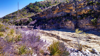
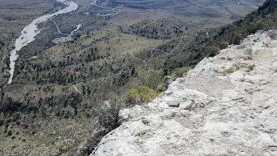
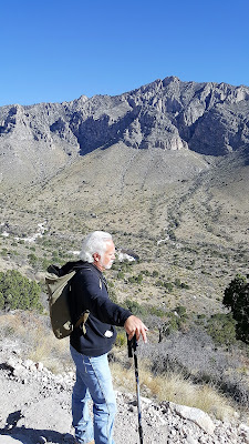
This hike was definitely easier than last week being mostly flat in the beginning. The McKittrick Canyon trail follows along the mostly dry stream bed, crossing through it several times as the trail and stream wind through the canyon. It was another clear blue sky day which made for some excellent views of the mountains on both sides of our hike. I'll let you enjoy a few pictures before I continue writing.
The next few pictures show the dry stream bed. For the first mile or so, there isn't any water flowing at all. From the looks of the erosion and the smoothness of some of the rock, it appears as though they get a whole lot of water flowing through here at times. But since we've been to West Texas, it hasn't rained that much.
 After about a mile and a half down the trail we began to see a small clear stream flowing within the bed. It had a pretty decent flow rate going so it was a little puzzling. It seemed as though it may have been coming from a spring and then disappearing into the rock again. The way the trail weaved in and out, we never did see the beginning or the end of the water flow to know from where it came or where it went to. I figured on the way back, maybe we'll follow the stream bed instead of the trail to see how and where it originated.
About this time we encountered the park ranger hiking up the trail. I slowed a bit to let him catch up to me while the girls continued their pace. After a few minutes I asked him about the stream. He didn't really say it was a spring, but just that it began and ended.
 He told me the story that the once land owner, Wallace Pratt (I'll get to him shortly), said the stream flowed constantly back in the 1920's and 30's through the canyon until it exited into the desert and dried up. Then in the late 30's and early 40's there were two floods. Mr. Pratt said that after the second flood, the stream just sank into the ground. And from then on it just flows on a few segments for a short distance.
So I still don't know how it originates or where it ends. But we will have to return again for another hike. Maybe we'll follow the stream bed then to find out.
So now for the next half mile or so, we're still hiking along with the park ranger and I notice on my GPS that we're getting closer to our first virtual Geocache (GC3A26). At about 300' away from the cache pointing to the right, the park ranger also says he has arrived at his destination. It seems we were going to the same place. Although he didn't know anything about Geocaching because I was explaining it to him along the way and that it was the main reason that had us hiking this trail.
 We left the trail at these two stone pillars which led up to this old stone. The Wallace Pratt Lodge was the summer residence of Wallace Pratt (1885-1981), the principal donor of the lands that would become Guadalupe Mountains National Park. Pratt was a petroleum geologist employed by the Humble Oil Company, scouting for oilfield leases in west Texas. Pratt visited the Guadalupe Mountains in 1921, and taking a liking to the place, he bought a quarter share of the McCombs Ranch. There was at one time a road that led down into the canyon to the house. But the park service had it torn up and removed long ago.
 In 1929 Pratt bought out his partners, ending up owning a large portion of the canyon, which featured waterfalls flowing over travertine dams, a lush, quiet place in the high desert. In the winter of 1931-1932 Pratt started construction of a house in the canyon, designed by Houston architect Joseph Staub. The cabin was built by Staub's former employee Vance Phenix and Vance's brother Dean, a carpenter, with stonemason Adolph May. The cabin was built of local limestone and heart pine. There was even a separate two car garage for their "his and hers" Mecedes-Benz's.The Pratt family spent summers at the cabin, which they called the Stone Cabin, and briefly lived at the cabin during Wallace Pratt's early retirement, while they built their final retirement home, the Ship On The Desert, outside of the canyon. The cabin accommodated the Ship on the Desert's architect during its construction. After the family moved to Tucson, Arizona, they donated the cabin, new house and surrounding lands of more than 5,000 acres (2,000 ha) to the National Park Service, the nucleus of Guadalupe Mountains National Park. The cabin was listed on the National Register of Historic Places on March 26, 1975.
So after touring through the old house, we thanked him and continued further up the trail. Now here's where it gets really interesting...
About another mile down the trail we catch up to another couple who left the Pratt House just before us. They were at a fork in the trail. There was a sign there pointing to the "Grotto" to the left and continuing the McKittrick Trail to the right. They asked us if we had been on the trail before, but this was the first time for us all. They were looking for the trail that took them to higher elevation to view the canyon. We wanted the correct trail that led to the virtual cache! They remembered something the park ranger had told them about the Grotto, but didn't remember if that meant to follow that trail. Our GPS was leaning 3.4 miles slightly right. But that doesn't mean much winding around through the mountains. So they went left and we went right.
About a 100' further and we began climbing. Now up to this point and for the last 3 miles to the visitors center, we ONLY had a 200' elevation increase! Now we were starting to climb. I think this was the way the other couple needed to go also.
Even though the elevation was increasing more dramatically, it was still a fairly easy trail for a moderate rating. Then we encounter the rocks!!! The trail went from a smooth incline to an extremely rocky, big boulder steep incline! This was more like rock climbing than a hiking trail. Even the severe rated trail for the peak wasn't this rough. But we're adventurers, so we continue on. Perhaps it's just a short rough section that gets back to normal just around the next boulder. And according to the GPS, we're still heading in the right direction.
Continuing to climb, up another 100', then another 100', just when you think that if you climb over this spot and around that corner, there we'd find the normal trail again. Somewhere around the 400'-500' mark, it looked like a split so I quickly went ahead to the left to see if there was a way through. Nope that was a dead end. So I yelled back to have them head the other way.
I went ahead quickly up that side as well and saw no end in sight. It was just more large rocks and steep climbing. Finally I suggested we call it quits and head back down. It looked like we were getting closer to the top, but I'd hate to have climbed another 200'-300' only to encounter and dead end cliff wall.
So we all agreed and headed back down the rocks. Finally we get back down to the normal looking trail when suddenly there's a fork in the trail. WHAT? We don't remember that! Where did THAT come from? I zoom in on the GPS and noticed that we had came from the left. NO WAY!!! The TRAIL actually switched back to continue up the other direction! We didn't even notice that. So in reality, we were NOT climbing up the trail but just a rock wash.
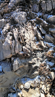
The two pictures above don't do justice, but kinda give you a sample of what we climbed. We didn't take many pictures in that area as we kept our phones in our pockets to keep our hands free for climbing! In the photo below, you see the thick trees at the bottom? Down in there is where we missed the switchback on the trail. Now from there follow the crevice up the left to that large shaded area. That's about where we climbed to before turning back down.
So while we were at the switchback, three hikers came through and we asked if they had been on this trail before. Nope, it was their first time as well on this trail but said they hiked a lot. It showed as they walked fairly quickly. After debating a brief moment, we decided to continue forward on the correct trail to see where if we could make it to the other virtual Geocache, still more than three miles away. But that was a straight line distance, not the actual trail distance.
 We caught up with the three hikers after a couple of switchbacks as they were seated and grabbing a snack. One of them began asking us what our plan was and if we had a car parked at the visitors center. He informed us that the front gate would be locked at 6:00 pm and we should be back at the visitors center by 5:30 in order to make the drive out the gate in time. By now it was 2:30 and there was no way to make it to the virtual cache AND still have time to make it back. So we decided to turn around and head back.
Just about that time, the couple we met by the Pratt House and later at the fork to the Grotto came walking down the trail from further up. They were puzzled at how they had passed us when I explained about our misfortune of making the wrong turn and we hiked up the rocks. They said the Grotto wasn't that far down their trail which they took. After looking at it, they doubled back and followed the trail we took. They however made the switchback and passed us while we were rock climbing.
The walk back was brisk, yet seemed to take forever. Especially that last mile! I kept watch on the GPS and it wouldn't move for long stretches as we rounded the base of a mountain along the trail. It just kept pointing to the mountain as we had to round the base to the other side. Then the compass would point straight and we'd start closing in on the car. But the needle would start to veer off to the side again as we rounded another corner. Our total hiking distance according to the GPS was 9.19 miles.
It was another great Geocaching adventure and a fun hike. Not as sore this time as last week. Even with our wrong turn climbing up the rocks, we still had a good day. Candy's co-worker also enjoyed her day hiking and learning about Geocaching. It's too bad she's being transferred in a couple weeks. Maybe we'll be able to get one more hike in before that.
That's it for now. See you back again next time.


