Saturday, March 11, 2023

2021-03-29: Touring More Abraham Lincoln and Route 66 Sites in Illinois on Day 7 of Turning a 1400 Mile Road Trip into a 3404 Mile Adventure!

So today as we geocached more Illinois counties, we followed more footsteps of President Abraham Lincoln historical sites and jumped onto the Historic Route 66 to continue our southwest roadtrip. There's a LOT to see and do today, so let us go for a drive and get on down the road...


Waking up in Peoria County, Illinois this morning, it was still cold but not like it was yesterday morning. First thing first... breakfast, coffee, and hey look there's a geocache right there in the parking lot (GC42BCA)! Then next door into East Peoria and Tazewell County, we made a quick exit off the highway in this industrial area for a creative geocache (GC24KTM) that had a lot of favorite points. Luckily, truck traffic wasn't that busy. Parked on a side street and a short walk across the grass. Found the container quickly and another minute to figure out log sheet retrieval.


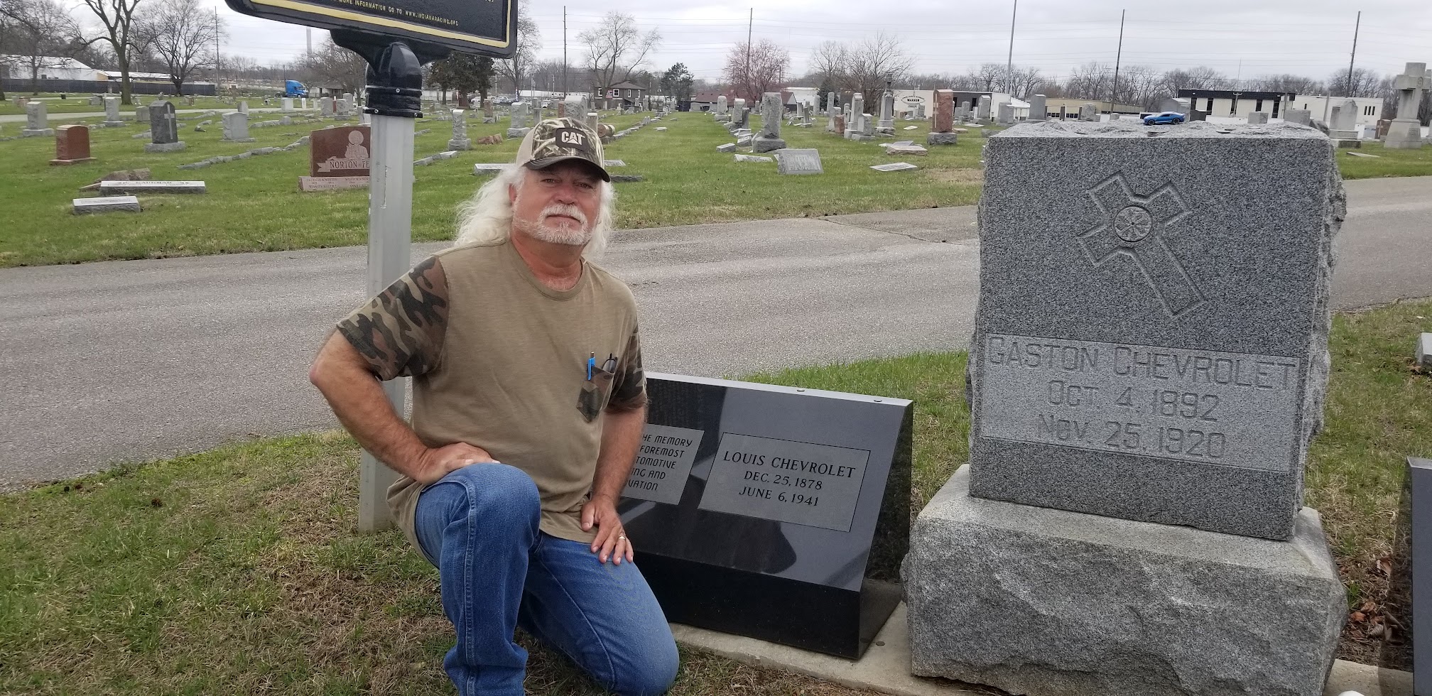
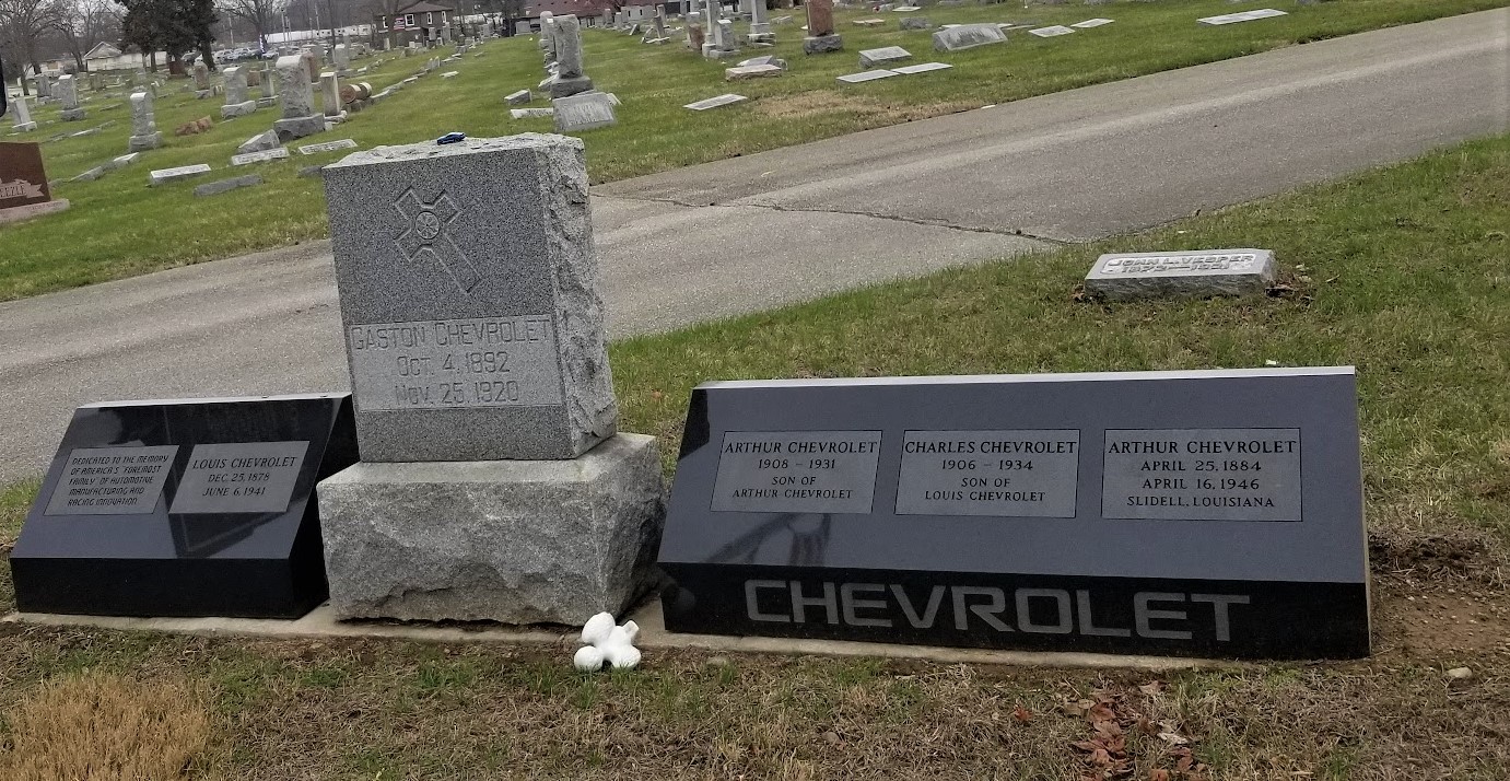
Southbound on I-55 into Logan County, we exit into the small town of Elkhart. A couple of blocks off of the Old Route 66 and near the town square, is this Veterans Memorial Statue honoring those in the community who have served in the various wars.


Just outside the east side of town are my next two geocaches (GC4MYJP, GC8P1YG). The first settler in the Elkhart area was James Latham. In 1824 he was appointed by President John Quincy Adams to the position of Indian Agent at Fort Clark (now Peoria). He moved the family there and in two years took ill and died. They brought him back to the hill and buried him in Latham Cemetery (not far from where his first cabin was built) which has the distinction of being the oldest cemetery in Logan County.

One of the highest points in the state is Elkhart Hill. Abraham Lincoln often stayed in the Kentucky House, a stagecoach stop on Elkhart Hill owned by his friend Richard Latham. He was also a friend of John Dean Gillett, who was once known as the “Cattle King of the World.” Gillett was the primary financier of Lincoln, IL, the Logan County city that bears Abraham Lincoln’s name.

The Elkhart Cemetery is located on the south side of Elkhart Hill. Near Gillett’s grave, is the Saint John's Chapel. It was built in 1890 by the Culver Stone Co. in memory of Gillett. Still owned by the Gillett Farm, it is the only privately owned chapel in Illinois.


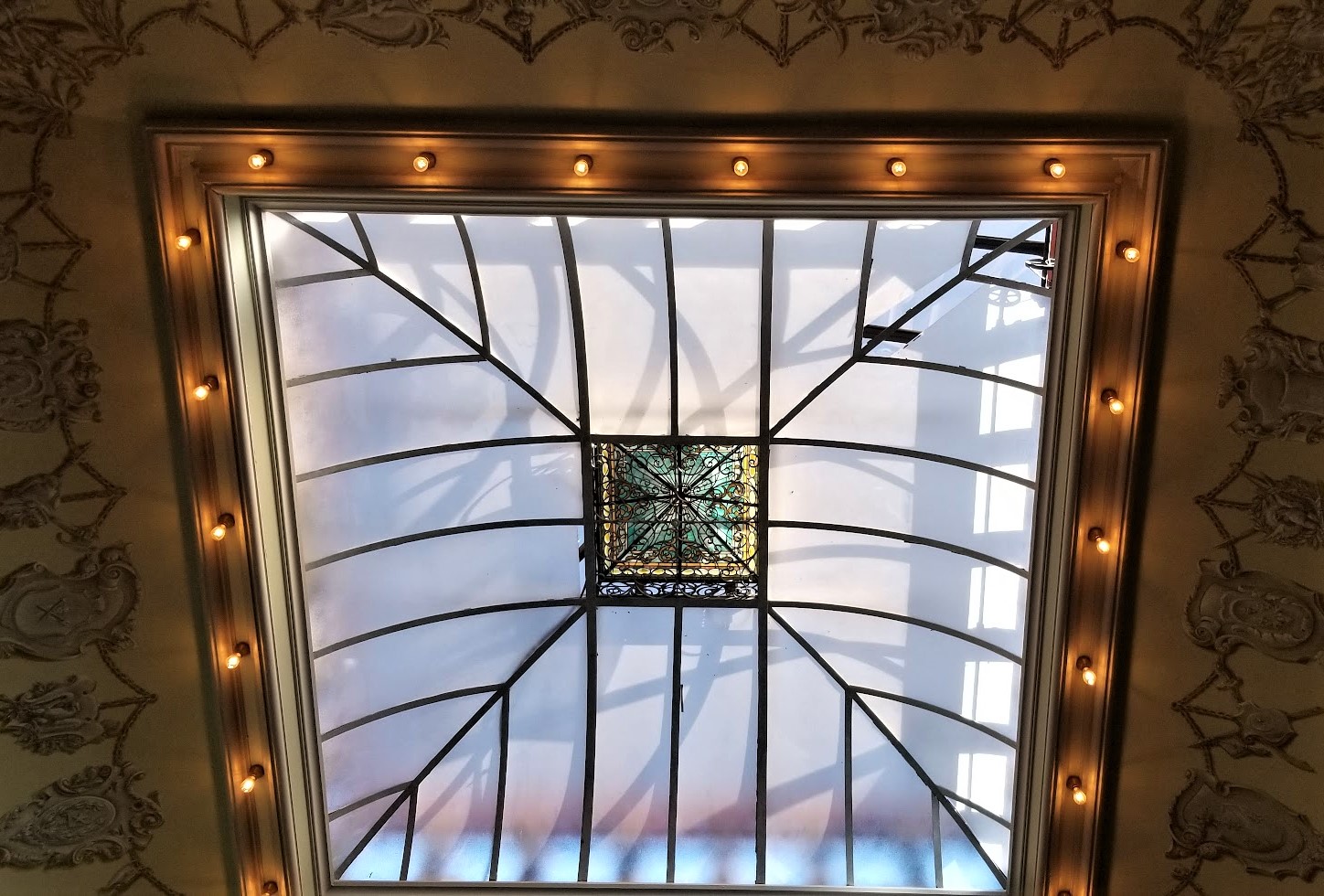
Richard J. Oglesby, three term governor of Illinois and a close friend of Abraham Lincoln, married the Gillett's oldest daughter, Emma. They built their home across the hill from the Gillett house. Known as Oglehurst, the 46 room mansion had a pipe organ in the Great Hall, a fourth floor school room where the children were tutored and a music room with a musical score detailed in the gesso work around the ceiling. The Oglesby's are buried in a tomb on Elkhart Hill.


The cemetery is also the final resting place of Capt. Adam H. Bogardus, who toured with Buffalo Bill Cody’s Wild West Show and was known as the “Wing Shot Champion of the World.”

Connecting Elkhart Hill to Elkhart Cemetery is this bridge which was erected in 1915 by Emma Gillett Oglesby. It is said to be the only private bridge over a public highway in the state. 


This time I decide to stay on Old Route 66 instead of jumping onto the Interstate. Crossing over into Sangamon County and the town of Williamsville, I spot The Old Route 66 Gas Station and Garage. I couldn't buy gas at 31 cents a gallon, but I did drive away with some good photos.


Now moving down the road into Springfield, Illinois. Settling began in 1810 and eventually the town of Springfield became the state capital of Illinois. Abraham Lincoln lived in the Springfield area from 1837 until 1861. In May of 1839, construction began on this cottage for Reverend Charles Dresser. It wasn't until 1844 when Abraham Lincoln moved his family, wife Mary and son Robert, from a rural community on the outskirts and purchased a small cottage house within Springfield. The Lincoln's made multiple renovations and expansions over the next 17 years while they lived in the home. In 1861, now President Abraham Lincoln moved the family to Washington D.C.


Several tenants occupied the house up until Robert Lincoln deeded the house to the state of Illinois in June of 1887. President Nixon established the house as the Lincoln Home National Historic Site in 1971/72 (GC963C).

Pictured below is Abraham Lincoln's "campaign bus" which he used to travel around in while running for office. A big difference compared to today's 45 foot luxury motorcoaches!


Two blocks away from the Lincoln House is Union Square. Union Station opened in 1898 as the passenger terminal for the Illinois Central (IC) Railroad. Francis T. Bacon, an IC architect, designed the station. The current 110-foot-tall clock tower is a reconstruction replacement of the original which was removed in 1946.


Vacated by the railroad in 1971, Union Station was rehabilitated by the Scully family in 1985 for retail use. The State of Illinois leased the building for offices in 1990, eventually purchasing it in 1990. A rehabilitation began in 2005 returning the train station to the turn-of-the-century appearance.

On this public square and in surrounding buildings (GCMNH3), Lincoln and his family and friends purchased goods, attended parties, enjoyed picnics and parades, watched theatricals, and listened to concerts and lectures.


In law offices and courtrooms overlooking this square he honed his skills of persuasion. In storefront discussions and street corner gatherings he perfected the art of politics. Then, as his understanding matured and his convictions deepened, he took his place among the leaders of his time, addressing the people of the nation in powerful and eloquent words that echoed beyond this small prairie capital.


Our next stop in Springfield, Illinois along our President Abraham Lincoln Sightseeing History Tour was at the Oak Ridge Cemetery. Upon entering the cemetery, there are multiple veterans memorials near the entrance. This one pictured below is the Illinois Vietnam Veterans Memorial (GCE6FF).


After Lincoln's assassination and services in Washington D.C., his body was placed on a train for his final trip back home to Springfield. His casket, along with his son Williams who died at the White House in 1862, was placed in this receiving vault at the Oak Ridge Cemetery in May of 1865. They remained here under guard until December of 1865 when the construction of another temporary tomb was completed.


The granite monument below, erected in 1900, memorializes the location of the temporary second tomb. The temporary vault held the bodies of President Abraham Lincoln and his sons Edward and William from December 1865 until September 1871, when they were moved to the partially completed tomb. Built into the lower portion on the left side of the monument, is the marble slab which used to be inside the receiving vault upon which his casket was first put to rest. (looks like a white door in the photo)


In 1871, three years after construction began, Lincoln's body and three of his sons were placed in crypts in the unfinished structure. The memorial was completed in 1874. Now, you would think that this was the FINAL resting place of President Abraham Lincoln. However, I leave you to read "the rest of the story" as Paul Harvey used to say. Go to the National Park Service website to read about the attempted theft of Lincoln's body and that it was moved 5 more times before being placed ten feet below the floor of the burial chamber as requested by his only remaining son, Robert Todd Lincoln.


In the center of the chamber is this huge sarcophagus, ten feet above Lincoln's body. Along the back wall are five chambers, one for his wife Mary Todd Lincoln, three of his four sons, and a grandson.


Finally moving on into Decatur and Macon County. This Texaco Gas Station (GC7B80A) originally opened in the 1930's. Having changed hands several times, it eventually became an automotive detail shop. The building was in pretty bad shape until the current owner purchased it. Over a period of 6 years, the property was brought up to code and the whole place was restored to it's original 1930's state you see today. The station is slowly being filled with period equipment and furniture. The only thing missing now is the gas pump itself.


Also in Decatur at the Greenwood Cemetery is the Illinois Tomb of the Unknown Soldiers Memorial and another geocache (GC32HMJ).


Heading southeast down State Road 121 into Moultrie County, we make a quick geocaching roadside stop (GC3MV8K) at the Illinois Department of Natural Resources Public Archery Range.

I had decided to take this little detour south-eastward before continuing southwest in order to stop for more historical places along the Lincoln History Tour.

Reaching Coles County near the towns of Lena and Campbell, is our next geocache (GC1MEC5). It is here where you'll find the Shiloh Presbyterian Church and the Thomas Lincoln Cemetery. Thomas Lincoln died in 1851 and was buried in what was then called the Gordon Burial Ground. As was common in many poor rural communities, Thomas Lincoln's marker was probably no more than a simple rock placed to mark the gravesite. Many years later, however, Abraham Lincoln's nephew, John J. Hall, would tell a Lincoln biographer that Abraham had carved the initials T. L. onto a board which he placed upon the grave during his last visit in January 1861 before heading to the White House.


Whether Thomas Lincoln's marker was a stone or a board, no permanent marker could be placed by local friends and by Thomas' grandson, Robert Todd Lincoln. Those donation ensured the tombstones eventual erection in 1880. The current marker was actually installed later by the Illinois Lions Club to replaced the original, which unfortunately, had been chipped away at by souvenir seekers over the years.


Located on the Lincoln Highway, just down the road from the cemetery, the Lincoln Log Cabin State Historic Site preserves the last farm and home of Thomas and Sarah Bush Lincoln. The Lincoln family moved to the farm in 1837 and after Abraham had established his residence in Springfield. Although Lincoln never lived here with his father and stepmother, he stopped here to bid farewell to his stepmother on his way to the White House in January of 1861. There are also three geocaches here on the Lincoln Farm (GC8B2NZ, GC8B2WM, GC891A4).


From the Lincoln Farm, we drove south towards I-70 because we were running out of daylight and needed to put some miles behind us. We crossed over into Cumberland County and the town of Greenup for our next county geocache. It was located at the Greenup Cemetery (GC5C8CE). Located along the Old National Road, burials date back to the early 1800's. No time to look but just a quick glance around. Nothing got my attention so onto the Interstate westbound.

We drove straight through Effingham County because I had already completed that one from back in my truck driving days. Then stopping in Fayette County for two geocaches. The first was in the Guy Cemetery (GC2J8TY) in St Elmo. Again just a quick glance around and moved on.

Two exits later, we got back off into the town of Vandalia for a geocache with hundreds of favorite points. The Great Kaskaskia Dragon (GCHWFZ) is this huge metal sculpture of a fire-breathing dragon and knight in armor. Unfortunately the dragon's fire had been extinguished during our visit.


Now the camera brightens it up a bit and, at 7:30 PM, it was darker than it appears. Time to find some dinner and get some sleep!

Friday, December 30, 2022

2021-03-28: Visiting Presidents Lincoln and Reagan in Illinois on Day 6 of Turning a 1400 Mile Road Trip into a 3404 Mile Adventure!

Welcome back friends, family, RV'ers, Geocachers, Jeepers, and fellow travelers of the open roads. In this edition of our AwayWeGo Adventures blog, we pick up where we left off yesterday at the state line entering Illinois from Indiana. We spent the whole day in Illinois as we grabbed new geocaching counties and picked up some Presidents Lincoln and Reagan historical sites. And a really cool college ghost campus along the way! There's no debate about it, we've got lots to show you. So join us as we do some sightseeing along Illinois backroads...


So yesterdays blog focused on the General Lew Wallace Study / Museum and the Ben-Hur story. We did continue on and cross the state line that afternoon, but I wanted to hold those geocaching stops into todays Illinois post.

A geocache needed in Vermillion County was our next stop. Driving westbound on I-74 past Danville, is the Salt Kettle Rest Area. While many may stop for a much needed break at the rest area, few realize that there is a pioneer cemetery (GC35GC9) just a short hike along a trail to the east.

Edward M. Wilson was born 1785 in Ireland and immigrated to the United States in 1802 at age 17. He served in the Battle of North Point, in Baltimore, MD, which occurred on Sept. 12, 1812 and the following 2 days, the Battle of Baltimore at Fort Henry occurred. During this battle and bombardment on Fort Henry, Francis Scott Key penned the words to The Star-Spangled Banner. In 1832, Edward migrated west, married Caroline Searl on June 29, 1835 (she was born Feb. 23, 1811 in Mass.) and she died April 14, 1867 and is buried next to him here in Searl Cemetery. Edward died Sept. 4, 1840 age 55. Edward bought property in Vermilion County in 1832 and before he died, he amassed quite a bit of property which included this family cemetery.


Moving west along I-74 into Champaign County, the was another cemetery right near the exit. That made for a quick geocaching find for the county (GC2739Z).

Passing through the northeast corner of Piatt County, there was a quick park and grab geocache (GC6CA0A) right at the exit that allowed us to continue moving and putting miles behind us. And the same thing just a few miles further in DeWitt County (GC3X0ZC). I already had McLean County from my truck driving days back in 2008, so we turned north on I-39 in Bloomington to Woodford County. There we grabbed a quick roadside cemetery cache near the small town of El Paso (GC971CA), didn't know there was an El Paso in Illinois.

Continuing north into Marshall County, there was an earthcache (GC1BRDJ) I decided to stop for. An earthcache is a geocache without a traditional container and logsheet. To get credit for the cache, you are to observe something geological there and answer the specified questions within the description on the cache page. At this location in the middle of vast farmland is this huge boulder sitting where it's difficult to find even the smallest of rocks. Supposedly this was carried down to this location on ancient glaciers and left here when they melted.


Making good time and now up in LaSalle County, we stopped for a quick geocache (GC473T0), some fuel, and some food. Then a quick geocache (GC17KM8) stop at the Willow Creek Northbound Rest Area.

Then we took the Lincoln Highway east over into DeKalb County for two cemetery geocaches (GC7PRVY, GC8D9GA).


Back to I-39 northbound, we stopped for a quick roadside geocache (GC39RYA) near the exit in Ogle County. But it was missing and we had to DNF it. So I looked up another nearby cemetery geocache (GC4GVX3) that was a little further out and found that one to get credit for the county.

So that finished up Day 5 from yesterday. Today we began in Rockford, IL. Now the original plan for our extended roadtrip going from North Carolina to Texas via the LONGWAY across the northern states, had us jumping up into Wisconsin and Minnesota also. But this morning we were met with an artic blast of temps in the low 30's and an expected high of only 45 degrees! And that was for Rockford. Why would we even want to go further north?? Change of plans...

After some coffee and breakfast, we grabbed a quick parking lot geocache (GC28T0P) for Winnebago County.

Because of the artic blast, I head west on I-90 instead of north. The next stop was a geocache (GC5WQ5A) in Stephenson County. It was outside the old Lincoln School building. The front of the building says Lincoln School. On one side above the door it says Boys Entrance. On the other side it says Girls Entrance. I don't think it's a school anymore. Other than that, an hour of searching the web and I can't find any history on the building.


A few blocks away was the historical Debate Square. In 1858, the Democratic Party was the majority party in Illinois and Douglas was by far the most popular member of this party. Lincoln was not well known because his party, the newly formed Republicans, were still trying to create an organization. As a result, Lincoln had trouble drawing crowds as he canvassed the state in his bid to unseat Douglas.

Finally Lincoln suggested to Douglas that the two of them share their platform and divide their speaking time. Douglas had nothing to gain by agreeing with Lincoln, but loving a good political brawl, Douglas agreed to Lincoln's proposal.

Photo Bomb!

Seven debates were scheduled in each of the congressional districts in which the two had not already appeared in close proximity. Ottawa, Illinois was the location of the first debate on August 21, 1858. On this square in Freeport was the second debate on August 27, 1858.

On the corner of the Stephenson County Courthouse Square is this Civil War Memorial honoring those citizens of this county who gave their lives during the war.


One more county in the northwest corner of the state and we take the very backroads to get to the nearest two geocaches. The first was along a heavily wooded area on the north side of the Ward's Grove Nature Preserve (GC302PR). The geocache was hidden by the rock wall in the back near the shallow cave-like openings. As thick as this looks now, I'm just glad spring hadn't sprung yet and the whole area covered in foliage!


The second geocache (GC8PA44) in this county was further down a rural country road to view a tree carving on the lawn of a farm house. This is a carving of Chief Black Hawk, between this site and the Black Hawk Monument at Kellogg’s Grove is where the skirmish of 1832 took place. Makataimeshekiakiak (“Black Sparrow Hawk”) was known to European-Americans as Black Hawk. Born around 1767 in the village of Saukenuk, he grew up very anti-American supporting the British during the war of 1812. Commonly referred to as “Chief,” he has no official position in his tribe. He did, possess, however, natural leadership skills that caused many warriors to follow him.


Working our way south now towards warmer weather, the next county on the list is Carroll County. I have three geocaches selected here and the first two are in the town of Mount Carroll. The Shimer College Campus (GC8FXG4, GC5FGN9) was originally founded as the Mount Carroll Seminary in 1852 by Francis Shimer. It grew from just 11 students in one room to over 100 students in four main classroom buildings. And it was primarily an all girls school ranging in ages as young as 3 to college students. There were some boys that had attended over the years, but they were only allowed to be day students not living on campus.


In 1896, the school partnered with the University of Chicago and the Baptist Church and became the Francis Shimer Academy. Over the years there were many changes as the college struggled financially and admissions rose and fell. In 1950 the name was changed the Shimer College and it became coeducational school once again. The highest number of students was in the 1960's with just over 500 attending classes. Disagreements with the older more conservative faculty and the younger faculty and students of the late 1960's led to a third of the students and some faculty leaving. Several bankruptcies and school closers later, the yearly student enrollments fell below 100 and around 50 most of the time. In 1979 the school board decided to move classes to the town of Waukegan, Illinois.


During the 1980's, a group of Mount Carroll residents organized the Restoration College Association which later became the Campbell Center for Historic Preservation Studies to prevent the campus from being broken up. As I walked around this campus, the more than a dozen buildings appeared to be abandoned. I kept thinking to myself that these would be cool to own, restore and turn them into something useful. Well that is currently the intent. It is now call Shimer Square and more than $30 Million will be invested over the coming years to convert building to housing, business, and community amenities. You can read about the future plans and progress here.

OK, back to geocaching. From there we drove over to State Road 84 which follows along the banks of the Mississippi River, stopping for a quick cemetery cache in the town of Ayers (GC8C16J).


Continuing south into Whiteside County and the town of Fulton, we stopped at Calvary Hill Cemetery for our next geocache (GC39WDR). Resting atop the hill overlooking the great river is a historical headstone of presidential significance. Buried in this cemetery are President Ronald Reagan's paternal Irish ancestors. His great-grandparents, Michael and Catherine Mulcahey Reagan, emigrated in 1856 and after Michael's 1884 burial in Calvary Hill Cemetery, Catherine and three children moved to Fulton. One son, John, married Jennie Cusick. Both died in their thirties and left four orphans. One of those was Jack, whom became the father of the future president. A total of 16 Reagan relatives are buried here.


From there we drove over to the town of Tampico. The geocache (GC90AHG) happen to be missing at the time of our visit so we did have to log a DNF. But we did find some more presidential history. From the historical marker: "On February 6, 1911, Ronald Wilson Reagan was born in an upstairs apartment at 111 South Main Street. His father, John "Jack" Reagan, of Irish-Catholic ancestry, was a clerk in the H.C. Pitney Store also on Main Street, and gave Ronald the nickname "Dutch." His mother, Nelle Wilson Reagan, was of Scots-English background."


"The small town atmosphere of Tampico played an important role in Reagan's formative years. As a child he played on a cannon in the park. Both of Reagan's parents were known for their acting ability in productions at Burden's Opera House on Main Street. Ronald Reagan became a sports announcer, a well-known movie star, served as Governor of California from 1967-1975, and then President of the United States from 1981-1989. He died in 2004 and is buried at the Regan Presidential Library in Simi Valley, California."


Unfortunately the Reagan Birthplace Museum was closed while we were here and we didn't get a chance to take the tour.

Now back over to the banks of the Mississippi River, we entered Rock Island County and the town of Rapids City. There we made a quick roadside geocache (GC33PJR) find for the county.

Being so close, we took the I-80 bridge across the river into Iowa to check off a bucket list item. The American Pickers is a popular TV show and they happened to be based right there Le Claire, Iowa, just outside of Davenport. There's also a geocache hidden there too (GC3MYET)! Well, we found the geocache but arrived just as two girls were locking the doors to leave. I didn't recognize either from the show, so no autographs.


Jumping onto I-74 eastbound, which in reality goes straight south through three counties, we stop at the rest area in Henry County for another quick geocaching find to claim the county (GC2BVRR).

Our jump over into Iowa for the cache at the Antique Archeologists put us back on track with our original planned route if we had gone up into Wisconsin, Minnesota and then down into Iowa. We would have then crossed back into Illinois to where we are now.

That's it for a long day today. Join us again next time for Day 7 as we continue finding more President Lincoln history and make our way over to the Historic Route 66.

To follow along on our travels and keep up with my latest blogs, you may do so here of course by clicking the "Follow" button to the right. But also by using one or more of your favorite of these social media platforms: FacebookMeWeGabRedditParlorTwitterRVillageGETTRInstagram, and TruthSocial. These all link directly to my profiles. Again, please feel free to comment and / or share.

Friday, December 23, 2022

2021-03-27: Visiting the Birthplace of Ben Hur on Day 5 of Turning a 1400 Mile Road Trip into a 3404 Mile Adventure!

Today was a special geocaching roadtrip day. While I've never heard the name of General Lew Wallace before, I'm VERY familiar with his work. Or more specifically a 1959 interpretation of his work. In 1880 Lew Wallace's second book, "Ben-Hur: A Tale of the Christ", was published. Today we got to visit General Lew Wallace's Study and Library. So come aboard and join us on Day #5 of our 3404 mile road trip adventure. Today's journey has us finishing up Indiana and into Illinois. Are you in? Let's go for a drive...


We started out the day in Crawfordsville, Indiana in Montgomery County. The first stop was downtown for a virtual geocache (GCHXCT). The Montgomery County rotary jail and sheriff's residence was built in 1882. The first rotary jail built in the United States constructed based on plans based on patented design of William H. Brown and Benjamin F. Haugh of Indianapolis. Used as a jail until 1973 and opened as a museum and restoration begun in 1975. It was also listed in the National Register of Historic Places in 1975.

The circular cell block has sixteen wedge-shaped cells on a two-story turntable around a central shaft. The design promised better prisoner security and jailer safety. The cell block was immobilized in the 1930's as a hazard to prisoners. County jails were first established in 1792 under laws of Northwest Territory; continued under laws of Indiana Territory and state constitutions of 1816 and 1851.


We then drove over to the homesite of Lew Wallace. It was still a little early and the grounds and museum wasn't open yet. So the next three geocaches were located just outside the northwest side of town in the Oak Hill Cemetery (GC2JHCJ, GCVTJ8, GC2GGZB). Formed on April 12, 1875, the Oak Hill Cemetery Company purchased 100 acres and the cemetery was dedicated on October 20th. Today the cemetery hosts over 14,000 interments.

Among the many notable permanent residents here, like Civil War officers, Congressmen, a Governor, and others, is General Lew Wallace and his wife Susan Arnold Wallace. This is the monument for the Wallace burials. Let me first tell you about Susan Wallace.

Susan Arnold Elston was born on Christmas Day in 1830. She was an accomplished author who wrote travel articles for several magazines and newspapers across the country. Susan married Lew Wallace in 1852. She also wrote six books that were published in her lifetime: "The Storied Sea" (1883), "Ginevra" (1887), "The Land of the Pueblos" (1888), "The Repose in Egypt" (1888), "Along the Bosphorus and Other Sketches" (1898), and "The City of the King" (1903). Before her death in 1907, Susan completed Lew Wallace's 2-volume autobiography which he started before his death in 1905.


Now back at the General Lew Wallace Study and Museum (GC1EQWB), these are the north grounds of the Wallace estate. Lew and Susan Wallace built their modest Victorian home on Elston Family land in 1868. The house was sold to outside the Wallace family in 1919. A brick wall was then built by Lew's son Henry to separate the two properties. The main house is still private property and not a part of the museum.

Upon entering the grounds, you'll first encounter the Carriage House which is now the museum office. The Wallace's built the carriage house by 1875. It contained a stall for Lew's horse, "Old John", a carriage room, a hay loft, and a workshop where Lew worked on his inventions. The house was first remodeled in 1946 and used by the girl scouts. The exterior was restored in 2006 retaining its Queen Ann elements from the 1800's. The interior was adapted to be used for the museum office, gift shop, exhibit room, kitchen and storage. The Wallace's original unrestored carriage (seen below) is located in the basement of the study.


Copied from the informative sign on the grounds: The Ben-Hur Beech Tree and Statue of Lew Wallace. "Its spreading branches droop to the ground... and under them I am shut in as by the walls of a towering green tent. How often while lending me its protection and fragrant coolness, it has been the sole witness of my struggle to whip an obstinate thought into comeliness of expression; and how often out of respect for me it has maintained a dignified silence when it might have laughed at my discomfiture." -- Lew Wallace, about his beloved tree.

Lew Wallace wrote much of his famous novel, Ben-Hur, under this huge tree which came to be known as the Ben-Hur Beech. Because he loved the outdoors, Lew often brought a favorite rocking chair and lap desk outside to work. The tree was struck by lightning in 1907 and taken down in 1908.

In 1910, the Indiana State Legislature honored Lew by placing a statue of him in Statuary Hall in Washington, D.C. Lew's son Henry was so impressed with sculptor Andrew O'Conner's work, that he ordered this bronze copy and placed it where the Ben-Hur Beech Tree once stood.


Now for the main attraction. In 1879, Lew had written to his wife Susan: "I want a study, a pleasure-house for my soul, where no one could hear me make speeches to myself, and play the violin at midnight if I chose. A detached room away from the world and its worries. A place for my old age to rest in and grow reminiscent, fighting the battles of youth over again."

Construction of his "pleasure-house," known today as the Lew Wallace Study, began in 1895. It was designed by Wallace himself and combines elements of the Greek, Roman, and Byzantine architecture that he saw in his travels. Lew Wallace enjoyed his refuge for the last ten years of his life.


Stepping inside the study was like stepping inside the mind of Lew Wallace. In his public life, Lew was a lawyer, a soldier, Union General during the Civil War, Governor of the New Mexico Territory, U.S. Ambassador to the Ottoman Empire, and author. As well as writing, he also enjoyed painting, fishing, music, reading, inventing, and the outdoors.

The first thing that caught my eye is what I was most interested in, the Ben-Hur display! The short sword was used in both the 1925 and 1959 movie. The wrist band was worn by Francis X. Bushman (Messala) in the 1925 movie. The album is a souvenir from the Broadway Play. The photo just to the left of the red Ben-Hur spice cans is of Charlton Heston while visiting the Lew Wallace Study in 1993.

The book is a "first edition, binding state 1" of Ben-Hur. This first edition was approximately 2,500 copies and featured a floral pattern on blue-gray cloth. Susan Wallace objected to the cover, so subsequent bindings of the first edition were brown mesh cloth (binding 2) and brown pebbled cloth (binding 3). While all these are considered first editions, the floral binding was the initial cover and the rarest. If you ever see one of those at a garage sale... BUY IT QUICKLY!!


Standing tall next to that display case was the complete suit, robe, sword and armor worn by Charlton Heston in the 1959 movie.


Lew Wallace had an extensive collection of books in his study. This is just a section of those shelves that practically wrapped around the entire room. Ben-Hur had been translated into more than twenty languages and there's a least one copy of each on the shelf. He also has a large selection of bibles and study guides. His portrait is at the top left in the photo below as well of the smaller photograph in the bottom right corner.


Not only did Lew own and play some of the finest violins of his day, but he also learned the craft of building his own violins as well.


Painting was another of his hobbies. Much of the artwork hanging in the study was painted by him. This was his watercolor set along with a small sketch and a finished painting.


Fishing and inventing were a couple more of his many interests. The silver piece at the bottom of the next photo combined both of those. An invention of his that spooled the fishing line inside the pole, not externally.


The last thing I want to show you is the large skylight in the center of the study. You can get a good look at it from the outside in the photo at the top of the page. This skylight actually has a crank on the corner which Lew Wallace used to open and close it allowing for a cool breeze to circulate on the warm summer days.


There is much more to be seen here at the General Lew Wallace Study and Museum. But I'll just leave that up to you to go and visit this historic place in Crawfordsville, Indiana, just northwest of Indianapolis. We spent a few hours here.

A great example of what I like about geocaching. Driving from point A to point B like I used to and I would have just passed these places all the time. Now because of geocaching, I look for the places to see and stop along the backroads.

A few more geocaches in Indiana to pick up Fountain, Warren, and Vermillion Counties before moving into Illinois. We did grab some geocaches in Illinois today also, but I decided to tell you about those in the next blog with the other Illinois caches. I wanted to focus on the Lew Wallace story in this one. So, see you back again real soon.

To follow along on our travels and keep up with my latest blogs, you may do so here of course by clicking the "Follow" button to the right. But also by using one or more of your favorite of these social media platforms: FacebookMeWeGabRedditParlorTwitterRVillageGETTRInstagram, and TruthSocial. These all link directly to my profiles. Again, please feel free to comment and / or share.

Friday, November 25, 2022

2021-03-26: Day 4 of Turning a 1400 Mile Road Trip into a 3404 Mile Adventure! From Ohio into Indiana.

So today was Day 4 of our adventurous road trip where we turned a simple 1400 mile drive from NC to TX into a 12 day 3404 mile sightseeing tour! On this fourth day we finished traveling through Ohio and into Indiana, continuing to pick up new geocaching counties and finding more remnants of the old National Road. So come ride along with us as I share our geocaching adventures with you.


Waking up in Columbus, Ohio this morning, our first stop was for some Starbucks coffee. Well, Candy got a Starbucks coffee. I got the geocache in the parking lot (GC25QYX). Then we drove a few blocks away to a Dunkin Donuts where I then got a coffee and donuts for myself as well as a muffin for Candy.

Continuing our westbound roadtrip and following the Historic National Road (now US-40), we pulled into the Sunset Cemetery in Franklin County for several geocaches hidden here (GC77D86, GC4QFG8, GC54E7E, GC4ER7X). All three geocaches had a lot of favorite points awarded to them so we just had to stop by and find them. A nice Veterans Memorial was on display. But Jack's Cache was by far the favorite and even posted both a photo and video of it below. Be sure to have your sound turned up when playing the video!


(Turn Sound ON With Video!)

One of the advantages of driving the backroads on a roadtrip are the unexpected gems that get to be discovered along the way! Passing through the small Village of Lafayette in Madison County, Ohio, what first got me to stop was spotting this tour of Jeep history somebody had displayed on this fence. It was a perfect photo opp for the Geo Jeep Travel Bug!


Then taking a closer look at the old buildings along this stretch of the historical highway. This first one here I can't find much information on it. The plaque above the front entrance says "Deer Creek Tp, Sub-Dist No 1, 1906." I'm thinking it was an early school that has long been closed. One of the rear buildings has B. S. A. on it and can only assume that at some time in its historical past that the Boy Scouts of America had rented the building. If any of you can provide further details, please use the comment box below. It would be greatly appreciated.


This other building across the street is on the National Register of Historical Places. From the historical marker: "The Red Brick Tavern is a classic roadside inn and tavern from the heyday of the National Road. Constructed between 1836 and 1837, it was in operation when the road was completed past its front door. Over the years, the Red Brick Tavern was a popular place for travelers along the Historic National Road in Ohio. The Tavern hosted six presidents of the United States; John Quincy Adams, Martin Van Buren, William Henry Harrison, John Tyler, Zachery Taylor, and Warren G. Harding."


Running north and south along the west side of Lafayette is Deer Creek. To claim a geocache in Madison County we went to the Deer Creek Cemetery (GC1ZDYX) which is next to the creek. While some of my favorite geocaches are cemetery caches, I was more interested in the geocache next to the cemetery.

Crossing the creek about a 1000 feet south of the current alignment of the National Road / US-40, spans the remnants of an early railroad bridge This Interurban bridge was part of the railway that was part of the Springfield London Columbus route. This railway was run by the Columbus London & Springfield Railway from 1902-1939. The Interurbans provided a quick and cheap alternative to regular railroad for transporting people. As for the geocache, well I couldn't find it. Along with many others. It has since been archived.


The next county over is Clark County. It's also where my next two geocaches are located (GCZEFX, GCRDQC). In 1841, Ezra Baker gave the township land to the northeast edge of Enon for a cemetery. Land was added to the Enon Cemetery in 1884, in 1906, and again in 1978. There are earlier burials than 1841, but these were moved from family plots. Three Revolutionary soldiers, two War of 1812 soldiers, many from the Civil War, plus soldiers of more recent wars, are buried in the cemetery. There is a Soldier’s Monument, bearing the names of 31 local men who died during the Civil War, but not necessarily brought home for burial.


Continuing westbound a few miles and dropping down into Greene County, we make a stop for a quick geocache in the corner of a parking lot to claim the county (GC104NY).

After Greene was Montgomery County and the next three geocaches. The first one was located at the Polk Grove Cemetery (GC3W2YG). The cemetery is located next to the Polk Grove United Church of Christ. Since I didn't have time to look around the cemetery, I'll just leave you with this little tidbit. What's the difference between a cemetery and a graveyard? A graveyard is what they used to call a cemetery located on church grounds.

The second geocache was another location along the historic National Road. Patty's Bridge (GC196PD), located in Englewood Metro Park, is named after the James Patty family who owned a 160-acre farm in Butler Township. The Patty's brick farmhouse, torn down in about 1975, was located on the high ground northeast of the bridge. The original stone abutments for the bridge are still in place and demonstrate the skill of the workman building the highway. The National Road was America's first interstate highway.


Thomas Jefferson was president when construction of the road began in 1807. It started in Cumberland, MD and reached this part of Ohio in about 1838. The original route of the National Road took it due west of Patty's Bridge and into Harrisburg (now Englewood) Ohio. After Englewood Dam was completed in 1922, the National Road (which later became U. S. Route 40) was rerouted to the south and over the dam. By 1840, the National Road was completed to Vandalia, IL and then later to St. Louis, MO. Today this road spans the entire United States from Cumberland, MD to San Francisco, CA.


We stopped for one more geocache in Montgomery County. It was for a tasty treat at the Esther Price Candies chocolate factory (GC44BKB). It was an expensive geocache. Yep, we bought about $60 worth of chocolates by the time we left!


Our final county geocache for Ohio was a quick roadside stop in Preble County (GC2PMGT).

Crossing over into Indiana, the first county is Wayne County. And for our next geocache we stopped at the Old National Road Welcome Center (GC1WJPK). The Indiana portion was built between 1829 and 1834, linking the eastern seashore with the western interior. The automobile revived The National Road in the 1920's. As cars and trucks took to the road, the federal government established a nationwide network of paved, all-weather highways.

The Old National Road was one of the first routes designated under the new federal highway numbering system in 1926, US Route 40, a transcontinental highway. Once again, the new road gave way to new opportunities. Like the blacksmith shops and taverns of the past, gas station, diners, and motels lead the way to a new era of prosperity. Until the 1970's, with the completion of Interstate 70, US-40 was one of the country's primary east-west routes.

Next door over in Henry County, my geocaching county stop was at the New Lisbon Cemetery (GC8RFP1). After finding the geocache, just a quick glance around and a photo before continuing down the road.


Wanting to make up time and get to Indianapolis before it gets too late, I hop onto Interstate 70. The next county is Hancock County. We stopped for a quick westbound rest area geocache (GCPTZV).

We finally pulled into Indianapolis and I head to the Indianapolis Speedway. But it was too late. The Speedway was closing. From there we drove to the south side of the city to the Holy Cross and St Joseph Cemetery. I was here once before way back in 2007. I was once an over-the-road truck driver. The trucking company I worked for had a terminal several blocks away. While I was there getting the truck serviced, I saw online that there were some famous interments in this cemetery and walked down to see them.


Now they have some much needed upgraded headstones to replace the neglected and broken previous headstones. And a new historical marker which reads: "There are few better known names in automotive circles world wide than Chevrolet. Millions drive the Internationally respected cars, but few know that the company and its revered name originated with three brothers, Louis, Gaston and Arthur Chevrolet. Of Swiss heritage, their story is one that reflects the very foundation of American society. Louis migrated to America at the turn of the 20th century, and after earning enough money, sent for his brothers.

"The brothers immersed themselves in automotive technology as designers, mechanics, and racing drivers. All three raced multiple times in the famed Indianapolis 500, with Gaston winning the 1920 classic. Capitalizing on their huge popularity, Louis founded the Chevrolet Motor Company in 1911. And, despite leaving the firm in 1916, the automotive giant retains the name."


After Gaston won the 1920 Indianapolis 500, he died later that year in a racing accident. Louis died of a heart attack in 1941. Arthur retired in 1942 to Slidell, Louisiana where after suffering from depression, he committed suicide in 1946.

To get credit for Marion County, we went to Concordia Cemetery just a block away. There we found two geocaches to complete the spot on the map (GC2B3N9, GC2B45F).

That was it for Day #4. We drove up to Crawfordsville in Montgomery County. That's the next county we need and the next location of our geocaches. So we found a place to stay there for the night. Tomorrow we'll finish up Indiana and start into Illinois. I look forward to seeing you back again.

To follow along on our travels and keep up with my latest blogs, you may do so here of course by clicking the "Follow" button to the right. But also by using one or more of your favorite of these social media platforms: FacebookMeWeGabRedditParlorTwitterRVillageGETTRInstagram, and TruthSocial. These all link directly to my profiles. Again, please feel free to comment and / or share.