Friday, April 7, 2023

2021-03-31: Exploring the Historic Route 66 Through Missouri on Day 9 of Our 3400 Mile Roadtrip Adventure

Winding down on Day 9 of our crazy 3400 mile geocaching and sightseeing roadtrip adventure through history, we spent the day in Missouri trying to follow the original sections of the famous Route 66 highway from St Louis to Joplin. Along the way we stopped at many of the roadside attractions that Route 66 is famous for: a super-sized rocking chair, historic gas stations, old abandoned bridges and more. Oh and let's not forget picking up new geocaching counties along the way too! So hop on board the GeoJeep and let's go for a drive...


Our first two county cache stops was in Crawford County. A travel bug hotel geocache (GCKC79) next to the Crawford County Historical Marker.

Continuing westbound on Old Route 66, we enter the town of Cuba, MO. There we spot several places that look interesting. Among them were the Missouri Hick BBQ with an old garage out building to the side. Or perhaps it was the smoker shack where they slow cooked their BBQ. Don't know but it looked pretty cool.


Next door to it is the Wagon Wheel Motel. Now listed on the National Register of Historic Places, it was built in 1935 and originally called the Wagon Wheel Cabins, Cafe, and Station. Standard Oil leased the station for one year after WWII. The cabin rooms have been upgraded and modernized while still maintaining the exterior historic charm.


A couple of other noteworthy places to stop for a photo in Cuba would be the Holy Cross Catholic Church and the Crawford County Historical Museum, both made of the same stone walls as the motel.

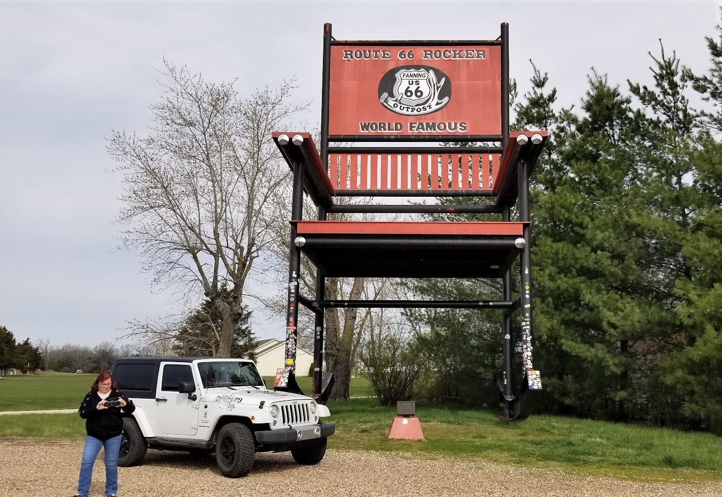
Just a few minutes further in the town of Fanning is our next geocache (GC1G43E). The Rockin' on Route 66 cache brings you to the Fanning US 66 Outpost and the World Famous Rocker seen at the top of this blog post. After a few photos and finding the geocache, we started to drive off.

At the same time I took a drink from my McD's iced coffee I just purchased a few miles back in Cuba. I think I only got 3 or for sips from it as it was more ICE than coffee! So I looped right around and parked back by the Outpost. We went inside to see if they had some bottled Starbucks or Dunkin coffee to pour into my cup. Yep! We ended up spending much more as we walked out with the coffee, a few novelty soda's and some homemade fudge. The proprietor was also very friendly and welcoming. I highly recommend that you be sure to take a look around inside the Outpost as well after getting your required Rocking Chair photo.


While staying on the Old Route 66 can be very interesting, it is also a slower pace and very time consuming. We still have to get to Texas for the next project before too long. Since I already had a geocache found in the next county, Phelps, I jumped back onto the parallel I-44 to quickly put some miles behind us.

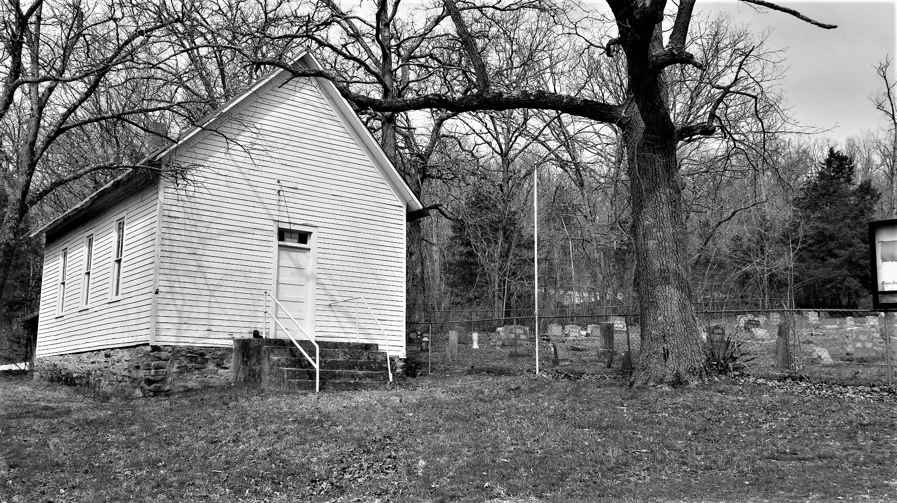
Exiting back off into Pulaski County, we make a stop for our next geocache and our first ghost town in a while. "A Gathering of Hookers" geocache (GC174AZ) brings you to the only remnants of the small community that was once called Hooker, MO. Built in 1900, this church building and cemetery are the only evidence of the early pioneers. The slow curving Old Route 66 (1926-43 alignment) passed by right in front of the church. When the new and improved 4-lane US-66 was built (1943-77 alignment), it was straightened and by-passed many of these communities.


A few Route 66 curves later and we arrive at the Devil's Elbow. A small lumberjack settlement began here after the Civil War around 1870. The name derived from a tight U-shaped bend in the Big Piney River. When the lumberjacks would send their logs downstream, they often got jammed up in "a devil of an elbow," which became known as Devil's Elbow.

Also here at the Devil's Elbow are my next three geocaches (GC175JD, GC1TG2P, GC17E9W). I'm just gonna give you a brief description of my two photos below before telling you about a great web page to go look at for more. This bridge was actually built in 1923 as part of the MO-14 state road connecting the communities. Three years later it became part of the original Route 66 alignment. However with the 4-lane realignment of Route 66 in 1943, came a new bridge. This was used only for local traffic and without regular maintenance, it was eventually condemned. Route 66 enthusiasts saved, restored it in 2013, and now open for vehicular traffic once again.


Following the curve around a half-mile to higher ground you get a good look at a section of the Big Piney River where the double truss railroad bridge crosses over.


Now for more historical information and lots of old and new, before and after photos, if you really get into history like I do, take a look at this web page I found on the Devil's Elbow community. It's a quick read and along with the photos and map will give you a better understanding of the Route 66 alignments. As well as some of the businesses that came and gone, and a revealing photo of the 2017 flood.

Making my way further westbound, we arrive in the town of Waynesville, still in Pulaski County, and our next two geocaches. The "Wire Road Stop" virtual geocache (GCE7E0) brings you to an old Stagecoach Stop listed on the National Register of Historic Places. Originally built as a complex with two log cabins in the 1850's, it was later rebuilt with wood in the antebellum style. A stagecoach stop for the Burden and Woodson Stage, also a tavern, used as a hospital during the Civil War, and a hotel after the war. Later abandoned and rundown it had been condemned by the city in 1982. Local citizens got together and saved the historical building. It is now the Old Stagecoach Stop Museum.


The other geocache was at the Talbot House (GC46FPX). One of Waynesville's oldest homes, it was constructed in 1885 by the Rev Albert Washington Davis. Dr. C.A. Talbot purchased the home in 1915 and used it as a residence for his family as well as an office for his medical practice for the next 30 years. After his death in 1945, his widow then rented rooms to boarders. Today, the current owners use it as an Antiques, Collectibles, and Gift Shop business.


Moving on down the road into Laclede County and some more geocaches along the Mother Road. The Gasconade River Bridge (GC8V6TP) is next on the list. I love these old bridges. Like the Devil's Elbow Bridge, this bridge was built during the construction of Missouri's State Highway 14 a few years before Route 66. And again with the new expanded 4-lane Route 66, the lack of maintenance and repairs led to the closure and condemnation by the state in 2014. The Route 66 enthusiasts are trying to rescue and restore this bridge as well.


My next two geocaches are in Lebanon, MO. A quick stop and find for the Graffiti Tunnel (GC8AVN3).


The other geocache has over 500 favorite points and is the second largest cache that I've ever found, with the old Space Coast Geocaching Store cache in Florida being the largest. This one is called Jolly Green Giant (GC1MDCE) and is Missouri's largest ammo can.


There was just one more geocache we stopped for right before leaving the county. Nothing really to see here. But it was a Challenge cache (GC41F8V) that required you to have found a cache in at least 25 states before claiming the find. Well we've found one in 49 states, so I figured I'd stop quickly and sign the log sheet.

Another chance to make up some time as we already have Webster County, I jumped onto I-44 over to Greene County. There were two geocaches (GC2ZFAA, GC2Z72F) near the intersection of I-44 and US-65 that had some favorite points because of their creativity. They were easy to get to and easy to find. Had an interesting containers. What I liked most and wasn't even mentioned on the geocaching listing, was the historical pioneer cemetery just down the short trail.

It was the Union Campground Cemetery which was established in 1840 by the Presbyterian Church for open air camp meetings. Historical research by locals and decedents put the number of burials at around 200. However, documentation has only confirmed 84 burials.


Staying on the Interstate to get through Springfield, I took the first exit into Lawrence County to once again pick up the Old Route 66. Knowing that Route 66 was being built to the west following the old stagecoach trail, Sydney Casey purchased some property in 1925 in the small community of Spencer near Johnson Creek. There he built his businesses in a row of connected buildings, kinda like a mini shopping center. There was a gas station / garage, barber shop, cafe, and grocery store.


Strategically placed on the right just past the Johnson Creek Bridge (GC7TE1D) which was built two years earlier, Casey was open for business from the Route 66 travelers crossing the bridge. Looking west through the bridge, you can just make out his shops on the right past the Jeep. Then another 1/4 mile beyond and further up the hill was the Camp Lookout Cabins for the weary travelers looking for a break from the road.


The businesses prospered until the new Route 66 alignment a couple miles to the north bypassed this section of the original roadway in 1960. Then eventually killed any thru traffic with the construction of Interstate-44. The cabins no longer exist except for a couple of the foundations can be seen in the grass. Fortunately with the historical interest and fans of Route 66, what does remain here in Spencer has been rescued and slowly restored. Along with the geocache on the bridge, there are 4 easy multi-caches going up the hill using clues gathered from the shops (GC7RPV0, GC7RPY7, GC7RPZ0, GC7RQ04).

Passing through west into the community of Phelps, I spotted this old school building. The Phelps School was a one-room school built in 1888. Classes were held there until 1952. It was later abandoned and fell into disrepair in the 1980's. Eventually the community got together and restored it.


Entering into Jasper County and approaching the town of Carthage, we arrive at our next geocache. The Jalopy (GC4QMA6) is another example of artist Lowell Davis creations, an old car driven by a hillbilly and his hound dog.


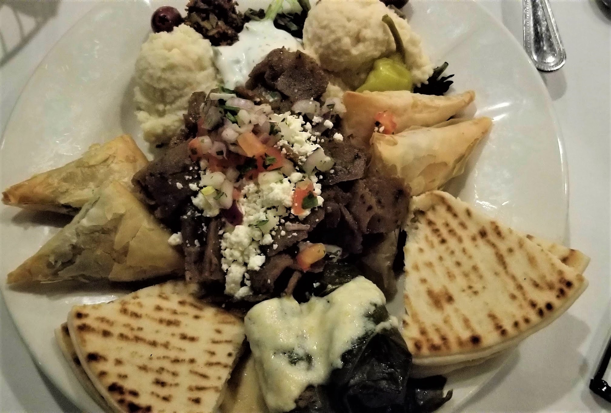
Well that's our quick tour of Route 66 through Missouri. One day in the future, probably after retirement, we'll get to take a slower and complete roadtrip stopping in all the small communities. But it's late now and we made it to Joplin. Believe it or not we found a great Greek restaurant called Mythos. Time for a bite to eat and then get some sleep! She got the grilled chicken salad and I got the sampler platter.


To follow along on our travels and keep up with my latest blogs, you may do so here of course by clicking the "Follow" button to the right. But also by using one or more of your favorite of these social media platforms: FacebookMeWeGabRedditParlorTwitterGETTRInstagram, and TruthSocial. These all link directly to my profiles. Again, please feel free to comment and / or share.

Thursday, March 30, 2023

2021-03-30: Visiting history in St Louis, Missouri via Route 66 and the Gateway Arch on Day 8 of our 3404 Roadtrip Adventure

Welcome back friends! Today we finally make it out of the State of Illinois, cross over the Mighty Mississippi River, and into St. Louis Missouri. We'll pay our respects to some notable figures buried in the Bellefontaine Cemetery and I finally get a chance to stop for a visit to the St Louis Gateway Arch. So hop on board as we continue to Geocache through history...


Our first stop was a quick geocache (GC50RQ2) find in Greenville, Illinois to mark our overnight stay and getting a find for Bond County.

Then we jump onto I-70 westbound. Instead of taking it all the way into St Louis, we detour onto the northern I-270 route. This not only takes us into Madison County, IL, but also over to the Route 66 Chain of Rocks Bridge and an Earthcache (GC68M54). Over its 50 year history, Route 66 crossed the Mississippi River at five different locations: 1) McKinley Bridge, 2) MacArthur Bridge, 3) Old Chain of Rocks Bridge, 4) MLK Jr Memorial Bridge and 5) Poplar Street Bridge.


This crooked crossing spanning the Mississippi River was a memorable passage for Route 66 travelers. The privately funded bridge was built in 1929 as a toll bridge. The distinctive 22-degree bend in the middle resulted from the need to build on solid rock footings on the river floor. Eventually turned over to the city of Madison, IL, it became the US-66 Northern Bypass from 1936-1965. In 1967, the New Chain of Rocks Bridge opened just to the north replacing this one to vehicular traffic. Now it is a pedestrian / bicycle bridge. We walked out to the center where Illinois meets Missouri where there was also a virtual geocache (GC2258).


There is also one stage of a 5-part Adventure Lab Cache here. We were only able to complete the one question as the other 4 stages were back in the other direction and I'm not backtracking.

These two structures you see here are just south of the bridge and look like they're a couple of secluded castles. In reality, they are water intakes for a series of locks and dams for the Chain of Rocks Canal to the east. This 17-mile section of the Mississippi River is very treacherous to navigate with its rocky bottom. In the 1940's-50's, the Army Corp of Engineers created a straight canal on the eastside of Chouteau Island to make it easier for ships and barges to navigate and bypass the rocky rapids.


Next we looped up, around, and crossed the mighty river on the New Chain of Rocks Bridge into Missouri. Our first stop over here was in the Bellefontaine Cemetery just a few miles in. So there was one gravesite we came to see. But upon arriving, we discovered there was so much more history here to see. Such as...

... William Clark (GC7B7DX) of the Lewis and Clark explorers. Born in Caroline County Virginia, Clark moved with his family to Louisville, Kentucky in 1785. In 1789, he joined the militia. He was commissioned a lieutenant in the regular army in 1792. One of the men briefly under his command was Meriwether Lewis. Clark left the army in 1796. In 1803, Captain Meriwether Lewis invited Clark to share the leadership of a corps of exploration in an extensive journey into the vast uncharted area newly acquired by the United States with the Louisiana Purchase. Clark acted as mapmaker and artist, portraying in great detail the life they observed.


After Clark's successful return from the Pacific coast three years later, President Jefferson awarded him 1,600 acres and made him Brigadier General of militia for the Louisiana Territory as well as superintendent of Indian affairs. He held that post the rest of his life. From 1813, he served as governor of the Missouri Territory. Clark died in St. Louis where a 35-foot gray granite obelisk was erected to mark his grave.


The Wainwright Tomb is one of Bellefontaine Cemetery’s most well-known mausoleums. It was designed in 1891 by renowned architect Louis Sullivan. Entombed here is Elis Wainwright, a millionaire brewer who lived from 1850 – 1924. He’s also known for the Wainwright Building in downtown St. Louis, one of the world’s first skyscrapers. Notably, Louis Sullivan designed that too. But the tomb was originally constructed for his wife Charlotte who’d passed away at the age of 34. Wainwright would then go on the run to Paris after being indicted in a bribery scandal. Decades later, he was finally entombed next to his wife upon his death.


The grave of Herman Luyties (1871 – 1921) is among the most unique at Bellefontaine Cemetery. And it has a rather creepy backstory. Luyties, the owner of the first drug store in St. Louis, took a trip to Italy at the turn of the 20th century. There, he fell in love with a model who ultimately rejected his proposal for marriage. But Luyties couldn’t let her out of his mind, and he even commissioned a sculptor to immortalize his former lover in stone. Now, in some form at least, Luyties can lie forever with the woman who wouldn’t have him. Over time, the marble statue gradually eroded due to weather, and so it was later placed in the glass box we see it in now.


Adolphus Busch (1839 – 1913) was a well-known brewer who ran the Anheuser-Busch Company with his father-in-law, Eberhard Anheuser. And like Anheuser, Busch was also born in Germany. As a young adult he emigrated to St. Louis which was home to a large German community at the time. And that meant that there was also a large market for beer. Following Anheuser’s death, Busch became president of the company. And thanks to his marketing expertise and innovations like refrigerated freight cars, he helped Budweiser become a nationally recognized beer brand in the 19th century.


Today at Bellefontaine, the Busch Mausoleum is one of the more notable tombs on display. It was designed by the Barnett, Haynes & Barnett architectural firm in the Bavarian Gothic style but made with local stone. It supposedly cost around $250,000 to build at the time, which equates to over a couple million dollars today!


The main reason for stopping by this cemetery was to visit the gravesite of Rush Hudson Limbaugh III. The majority of people know the name, many who listened loved him, and the others who only know what was told about him probably hated him. Rush was a radio personality, political commentator, and author. He got his start in radio in 1971 at radio station WIXZ as a DJ in Pennsylvania reporting "farm news." Within 18 months, however, he was fired due to a "personality conflict" with the program director. He went through a number of radio stations, working as a deejay and a talk show host, but it wasn't until 1984, when he became famous with his radio show on KFBK in Sacramento, California. He could voice any opinion he felt, regardless of how controversial.

(At the time of our visit, Rush's headstone had yet to be installed.)

His show was picked up by ABC-Radio in 1988, now being broadcast all over the country for what would be over three decades. It eventually rose to 600 stations and 27 million weekly listeners. Limbaugh was inducted into the Radio Hall of Fame in 1993 and the National Association of Broadcasters Hall of Fame in 1998. Additionally, he was a five-time winner of the National Association of Broadcasters Marconi Award for Excellence in Syndicated and Network Broadcasting. Limbaugh's unabashed love of country and belief in American Exceptionalism caused detractors to seek controversy in every broadcast.

He was well liked for his charity work, using his show for the annual Leukemia and Lymphoma Society Telethon and the Marine Corps–Law Enforcement Foundation. He also was not afraid of poking fun of himself, voicing himself in cameos for three episodes of Family Guy.

Limbaugh, a cigar and former cigarette smoker, was diagnosed with lung cancer, eight days after his 69th birthday. On February 4th, during President Donald Trump's State of the Union Address, he awarded Limbaugh the Presidential Medal of Freedom. After his lung cancer diagnosis, he continued working on his radio show as much as he could. "I told the staff that I have a deeply personal relationship with God." Limbaugh died on February 17, 2021, at the age of 70.

(A more recent photo with the headstone.)

Continuing south for several miles along the banks of the Mississippi River into St Louis, we finally found a parking spot a few blocks away from the Gateway Arch (GC7ED). Along the way we spot the Tom Sawyer River Boat getting ready to pass underneath the historic Eads Bridge. This was the first bridge across the Mississippi at St. Louis. It was a major engineering feat, the largest bridge built at that time and the very first steel bridge. Completed in 1874, it is the oldest bridge standing on the Mississippi River. It was designed and built by James Buchanan Eads, an engineer famous for his ironclad gunboats built for the Union in the Civil War.


Nearing the Arch, we pass by this statue of Lewis and Clark and their dog coming ashore after crossing the river during their expedition.


During my days as a truck driver, I used to pass through St Louis on Interstate 40 often and could only get a view of the Gateway Arch out my window. I had always wanted to stop for a closer look, but parking a 70' long 18-wheeler within walking distance in downtown St Louis is probably not an easy task. Now, finally, we are able to get an up-close look at this monument.


Now for some history and facts. The St Louis Gateway Arch (GC7ED) is 630 feet tall and 630 feet wide at it base. The idea for a memorial to commemorate the western expansion of the United States began to take shape in 1933. On June 15, 1934, President Franklin D. Roosevelt signed the bill into law, instituting the United States Territorial Expansion Memorial Commission. In December 1934, the Jefferson National Expansion Memorial Association discussed organizing an architectural competition to determine the design of the monument. Local architect Louis LeBeaume had drawn up competition guidelines by January 1935. On December 21, 1935, President Roosevelt signed Executive Order 7253 to approve the memorial and 82-acre National Historic Site.


On February 18, 1948, Eero Saarinen's design was chosen from among the initial 172 entries in the design contest. After much deliberation and planning, the official groundbreaking ceremony finally occurred on June 23, 1959 at 10:30 AM. The first order of business was to build a tunnel and reroute the railroad tracks. In 1961, the foundation of the structure was laid and construction of the Arch itself began on February 12, 1963 as the first steel triangle of the south leg was set in place. The arch's visitor center opened on June 10, 1967, and the tram began operating on July 24. Upon it's competition, the arch became the tallest memorial in the United States and the tallest stainless steel monument in the world. The official dedication ceremony was finally held on May 25, 1968 by then Vice-President Hubert Humphrey.

Because of its tight quarters inside and limited exits, the Secret Service has forbidden all Presidents from ascending the Gateway Arch due to security concerns. The only exception was made in 1967 when he was 77 years old, former President Dwight D. Eisenhower was in town to give a speech. He had signed the order for the construction of the Arch in 1954. He paid a visit to the site after it had already closed to the public and insisted he get a ride on the tram to the top.

One more stop in St Louis before leaving the downtown traffic. I've played the game of chess since I was a kid. I taught my two sons when they were young. And when they started in a private Christian School, I formed and hosted the Chess Club for 2 years. So when I saw this virtual geocache at the World Chess Hall of Fame, we just had to stop. Outside they have the Guinness Record World's Largest Chess Piece (GC890GN) at 20 feet tall and a 9'2" diameter base and weighing in at 10,860 pounds!


Now to get out of the city to the rural open roads, find something to eat, and get some rest. To follow along on our travels and keep up with my latest blogs, you may do so here of course by clicking the "Follow" button to the right. But also by using one or more of your favorite of these social media platforms: FacebookMeWeGabRedditParlorTwitterGETTRInstagram, and TruthSocial. These all link directly to my profiles. Again, please feel free to comment and / or share.

Saturday, March 11, 2023

2021-03-29: Touring More Abraham Lincoln and Route 66 Sites in Illinois on Day 7 of Turning a 1400 Mile Road Trip into a 3404 Mile Adventure!

So today as we geocached more Illinois counties, we followed more footsteps of President Abraham Lincoln historical sites and jumped onto the Historic Route 66 to continue our southwest roadtrip. There's a LOT to see and do today, so let us go for a drive and get on down the road...


Waking up in Peoria County, Illinois this morning, it was still cold but not like it was yesterday morning. First thing first... breakfast, coffee, and hey look there's a geocache right there in the parking lot (GC42BCA)! Then next door into East Peoria and Tazewell County, we made a quick exit off the highway in this industrial area for a creative geocache (GC24KTM) that had a lot of favorite points. Luckily, truck traffic wasn't that busy. Parked on a side street and a short walk across the grass. Found the container quickly and another minute to figure out log sheet retrieval.


Southbound on I-55 into Logan County, we exit into the small town of Elkhart. A couple of blocks off of the Old Route 66 and near the town square, is this Veterans Memorial Statue honoring those in the community who have served in the various wars.


Just outside the east side of town are my next two geocaches (GC4MYJP, GC8P1YG). The first settler in the Elkhart area was James Latham. In 1824 he was appointed by President John Quincy Adams to the position of Indian Agent at Fort Clark (now Peoria). He moved the family there and in two years took ill and died. They brought him back to the hill and buried him in Latham Cemetery (not far from where his first cabin was built) which has the distinction of being the oldest cemetery in Logan County.

One of the highest points in the state is Elkhart Hill. Abraham Lincoln often stayed in the Kentucky House, a stagecoach stop on Elkhart Hill owned by his friend Richard Latham. He was also a friend of John Dean Gillett, who was once known as the “Cattle King of the World.” Gillett was the primary financier of Lincoln, IL, the Logan County city that bears Abraham Lincoln’s name.

The Elkhart Cemetery is located on the south side of Elkhart Hill. Near Gillett’s grave, is the Saint John's Chapel. It was built in 1890 by the Culver Stone Co. in memory of Gillett. Still owned by the Gillett Farm, it is the only privately owned chapel in Illinois.


Richard J. Oglesby, three term governor of Illinois and a close friend of Abraham Lincoln, married the Gillett's oldest daughter, Emma. They built their home across the hill from the Gillett house. Known as Oglehurst, the 46 room mansion had a pipe organ in the Great Hall, a fourth floor school room where the children were tutored and a music room with a musical score detailed in the gesso work around the ceiling. The Oglesby's are buried in a tomb on Elkhart Hill.


The cemetery is also the final resting place of Capt. Adam H. Bogardus, who toured with Buffalo Bill Cody’s Wild West Show and was known as the “Wing Shot Champion of the World.”

Connecting Elkhart Hill to Elkhart Cemetery is this bridge which was erected in 1915 by Emma Gillett Oglesby. It is said to be the only private bridge over a public highway in the state. 


This time I decide to stay on Old Route 66 instead of jumping onto the Interstate. Crossing over into Sangamon County and the town of Williamsville, I spot The Old Route 66 Gas Station and Garage. I couldn't buy gas at 31 cents a gallon, but I did drive away with some good photos.


Now moving down the road into Springfield, Illinois. Settling began in 1810 and eventually the town of Springfield became the state capital of Illinois. Abraham Lincoln lived in the Springfield area from 1837 until 1861. In May of 1839, construction began on this cottage for Reverend Charles Dresser. It wasn't until 1844 when Abraham Lincoln moved his family, wife Mary and son Robert, from a rural community on the outskirts and purchased a small cottage house within Springfield. The Lincoln's made multiple renovations and expansions over the next 17 years while they lived in the home. In 1861, now President Abraham Lincoln moved the family to Washington D.C.


Several tenants occupied the house up until Robert Lincoln deeded the house to the state of Illinois in June of 1887. President Nixon established the house as the Lincoln Home National Historic Site in 1971/72 (GC963C).

Pictured below is Abraham Lincoln's "campaign bus" which he used to travel around in while running for office. A big difference compared to today's 45 foot luxury motorcoaches!


Two blocks away from the Lincoln House is Union Square. Union Station opened in 1898 as the passenger terminal for the Illinois Central (IC) Railroad. Francis T. Bacon, an IC architect, designed the station. The current 110-foot-tall clock tower is a reconstruction replacement of the original which was removed in 1946.


Vacated by the railroad in 1971, Union Station was rehabilitated by the Scully family in 1985 for retail use. The State of Illinois leased the building for offices in 1990, eventually purchasing it in 1990. A rehabilitation began in 2005 returning the train station to the turn-of-the-century appearance.

On this public square and in surrounding buildings (GCMNH3), Lincoln and his family and friends purchased goods, attended parties, enjoyed picnics and parades, watched theatricals, and listened to concerts and lectures.


In law offices and courtrooms overlooking this square he honed his skills of persuasion. In storefront discussions and street corner gatherings he perfected the art of politics. Then, as his understanding matured and his convictions deepened, he took his place among the leaders of his time, addressing the people of the nation in powerful and eloquent words that echoed beyond this small prairie capital.


Our next stop in Springfield, Illinois along our President Abraham Lincoln Sightseeing History Tour was at the Oak Ridge Cemetery. Upon entering the cemetery, there are multiple veterans memorials near the entrance. This one pictured below is the Illinois Vietnam Veterans Memorial (GCE6FF).


After Lincoln's assassination and services in Washington D.C., his body was placed on a train for his final trip back home to Springfield. His casket, along with his son Williams who died at the White House in 1862, was placed in this receiving vault at the Oak Ridge Cemetery in May of 1865. They remained here under guard until December of 1865 when the construction of another temporary tomb was completed.


The granite monument below, erected in 1900, memorializes the location of the temporary second tomb. The temporary vault held the bodies of President Abraham Lincoln and his sons Edward and William from December 1865 until September 1871, when they were moved to the partially completed tomb. Built into the lower portion on the left side of the monument, is the marble slab which used to be inside the receiving vault upon which his casket was first put to rest. (looks like a white door in the photo)


In 1871, three years after construction began, Lincoln's body and three of his sons were placed in crypts in the unfinished structure. The memorial was completed in 1874. Now, you would think that this was the FINAL resting place of President Abraham Lincoln. However, I leave you to read "the rest of the story" as Paul Harvey used to say. Go to the National Park Service website to read about the attempted theft of Lincoln's body and that it was moved 5 more times before being placed ten feet below the floor of the burial chamber as requested by his only remaining son, Robert Todd Lincoln.


In the center of the chamber is this huge sarcophagus, ten feet above Lincoln's body. Along the back wall are five chambers, one for his wife Mary Todd Lincoln, three of his four sons, and a grandson.


Finally moving on into Decatur and Macon County. This Texaco Gas Station (GC7B80A) originally opened in the 1930's. Having changed hands several times, it eventually became an automotive detail shop. The building was in pretty bad shape until the current owner purchased it. Over a period of 6 years, the property was brought up to code and the whole place was restored to it's original 1930's state you see today. The station is slowly being filled with period equipment and furniture. The only thing missing now is the gas pump itself.


Also in Decatur at the Greenwood Cemetery is the Illinois Tomb of the Unknown Soldiers Memorial and another geocache (GC32HMJ).


Heading southeast down State Road 121 into Moultrie County, we make a quick geocaching roadside stop (GC3MV8K) at the Illinois Department of Natural Resources Public Archery Range.

I had decided to take this little detour south-eastward before continuing southwest in order to stop for more historical places along the Lincoln History Tour.

Reaching Coles County near the towns of Lena and Campbell, is our next geocache (GC1MEC5). It is here where you'll find the Shiloh Presbyterian Church and the Thomas Lincoln Cemetery. Thomas Lincoln died in 1851 and was buried in what was then called the Gordon Burial Ground. As was common in many poor rural communities, Thomas Lincoln's marker was probably no more than a simple rock placed to mark the gravesite. Many years later, however, Abraham Lincoln's nephew, John J. Hall, would tell a Lincoln biographer that Abraham had carved the initials T. L. onto a board which he placed upon the grave during his last visit in January 1861 before heading to the White House.


Whether Thomas Lincoln's marker was a stone or a board, no permanent marker could be placed by local friends and by Thomas' grandson, Robert Todd Lincoln. Those donation ensured the tombstones eventual erection in 1880. The current marker was actually installed later by the Illinois Lions Club to replaced the original, which unfortunately, had been chipped away at by souvenir seekers over the years.


Located on the Lincoln Highway, just down the road from the cemetery, the Lincoln Log Cabin State Historic Site preserves the last farm and home of Thomas and Sarah Bush Lincoln. The Lincoln family moved to the farm in 1837 and after Abraham had established his residence in Springfield. Although Lincoln never lived here with his father and stepmother, he stopped here to bid farewell to his stepmother on his way to the White House in January of 1861. There are also three geocaches here on the Lincoln Farm (GC8B2NZ, GC8B2WM, GC891A4).


From the Lincoln Farm, we drove south towards I-70 because we were running out of daylight and needed to put some miles behind us. We crossed over into Cumberland County and the town of Greenup for our next county geocache. It was located at the Greenup Cemetery (GC5C8CE). Located along the Old National Road, burials date back to the early 1800's. No time to look but just a quick glance around. Nothing got my attention so onto the Interstate westbound.

We drove straight through Effingham County because I had already completed that one from back in my truck driving days. Then stopping in Fayette County for two geocaches. The first was in the Guy Cemetery (GC2J8TY) in St Elmo. Again just a quick glance around and moved on.

Two exits later, we got back off into the town of Vandalia for a geocache with hundreds of favorite points. The Great Kaskaskia Dragon (GCHWFZ) is this huge metal sculpture of a fire-breathing dragon and knight in armor. Unfortunately the dragon's fire had been extinguished during our visit.


Now the camera brightens it up a bit and, at 7:30 PM, it was darker than it appears. Time to find some dinner and get some sleep!