Sunday, January 31, 2016

2014-08-23: Florida's First Coast St Augustine and Anastasia Island

Today Candy and I took a drive up to St. Augustine to visit her family and do some sightseeing where she grew up. And of course we couldn't pass up Geocaching while we were here. We spent most of the time at Anastasia State Park.

Our first virtual cache was a short hike to the sight of the Old Spanish Quarries where much of the Coquina was retrieved to use in the construction of many of the early buildings. Including the fortress Castillo de San Marcos.


We continued hiking some of the trails and even went over to the beach side to enjoys the views. But we didn't stay long. It was August and we weren't exactly dressed for the beach.


The last Geocache of the day was called lighthouse view because it was in view of the lighthouse. It was a nice relaxing day enjoying the outdoors, hiking, and spending time with family.


2014-08-10: One Weekend / 1800 Miles!

While today's post may be short, it covered 1800 miles in just one weekend! During our summer road trip, we had dropped off Candy's grandkids at their father's house in Maryland. While the son was staying there, it was time to pickup the granddaughter. 

After work Friday night we quickly packed, hopped into the car and got a head start. We made it almost through Georgia and stayed the night in Richmond Hill, just south of Savannah.

On Saturday, we hit the road early and drove all the way up to Westminster, MD. With granddaughter in the car, we made our way back southbound. Just north of the Richmond, VA beltway I decided to call it a night.

Sunday came and we drove all the way back home to Florida. Wow, what a trip! From Google maps it was 1809 miles. Add in all the gas, food, and overnight stops and it was probably more like 1825 miles. Sadly the only Geocaching we managed was during the stops. Total caches for the weekend add up to only 5.

The one cool thing we found was on the way back. We stopped in Port Wentworth, GA for gas and saw a sign for Sweet Tea Grille. With a name like that how can you not eat there. Out front they had this huge chair which made for a nice photo opp!


2014-07-05: Geocaching With Friends Finding Virtuals and More

Today's Geocaching adventure takes us to Southwest Florida along with some Geocaching friends looking for virtual caches around the Ft. Myers area. This morning we started out early from Orlando and heading down US-27 to LaBelle, FL. There we met up with Geocachers CoalCracker7, the Corbettz gang, and MsYB to begin our adventure.

The first cache was called Giant Oaks and it was a short hike through the woods to find several large oaks. The ankle high grass was still wet from the morning dew and wearing sneakers it wasn't long before my feet were wet too.

CoalCracker7 and myself.
The next virtual cache on the list was called Bird Watching and it brought us to this lake with these two small islands in it. On the islands were thousands of these white birds that always hung out there. On the walk out to view the birds we passed by several huge oak trees with an abundance of Spanish moss hanging from their branches. After the short hike and a few photos, we headed off to the next one.


MsYB with the Corbettz kids taking the lead.


Not far down the road was the Port LaBelle Marina and our next virtual cache. A quick stop, more pictures, and we continued on.


Next on the agenda, another virtual cache and the largest oak tree in Hendry County. A quick photo and then we headed north of town a few miles to a cemetery and another virtual cache. Don't know much about the cemetery. Here's a photo of the oldest marker found.


From LaBelle, we headed west over towards Ft. Myers. Along one of the back roads, we passed by an old fashioned cattle roundup and had to stop and take a picture.


On the outskirts of Ft Myers, we stopped by the WP Franklin Lock and Dam Complex for an Earthcache on the Caloosahatchee River. The goal here was to learn about the history of the river, the oxbows, the locks and dam. We gathered the necessary information required, watched a boat pass through the locks, and enjoyed the views.

MsYB, CoalCracker7, and Corbettz
The next few on the list of virtual caches were stops at Lee County Park, the Fort Myers Cemetery in search of a malicious killer, First Street, and then the Edison and Ford Winter Estates.

Corbettz crew looking for Edgar J
 
MsYB with Thomas Edison at the HUGE Banyon Tree
After finally finding all the virtual caches in the area, we headed over to Veterans Memorial Parkway for a quick 20 cache power run before heading home. Another great day for fun, adventure, history and Geocaching with friends. Until next time...

Hmmm,,, maybe I'm looking in the wrong spot?


Friday, January 29, 2016

2014-06-14: Road Trip Day #8 From Georgia to Home in Florida

Home Sweet Home! We set out from North Georgia this morning on our last day of the road trip. And our last chance to see what we can see. We continued to follow US-19 south for the most part. Whenever we saw a new county sign, we looked at a Geocache to find in that county. Our Geocaching finds for the day totaled 15. Most of the Geocaches were nothing special, but they did give us a find for the county.

This next cache took us to a piece of history. The Auchumpkee Creek Covered Bridge in Culloden, GA was built in 1892. With the construction of the new road and modern bridge along side, the covered bridge was no longer used. The Upson County preservation commission authorized its restoration in 1985.


Several more Geocaches along US-19 southbound, we crossed over into Florida. By this time it was just looking forward to getting home. Once we hit I-10, we jumped on eastbound over to I-75 south. A few hours later it was home sweet home.

Now we need a vacation to recover from our vacation!

2014-06-13: Road Trip Day #7 Virginia, Tennessee, North Carolina, and Georgia

On this seventh day of our summer road trip, we ended up driving through Virginia, Tennessee, and North Carolina. We continued following US-19 southbound and Geocaching along the way. We managed to find 12 for the day at various stops.

After a couple of Geocaches, I saw this virtual cache pop up so we turned off of US-19 for a few blocks to take a look. This water wheel was out at the edge of this Geocachers own property. 


These next few photos are of Spivey Creek in Tennessee at the site where once stood the Tilson Grist Mill. The mill itself has since been removed, restored, and now sitting in the Tennessee State Museum in Nashville. But a Geocache has been hidden here to mark the spot.


Continuing down the road crossing the border from Tennessee to North Carolina at the town of Bristol, there's a giant guitar in the center of town. That definitely a photo opp! So we quickly pulled over for a closer look.


This next stop is another virtual cache next to Cold Springs Church. This natural cold water spring continues to flow 24 hours a day. The locals even bring their jugs and containers here to refill for free fresh cold spring water. Sure beats buying bottled water in the store.


After the water falls into the drain below the deck forms this creek.
Still winding through the Smokey Mountains, we stopped for another Geocache and a scenic view at the Pattons Run Overlook along the Nantahala River in North Carolina. After finding the cache near the parking area, we took the short hike down the trail to the rivers edge. It was a beautiful hike and listening to the rushing waters was very relaxing. A great place to stretch the legs.


Our last stop and a virtual Geocache was a monument located in Murphy, NC. The monument marked the site of the former US Army post Fort Butler, where the Cherokee Indians we gathered to begin their relocation march known as "The Trail of Tears." Here at the confluence of the Valley and Hiwassee Rivers, General Winfield Scott commanded the relocation forces and used Fort Butler as his headquarters.


From there we continued south on US-19, crossed over into Georgia and stayed the night in Dahlonega, GA. Another great day full of history, Geocaching, and scenery.

2014-06-12: Road Trip Day #6 Pennsylvania, West Virginia, and Virginia

So this morning we're still in Western Pennsylvania, we have four days left to get back to Florida and no specific things to see or do. But I do know that it's time we must be heading south. If we just hit the Interstate, we can be back in two days. As I'm looking through Google maps trying to decide which route to take, I noticed US19 just south of Pittsburgh. US19 goes all the way down to Tampa, FL. So I decided we'll just follow US19, stay off the Interstate, and see what we'll find.

Throughout the day we managed to find 13 Geocaches at various stops along the way. Mostly during food or gas stops and nothing really to note about. We saw some small towns and scenic views of hills and mountains. For most of the day it was overcast and wet, so not many photos either.

The first place worth mentioning was this old US-19 bridge crossing over the Birch River from 1916. Located in Birch River, WV, it has long been replaced with the current 4-lane bridge that makes the US-19 highway. It's nice they kept this old piece of history in place.


Further on down the highway, we did cross over the New River Gorge Bridge in West Virginia. Even though there was a lite rain, we did stop for a quick look from the rest area. The New River Gorge has become a National Park. The bridge is the longest steel span in the western hemisphere and the third tallest in the United States. It is one of the most photographed places in West Virginia. Too bad the weather wasn't cooperating.


After crossing the border into Virginia, we got a bite to eat, found a hotel and called it a day. Thanks for following along with our adventure. See you tomorrow.

2014-06-11: Road Trip Day #5 Hiking the Rails in Pennsylvania

Today is another big day! Not only is today my birthday, but today we're setting out to get a Geocache that has been on my watchlist for a couple of years. Another example of Geocaching bringing you to some really cool places!

If you were visiting western Pennsylvania or even Pittsburgh, you probably wouldn't have any idea this place was even here. It's not a tourist area. There's no signs directing you here. So unless you're either a local or a Geocacher, you'll probably miss out on this great adventure.

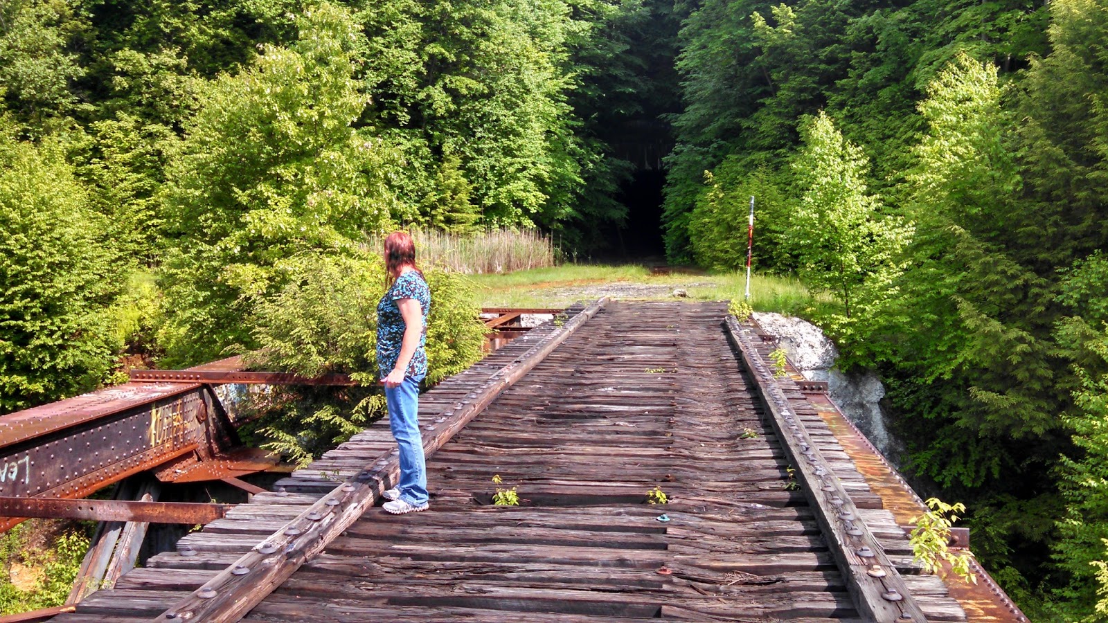
Just a few miles off of I-80 near the town of Clarion, NE of Pittsburgh, remains the remnants of a bygone era. The rails and ties that run through the woods have been removed. But the tunnel and the train trestle bridge remain. High above the Clarion River is the Clarion Trestle. Only used now for hikers, adventure seekers, and probably some party goers too.

After exiting the Interstate, we drive a few miles through some winding back roads until we reach the small pull off area for parking. I grab the backpack with water and flashlights and we begin the climb up the hill to the level ground where the tracks used to lay. Its not long before we see the eerie dark hole into which we must pass through. You don't realize the size of the tunnel until you reach the entrance. It was huge. Then excitement continues to build as you look into the darkness and see the tiny light coming from the other end.


I didn't think to measure, but the tunnel must have been 500'-600' long. It was damp and cool inside. And I didn't smell or hear any bats either, so that was good. Once we pass through the tunnel, we see the trestle bridge high above the river. Also, this side of the mountain seemed a bit foggy with a lite drizzle of rain. We started to venture out over the bridge, but the wooden R/R ties seemed a little slippery and damp. So we decided to follow the path running parallel to the river to get the Geocache. It was about a half mile hike through the woods with the last 200' going up the side of the hill.


After hiking out of the woods and back to the bridge, the sun had come out and began drying things off. So we felt a little safer out on the wooden beams and we decided to go walking out further and enjoy the views from high above the river. You just can't do this on most train trestles because they're still in use. You get caught in the middle of the bridge and a train comes, you got nowhere to go. Here you can take your time and enjoy the views, the peace, and the serenity.


And now for the really spooky part. With the sun shinning, warming the air, and high humidity, the cool damp air from within the tunnel began pouring out in a fog like a flowing river. And once inside the tunnel, the fog just filled the whole thing. The first time walking through you could at least see the other end. This time you couldn't see but 20' ahead. Kinda like driving through a thick fog at night with your headlights on. When we got to the center, we turned and looked in both directions and you could not see the outside.


Continuing to press on, we finally began to see the light at the end of the tunnel and made it back to the car. Across the street was another small creek. Beyond the creek you could see that there were several cement support structures that one held the railroad tracks crossing over on that side. They were probably 25'-30' tall. There was also a Geocache atop of one of those, but we hadn't anyway of climbing to reach the top of it.

On thing I learned was to always check ahead of time, even at the last minute, for any additional caches. Down in that little valley among the back roads, I lost cell phone service. Even with Verizon! Anyway, I had only written down and programmed those 2 caches from when I first started watching them. If I would have checked again that morning, I would have noticed that there was another Geocache located right at the bridge. Just a little hike down the side of the hill to its base and we could have made it two cache finds there. Oh well... another time.

We managed a couple more simple Geocaches that afternoon, but called it an early day after the long drive yesterday and into last night.