Showing posts with label hiking. Show all posts

Saturday, January 15, 2022

2020-07-03: A Long Weekend Geocaching Counties and Hiking in Western North Carolina

Well we're working in North Carolina and have a 3-day holiday weekend. Do we chill at the RV Park or go exploring the Smoky Mountains and Geocache the remaining six counties to complete the state? It's a roadtrip of course! Grab the hiking boots, hop into the GeoJeep, and let's go sightseeing along the backroads of North Carolina!


Leaving the Lake Norman Motorcoach Resort behind for a few days, we headed west on NC Highway 18 until we got near Pleasant Grove. There we made a detour over to a bridge on Old North Carolina 18 for a First-to-Find attempt at a geocache published two days earlier (GC8VWYF). Another geocacher tried to find it the same day it was published without any success. I tried searching for nearly 30 minutes. But it wasn't for me to find on this day. I ended up having to log a DNF.

Driving north on US-321, I get off at the Mulberry exit for our next geocache (GC8MRYY). It was located near Silvervale Falls. These cascading falls are about 80 feet from top to bottom. Being this far from the Blue Ridge Parkway, there aren't as many tourists visiting these waterfalls. Only enough parking for 3 cars and we didn't have any problem. But worth the stop if you happen to be nearby.


One of the other reasons I like geocaching and traveling the backroads is that you never know what you might come across. Like this old rusty car, truck, and tractors lined up on the side of the road. I just had to stop and get a few photos.


Our next stop WAS to be Blowing Rock and then Grandfather Mountain. I've visited the Smokey Mountains and the Blue Ridge Parkway many times. However I have never made it to these two popular tourist destinations. Today it was going to be another of those times. It was July 4th weekend and the places were packed full and we did not want to contend with the crowds. So we continued on southbound down the Blue Ridge Parkway.

One of the first photo opp stops we took along the parkway was at the Wilson Creek Valley Overlook. A great view and you can see for miles!


Our next stop was a hike for a virtual geocache in the Linville Gorge Wilderness Area. The Linville Gorge Wilderness is part of the Pisgah National Forest. The gorge is formed by the Jonas Ridge on the east and Linville Mountain on the west and is bisected by the Linville River which drops 2,000 feet into the valleys below.

The virtual geocache (GC3A44) was a hike down the Spence Ridge Trailhead. This trail was supposed to take us down to the Linville River where we were to find the "House Rock," a flat top rock formation in the river that looks like a house. I wish I could show a picture of it, but we never made it. After about an hour of hiking, we were slowly getting closer but the destination appeared to be staying off to the right. Finally we decided to turn around and head back to the GeoJeep. As we were hiking back I noticed the correct trail we should have stayed on teeing off. Oh well, maybe next time.


Driving our way around to the other side of the Linville River we headed for our next virtual geocache called "Look At That" (GCG9YT). After 3.5 miles of gravel road, a little rough in a few spots, we made it to our destination at the Wiseman's View Scenic Overlook. Just a short walk from the parking area and you'll arrive at this viewing platform high above the gorge.


Driving back along the 3.5 mile gravel road, which is the Old NC 105 / CR 1238, I spotted this old road marker off the side in the weeds. After a few hours of research, Andrew Milton Kistler (1871-1931) was originally from Pennsylvania and became a prominent businessman in Morganton, Burke County, NC. First established in 1926 as the primary route between Nebo and Linville Falls, a 24 mile road that has since been rerouted and improved. The remaining Old NC 105 is now 17 miles of gravel road which can require 4x4 in some areas. That just added to the adventure in the GeoJeep.


We ended the day in Marion, NC. It was a pretty good day with the sightseeing, the hiking, the off-roading, and a little bit of history. I hope you have enjoyed todays adventure. See you back soon for another day of exploring the Smoky Mountains in Western North Carolina.

To follow along on our travels and keep up with my latest blogs, you may do so here of course. But also by using you favorite of these social media platforms: FacebookMeWeGabRedditParlorTwitterRVillageGETTR and Instagram. These all link directly to my profile. Again, please feel free to comment and / or share.

Saturday, January 1, 2022

2020-06-20: Taking a Trip Back to Mayberry and Andy Griffith's Hometown of Mount Airy, North Carolina

Welcome back friends, family, fellow traveler's, Geocachers, Jeepers, RV'ers, and ALL of you who've stopped by our AwayWeGo's Geocaching Adventures Blog. We're a couple of work travelers in construction and our job takes us all over the country. Currently, we're on a project in Central North Carolina near the town of Maiden.

Today was a great day to take a roadtrip back to Mayberry (GCJF95). Many say that "The Andy Griffith Show" was based on Mount Airy, NC, Andy's birthplace. So let's go for a drive and see what they've done to the town.

Mount Airy was settled in the 1750s as a stagecoach stop on the road between Winston-Salem, North Carolina and Galax, Virginia. It was named for a nearby plantation. Mount Airy was incorporated in 1885. The City's official seal was established in 1977, which depicts major industries that are home to Mount Airy including: furniture, textiles, and the granite quarry. In 1994, Mount Airy was named an All American City.


The Andy Griffith Show aired eight seasons on CBS from October 3, 1960, to April 1, 1968. The series originated partly from a prior episode of The Danny Thomas Show. The show stars Andy Griffith as Andy Taylor, the widowed sheriff of Mayberry, North Carolina, a fictional community loosely based on Mount Airy. Other major characters include Andy's cousin, the well-meaning and enthusiastic deputy, Barney Fife; Andy's aunt and housekeeper, Bee Taylor; and Andy's young son, Opie. Griffith said that the show evoked nostalgia, saying though it was shot in the '60s, it had a feeling of the '30s. It was, when we were doing it, of a time gone by."


Griffith was born on June 1, 1926, in Mount Airy, North Carolina, the only child of Carl Lee Griffith and his wife, Geneva. As a baby, Griffith lived with relatives until his parents could afford to buy a home. With neither a crib nor a bed, he slept in dresser drawers for several months. In 1929, when Griffith was three, his father began working as a helper or carpenter and purchased the home pictured below in Mount Airy's "blue-collar" south side. Griffith grew up listening to music. By the time he entered school, he was well aware that he was from what many considered the "wrong side of the tracks". He was a shy student, but once he found a way to make his peers laugh, he began to come out of his shell and come into his own.


The Mayberry Courthouse is a replica of the courthouse that appeared in “The Andy Griffith Show” during the 1960s. Situated adjacent to Wally’s Service Station, visitors can sit behind Andy’s desk, type on the vintage typewriter, and even sit in the recreated jail cells that appeared in the show.


Remember Sheriff Taylor’s police car? The one you saw in every episode? In Mount Airy, you can tour all of the sites in a Mayberry squad car. Each tour starts at Wally’s Service Station, then it will travel up and down the streets of Mount Airy. Wally’s Service Station is an original service station built in 1937 and operated as a Gulf Station and then later operated as a Standard Oil Station or Esso.


As a student at Mayberry Union High (Mount Airy High School), Griffith cultivated an interest in the arts, and he participated in the school's drama program. A growing love of music, particularly swing, would change his life. Griffith was raised Baptist and looked up to Ed Mickey, a minister at Grace Moravian Church, who led the brass band and taught him to sing and play the trombone. Mickey nurtured Griffith's talent throughout high school until graduation in 1944.


The Darlings (usually pronounced "Darlin's") lived in a mountain shack, like the one below behind Wally's Garage, somewhere in the mountains neighboring Mayberry. The good-natured, but trouble-making Appalachian clan, led by patriarch Briscoe Darling (played by Denver Pyle) usually came into town piled into the back of their old truck.


Though Methodists had been present in Surry County since the 18th century along with Baptists, Moravians, Quakers, and other religious groups, the original Methodist church in town was established only in 1831. The “Old Methodist” cemetery belonged to Mount Airy’s Methodist Episcopal Church, South, after part of the 1831 Lebanon congregation moved to a new location on South Main Street in 1858. The cemetery and church were built on land donated from Elisha Banner’s plantation, and the earliest burial dates back to 1857.


Local tradition says that the church’s bell, now housed in Trinity Episcopal’s belfry, tolled during funerals for every year of the deceased’s life. The cemetery acted as a town cemetery, not just for one for Methodists, and it was replaced by Oakdale Cemetery in 1892 when space began to run out. The church changed its name to Central United Methodist Church when it moved closer to the center of town in the 1890s, and the last burials at the Old Methodist Cemetery (GC4NZNT) were made around the turn of the century.


Leaving Mayberry, we drove down the highway on the way back but not before hiking Mount Pilot. Pilot Mountain was the inspiration for the fictional town of Mount Pilot in “The Andy Griffith Show.” Nearby the actual town is Pilot Mount State Park (GC88Z1Y) which is known for its Big Pinnacle peak seen for several miles. It was a nice short hike over to the observation deck where I got this great wide angle photo.


That was our return to Mayberry. It's one of those must visit towns if you're a fan of the of the TV show.

To follow along on our travels and keep up with my latest blogs, you may do so here of course. But also by using you favorite of these social media platforms: FacebookMeWeGabRedditParlorTwitterRVillageGETTR and Instagram. These all link directly to my profile. Again, please feel free to comment and / or share.

Saturday, August 28, 2021

2019-12-28: Spending the Day in Big Bend National Park

It's been 13 years since I was last here at Big Bend National Park in West Texas. Spending the last few years just a few hours north of here, I figured it was about time I paid another visit. We spent two nights in Alpine, TX as our base so we could get here early, stay all day, and not have a long drive home afterwards. Big Bend NP is over 1200 square miles and that's a lot to explore and see. So let's get going!


We arrived just after dawn to a cloudy morning which kinda hindered having some great sunrise photos. Our first geocache was an earthcache called "Fins of Fire" (GC3AZVV) facing the Chisos Mountains to the east, describing the layers and spikes and the creation of the mountains from volcanic activity.


Continuing the beautiful route down the Ross Maxwell Scenic Drive, we arrived at the Solol Vista Overlook and another earthcache (GC2NJRH). The amazing views here are awe inspiring. And from this vantage point we barely get a glimpse of our destination Santa Elena Canyon some fourteen miles in the distance. From here though it's just a tiny notch in the mesa across the valley.


In the panoramic photo below taken from the Sotol Overlook, from left to right are: Trap Mountain, Goat Mountain, Santa Elena Canyon, Kit Mountain, across the valley to Tule Mountain, Burro Mesa, Little Christmas Mountain, and Christmas Mountain.


After the overlook, we stopped at Tuff Canyon for another earthcache (GC72D1C). Tuff Canyon is the deepest of the dry washes in Big Bend NP. This also makes it very dangerous during or after a rain as the gathering waters pick up velocity and can cause a flash flood rushing between the canyon walls. Over time the rushing waters slowly dig a deeper channel while at the same time eroding and smoothing the layered rock walls.


The mountains and cliff walls are plentiful. Just driving the roads, you won't even need to get out of your car to be amazed at the views.


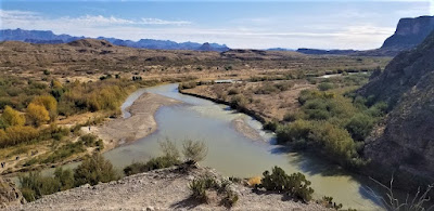
Now we get to the Santa Elena Canyon observation area (GC37ECH). The Santa Elena Canyon is one of the most famous landmarks within Big Bend National Park. Looking from the overlook area, that's the United States on the right, Mexico on the left, and the shallow Rio Grande River flowing up through the middle and curving to the left. A lot of people stop there to get their photos. However if you keep following the road around, it will take you down to the entrance, or should I say the exit.


Where the Rio Grande exits the canyon, there's the Santa Elena Canyon Trailhead. The Terlingua Creek drains into the Rio Grande River just as it exits the canyon. You can see it in the next photo coming in from the left. Most of the time the water level is low enough and you can easily walk across rocks without getting wet. Once you cross over and climb the short hill you enter the trailhead that has been paved creating an easy hike with stairs and switchbacks up 160 feet to the point from which I took the photo.


Once you make the short hike up and over at the trailhead, you make your way down the trail into the cool canyon. Because of the 1500 feet canyon walls that seem to raise up forever, they block out the sun except for the short time it is directly overhead. We continued our hike down and back to see how far we could go. Officially it's a 1.5 mile out and back hiking trail.


At this point, we came to the end of the trail. This is about as far as you can hike without getting wet. Now I was wanting a kayak so I could keep going to see what's around the corner. One of these days I just might do that.


Backing up a little ways there's this huge rock that had fallen near the edge of the bank of the Rio Grande. I talked Candy into climbing out on the rock with me and handed my phone to another hiker to take our photo. I think this turned out much better than trying to take a selfie and still get the full canyon effect.


Having made our way back in the GeoJeep, it was time to hit some of the offroad trails. First we drove back up the Ross Maxwell Scenic Drive and looped around over to the Panther Junction Visitors Center. This time we finally bought one of those National Park Passport books that you get stamped each time you visit a national park or historical site.

From there we made our way down to Glenn Springs Road. It's a gravel road that even a regular car can make it through, see the first pic at the top of the blog. There might be some parts that may be a little rough, but I'd drive down most of it if I still had the Prius and the turn around if I got to an impassible section.

After several miles it turns into Black Gap Road as it nears the spring. There it does become a rougher section that really requires high clearance vehicle. Just past the Glenn Spring primitive campsite I found my next virtual geocache (GCR2A8). The U.S. Calvary once used this location for a few years. If you look hard enough you can still find parts of the foundations of some of the buildings. At the top of the nearby hill you'll find some scattered wooden crosses for the cemetery. To get credit for finding the virtual cache you need to email the number of crosses. The Find-A-Grave website only lists five memorials here. If you use that number you won't have the correct number as there are more than that. And not having any names on the wooden crosses, they are known only to God.


Another hour or so of offroad fun in the GeoJeep and we make our way to the exit roads and back up to Alpine, Texas. It wasn't until later that I realized the Black Gap Road was one of the trails in the Jeep Badge of Honor series. If I had used the BoH app to check in from the trail, I could have gotten my first badge. Oh well, I guess that's a good excuse to have to come back and explore some more of the Big Bend National Park. There is still much to see out here that I haven't gotten to yet. And I recommend this place to be put on your bucket list one day. Just try to avoid summer as the temps are easily in the triple digits!

To follow along on our travels and keep up with my latest blogs, you may do so here of course. But also by using you favorite of these social media platforms: FacebookMeWeGabRedditParlorTwitter, and Instagram. These all link directly to my profile. Again, please feel free to comment and / or share.

Saturday, August 14, 2021

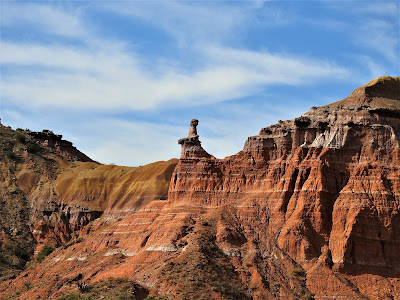
2019-11-25: Our Return to Hiking the Lighthouse Trail in Palo Duro Canyon Texas

Welcome back friends, family, geocachers, RV'ers, Jeepers, and everyone else who just happened to drop by my AwayWeGo's Geocaching Adventures blog. This is more about just geocaching though. I'm here to share my travels around this great country. The geocaching just helps me find some of those out-of-the-way very rural backroads "not-on-your-tourist-map" great sightseeing treasures.

If you'd like to follow along via many of the social media sites. I'll provide links at the end of this blog. I'd also love to hear from you, so please feel free to comment here or on the social sites. And please by all means share my stories with your friends too. I hope my stories inspire you to get out and explore.


Well after my opening paragraph, today we DID do the touristy thing and return to the Palo Duro Canyon. We both had this Thanksgiving week off so we decided to take a drive up to Amarillo, Texas and do some hiking in the Canyon. We were here a few years earlier to make this hike and that's where I proposed to her. (see "She Said Yes!") We've been married now for just over three years.

Plus along the hiking trail up to the famous rock formation called The Lighthouse, there was a trail of geocaches hidden. Many of those caches had been missing and we had to DNF them. They've since been replaced and now we can redeem those DNF's.


The weather couldn't have been better! It was cool out and with sunny skies, it made for perfect hiking. It also made for some pretty good photos I think. This next photo I call Sitting Chief. I don't know if it has an official name, but that's what I think of every time I see it.


Some background info from the Palo Duro website: The history of the canyon goes back a long ways. The Clovis and Folsom peoples first lived in the canyon and hunted large herds of mammoths and giant bison. More recently, the Apache, Comanche, and Kiowa took advantage of the canyon's plentiful resources. These early cultures left behind rock art and bedrock mortars where they ground mesquite beans and roots for food. The early Spanish explorers probably discovered the canyon and called it Palo Duro, Spanish for Hard Wood.

The Red River War between the U.S. Army and southern Plains Indians lasted from June 1874 to the spring of 1875. A decisive battle occurred in the canyon on Sept. 28, 1874. Colonel Ranald S. Mackenzie led the 4th U.S. Cavalry in a surprise attack at dawn on a camp of Comanches, Kiowas and Cheyennes. The families fled up the canyon, leaving everything behind. MacKenzie’s troops captured 1,400 ponies and shot most of them. Soldiers also burned all the teepees and winter stores. With no horses or supplies, the families had no choice but to return to the reservation. The reign of Native Americans over the Panhandle plains ended soon after.


Charles Goodnight, a former Texas Ranger, drove 1,600 Longhorn cattle to Palo Duro Canyon in 1876. He and his partner John Adair, an English aristocrat, founded the JA Ranch in 1877. At its peak in 1885, the ranch grazed 100,000 head of cattle on 1,325,000 acres spread across the Panhandle. After Adair died, his widow, Cornelia, took over as Goodnight’s partner. In 1887, Goodnight decided to scale back his ranching activities. The partnership ended that year, and the partners divided the land. Most of the canyon belonged to the JA Ranch up until 1890. Adair descendants continue to run the JA Ranch today.

The state bought the land for the park from Fred S. Emory in 1933. Soon after, Civilian Conservation Corps workers arrived, and spent the next five years creating a park. First, they built a camp for their home base, and then they set to work in the immense canyon. The men built the winding road to the canyon floor. Until it was finished, they hiked in and out of the canyon on what is now the CCC Trail. CCC workers made all of the park’s original improvements, including El Coronado Lodge (now the Visitor Center), the cabins on the rim and canyon floor, and trails. Designers planned the park to maximize views and complement the surroundings. The CCC used local stone and wood for building materials. In addition, workers forged decorative metal and crafted furniture. The park opened in 1934 before it was complete. It is the second largest park in the state parks system today, with about 28,000 acres


So of the 6 or 8 remaining caches along the trail that we needed to find, we only DNF'd just one... again. Since our last visit there was added a virtual geocache (GC7B6H7) and an earthcache (GC81YE8) up at Lighthouse Point. Upon arriving, we did the obligatory oohs and aahs, took in the views and captured some photos. Then after a short time we hunted for the answers for the caches before descending down into the canyon for our hike back to the parking lot. It is a beautiful Texas State Park and one of my favorite places in the country. I'm sure we will be returning again often.


I hope you have enjoyed our visit today to Palo Duro Canyon up in the panhandle of Texas. To follow along on our travels and keep up with my latest blogs, you may do so here of course. But also by using you favorite of these social media platforms: Facebook, MeWe, Gab, Reddit, Parlor, Twitter, and Instagram. These all link directly to my profile. Again, please feel free to comment and / or share. Until next time... see you out on the road!

Saturday, January 9, 2021

2019-04-20: Geocaching, Hiking, and Exploring the Beautiful Wichita Mountains Wildlife Refuge in Oklahoma

For today's adventure, we are once again Away-WE-Go for this Easter holiday weekend. Most of these blog posts I'm usually by myself on my Sunday drive back to work. Having this long weekend off, we decided to take a drive up to Oklahoma.


If you recall last month on my long roadtrip back from Minnesota, I had stopped at the Wichita Mountains Wildlife Refuge. I mentioned that they perform a live Passion Play every Easter and have been doing it for nearly 80 years. You can read more about that by revisiting my blog page here. Candy and I thought it would be a great idea to go and see it. So we drove up yesterday.

The granite walls of the Wichita Mountains offered refuge to waves of people over many centuries, beginning with Nomadic Native Americans. In the late 1800's, conservationists made plans to re-establish bison and other imperiled species in the region. Looking for the best habitat, they decided that the sheltered prairie of the Wichita Mountains was the ideal location.

This morning we came here to see more of the natural refuge, do some hiking, and hopefully see some wildlife. For our first stop we drove over to French Lake and parked by the Bison Trail for a hike over to the dam. The many dams located in this refuge which form all the lakes were constructed in the 1930's as park of the Federal Work Projects. We hiked the Elk Trail back to the GeoJeep. It was a pleasant, clear, perfect weather morning. Got some nice views of the lake and the dam. The only wildlife we saw was a bunch of turtles and some fish in the lake.


From there we drove south on Indiahoma Road down to our first geocache. The "Heart Rock Earthcache" (GC3AQ2J) is a large outcrop of lava rock forced up from below the surface. Many, many years of erosion created this heart shaped rock on a pedestal that's about chest high when standing next to it. If it wasn't at such an angle, it'd make a great picnic table. While there is a pull-off parking area for the scenic views, there's no mention of this heart rock formation. Just another reason why I like geocaching to find the unique roadside attractions.


Just as we got back to the GeoJeep, we were just in time to see a parade of more than a dozen old tractors going by. Now I'm not really into tractors but seeing some antique machinery being driven down the road was pretty cool.


Back up on State Road 49 through the middle of the Refuge, we come upon Prairie Dog Town. A field of hundreds of prairie dogs running around and popping up and down from their underground city. I wish I had my Nikon camera with me but I left it back in Texas. So I only have this fuzzy phone photo. Takes good pics normally, but not so good when you zoom in close.


Next we drive over to the southside of Quanah Parker Lake to the Little Baldy Trailhead. Crossing the Quanah Creek Dam which forms the lake, we begin hiking the Little Baldy Trail. Little Baldy is one of the rocky hills within the refuge. We hiked up to the top of for the views and for the Little Baldy virtual geocache (GC1E4D).


Returning to the GeoJeep and continuing down the road a few miles we finally saw some bison. So we pulled over, took some photos, and watched for a while.


It was now mid-afternoon and we didn't plan very well. We're now out of water and hungry because we didn't think about bringing snacks or food. We stopped by the Holy City of the Wichitas for a quick look to see what of the situation. People were already gathering and picking out their spots to watch the Passion Play which was still 10 hours away from starting. Candy got a quick look around at the buildings. They had bottled water but nothing to eat. So we needed to go back into Lawton to eat and return later.

As we were driving out we stopped at this structure. Completed in 1927, Benjamin Ferguson and his family lived in this house until 1942. About a half mile to the east is the Ingram Homestead. They were both built out of the round granite core stones that cover the hillsides of the refuge, and both were acquired during the 1901 land lottery held at Fort Sill. They reflect the hard work, ingenuity, and craftmanship of earlier generations.

In 1942, the U.S. Army used the right of eminent domain to acquire the homesteads to expand the artillery range of the adjacent Fort Sill. Fifteen years later the planned expansion was scrapped and the homesteads became a part of the Refuge. In 1981 they were added to the National Register of Historic Places.


After grabbing some dinner and now back at the hotel to freshen up after all the hiking today, we were too exhausted to drive back to the Refuge to sit and wait for the play to start. But now that we have a better understanding of what it would be like, we're better prepared to come back again. Though next time we'll have folding chairs, a cooler with drinks, and plenty of food.

Still a great day of hiking and exploring the Wichita Mountains Wildlife Refuge. Come back tomorrow for the roadtrip home. I've got a few interesting places on the agenda for the roadtrip home. See you then...