Showing posts with label state park. Show all posts

Saturday, June 4, 2022

2020-11-22: Geocaching and Sightseeing in Houston, Texas and a Visit to Howard Hughes

Welcome back fellow RV'ers, Jeepers, Geocachers, and travelers. Having a day off from the jobsite, we decided not to hand around the campground but go off on another little roadtrip adventure. Now of ALL the places I've been to, having visited 49 states, from big cities to ghost towns, my two least favorite cities have been Atlanta and Houston. 

Well today we're taking a drive up to Houston, Texas to see if it can redeem itself. Mostly because there's a HUGE cemetery there that I want to go see which happens to have a geocache at the final resting place of Howard Hughes. So climb aboard the GeoJeep and let's go for a drive.  


Arriving in Houston, we stopped for a quick drive by virtual geocache (GC73BD). "The Dancers" virtual geocache would have been cute. But some people are just taking this whole mask wearing thing to the extreme. These topiary bears would look fun, but do you really need to put masks on plants? 


Our next stop was at Hermann Park. This is a huge park near the center of Houston with all sorts of things to see and do. There's the Miller Outdoor Theater (GC5W8YR), the Houston Zoo (GC84FF), a golf course, a Japanese Garden, the Museum of Natural Science, and a small train that runs throughout the park.


Also located within Hermann Park was this large reflection pool. The Mary Gibbs and Jesse H. Jones Reflection Pool is about half the size as the reflection pool at the National Mall in DC at 740 feet long and 80 feet wide. At the north end is this huge statue of Sam Houston, the city's namesake.


Samuel Houston (March 2, 1793 - July 26, 1863) (GC5X8PB) played a major role in the Texas Revolution and became the first President of the Republic of Texas. After serving a second term as the third Texas President, he went on to be one of the first two individuals to represent Texas in the United States Senate after statehood.


Within a few blocks of Hermann Park were two more virtual geocaches. The first was at the Children's Museum of Houston (GC8576). The other was at the Holocaust Museum of Houston, pictured below (GC8501). On March 3, 1996, just 13 years after Siegi Izakson first dreamed of the idea, Holocaust Museum Houston was officially opened for admission with Izakson proclaiming, “This means the Holocaust story will not go away.”

After a $34 million expansion, the Museum reopened in June 2019 after more than doubling in size to a total of 57,000 square feet. Ranked as the nation's fourth largest Holocaust museum, the new three-story structure houses a welcome center, four permanent galleries and two changing exhibition galleries, classrooms, research library, café, 187-seat indoor theater and 175-seat outdoor amphitheater. With more than 50 screens, mini-theaters and interactive terminals are featured throughout the Museum.


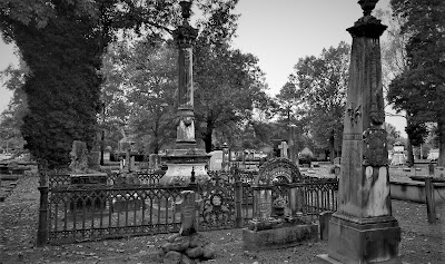
Finally arriving in Glenwood Cemetery, we're ready to grab some geocaches (GC8M3QH, GCTNRF, GC5CXCW, GC8M3QC) and take a walk through Houston's history. Glenwood Cemetery was established as a private cemetery in 1871 by the Houston Cemetery Company, which was incorporated by an act of the Twelfth Legislature of the State of Texas on May 12, 1871. After construction, Glenwood opened for business in the summer of 1872.

The gravesite on my bucket list was that of Howard Robard Hughes Jr (GCGZFY). Born December 24, 1905, Howard Hughes was the Elon Musk of the mid-1900's. He was an American business magnate, investor, record-setting pilot, engineer, film director, and philanthropist, known during his lifetime as one of the most influential and financially successful individuals in the world. He first became prominent as a film producer, and then as an important figure in the aviation industry.


Later in life, he became known for his eccentric behavior and reclusive lifestyle—oddities that were caused in part by his worsening obsessive-compulsive disorder (OCD), chronic pain from a near-fatal plane crash, and increasing deafness. He died of kidney failure on April 5, 1976 and is buried here with his parents at Glenwood Cemetery.


The Priester family plot contains the burials of six family members starting in 1906.


One of the many garden like settings within Glenwood Cemetery.


The Crump family plot is a little more cheerful, though I'm not sure if the girl statue is a part of it. The large dog with a bird on it's head is. The plot contains 34 year old Jason Crump, who passed away in 2006, and his father 79 year old James Crump who passed away in 2019.


Throughout Glenwood Cemetery are these beautiful huge oak trees. They kinda make you want to go climbing.


There are many other notable famous people that permanently reside within the cemetery. If you have a moment, visit the Find-A-Grave website for a list of some of them. Such as J.S. Cullinan, the founder of Texaco. Or how about Rienzi Melville Johnston who, at the age of 12, enlisted in the Confederate Army in 1961 and served as a drummer. Thomas Saltus Lubbock Sr., a Confederate Army officer and namesake for the city and county of Lubbock. And actress Gene Tierney.

Across the Buffalo Bayou and a few blocks away was our last geocaching stop at the Founders Memorial Cemetery (GC4TEJE). There are 139 interments dating back to 1836 and all but seven are pre-1900. Here you'll find many participants in the war for Texas independence and the United States Civil War. Check out the entire list at Find-A-Grave.


The one that I wanted to highlight the most was for John Kirby Allen, co-founder of the city of Houston. In 1836, the area of Buffalo Bayou was a humid swamp overgrown with sweet gum trees and coffee bean weeds. In this spot, two brothers from New York recognized the future commercial hotspot of Texas.

John Kirby Allen was born in Orrville, New York, in 1810. Along with his older brother, Augustus Chapman Allen, a professor in mathematics, the two moved to Texas in 1832. John Allen was an astute businessman and natural leader. At the beginning of the Texas Revolution, the Allen brothers did not enlist in the militia but instead worked on supplying and arming the troops, often at their own expense or at cost. He and his brother soon saw the area around Buffalo Bayou could readily become a major seaport. Immediately after the Battle of San Jacinto, the Allen Brothers carefully chose the site of future Houston.


On August 24 and 26, the brothers paid $9,428 for 6,642 acres of land originally granted by Mexico to John Austin, a pioneer colonist. He and his brother ran advertisements in Texas newspapers proposing a new townsite called Houston, a name that Augustus' wife Charlotte had come up with in order to capitalize on the popularity of Sam Houston. 

John Allen continued with his businesses as well as city planning, running a partnership in a shipping business with future first governor of Texas James Pinckney Henderson. Dedicating his short life to building the city he and his brother built from nothing, Allen never married. He died of congestive fever on August 15, 1838, and was buried in Founders Memorial Park, Houston, at the age of 28.

Augustus Allen eventually moved to Mexico in the 1840's. There he served as U.S. Consul for the ports of Tehauntepec and Minotitlan and was engaged in various business enterprises. In 1863, Augustus traveled to Washington, D.C., where he contracted pneumonia. He died there at the Willard Hotel on January 11, 1864. Unable to have his body returned to Houston, his widow Charlotte had him buried in Greenwood Cemetery, in Brooklyn, New York. 

That's it for our tour of Houston history. It has improved on my opinion about Houston, though slightly. We went and found ourselves a nice Greek restaurant before heading back to the RV park in West Columbia. I hope you enjoyed todays adventure.

To follow along on our travels and keep up with my latest blogs, you may do so here of course. But also by using your favorite of these social media platforms: FacebookMeWeGabRedditParlorTwitterRVillageGETTRInstagram, and TruthSocial. These all link directly to my profiles. Again, please feel free to comment and / or share.

Saturday, April 2, 2022

2020-10-19: Westbound Roadtrip Through Tennessee Civil War History and a Walking Tall Sheriff

Here we are on Day #2 of our westbound roadtrip. Today's trip took us from the Civil War history in Chattanooga through the backroads along the southern route of Tennessee towards Memphis. There's a lot of sightseeing to do, a lot of new geocaches to find, and new counties to add to my map. So climb aboard and let's go for a drive...


With its railroads and riverboats, the city of Chattanooga was a vital transportation center during the Civil War. Both armies recognized its importance. In the late summer and fall of 1863, several key military actions decided the fate of Chattanooga, and helped determine the fate of the Confederacy.

September 18-20: About 10 miles south of Chattanooga near West Chickamauga Creek, Confederate forces defeated the Union Army in a bloody two-day battle. The Federals withdrew to Chattanooga and fortified the city.


September 22 - November 23: Confederates laid siege to the city of Chattanooga to force the Federals to surrender. Confederates occupied positions along the Tennessee River, Missionary Ridge, and Lookout Mountain. In late October, the besieged and hungry Federals managed to open a supply line through Lookout Valley into the city. With fresh troops and supplies, they were ready to fight by late November. On November 23rd, Union troops stormed and captured Orchard Knob, a hill to the east of their defense line in the city.


November 24: Union forces drove the Confederates from their position on Lookout Mountain. Because the mountain was partially shrouded by fog, the action was also called the "Battle Above the Clouds." The following day, Union forces stormed and shattered Confederate unites occupying Missionary Ridge. The siege was broken and Chattanooga became the Federal base from which Maj General William T Sherman would launch his Atlanta campaign in the spring of 1864.


Point Park preserves strategic high ground captured by Union soldiers during the Battle of Lookout Mountain in 1863. Today it is part of Chickamauga and Chattanooga National Military Park and the location of our first virtual geocache (GC41C9). The New York Peace Monument, the centerpiece of the park, symbolizes the reconciliation of the North and South.


Driving down off Lookout Mountain, I made a stop near the base of the Incline Railway for our next virtual geocache (GCMFYC). The Incline Railway up historic Lookout Mountain is the world's steepest passenger railway. The first Incline up Lookout Mountain opened in 1887. It ran from the 38th Street area in St. Elmo to just below the Point. The second Incline, engineered by John Crass, opened November 16, 1895, and is the Incline that is still in operation today. The success of the second Incline was the primary reason that the first Incline closed in 1899.

The incline, 1,972 feet long and rising 1,450 feet, is superbly designed to suit its location. It makes use of a variable grade, ranging up to 72.7 percent near the top, to compensate for the changing weight of the cables as its cars move. One of the cars has flanges on the inside of its wheels, the other on the outside, allowing the cars to pass midway with no moving parts in the track turnouts. Both cars have self-contained emergency brakes. Originally powered by steam, the incline now is driven by two 100-horsepower motors. The latest evolution of the incline cars were just recently installed in March 2020.


Robert Craven built the first house on the hillside of Lookout Mountain in 1856. Seven years later, the Confederate Army occupied Lookout Mountain and Craven's house became the headquarters of Brig. Gen. Edward C. Walthall. On November 24, 1863, Union troops stormed the mountain and pushed the Confederates around to the north end.


When Robert Craven returned to his home after the battle, he found little of his home standing except the basement, the chimney, and the stone dairy. In addition to artillery damage, soldiers had stripped the house looking for souvenirs and firewood. The Cravens rebuilt the house as it currently stands.


Many of the Civil War Battlegrounds have monuments scattered throughout placed by the various states as a memorial to those soldiers who fought and died while representing their states. This particular memorial statue was honoring those soldiers from the state of New York. There is another monument nearby from Illinois which also happens to be a virtual geocache (GC621C).


Finally leaving Chattanooga and Lookout Mountain to continue our roadtrip westbound, we enter the town of Winchester in Franklin County. The town was named after James Winchester (1752 - 1826), who was a soldier in the American Revolution, Speaker of the First Tennessee Legislature, and Brigadier General in the War of 1812. The town of Winchester was created as the Franklin County seat on November 22, 1809.

One of the many monuments and historical markers located within the town square was this one dedicated to the memory of Colonel James Lewis (1756 - 1849). It is also another virtual geocache (GC9366). Col. Lewis served with distinction in the Revolutionary War. He participated in the battles of White Plains, Trenton, Princeton, Brandywine, Germantown, and Yorktown. He erected the first brick house in town and was one of the appointed commissioners for the erection of the first courthouse and jail in Franklin County. There are two other historical accomplishments, but that would give away the answer to the virtual geocache.


The one building that caught my eye the most was the Oldham Theater. Apothecary and druggist shops were originally on this corner from the 1820's thru 1900 with doctors offices upstairs during the 1880's. Later the street level housed the Franklin Grocery and Bakery until the 1930's. The spacious upstairs was hosted large civic gatherings and parties while leased by the Business and Professional Women's Club. The old building was razed in 1949 for construction of a theater.

George E. Oldham, who owned the Rivoli Theatre on the south side of the square, bought this theater from his brother-in-law in 1949 while it was still under construction on the north side of the square as a replacement for his older theater. Unfortunately, George Oldham passed away in September 1949 before the theater officially opened a year later on September 14, 1950 and named in his honor.

Though virtually unchanged in appearance, ownership changed several times and a major renovation began in 2009 and took three years to complete. The upgrade to the two-screen theater included incorporating digital projection equipment, installing surround sound, new curtains and new seats. I think it's pretty cool to see these old theaters still in use.


Continuing our drive west on US-64, the next Tennessee county needed for our geocaching map was Giles County. We stopped in the town of Pulaski at this unique and historical cemetery and memorial park (GC5BQW0). The first cemetery in Pulaski was on the outskirts (at that time) of town in 1817, in a field where interments continued until 1883 when all of the lots were full. Over the years abandoned and nearly forgotten, the cemetery fell into disrepair.

Until in 1969, Pulaski began an urban beautification project here to transform the old cemetery into a city park. The overgrowth was cleared out and headstones were located, identified and cleaned. The headstones were then mounted; the smaller ones in curved structures on the ground and the larger ones into a stone wall along the back of the park. A few monument markers that were still standing after the years were left where they were. Finally, landscaping, paved paths and lighting were added. The interred remains were left in their original locations as it could not be determined who was where except for the few monuments that were still standing.


Moving on into Lawrence County and the town of Lawrenceburg, we find our next two geocaches and a look back into Tennessee history. First was the Garner Mill Earthcache (GC1PPNT). The Garner Mill was used extensively from 1825 to 1849. It was built in 1820, and functioned as a grist mill initially, and then was converted to a water powered sawmill in 1851. Both the dam and the mill were destroyed in the flood of July 13, 1998. The ruins of the foundation still survived the flood, as well as the footings for the dam on the far side of the river. It is listed on the National Registry of Historic Places.


Closer to the center of town was our next geocache at the home of Davy Crockett (GC6K21P). David Crockett lived in this cabin from 1816 to 1822. He was one of the commissioners who laid out the county and selected the site of Lawrenceburg, a colonel in the militia, Justice of the Peace, member of the legislature, and operator of several industries on Shoal Creek during his residence here.


In the Lawrenceburg town square is a statue of Col. Davy Crockett. Born in East Tennessee on August 17, 1786, he gave his life for Texas Liberty and Independence at the Alamo that fateful Sunday morning on March 8, 1836.


Still heading westbound on US-64 picking up new geocaching counties, I make a quick roadside stop for a geocache in Wayne County (GC6B2WF). It was a good thing I stopped for the easy geocache because my target cache was a DNF (GC69K7B). But the good thing is that you never know what you're gonna see while geocaching. Like this homemade rocket ship trike!


Next up was Hardin County in the town of Savanna along the banks of the Tennessee River. There once was a house here built by James Rudd, a pioneer ferry operator, long before the US-64 highway was crossing the river. That house was replaced by another built by David Robinson, whose son-in-law William H. Cherry, improved and enlarged it. During the Civil War, "Cherry Mansion" became the headquarters for Federal Army commander Major General C. F. Smith. When he died he was succeeded by Major General Ulysses S. Grant. Maj. Gen. Wallace died here after being mortally wounded at Shilo.


Unfortunately the geocache had gone missing and I had to DNF it (GC2TVN9). Still needing the county, I stopped a couple blocks away at this small park memorializing the Battle of Shiloh where I found the geocache hidden here (GC1F8PZ).


Just a short drive over to McNair County, and we stop for our next geocache (GC5T5DM) highlighting a local hero and nationally known figure. The movie "Walking Tall" made Sheriff Buford Hayes Pusser a household name. He was born near Finger, Tennessee on December 12, 1937, raised here and graduated from Adamsville High School in 1956. About a year later, Buford moved to Chicago where he worked as a die cutter, attended Worsham College, and wrestled professionally on weekends. While in college he met and married Pauline Mullens.


The saga of Bufford Pusser and the illegal activities on the Tennessee-Mississippi state line began early in 1957, when he was beaten severely at a club in that area. In January 1960, he was arrested for assaulting the owner of a club on the Mississippi side of the3 state line. Bufford received a verdict of innocent at a trial held in Corinth, MS.

Buford's career in law enforcement began when he was appointed Chief-of-Police of Adamsville in 1962. He was later elected Constable and then Sheriff of McNairy County, serving three terms. During his first year as Sheriff, Buford was stabbed on several occasions and along with his deputies raided over forty-two moonshine operations. In 1966 he was forced to shoot in self-defense the operator of a motel on the state line where he had gone to investigate a robbery. In January of 1967, Buford was shot at point blank range four times by two men he had stopped in the state line area. The most deplorable episode in his career began one early morning on August 12, 1967 when he, accompanied by his wife, was enroute to answer a call. They were ambushed on New Hope Road, killing Pauline with Buford barely surviving the ordeal being severely wounded himself. In December 1968, Buford answered a call for help and a known murderer opened fire on him, leaving him no choice but to shoot and kill him in self-defense.


Sheriff Buford was selected in 1970, by the Jaycees, as one of Tennessee's "Outstanding Young Men of the Year." He had signed a movie contract to depict himself in a sequel to the movie "Walking Tall" when he was suddenly killed in an automobile accident on Highway 64, west of Adamsville, on August 24, 1974.

Bufford Pusser's experiences have inspired seven movies, five books, a television series, several magazine articles, and a Colt Commemorative Limited Edition handgun, all depicting the life of a man who "Walked Tall."


Our last geocaching county of the day is for Hardeman County and the town of Bolivar, Tennessee. It was a quick park and grab geocache to claim a find in the county (GC4WGKP).

From there it was just a couple of blocks south to the Polk Cemetery. Even though there's wasn't a geocache there, it was historical and worthy of a stop. The land was acquired by James K. Polk Jr. and others on October 23, 1845 as a family cemetery for the descendants of Ezekial Polk. Colonel Polk, the patriarch of the Polk family in Tennessee, was the grandfather of President James Knox Polk. The elder Polk was instrumental in framing the Mecklenburg Declaration of Independence and served in the Revolutionary War. He lived in Maury County before settling in Hardeman County.


That's all for today. We continue heading west on US-64 and find a place to stay for the night just outside of Memphis. I'm thinking a trip to Elvis's Graceland in the morning might be a plan. I hope you return to see the outcome. Until then...

To follow along on our travels and keep up with my latest blogs, you may do so here of course. But also by using you favorite of these social media platforms: FacebookMeWeGabRedditParlorTwitterRVillageGETTR and Instagram. These all link directly to my profile. Again, please feel free to comment and / or share.

Wednesday, May 31, 2017

2017-05-27: Geocaching Through Old Historic Texas Towns, a Cemetery, Churches, and More!

Hello again and welcome back to the AwayWeGo's Geocaching Adventure Blog. Before I get started, I just wanted to say thank you for stopping by and following along with our travels. We hope they have not only been entertaining, but informative and making you want to get out exploring and Geocaching yourself. Always feel free to share this blog with your friends and please leave your comments below. We'd love to hear from you.

Today's Geocaching Adventures took us to North Central Texas. Texas is so large you kinda have to use two directional words to narrow down the area! Kinda in the Abilene to Wichita Falls to Fort Worth triangle if you will. We had 11 unfound geocaching counties on the radar, but managed to make it to only 7 before skipping the rest and heading back to the hotel. A nearly 500 mile loop just to get those! I think we would have tried to get the others, but imagining what the puppies were destroying after 12 hours locked up in the hotel room...!? Yeah better get back!

So this morning we walked and fed the pups and putting the "Do Not Disturb" on the hotel door, don't want housekeeping to be mauled by the 6 lb Chihuahua  and 3 lb Pomeranian attack dogs! We drove over to nearby Denny's for a hearty breakfast and then Starbucks for our coffee on the road. The hotel being in Abilene and Taylor County which we already have, we skipped the local caches.

Driving up US-277 north to Jones County, we arrived in a town called Anson and our first cache. The Anderson Chapel Cemetery (GC1J1X3) is about five miles west of town on US-180. The oldest known burial is from 1896 and that of Bertha C Anderson. Though there are many unknown burials with a cross or a single rock as a headstone among the 94 known internments. I couldn't find much on the history here other than a Hugh Anderson (1846-1922) donated the land for the cemetery and that the chapel had burned down at some point.


Our next cache was located within Anson, the Jones County Seat, at the larger more modern cemetery (GC16B4Q & GC13DQN). With over 6400 headstones, I didn't spend much time "browsing."

Continuing on US-180 eastbound over into Shackelford County, our next stop was the Bud Matthews Switch (GC2PT75). In 1900, the Texas Central Railway extended a line northwest from Albany across this portion of Rose Ella (Matthews) Conrad's cattle ranch. Ella and her brother John A. "Bud" Matthews, for whom this site is named, promptly constructed cattle pens and a loading chute at this location. Surrounding ranchers soon were shipping their cattle from this switch to markets in Fort Worth. As many as 105,000 head of cattle were shipped annually until the railroad ceased operations in 1967. Since that year, local ranchers have continued to load cattle onto trucks from this site.

I didn't find the Geocache here though. There's a lot of hidden pockets and places to hide a micro cache on train cars. Over the years of caching and getting stung by wasps, I've gotten cautious about sticking my hands into places where potential critters can hang out. Especially here in Texas with the addition of scorpions, deadly spiders, and rattle snakes! And having left my gloves in my car, I just gave it a quick looking over.

Then we arrive in Albany, Texas just a few miles to the east. Not necessarily the cache, but the town itself was one of the highlights for the day! There was a lot of history here to see. So let's start from the beginning... William Henry Ledbetter (1833-84), a native of Georgia, came to Texas in 1858 and established a salt works on Hubbard Creek (8 miles southwest) in 1862. Ledbetter withstood fierce Indians attacks before moving near Fort Griffin (15 miles north). He was elected first county judge in 1875. In the mid-1870s, Ledbetter built this picket house near the army post, using construction methods typical of this frontier region. It was moved here and restored by the city of Albany in 1953.

Chosen county seat of Shackelford in 1874, Albany had a 43-acre townsite donated by Sheriff Henry C. Jacobs. County clerk W. R. Cruger named city for his old home, Albany, Ga. A wooden picket courthouse was erected. The post office opened August 1, 1876. By late 1877 there were 16 buildings - homes, hotels, saloons, a blacksmith shop. Merchants were T. E. Jackson and firm of Woody & Hatcher. Physicians W. T. Baird and W. M. Powell and lawyer A. A. Clarke located here. D. H. Meyer and Edgar Rye began (1879) publishing "The Albany Tomahawk". Already on the western cattle trail, city expanded as a frontier shipping point when Houston & Texas Central Railroad built a terminus here in 1881. By 1882 a church building had been erected. Music lovers organized a cornet band. In 1883 an opera hall opened, and a permanent courthouse of native stone was built. Succeeding D. R. Britt as the school principal, W. S. Dalrymple founded an adult study club, "The Chautauqua Literary and Scientific Circle". Albany had an academy, and then a college in 1898-1915. Local activities include ranching, petroleum production, small farming, and annual staging of the historical drama, "The Fort Griffin Fandangle".

Shackelford County Jail Erected 1877-78
T.E. Jackson Warehouse Established 1878
Charles A. Hartfield purchased the lot on this site in 1881. A noted area cook, he quickly established "Charley's Restaurant," which included a bakery and boarding house. Hartfield was so successful that he planned an elegant rock structure in which to house his business. Construction began in March 1884 amid a flurry of development in the area. Scottish stonemason Patrick McDonnell, who was responsible for much of the stonework on the new courthouse, was foreman of the Hartfield worksite. The project's scope proved too grand for Hartfield's finances, however, and in September 1884 he sold the building to J.C Lynch. Financially ruined, Hartfield was found dead within a year.

Lynch sold his building in 1885 to three Albany businessmen; Max Blach, N.H. Burns, and Sam Webb. Charles Hartfield's widow, Lettie Hartfield, joined them as an equal partner and the group completed the structure, probably using Charles Hartfield's original plans. The building was occupied over time by such businesses as a grocery, a gerneral merchandise store, a bowling alley, and an auto repair shop. The Albany Masonic Lodge began meeting in the structure as early as 1893, and it became known as "The Masonic Building" to local residents. Real estate magnet L. H. Hill purchased the building in 1925, and the Masonic Lodge bought it in 1940.

Damage from nesting bats caused part of the building's limestone front to tumble into the street in 1954. The Masons took down the facade and rebuilt it with yellow brick. Sold again in 1996, the building was renovated and its facade was reconstructed to reflect its former grandeur as one of Albany's finest early structures.

Charles Hartfield also purchased this land next door in 1882. As he began construction on the restaurant in 1884, he sold this property to Max Blach, VP of the Albany Water Company. He and partner N. H. Burns brought a system of running water to the town in 1884.

Blach began construction on this one story native stone structure also in March 1884. The building was completed in April and leased to J. R. Davis, who put it to its most infamous use. The White Elephant Saloon opened for business on May 1, 1884. Among its instantly popular features was a white elephant display which was removed from the rooftop early in the establishments heyday.The perpetrators were believed to be citizens who disapproved of the saloon's raucous business.

Despite its popularity, Davis announced his intent to close the saloon in February 1886. The Blach building soon was leased to W. M. Wigley, who operated a dry goods and furniture store on this site. Succeeding furniture businesses occupied the building for many years.

Blach's heirs sold the structure to S. C. Coffee in 1919. Coffee sold it in 1923 to T. J. Crow, who conveyed it to Albany businessman L. H. Hill in 1925. The structure was used for various purposes over the years: it was the home of the Albany News in the 1940's and was the workshop and office of a pipe organ maker in the 1950's and 60's. The Hill family maintained ownership of the edifice until 1977.

The Lynch Building: this was Albany's first stone mercantile store. It was erected in stages, combining Greek Revival and Victorian Italianate designs. In 1878, W. H. Miller built 1-story east unit, and permitted Albany Masonic Lodge to erect a second story. Local rancher J. C. Lynch in 1881 built the 2-story west unit. The "Live and Let Live" drugstore was an early tenant. L. H. Hill and Family owned the property from 1896 through 1974. Clifton Caldwell bought the property and restored it in 1974-75.
Presbyterian Church erected 1898
Ford Model A truck parked in front of classic car museum.
Restored Sinclair gas station
Restored Gulf gas station
After spending an hour walking around looking at the buildings and reading the historical signs, we finally decided to go after a Geocache. There were several in town but after spending too much time already, I just chose one at the volunteer fire department (GC5GDA9) and made the quick find.

Now heading north on US-283 and trying to make up some time, we made a quick cache stop for the "Sorriest Land in the County." (GCP6QE) There's nothing at the location to see, but the story about the land surrounding made it worthwhile.

On April 1, 1897 James H Nail, Sr and WI Cook paid the Holstein Family of Shackelford County, Texas the sum of $49,000 cash in hand for 27 3/4 sections of land (17,760 acres). On Christmas Day of 1899, Mr Nail wanted to buy, Matilda “Dude” Nail Cook and W.I. Cook, out. After heated discussions, the Cook’s ended by buying out Mr Nail. Angry at his sister for not selling out to him, Mr Nail boasted to everyone, “I’ve just sold Dude the sorriest piece of land in Shackelford County and she’ll be broke in a year, you can bet on it!”

As it turned out, the decision of Matilda Nail Cook not to sell out to her brother was either the wisest or the luckiest decision she ever made because in 1926 the Cook Oil Field was discovered on the southern part of the ranch. For a long period of time, the Cook Oil Field was the largest shallow oil field in the world. 79 Years later, the Cook Oil Field is still producing oil and new wells are still being successfully drilled. The discovery well was, in fact, the last roll of the dice that a group of men would make before going completely broke. As they were hauling their rig to the selected sight, it broke down. The rig could go no further unless additional money was raised for repairs. At this point, they made a field decision to drill on the spot where the rig broke down and hit a gusher!

There's more on the cache page about the Cook's supporting a children's hospital in Fort Worth, but I'll let you click the link for more information.

Further up the road was our next Geocache at Fort Griffin State Park (GC3C5PP). Again, there were several caches here but we only had time for one. In the 19th century, the U.S. government established forts along Texas' frontier to protect pioneers. By the early 1850s, Col. Jesse Stem farmed along the Clear Fork of the Brazos River, and Thomas Lambshead established his Clear Fork Farm. As others moved to the area, troops at Camp Cooper in present-day Throckmorton County, including then-Lt. Col. Robert E. Lee, provided military defense. Camp Cooper closed at the start of the Civil War in 1861.

After the war, the U.S. Army established Camp Wilson, later renamed Fort Griffin, near this site in 1867. Fort Griffin sat on the high ground above the river. A settlement developed between it and the water's edge. The town, known also as "The Flat," included merchants, cattlemen and their families. Its permanent populace supported a newspaper, the Fort Griffin Echo, as well as an academy, Masonic lodge and several stores and saloons. A rough element of cowboys, gamblers and renegades mixed with black and white troops to form a lawless scene. Among those attracted to the town were Doc Holliday, Wyatt Earp, Lottie Deno, Big Nose Kate, Hurricane Bill and Hurricane Minnie.

Unfortunately there was much more here to see, but we had many miles yet ahead of us. And an unexpected phone call was needed and even Verizon had spotty service way out here. So we needed to move on up the road. But we will be back to check out the rest of this now considered ghost town.


The next county on the list and our next two caches (GC13F33 & GC3VY6D) are located in Throckmorton County. The Texas legislature created Throckmorton County - named for pioneer doctor William E. Throckmorton - in 1858, with organization delayed until 1879. F.E. Conrad donated land for the town square and built a frame courthouse on this site. The firm of Martin, Byrne and Johnston designed this 1890-93 courthouse built by J.L. DeWees and Jacob Rath. The two-story Italianate-style building features polychromatic walls of quarried sandstone, quoins, pilasters, horizontal bands, arched doors and windows and a Mansard roof with brackets, pediments and a square cupola. A matching annex was built in 1938.


Throckmorton County Jail
The next county and our next cache was also one of my favorite things about Geocaching. Located in the south-west corner of Baylor County lies what little remains of the ghost town of Bomarton, Texas. This once-prosperous town was named for settler W. H. Bomar. Things got off to a promising start with the arrival of the Wichita Valley Railroad in 1906. Bomarton was now connected to both Seymour and Abilene. A post office in the store of Tom McClure was established the same year. By 1910 Bomarton had had a school for three years and two churches that were constructed about the same time. Two cotton gins were soon added to the town's list of businesses and Bomarton had an innovative public grazing area dairy cattle. From a population of 580 in 1920, Bomarton reached its high-water mark in 1930 with 600 Bomartonites. The town sailed through the Great Depression with a decline of only 2 people. But the town wasn't so lucky after WWII when it dropped dramatically. By 1960 it was already down to 150 and twenty years later there were only 27 people calling the place home. The 1990 figure was given as 23 and was used again on the 2004 map.

The St. John Catholic Church (GC10WK6) of Bomarton was established in 1908, when services and masses were held in Mary's Creek Schoolhouse or in the home of Matt Marak. The first church edifice was built in 1909, with John Cocek, Matt Marak, Leopold Skrehot, and Alois Sykora, trustees. Father Paul Mosler was installed as the first pastor in 1910. The brick building you see here was built in 1936 and is one of the few remaining buildings.


One more quick cache (GC2F6NX) behind a BBQ restaurant in Seymour, Texas, then off to our next county.

Arriving in Foard County and the town of Crowell, we head to the cemetery for three quick caches: GC6V1X8GC3WH0V, and GC2FJH0. The last was rather creative as it consisted of 5 Geocaching containers inside one another until you got to the smallest at the center which contained the log sheet to sign.

From there we drove quickly east on US-70 over into Wilbarger County and another cemetery cache (GC54W3P). Upon arriving, there was a funeral service just finishing up and so we waited at the entry gate as cars were exiting. Finally we caught a break and was able to enter taking one of the paths in that wasn't being used by those leaving. We circled around to GZ which was about 100 yards from were the service was. Moments later the cache was in hand and we were on our way.

Our next county was Archer to the south-east. Driving down US-287, I should have turned south onto TX-25. However I decided to go the long wide turn south, going into Wichita Falls before heading into Archer County. At this point we both needed another Starbucks. It was either add another 20 minutes to our route and get one now, or wait the 3 hours until we make it back to Abilene!

With fresh coffee in hand, we headed down to Archer City for our final cache (GC431MW) and final county for the day. The cache was hidden at the former Archer County Jail, now a museum. By 1909 Archer County had outgrown its original jail, a 16-foot square frame building. Construction on this larger facility was completed in September 1910. The sandstone structure was designed with living quarters for the sheriff and his family on the ground floor. The second and third floors had cells and a hanging gallows which was never used. The first prisoner held in this jail was arrested for stealing a horse. More than 8,000 prisoners were jailed here until the county opened a new facility in 1974.

With a long drive still ahead of us and thinking of the Geo-Puppies locked up in the hotel room for 12 hours, we skipped the last three counties and headed straight back to Abilene. Looking at the map later I saw we could have gotten one more along the way. But the caches and the route I had planned took us further east and we were driving to the southwest. We actually drove through the northwest corner of Young County and past by two caches. Oh well. It just means we'll be back another day!

Thanks for stopping by and until next time... Happy Caching!