Showing posts with label Tennessee. Show all posts

Saturday, April 30, 2022

2020-10-20: Forget Graceland, We're Going to the Grotto! From Memphis and Geocaching Across Arkansas Counties

Welcome back everyone. This was Day #3 of our roadtrip from North Carolina to Texas. Last night we ended the day just outside and east of Memphis, Tennessee. And what is the first thing you do in Memphis? Forget Graceland. We going to The Grotto!! Not widely known but something that you must see if you're ever in the area. But until then, come with us for a virtual tour of this nearly 100 year old creation.


The plan was to start the day visiting Elvis's Graceland. But when we arrived at the entrance there were signs everywhere about masks being required. While I've been here before, Candy has not. Plus neither one of us are Elvis fanatics. It's just one of those places that you at least have to visit once in your life. However we just weren't up for touring this house during a "pandemic" wearing these silly masks. Which was a good thing because "Plan B" turned out to be a much better choice!


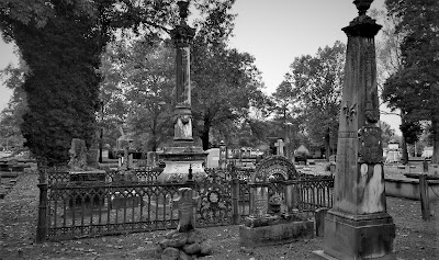
The Crystal Shrine Grotto is located in the Memphis Memorial Park and is also the coolest cemetery cache I've ever found! (GC9CBBIn 1924, E. Clovis Hinds purchased 160 acres of land on the outskirts of Memphis and transformed it into a tranquil graveyard he would call Memorial Park. A cemetery brochure describes his dream: “He sought not merely a pleasant, peaceful place of repose but an atmosphere steeped in tradition, linking the ancient past with the eternal future.”


Dionicio Rodriguez was born outside Mexico City in 1890 and immigrated to the United States in the early 1920's. He perfected a technique for chemically tinting concrete and then carving or molding it into naturalistic forms that closely resembled stones, logs, tree branches, down to such details as artificial worm holes, cracks in the wood, and peeling bark.  Rodriguez met Hinds here in 1925 and under Clovis’ guidance began the construction of what many would consider his masterpiece — the Crystal Shrine Grotto.


Words and pictures don’t really do it justice; only a personal visit shows the full scope of this endeavor. Using tons of tinted concrete, Rodriguez recreated scenes from the Bible and ancient literature. The Cave of Machpelah overlooks the scenic Pool of Hebron. Nearby are Abraham’s Oak, the Ferdinand IV Sunken Garden, Annie’s Wishing Chair, the Fountain of Youth, and other works — all made of cement. Perhaps the most unusual feature is the Grotto itself, a large manmade cavern carved into a hillside, with the high ceiling studded with thousands of quartz crystals. Inside, visitors can stroll past 10 panels depicting scenes from the life of Christ, which have been enhanced in more recent years by wood figures sculpted by Memphis artist David Day.


How did he carve out this grotto, or form these remarkable things, entirely alone? No one today is quite sure. Few photographs exist showing Rodriguez at work, because he was so secretive about his techniques that he often shrouded his projects in canvas until they were finished. After working at Memorial Park for several years, he left for other projects in other cities. He died in 1955 and is buried in San Antonio, but his remarkable creations live on. That’s because Dionicio Rodriguez took the time to make sure they were built to last. A marker at the Grotto explains that his artwork was “reinforced with steel and copper bar so as to ensure its existence for many centuries to come.”


Looking at some of the gravesites in the cemetery next to The Grotto, we noriced these two musical celebrities. The first headstone shaped, like a park bench, belonged to Marshall Grant (1928 - 2011). Buried there with his wife, he was the bass player for Johnny Cash and the Tennessee Two.


And not too far away from him was the legendary Isaac Hayes (1948 - 2008). A singer, songwriter, actor, composer, and producer, he was most known for the song "Soul Man" and the theme from the movie "Shaft."


We didn't spend much time looking throughout the remainder of the cemetery. There were probably many more graves of interest considering that there are almost 80,000 people laid to rest here. But we got to keep moving...

Crossing the Mighty Mississippi River over into Arkansas, we drove south of Interstate 40 into Lee County. A quick parking lot LPC geocache (GC1GE11) was requirement enough to fill in that caching county map.

Driving south into Phillips County, we found our next geocaching stop and more musical history (GC7KM9T). The son of an Arkansas Farmer, Levon Mark Helm was born May 26,1940, In Elaine Arkansas. He died April 19, 2012 in New York city. Lavon grew up listening to the music of the Arkansas Delta region west of the Mississippi River and Radio from Memphis, Nashville, and the King Biscuit Flower hour show from near by Helena Arkansas.

Helm started up his first rock group, The Jungle Bush Beaters, while in high school. In 1957, he joined Ronnie Hawkin's band as drummer. The group ended up in Canada where new musicians signed on. Levon and his fellow backing musicians split off from Hawkins, becoming Levon and the Hawks and then the Hawks. In 1967, he rejoined his bandmates in West Saugerties, New York. The group started calling themselves "The Band" and began to create and record their own songs. 

The house where Levon grew up, was moved from it's original location, Turkey Scratch five miles north, to its current location in Marvell.


Passing through Monroe County because I already had it, we arrived in Arkansas County. Just south of the town of DeWitt was a cemetery geocache (GC2C14A). I found the cache quickly and took a quick look around. Nothing really caught my attention and I didn't want to spend too much time there. Gotta keep putting the miles behind us.

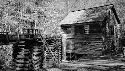
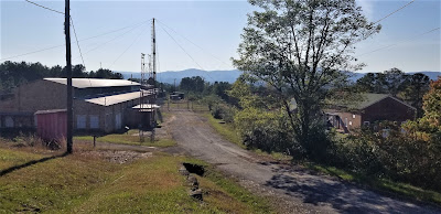
Moving right along into Desha County, Arkansas, outside the town of Dumas, was a pioneer village and museum (GC3EYQ4). This collection of old buildings from around the area give you an example of what life was like for those seeking a new opportunity on the western frontier. Like this restored pre-1850 log home with the open breezeway in between two rooms to help with ventilation.


Or how about this old country church...


Not exactly luxury, but after working a long hard day on the farm or ranch, even the most meager thin beds would be welcome rest. Most bedrooms were multi-purpose rooms for sitting, reading, or even spinning wool or cotton into yarn or thread.


The next county over was Lincoln County and another quick cemetery geocache (GC1NY24). On the west side of Star City, Arkansas was the Leek-Drake Cemetery. With over 1500 permanent residents here and a lack of time, it was a short find the cache visit and a quick glance around. Nothing jumped out to peak my interest further, so down the road we went.

The same thing happened again in Cleveland County in the town of Rison. The Rison Cemetery geocache (GC1YE4B) was a quick find, a glance around, and move on down the road.

Now usually on my road trips, I have the targeted geocaches planned out so that I can get the needed counties to fill in the blank spaces on my geocaching map. And on occasion there's the unexpected sites that make traveling the back roads worth while too.

Passing through Kingsland, Arkansas, also in Cleveland County, we see the "Welcome to Kingsland" sign with the added "Birthplace of Johnny Cash." Well I'm not a country music fan but I do know who Johnny Cash is. And I've got some friends who are fans, one of which named his two dogs Johnny & Cash. So after a quick Google search we find the location and drive to the neighborhood. The house is gone and is now a community park. There's a church next door too. Along the street is this simple memorial. I kinda expected it to be in better condition than it was and was a little disappointed. But we can say now that we stopped at the "Birthplace of Johnny Cash."


Stopping in the town of Fordyce for a geocache in Dallas County, we come to the First Presbyterian Church (GC7WCDF). The church was first organized in 1883. As the congregation grew, this was their third building and was erected on this site in 1912. Now on the National Register of Historic Places, funds are being raised to restore this old church building.


Continuing our drive westbound, US-79 cuts through the northwest corner of Calhoun County. And finding a quick roadside geocache (GC8FZ1A) at the Welcome to Thornton sign filled in another empty spot needed on our geocaching counties map.

Crossing into Quachita County, the geocache in the Salem Cemetery (GC8TN20) gave us credit for that county. There are almost 2000 interments here in Salem, but no time to look around as it is getting late in the day, dinner time, and we're both hungry.


Our final geocache for the day was at the St. Matthew Cemetery (GC37P88) in Columbia County. About 400 interments, this cemetery dates back to 1867 and still serves the community.


Well we still have not yet made it to Texas. I'm sure we've all heard of "football time." Like the "two-minute warning" actually takes 10-15 minutes of real time. Or when a woman says they'll be "ready in a minute" when getting dressed up for a night out, turns into an hour later. 

Well the same goes for geocachers and road trips. According to Google maps, we should have crossed the Texas state line in about 5 1/2 hours from our start this morning. Here we are 10 hours later and still in southwest Arkansas. But we got to see a lot and had fun too. I mean what's the point of traveling for work if you don't get to enjoy the trip?

Time to finally get some dinner and find a place to stay for the night. We got one more Arkansas county to get to in the morning. Then finally back in Texas. I hope you enjoyed the ride. Post a comment to let me know you were here and feel free to share our blog with your friends. See you again real soon.

To follow along on our travels and keep up with my latest blogs, you may do so here of course. But also by using your favorite of these social media platforms: FacebookMeWeGabRedditParlorTwitterRVillageGETTR and Instagram. These all link directly to my profile. Again, please feel free to comment and / or share.

Saturday, April 2, 2022

2020-10-19: Westbound Roadtrip Through Tennessee Civil War History and a Walking Tall Sheriff

Here we are on Day #2 of our westbound roadtrip. Today's trip took us from the Civil War history in Chattanooga through the backroads along the southern route of Tennessee towards Memphis. There's a lot of sightseeing to do, a lot of new geocaches to find, and new counties to add to my map. So climb aboard and let's go for a drive...


With its railroads and riverboats, the city of Chattanooga was a vital transportation center during the Civil War. Both armies recognized its importance. In the late summer and fall of 1863, several key military actions decided the fate of Chattanooga, and helped determine the fate of the Confederacy.

September 18-20: About 10 miles south of Chattanooga near West Chickamauga Creek, Confederate forces defeated the Union Army in a bloody two-day battle. The Federals withdrew to Chattanooga and fortified the city.


September 22 - November 23: Confederates laid siege to the city of Chattanooga to force the Federals to surrender. Confederates occupied positions along the Tennessee River, Missionary Ridge, and Lookout Mountain. In late October, the besieged and hungry Federals managed to open a supply line through Lookout Valley into the city. With fresh troops and supplies, they were ready to fight by late November. On November 23rd, Union troops stormed and captured Orchard Knob, a hill to the east of their defense line in the city.


November 24: Union forces drove the Confederates from their position on Lookout Mountain. Because the mountain was partially shrouded by fog, the action was also called the "Battle Above the Clouds." The following day, Union forces stormed and shattered Confederate unites occupying Missionary Ridge. The siege was broken and Chattanooga became the Federal base from which Maj General William T Sherman would launch his Atlanta campaign in the spring of 1864.


Point Park preserves strategic high ground captured by Union soldiers during the Battle of Lookout Mountain in 1863. Today it is part of Chickamauga and Chattanooga National Military Park and the location of our first virtual geocache (GC41C9). The New York Peace Monument, the centerpiece of the park, symbolizes the reconciliation of the North and South.


Driving down off Lookout Mountain, I made a stop near the base of the Incline Railway for our next virtual geocache (GCMFYC). The Incline Railway up historic Lookout Mountain is the world's steepest passenger railway. The first Incline up Lookout Mountain opened in 1887. It ran from the 38th Street area in St. Elmo to just below the Point. The second Incline, engineered by John Crass, opened November 16, 1895, and is the Incline that is still in operation today. The success of the second Incline was the primary reason that the first Incline closed in 1899.

The incline, 1,972 feet long and rising 1,450 feet, is superbly designed to suit its location. It makes use of a variable grade, ranging up to 72.7 percent near the top, to compensate for the changing weight of the cables as its cars move. One of the cars has flanges on the inside of its wheels, the other on the outside, allowing the cars to pass midway with no moving parts in the track turnouts. Both cars have self-contained emergency brakes. Originally powered by steam, the incline now is driven by two 100-horsepower motors. The latest evolution of the incline cars were just recently installed in March 2020.


Robert Craven built the first house on the hillside of Lookout Mountain in 1856. Seven years later, the Confederate Army occupied Lookout Mountain and Craven's house became the headquarters of Brig. Gen. Edward C. Walthall. On November 24, 1863, Union troops stormed the mountain and pushed the Confederates around to the north end.


When Robert Craven returned to his home after the battle, he found little of his home standing except the basement, the chimney, and the stone dairy. In addition to artillery damage, soldiers had stripped the house looking for souvenirs and firewood. The Cravens rebuilt the house as it currently stands.


Many of the Civil War Battlegrounds have monuments scattered throughout placed by the various states as a memorial to those soldiers who fought and died while representing their states. This particular memorial statue was honoring those soldiers from the state of New York. There is another monument nearby from Illinois which also happens to be a virtual geocache (GC621C).


Finally leaving Chattanooga and Lookout Mountain to continue our roadtrip westbound, we enter the town of Winchester in Franklin County. The town was named after James Winchester (1752 - 1826), who was a soldier in the American Revolution, Speaker of the First Tennessee Legislature, and Brigadier General in the War of 1812. The town of Winchester was created as the Franklin County seat on November 22, 1809.

One of the many monuments and historical markers located within the town square was this one dedicated to the memory of Colonel James Lewis (1756 - 1849). It is also another virtual geocache (GC9366). Col. Lewis served with distinction in the Revolutionary War. He participated in the battles of White Plains, Trenton, Princeton, Brandywine, Germantown, and Yorktown. He erected the first brick house in town and was one of the appointed commissioners for the erection of the first courthouse and jail in Franklin County. There are two other historical accomplishments, but that would give away the answer to the virtual geocache.


The one building that caught my eye the most was the Oldham Theater. Apothecary and druggist shops were originally on this corner from the 1820's thru 1900 with doctors offices upstairs during the 1880's. Later the street level housed the Franklin Grocery and Bakery until the 1930's. The spacious upstairs was hosted large civic gatherings and parties while leased by the Business and Professional Women's Club. The old building was razed in 1949 for construction of a theater.

George E. Oldham, who owned the Rivoli Theatre on the south side of the square, bought this theater from his brother-in-law in 1949 while it was still under construction on the north side of the square as a replacement for his older theater. Unfortunately, George Oldham passed away in September 1949 before the theater officially opened a year later on September 14, 1950 and named in his honor.

Though virtually unchanged in appearance, ownership changed several times and a major renovation began in 2009 and took three years to complete. The upgrade to the two-screen theater included incorporating digital projection equipment, installing surround sound, new curtains and new seats. I think it's pretty cool to see these old theaters still in use.


Continuing our drive west on US-64, the next Tennessee county needed for our geocaching map was Giles County. We stopped in the town of Pulaski at this unique and historical cemetery and memorial park (GC5BQW0). The first cemetery in Pulaski was on the outskirts (at that time) of town in 1817, in a field where interments continued until 1883 when all of the lots were full. Over the years abandoned and nearly forgotten, the cemetery fell into disrepair.

Until in 1969, Pulaski began an urban beautification project here to transform the old cemetery into a city park. The overgrowth was cleared out and headstones were located, identified and cleaned. The headstones were then mounted; the smaller ones in curved structures on the ground and the larger ones into a stone wall along the back of the park. A few monument markers that were still standing after the years were left where they were. Finally, landscaping, paved paths and lighting were added. The interred remains were left in their original locations as it could not be determined who was where except for the few monuments that were still standing.


Moving on into Lawrence County and the town of Lawrenceburg, we find our next two geocaches and a look back into Tennessee history. First was the Garner Mill Earthcache (GC1PPNT). The Garner Mill was used extensively from 1825 to 1849. It was built in 1820, and functioned as a grist mill initially, and then was converted to a water powered sawmill in 1851. Both the dam and the mill were destroyed in the flood of July 13, 1998. The ruins of the foundation still survived the flood, as well as the footings for the dam on the far side of the river. It is listed on the National Registry of Historic Places.


Closer to the center of town was our next geocache at the home of Davy Crockett (GC6K21P). David Crockett lived in this cabin from 1816 to 1822. He was one of the commissioners who laid out the county and selected the site of Lawrenceburg, a colonel in the militia, Justice of the Peace, member of the legislature, and operator of several industries on Shoal Creek during his residence here.


In the Lawrenceburg town square is a statue of Col. Davy Crockett. Born in East Tennessee on August 17, 1786, he gave his life for Texas Liberty and Independence at the Alamo that fateful Sunday morning on March 8, 1836.


Still heading westbound on US-64 picking up new geocaching counties, I make a quick roadside stop for a geocache in Wayne County (GC6B2WF). It was a good thing I stopped for the easy geocache because my target cache was a DNF (GC69K7B). But the good thing is that you never know what you're gonna see while geocaching. Like this homemade rocket ship trike!


Next up was Hardin County in the town of Savanna along the banks of the Tennessee River. There once was a house here built by James Rudd, a pioneer ferry operator, long before the US-64 highway was crossing the river. That house was replaced by another built by David Robinson, whose son-in-law William H. Cherry, improved and enlarged it. During the Civil War, "Cherry Mansion" became the headquarters for Federal Army commander Major General C. F. Smith. When he died he was succeeded by Major General Ulysses S. Grant. Maj. Gen. Wallace died here after being mortally wounded at Shilo.


Unfortunately the geocache had gone missing and I had to DNF it (GC2TVN9). Still needing the county, I stopped a couple blocks away at this small park memorializing the Battle of Shiloh where I found the geocache hidden here (GC1F8PZ).


Just a short drive over to McNair County, and we stop for our next geocache (GC5T5DM) highlighting a local hero and nationally known figure. The movie "Walking Tall" made Sheriff Buford Hayes Pusser a household name. He was born near Finger, Tennessee on December 12, 1937, raised here and graduated from Adamsville High School in 1956. About a year later, Buford moved to Chicago where he worked as a die cutter, attended Worsham College, and wrestled professionally on weekends. While in college he met and married Pauline Mullens.


The saga of Bufford Pusser and the illegal activities on the Tennessee-Mississippi state line began early in 1957, when he was beaten severely at a club in that area. In January 1960, he was arrested for assaulting the owner of a club on the Mississippi side of the3 state line. Bufford received a verdict of innocent at a trial held in Corinth, MS.

Buford's career in law enforcement began when he was appointed Chief-of-Police of Adamsville in 1962. He was later elected Constable and then Sheriff of McNairy County, serving three terms. During his first year as Sheriff, Buford was stabbed on several occasions and along with his deputies raided over forty-two moonshine operations. In 1966 he was forced to shoot in self-defense the operator of a motel on the state line where he had gone to investigate a robbery. In January of 1967, Buford was shot at point blank range four times by two men he had stopped in the state line area. The most deplorable episode in his career began one early morning on August 12, 1967 when he, accompanied by his wife, was enroute to answer a call. They were ambushed on New Hope Road, killing Pauline with Buford barely surviving the ordeal being severely wounded himself. In December 1968, Buford answered a call for help and a known murderer opened fire on him, leaving him no choice but to shoot and kill him in self-defense.


Sheriff Buford was selected in 1970, by the Jaycees, as one of Tennessee's "Outstanding Young Men of the Year." He had signed a movie contract to depict himself in a sequel to the movie "Walking Tall" when he was suddenly killed in an automobile accident on Highway 64, west of Adamsville, on August 24, 1974.

Bufford Pusser's experiences have inspired seven movies, five books, a television series, several magazine articles, and a Colt Commemorative Limited Edition handgun, all depicting the life of a man who "Walked Tall."


Our last geocaching county of the day is for Hardeman County and the town of Bolivar, Tennessee. It was a quick park and grab geocache to claim a find in the county (GC4WGKP).

From there it was just a couple of blocks south to the Polk Cemetery. Even though there's wasn't a geocache there, it was historical and worthy of a stop. The land was acquired by James K. Polk Jr. and others on October 23, 1845 as a family cemetery for the descendants of Ezekial Polk. Colonel Polk, the patriarch of the Polk family in Tennessee, was the grandfather of President James Knox Polk. The elder Polk was instrumental in framing the Mecklenburg Declaration of Independence and served in the Revolutionary War. He lived in Maury County before settling in Hardeman County.


That's all for today. We continue heading west on US-64 and find a place to stay for the night just outside of Memphis. I'm thinking a trip to Elvis's Graceland in the morning might be a plan. I hope you return to see the outcome. Until then...

To follow along on our travels and keep up with my latest blogs, you may do so here of course. But also by using you favorite of these social media platforms: FacebookMeWeGabRedditParlorTwitterRVillageGETTR and Instagram. These all link directly to my profile. Again, please feel free to comment and / or share.

Friday, February 18, 2022

2020-10-18: Westbound Roadtrip Through North Carolina and Tennessee

Westbound and down, eighteen wheels are rollin'.... OK, so there aren't 18-wheels. But our time in North Carolina has come to an end and I gotta week to start the next project in Guy, Texas. TIME FOR ANOTHER ROAD TRIP! Time for geocaching, sightseeing, and exploring more backroads and byways between here and there.

Today we drove all the way over to Chattanooga, Tennessee. We discovered an old mill, a waterfall, a giant Harley-Davidson, a copper mine, and a historic cemetery. So climb into the GeoJeep and let me show you...


Not to take up too much time starting out, I quickly drive up to I-40 and head westbound. The first few hours were nonstop all the way to Cherokee, NC and our first geocache (GCGYMA).

For 50 years, nearby farmers brought their corn and wheat to Mingus Mill, built in 1886. The miller usually charged a toll of one-eighth of the grain the customer brought for milling. The gristmill's stone was turned by a water-powered, cast-iron turbine. From water pressure built up in the penstock at the flume's end, the turbine generated 11 horsepower, enough to run all the mill's machinery. On the second floor, the smut machine blew wheat grain free of debris, while the bolting chest separated ground wheat into grades by sifting it through fine to coarse bolts of cloth.

Mingus was the largest gristmill in the Smokies. Its 200-foot-long wooden flume brings water to the mill's turbine. As early as the 1820's, more progressive millers began using turbines to power their mills rather than waterwheels. The Mingus family sold the mill to the National Park Service in the 1930's.


Continuing the scenic drive west on US-74, we headed for Juney Whank Falls and our next geocache (GCMBAZ). This puzzle cache requires gathering information along the 4.4 mile Deep Creek - Indian Creek loop trail. However once we arrived at the trailhead we weren't up for a long hike. So we just took the short hike to the first of several waterfalls for some photos.


Here's one of those reasons why I like driving the backroads and byways through rural towns and communities across this great country. Passing by Cherokee County Cycles, I spotted this HUGE Harley-Davidson custom motorcycle along with a couple of other cool vehicles in the parking lot. I just had to pull in and get a few pics!


Crossing over into Tennessee, we check out the Great Copper Basin Earthcache (GCNP87) and a new caching county of Polk County. In 1843, a prospector, hoping to find gold south of the Coker Creek mine fields, instead located one of America's richest copper reserves. Over the next century, American and foreign companies chartered more than a dozen copper mines in the Ducktown Basin. The last mines closed in 1987. Many of the buildings still remain today.


We ended our day in Chattanooga at the National Cemetery for two virtual geocaches (GC5148, GC4E66). On Dec. 25, 1863, Maj. Gen. George H. Thomas, “The Rock of Chickamauga," issued General Orders No. 296 creating a national cemetery in commemoration of the Battles of Chattanooga, Nov. 23-27, 1863. Gen. Thomas selected the cemetery site during the assault of his troops that carried Missionary Ridge and brought the campaign to an end. The site Thomas selected was approximately 75 acres of a round hill rising with a uniform slope to a height of 100 feet; it faced Missionary Ridge on one side and Lookout Mountain on the other. Gen. Grant established his headquarters on the summit of the hill during the early phase of the four-day battle for Lookout Mountain.


By 1870, more than 12,800 interments were complete: 8,685 known and 4,189 unknown. The dead included men who fell at the battles of Chickamauga, Missionary Ridge and Lookout Mountain. There were also a number of reinterments from the surrounding area, including Athens, Charleston and locations along the line of Gen. Sherman’s march to Atlanta. A large number of men—1,798 remains—who died at the Battle of Chickamauga were relegated to unknowns during the reinterment process. In addition to Civil War veterans, there are 78 German prisoners of war buried here.

The Andrews Raiders Monument, erected by the state of Ohio in 1890, is among the most unique memorials in the cemetery. The granite base and die is topped with a bronze replica of “The General,” the Civil War-era wood-burning locomotive famous for its great chase of 1862.


Today, the Chattanooga National Cemetery encompasses just over 120 acres and nearly 60,000 permanent residents.

After 300 miles of driving, it was time to call it a night. Tomorrow is another day with new adventures and things to see. I hope you have enjoyed today's journey and will return for many more...

To follow along on our travels and keep up with my latest blogs, you may do so here of course. But also by using you favorite of these social media platforms: FacebookMeWeGabRedditParlorTwitterRVillageGETTR and Instagram. These all link directly to my profile. Again, please feel free to comment and / or share.

Friday, November 29, 2019

2018-01-02: Driving Home From Maryland to Texas Days 5, 6, and 7

Well I made it back to Texas. Making sure that I made it back today so that I can be at work tomorrow, I made fewer Geocaching stops. After waking up Sunday morning and making sure my wife had everything she needed, I said my goodbyes and packed up the GeoDogs into the car.


Day #5: I drove just over 700 miles from Baltimore to the western outskirts of Nashville. Only one quick cache (GC4MH5D) at a truck stop in Tennessee for gas, food, and dog walking.

Day #6: Yesterday I'm up early and hit the road on I-40 westbound. I finish Tennessee, through Arkansas, and into Texas. In Texarkana, I turned south down to Atlanta, TX  for my first cache in Cass County. A virtual geocache called Old Texas Rails (GC7EF2) at the old railroad station. The town was established in 1871 when the Texas and Pacific Railroad made a stop here and named after Atlanta, GA where many of the early settlers were from.


Continuing west on Hwy 155, I get to the small town of Avinger, also in Cass County.  At the Mt. Plymouth cemetery was my next cache (GC13TKN). Most of the cemetery was well kept. But there was this one area off to the side that was in bad shape. It's sad to think that the church next door wouldn't take better care of it.


My next county was Upshur County and the town of Ore City. The cache was called Twisted Chimney (GC69QAP). It was down the hill from this unique chimney which was the only remains of an old house. The name Ore City comes from the ore deposits found here prior to the Civil War. Only small amounts were extracted until 1910 when a large scale operation finally materialized.


Camp County was next on my list and a stop for the Life of Riley cache (GC17BXV). From the historical marker: "The oldest documented grave in Riley Cemetery, that of Louise Gillum, dates to 1859. The land was acquired by John Riley Sr, in 1875, and became known as Riley Cemetery. Early settlers buried here include John and Elizabeth Keeling Riley and their five children; Confederate Captain George W. Keeling, a former member of the Georgia State Legislature; the family of M. H. Couch, whose name graces that of Couch Mountain, Camp Counties highest elevation point; and many area pioneers whose decedents continue to live in the area and maintain the historic graveyard." 


Also in the Riley Cemetery is this marker which tells another story. "First Grave Riley Cemetery; Unknown Child; Oral history tells of a family migrating west on the Old Pitt-Jefferson Road, who requested and were granted a site to bury their child. From several historical sources this was the beginning of the Riley Cemetery circa 1850's."


Day #7: This morning I started out in Decatur, Texas in Wise County. I was planning on just grabbing the quick airport cache. I still had 400 miles to drive today and didn't want to arrive late in the evening. Well I turned down the wrong road and I figured well I'll take a quick look at the Oaklawn Cemetery. After about 30 minutes of looking at headstones, I realized I'm spending way too much time here. So as I'm exiting through the gate to grab the other cache, I though well I'm already here lets get this cache (GC6CMT2). But then there's a BUNCH! OK, just one. Yeah right! I find this one and then decided to get another since I'm already here (GCXT4X). Finally deciding the rest will have to be skipped in order to get back on the road again. I got 3 more counties to get before making my way back to I-20 Westbound. Ugh so depressing to skip caches.


Moving on my way to Jack County, I grabbed a quick roadside cache fittingly called "Traveling" (GC6AE23). Following US-380 to Young County to find the "Saints Alive" geocache (GC1T3V6) near a church. Then over to Stephens County for my last geocache (GC2WEA7) of the day.

That finished off most of my NE Texas counties that I needed to get. Now I made the 260 mile beeline back to Monahans to end the week.  Time to unpack, do laundry, and prepare for work tomorrow. And start planning my next trip.