Showing posts with label trail. Show all posts

Saturday, January 15, 2022

2020-07-03: A Long Weekend Geocaching Counties and Hiking in Western North Carolina

Well we're working in North Carolina and have a 3-day holiday weekend. Do we chill at the RV Park or go exploring the Smoky Mountains and Geocache the remaining six counties to complete the state? It's a roadtrip of course! Grab the hiking boots, hop into the GeoJeep, and let's go sightseeing along the backroads of North Carolina!


Leaving the Lake Norman Motorcoach Resort behind for a few days, we headed west on NC Highway 18 until we got near Pleasant Grove. There we made a detour over to a bridge on Old North Carolina 18 for a First-to-Find attempt at a geocache published two days earlier (GC8VWYF). Another geocacher tried to find it the same day it was published without any success. I tried searching for nearly 30 minutes. But it wasn't for me to find on this day. I ended up having to log a DNF.

Driving north on US-321, I get off at the Mulberry exit for our next geocache (GC8MRYY). It was located near Silvervale Falls. These cascading falls are about 80 feet from top to bottom. Being this far from the Blue Ridge Parkway, there aren't as many tourists visiting these waterfalls. Only enough parking for 3 cars and we didn't have any problem. But worth the stop if you happen to be nearby.


One of the other reasons I like geocaching and traveling the backroads is that you never know what you might come across. Like this old rusty car, truck, and tractors lined up on the side of the road. I just had to stop and get a few photos.


Our next stop WAS to be Blowing Rock and then Grandfather Mountain. I've visited the Smokey Mountains and the Blue Ridge Parkway many times. However I have never made it to these two popular tourist destinations. Today it was going to be another of those times. It was July 4th weekend and the places were packed full and we did not want to contend with the crowds. So we continued on southbound down the Blue Ridge Parkway.

One of the first photo opp stops we took along the parkway was at the Wilson Creek Valley Overlook. A great view and you can see for miles!


Our next stop was a hike for a virtual geocache in the Linville Gorge Wilderness Area. The Linville Gorge Wilderness is part of the Pisgah National Forest. The gorge is formed by the Jonas Ridge on the east and Linville Mountain on the west and is bisected by the Linville River which drops 2,000 feet into the valleys below.

The virtual geocache (GC3A44) was a hike down the Spence Ridge Trailhead. This trail was supposed to take us down to the Linville River where we were to find the "House Rock," a flat top rock formation in the river that looks like a house. I wish I could show a picture of it, but we never made it. After about an hour of hiking, we were slowly getting closer but the destination appeared to be staying off to the right. Finally we decided to turn around and head back to the GeoJeep. As we were hiking back I noticed the correct trail we should have stayed on teeing off. Oh well, maybe next time.


Driving our way around to the other side of the Linville River we headed for our next virtual geocache called "Look At That" (GCG9YT). After 3.5 miles of gravel road, a little rough in a few spots, we made it to our destination at the Wiseman's View Scenic Overlook. Just a short walk from the parking area and you'll arrive at this viewing platform high above the gorge.


Driving back along the 3.5 mile gravel road, which is the Old NC 105 / CR 1238, I spotted this old road marker off the side in the weeds. After a few hours of research, Andrew Milton Kistler (1871-1931) was originally from Pennsylvania and became a prominent businessman in Morganton, Burke County, NC. First established in 1926 as the primary route between Nebo and Linville Falls, a 24 mile road that has since been rerouted and improved. The remaining Old NC 105 is now 17 miles of gravel road which can require 4x4 in some areas. That just added to the adventure in the GeoJeep.


We ended the day in Marion, NC. It was a pretty good day with the sightseeing, the hiking, the off-roading, and a little bit of history. I hope you have enjoyed todays adventure. See you back soon for another day of exploring the Smoky Mountains in Western North Carolina.

To follow along on our travels and keep up with my latest blogs, you may do so here of course. But also by using you favorite of these social media platforms: FacebookMeWeGabRedditParlorTwitterRVillageGETTR and Instagram. These all link directly to my profile. Again, please feel free to comment and / or share.

Saturday, August 28, 2021

2019-12-28: Spending the Day in Big Bend National Park

It's been 13 years since I was last here at Big Bend National Park in West Texas. Spending the last few years just a few hours north of here, I figured it was about time I paid another visit. We spent two nights in Alpine, TX as our base so we could get here early, stay all day, and not have a long drive home afterwards. Big Bend NP is over 1200 square miles and that's a lot to explore and see. So let's get going!


We arrived just after dawn to a cloudy morning which kinda hindered having some great sunrise photos. Our first geocache was an earthcache called "Fins of Fire" (GC3AZVV) facing the Chisos Mountains to the east, describing the layers and spikes and the creation of the mountains from volcanic activity.


Continuing the beautiful route down the Ross Maxwell Scenic Drive, we arrived at the Solol Vista Overlook and another earthcache (GC2NJRH). The amazing views here are awe inspiring. And from this vantage point we barely get a glimpse of our destination Santa Elena Canyon some fourteen miles in the distance. From here though it's just a tiny notch in the mesa across the valley.


In the panoramic photo below taken from the Sotol Overlook, from left to right are: Trap Mountain, Goat Mountain, Santa Elena Canyon, Kit Mountain, across the valley to Tule Mountain, Burro Mesa, Little Christmas Mountain, and Christmas Mountain.


After the overlook, we stopped at Tuff Canyon for another earthcache (GC72D1C). Tuff Canyon is the deepest of the dry washes in Big Bend NP. This also makes it very dangerous during or after a rain as the gathering waters pick up velocity and can cause a flash flood rushing between the canyon walls. Over time the rushing waters slowly dig a deeper channel while at the same time eroding and smoothing the layered rock walls.


The mountains and cliff walls are plentiful. Just driving the roads, you won't even need to get out of your car to be amazed at the views.


Now we get to the Santa Elena Canyon observation area (GC37ECH). The Santa Elena Canyon is one of the most famous landmarks within Big Bend National Park. Looking from the overlook area, that's the United States on the right, Mexico on the left, and the shallow Rio Grande River flowing up through the middle and curving to the left. A lot of people stop there to get their photos. However if you keep following the road around, it will take you down to the entrance, or should I say the exit.


Where the Rio Grande exits the canyon, there's the Santa Elena Canyon Trailhead. The Terlingua Creek drains into the Rio Grande River just as it exits the canyon. You can see it in the next photo coming in from the left. Most of the time the water level is low enough and you can easily walk across rocks without getting wet. Once you cross over and climb the short hill you enter the trailhead that has been paved creating an easy hike with stairs and switchbacks up 160 feet to the point from which I took the photo.


Once you make the short hike up and over at the trailhead, you make your way down the trail into the cool canyon. Because of the 1500 feet canyon walls that seem to raise up forever, they block out the sun except for the short time it is directly overhead. We continued our hike down and back to see how far we could go. Officially it's a 1.5 mile out and back hiking trail.


At this point, we came to the end of the trail. This is about as far as you can hike without getting wet. Now I was wanting a kayak so I could keep going to see what's around the corner. One of these days I just might do that.


Backing up a little ways there's this huge rock that had fallen near the edge of the bank of the Rio Grande. I talked Candy into climbing out on the rock with me and handed my phone to another hiker to take our photo. I think this turned out much better than trying to take a selfie and still get the full canyon effect.


Having made our way back in the GeoJeep, it was time to hit some of the offroad trails. First we drove back up the Ross Maxwell Scenic Drive and looped around over to the Panther Junction Visitors Center. This time we finally bought one of those National Park Passport books that you get stamped each time you visit a national park or historical site.

From there we made our way down to Glenn Springs Road. It's a gravel road that even a regular car can make it through, see the first pic at the top of the blog. There might be some parts that may be a little rough, but I'd drive down most of it if I still had the Prius and the turn around if I got to an impassible section.

After several miles it turns into Black Gap Road as it nears the spring. There it does become a rougher section that really requires high clearance vehicle. Just past the Glenn Spring primitive campsite I found my next virtual geocache (GCR2A8). The U.S. Calvary once used this location for a few years. If you look hard enough you can still find parts of the foundations of some of the buildings. At the top of the nearby hill you'll find some scattered wooden crosses for the cemetery. To get credit for finding the virtual cache you need to email the number of crosses. The Find-A-Grave website only lists five memorials here. If you use that number you won't have the correct number as there are more than that. And not having any names on the wooden crosses, they are known only to God.


Another hour or so of offroad fun in the GeoJeep and we make our way to the exit roads and back up to Alpine, Texas. It wasn't until later that I realized the Black Gap Road was one of the trails in the Jeep Badge of Honor series. If I had used the BoH app to check in from the trail, I could have gotten my first badge. Oh well, I guess that's a good excuse to have to come back and explore some more of the Big Bend National Park. There is still much to see out here that I haven't gotten to yet. And I recommend this place to be put on your bucket list one day. Just try to avoid summer as the temps are easily in the triple digits!

To follow along on our travels and keep up with my latest blogs, you may do so here of course. But also by using you favorite of these social media platforms: FacebookMeWeGabRedditParlorTwitter, and Instagram. These all link directly to my profile. Again, please feel free to comment and / or share.

Saturday, August 14, 2021

2019-11-25: Our Return to Hiking the Lighthouse Trail in Palo Duro Canyon Texas

Welcome back friends, family, geocachers, RV'ers, Jeepers, and everyone else who just happened to drop by my AwayWeGo's Geocaching Adventures blog. This is more about just geocaching though. I'm here to share my travels around this great country. The geocaching just helps me find some of those out-of-the-way very rural backroads "not-on-your-tourist-map" great sightseeing treasures.

If you'd like to follow along via many of the social media sites. I'll provide links at the end of this blog. I'd also love to hear from you, so please feel free to comment here or on the social sites. And please by all means share my stories with your friends too. I hope my stories inspire you to get out and explore.


Well after my opening paragraph, today we DID do the touristy thing and return to the Palo Duro Canyon. We both had this Thanksgiving week off so we decided to take a drive up to Amarillo, Texas and do some hiking in the Canyon. We were here a few years earlier to make this hike and that's where I proposed to her. (see "She Said Yes!") We've been married now for just over three years.

Plus along the hiking trail up to the famous rock formation called The Lighthouse, there was a trail of geocaches hidden. Many of those caches had been missing and we had to DNF them. They've since been replaced and now we can redeem those DNF's.


The weather couldn't have been better! It was cool out and with sunny skies, it made for perfect hiking. It also made for some pretty good photos I think. This next photo I call Sitting Chief. I don't know if it has an official name, but that's what I think of every time I see it.


Some background info from the Palo Duro website: The history of the canyon goes back a long ways. The Clovis and Folsom peoples first lived in the canyon and hunted large herds of mammoths and giant bison. More recently, the Apache, Comanche, and Kiowa took advantage of the canyon's plentiful resources. These early cultures left behind rock art and bedrock mortars where they ground mesquite beans and roots for food. The early Spanish explorers probably discovered the canyon and called it Palo Duro, Spanish for Hard Wood.

The Red River War between the U.S. Army and southern Plains Indians lasted from June 1874 to the spring of 1875. A decisive battle occurred in the canyon on Sept. 28, 1874. Colonel Ranald S. Mackenzie led the 4th U.S. Cavalry in a surprise attack at dawn on a camp of Comanches, Kiowas and Cheyennes. The families fled up the canyon, leaving everything behind. MacKenzie’s troops captured 1,400 ponies and shot most of them. Soldiers also burned all the teepees and winter stores. With no horses or supplies, the families had no choice but to return to the reservation. The reign of Native Americans over the Panhandle plains ended soon after.


Charles Goodnight, a former Texas Ranger, drove 1,600 Longhorn cattle to Palo Duro Canyon in 1876. He and his partner John Adair, an English aristocrat, founded the JA Ranch in 1877. At its peak in 1885, the ranch grazed 100,000 head of cattle on 1,325,000 acres spread across the Panhandle. After Adair died, his widow, Cornelia, took over as Goodnight’s partner. In 1887, Goodnight decided to scale back his ranching activities. The partnership ended that year, and the partners divided the land. Most of the canyon belonged to the JA Ranch up until 1890. Adair descendants continue to run the JA Ranch today.

The state bought the land for the park from Fred S. Emory in 1933. Soon after, Civilian Conservation Corps workers arrived, and spent the next five years creating a park. First, they built a camp for their home base, and then they set to work in the immense canyon. The men built the winding road to the canyon floor. Until it was finished, they hiked in and out of the canyon on what is now the CCC Trail. CCC workers made all of the park’s original improvements, including El Coronado Lodge (now the Visitor Center), the cabins on the rim and canyon floor, and trails. Designers planned the park to maximize views and complement the surroundings. The CCC used local stone and wood for building materials. In addition, workers forged decorative metal and crafted furniture. The park opened in 1934 before it was complete. It is the second largest park in the state parks system today, with about 28,000 acres


So of the 6 or 8 remaining caches along the trail that we needed to find, we only DNF'd just one... again. Since our last visit there was added a virtual geocache (GC7B6H7) and an earthcache (GC81YE8) up at Lighthouse Point. Upon arriving, we did the obligatory oohs and aahs, took in the views and captured some photos. Then after a short time we hunted for the answers for the caches before descending down into the canyon for our hike back to the parking lot. It is a beautiful Texas State Park and one of my favorite places in the country. I'm sure we will be returning again often.


I hope you have enjoyed our visit today to Palo Duro Canyon up in the panhandle of Texas. To follow along on our travels and keep up with my latest blogs, you may do so here of course. But also by using you favorite of these social media platforms: Facebook, MeWe, Gab, Reddit, Parlor, Twitter, and Instagram. These all link directly to my profile. Again, please feel free to comment and / or share. Until next time... see you out on the road!

Saturday, August 7, 2021

2019-09-02: Back to West Texas and Finding Geocaches in San Saba, an Old Suspension Bridge, Cemeteries, and a Funny Story

Ugh.. Back to West Texas Again!! Well my time in North Central Texas is over. I had plenty more places to explore and geocaches to find. But I gotta go where the job tells me to go. They needed a surveyor to start a new solar project in McCamey, TX, so I trained my replacement at the wind farm in Gilliland.

I think I have found almost every geocache between Killeen and McCamey, so I'll probably be driving WAY outta route to find some caches and places to explore. So who's ready for a roadtrip? Hop in the GeoJeep and let's get going.


My first stop is taking the rural FM 580 backroad west of Lampasas. Wasn't anything to see here. Just a backroads geocache out in the middle of nowhere (GC15R7W).

Arriving in San Saba, Texas to the Welcome sign on the south side of town, I was greeted by a unique cache container (GC729ET). This cleverly disguised micro cache might be easily skipped if attempting at night.


One block off the main street through town is this 100 year old Methodist Church and my next geocache (GC7285N). I had been wanting to get this one the previous times passing through San Saba, but it is usually a Sunday and the busiest day of the week for this building. On this morning there were still some folks around front (so no photos), but in back where the cache was it was deserted. Found it in short order and continued on my way.

One more stop for the San Saba Cemetery (GC727WY). Previously the Odd Fellows Cemetery, it is located on 17 acres of land about 800 yards north of old town San Saba. On April 18, 1883, the San Saba Chapter of the Independent Order of Odd Fellows (IDOF) purchased 10 acres of this land from J.J. Stockbridge to establish a cemetery, which they maintained for 45 years. On April 3, 1929, the newly incorporated San Saba Cemetery Association purchased the cemetery for $1.00 and an additional 7 acres from Mrs. May Holman, also for $1.00. In 1935 burials from San Saba's earliest City Cemetery, now Rogan Field, were reinterred here.

Once again on the rural backroads north of San Saba, county road 500, I stopped at this cross on the side of the road. Eighteen year old David McBride is buried in the above cemetery, but I can only assume that this roadside memorial was the location where his life was taken so soon.


Continuing up the rural backroads on the way to my next trio of caches, I saw all these beautiful purple plants. They look like mini-pineapples, but very sharp prickly thorns all over them. After taking some photos, I drove on.


The next three geocaches were all in the vicinity of the Regency Suspension Bridge. (GC1A7VT, GC1A1DW, GC1A1DM) Built in 1939 mostly by hand and restored 60 years later in 1999, the Regency Suspension Bridge spans 325 feet from tower to tower. The towers rise 30 feet above the bridge floor, which is 16 feet wide. Engineers list the overall length at 403 feet. Locally known as "The Swinging Bridge", it connects San Saba and Mills Counties across the Colorado River. On December 29, 2003, vandals set the wood surface on fire burning a whole through some of the 4x12 inch planks. Thankfully the bridge was once again repaired. After enjoying the views and taking lots of photos, I was able to find 2 of the 3 geocaches. (08-09-2021 UPDATE: I'm being informed that vandals have struck again and set the bridge on fire and has been closed to traffic.)


Working my way through the maze of gravel roads back south trying to find civilization again, I spotted the Mesquite Cemetery. This small yet maintained cemetery dates back to 1885 and has less than 100 burials. I didn't have it saved in my phone so there wasn't a geocache already here. And unfortunately I didn't have any ready to hide, so it looks like another drive up through here in the future is in store.


My last stop for the day was a geocache (GC2QDCK) along US-190 between Fort McKavett and Eldorado at the intersection of Hwy 2084. More commonly known as the "Toe Nail Trail." Now I've found a lot of references to the "Toe Nail Trail" including a historical marker for Christoval, TX. But as far as a history as to it's name, well there is a ranch called the Toe Nail Ranch. Other than that, all I got to share is what is written on the geocache page. And it's pretty good, so I'm just gonna give it to you word for word. So kudos to cacher Tres Compadres for the description:

"Howdy Pardner,

"My moniker is Handy Hank. But ah answer to most anything, ‘specially when an invitation to share some grub is involved.

"Welcome to Toe Nail Trail. In the late 1880’s, folks a-traveling’ up to Christoval from Scabtown-- That’s what they called that collection of brothels and saloons that “serviced” Fort McKavett ‘afore it became respectable-like and re-named itself Fort McKavett -- had to follow a trail fifteen miles north of the old fort through the Toe Nail Ranch. The ranch, by the way, was named “cuz it angled in a funny way across the corner of the county. Them people in Austin done give the trail a number. Don’t rightly recall what it is. Nothing interesting about a number. Pshaw, most folks still call it Toe Nail Trail and iffen ya ask for it by that ridiculous number, you likely to get a blank stare. Lotta folks have traveled this route over the years and still do. Give ‘em a wave iffen you see some while yer out thar.

"Now, I’ll be helping you with this here Challenge that the Tres Compadres done cooked up. Well, sorta helping you. You’ll find me sharing tidbits of information about the Old West and some of the characters that populated these parts. Pay close attention to what I say, that information might just come in handy along the way. Ya’ll know how that devilish Mommio likes to hide crucial bits and pieces of information from you. And this challenge ain’t no different from her past scribblings. And then there are those clever caches that Mermaid and Horny Toad are known for, expect more of them to show up along the trail.

"Yer journey along this trail from one end t’other, will bring you to all the caches them folks placed for yer entertainment. Ya’ll have to take a side-trip or two down some dirt tracks that lead offen the trail but mostly ya’ll find yerself on the main road. Hopefully, ya won’t be a-meeting up with any o’ the ghosts o’ some o’ the characters that trekked up and down the old trace but keep a sharp eye out for ‘em. A goodly number of them were purty disreputable.

"Ya’ll be careful out there."

Well I hope you got a chuckle out of that one. IF you can decipher the accent on some of the words. That was my adventure for this day. I hope to see you again soon.

Saturday, January 9, 2021

2019-04-20: Geocaching, Hiking, and Exploring the Beautiful Wichita Mountains Wildlife Refuge in Oklahoma

For today's adventure, we are once again Away-WE-Go for this Easter holiday weekend. Most of these blog posts I'm usually by myself on my Sunday drive back to work. Having this long weekend off, we decided to take a drive up to Oklahoma.


If you recall last month on my long roadtrip back from Minnesota, I had stopped at the Wichita Mountains Wildlife Refuge. I mentioned that they perform a live Passion Play every Easter and have been doing it for nearly 80 years. You can read more about that by revisiting my blog page here. Candy and I thought it would be a great idea to go and see it. So we drove up yesterday.

The granite walls of the Wichita Mountains offered refuge to waves of people over many centuries, beginning with Nomadic Native Americans. In the late 1800's, conservationists made plans to re-establish bison and other imperiled species in the region. Looking for the best habitat, they decided that the sheltered prairie of the Wichita Mountains was the ideal location.

This morning we came here to see more of the natural refuge, do some hiking, and hopefully see some wildlife. For our first stop we drove over to French Lake and parked by the Bison Trail for a hike over to the dam. The many dams located in this refuge which form all the lakes were constructed in the 1930's as park of the Federal Work Projects. We hiked the Elk Trail back to the GeoJeep. It was a pleasant, clear, perfect weather morning. Got some nice views of the lake and the dam. The only wildlife we saw was a bunch of turtles and some fish in the lake.


From there we drove south on Indiahoma Road down to our first geocache. The "Heart Rock Earthcache" (GC3AQ2J) is a large outcrop of lava rock forced up from below the surface. Many, many years of erosion created this heart shaped rock on a pedestal that's about chest high when standing next to it. If it wasn't at such an angle, it'd make a great picnic table. While there is a pull-off parking area for the scenic views, there's no mention of this heart rock formation. Just another reason why I like geocaching to find the unique roadside attractions.


Just as we got back to the GeoJeep, we were just in time to see a parade of more than a dozen old tractors going by. Now I'm not really into tractors but seeing some antique machinery being driven down the road was pretty cool.


Back up on State Road 49 through the middle of the Refuge, we come upon Prairie Dog Town. A field of hundreds of prairie dogs running around and popping up and down from their underground city. I wish I had my Nikon camera with me but I left it back in Texas. So I only have this fuzzy phone photo. Takes good pics normally, but not so good when you zoom in close.


Next we drive over to the southside of Quanah Parker Lake to the Little Baldy Trailhead. Crossing the Quanah Creek Dam which forms the lake, we begin hiking the Little Baldy Trail. Little Baldy is one of the rocky hills within the refuge. We hiked up to the top of for the views and for the Little Baldy virtual geocache (GC1E4D).


Returning to the GeoJeep and continuing down the road a few miles we finally saw some bison. So we pulled over, took some photos, and watched for a while.


It was now mid-afternoon and we didn't plan very well. We're now out of water and hungry because we didn't think about bringing snacks or food. We stopped by the Holy City of the Wichitas for a quick look to see what of the situation. People were already gathering and picking out their spots to watch the Passion Play which was still 10 hours away from starting. Candy got a quick look around at the buildings. They had bottled water but nothing to eat. So we needed to go back into Lawton to eat and return later.

As we were driving out we stopped at this structure. Completed in 1927, Benjamin Ferguson and his family lived in this house until 1942. About a half mile to the east is the Ingram Homestead. They were both built out of the round granite core stones that cover the hillsides of the refuge, and both were acquired during the 1901 land lottery held at Fort Sill. They reflect the hard work, ingenuity, and craftmanship of earlier generations.

In 1942, the U.S. Army used the right of eminent domain to acquire the homesteads to expand the artillery range of the adjacent Fort Sill. Fifteen years later the planned expansion was scrapped and the homesteads became a part of the Refuge. In 1981 they were added to the National Register of Historic Places.


After grabbing some dinner and now back at the hotel to freshen up after all the hiking today, we were too exhausted to drive back to the Refuge to sit and wait for the play to start. But now that we have a better understanding of what it would be like, we're better prepared to come back again. Though next time we'll have folding chairs, a cooler with drinks, and plenty of food.

Still a great day of hiking and exploring the Wichita Mountains Wildlife Refuge. Come back tomorrow for the roadtrip home. I've got a few interesting places on the agenda for the roadtrip home. See you then...

Sunday, March 22, 2020

2018-05-13: More Geocaches, a Bridge With a Swing, Ghost Towns, Cemeteries, and Texas History

On today's 360+ mile drive in my new GeoJeep, I find a swing on a bridge, some old cemeteries, an abandoned ranch house, a missing motel, and much more. There's a lot to see in Texas, so let's get started.

My first stop after leaving Killeen is the Bear Creek Cemetery in Bertram and my first two geocaches (GC7DVVQ, GC442E2). Established in 1865, this cemetery has over 1500 permanent residents here. This one in particular is Texas Ranger Millard S. Moreland who died in 1891 at age 35.


Continuing westbound on Hwy 29, I arrive at the Colorado River and the Old Inks Lake Bridge. Built by the Austin Bridge Company in the mid-1930's, this truss bridge is now a pedestrian bridge after the new bridge was built along side. I parked at the east end to grab that first cache (GCMQ7H) near the entrance.

I started to walk down towards the other geocache on the bridge, but it was almost to the other side. Plus the last few cachers had logged DNF's. Having second thoughts, I was about to turn around back to the GeoJeep. But then I figured I'd walk across and get some good photos from the middle. Well it was a good thing I did. I've been on plenty of old bridges. But this was the first time I ever saw a swing on one! (See the first pick up top.) Now that's what you call a swinging bridge! Took some more pictures, then looked and looked and found the missing geocache (GC52MVG).


Moving along down the road, I exit from Hwy 29 onto US-377 in the community of Grit, Texas. A few miles down from there I stopped for a quick roadside geocache called Weird Rock Ranch (GCZMJT).

A couple of miles later there was another roadside geocache for a Texas ghost town called Streeter (GC11953). The first settlers were Irish (1855) and within a few years they were joined by German immigrants. Settlement was first along Big and Little creeks and Honey Creek and the town was first known as either Bluff Creek Community or Honey Creek Community.

In September, 1890, a post office was established and the submitted name was Streeter after early settler Samuel T, Streeter. In 1870 a Baptist church formed and the town had a cotton gin and a flour mill. There had been a school, earlier, on Honey Creek, but Streeter didn't have a school of their own until 1900. Streeter was quarantined for smallpox in 1903 and telephone service began in 1917. The post office closed its doors in 1970. The population of Streeter which had been reported as 100 people from 1925 dropped to only 60 by 1964. Streeter has since rebounded to about 100 people.

Nothing to see except the old house near the cache which was buried deep in the trees and overgrown brush. Supposed to be a cemetery there too but not exactly sure where.

I did find Gamel Cemetery to the southwest. There wasn't a geocache hidden there and unfortunately all of my geocache supplies were back in the GeoPrius in Fort Stockton. But I did look around a little bit at the headstones and hiding places. I'll talk a little more about this cemetery when I return to hide a geocache soon.


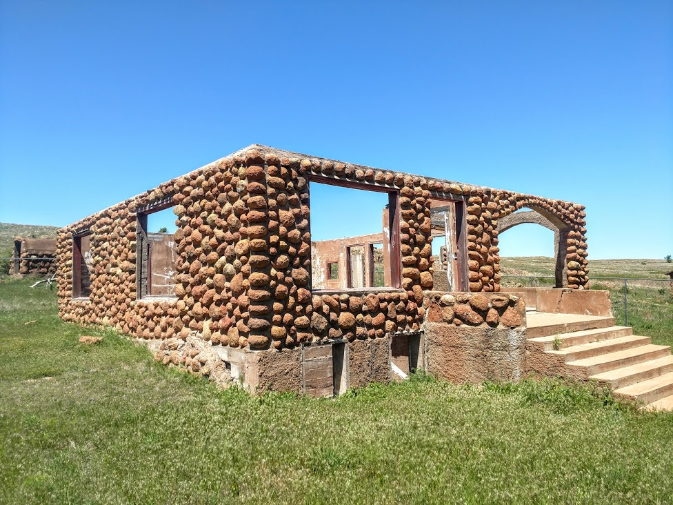
Continuing southwest on US-377 towards I-10, I got off the main road to get to my next geocache. On the corner was this old abandoned house engulfed by nature. It would have been cool to go in and explore, but being on private property that's not such a good idea.


I made it to Red Creek Cemetery (GC1JR4E). Red Creek Cemetery is located in Kimble County. There is no sign identifying the cemetery.There is no historical marker. The land for Red Creek Cemetery was donated to the Community by Frank Latta on 23 May 1896, to be used "for general burial purposes." The first marked grave is that of T. Roy Black (31 August 1897). Frank Latta was laid to rest here 23 March, 1902.

Three young men who made the supreme sacrifice for their country repose here in final rest. Thomas St. Clair lost his life in World War I in Europe; a memorial stone in tribute to Lloyd G. Ivy was placed here following his courageous death in World War II; and John Wilbur Gentry (World War II) rests here. The latter's brother, Lawrence Gentry, lost his life while serving as a military mechanic during the second World conflict. At least eleven veterans of the Civil War - one who served the Union Army and ten who fought for the Confederate cause - are among early settlers buried in Red Creek cemetery.


Continuing south on Ranch Road 385 for a couple of miles, I arrived at my next geocache at the ghost town of Yates, Texas (GC1M4K5). Yates, also known as Yates Crossing, is twelve miles northeast of Junction in eastern Kimble County. It was named by Joseph A. Yates, who opened a post office in June 1907 on his land near a ford of the Llano River on the road from London to Fredericksburg.

Camp meetings were held by early settlers under the live oaks near Yates. Tully J. Lange became Yates's second and final postmaster in June 1909. By the 1920's Yates was the center of a farming community in the Llano River valley. Throughout the decade Yates had a post office, a general store, a gas station, and a population that reached at least fifty-one. The area was advertised as a vacation spot for tourists and campers.

The post office closed in March 1930, and though Yates continues to be shown on maps, its last reported population was ten in 1958. Aside from a few scattered houses, the only thing business related that I saw was this old Kimble Motel sign.


Through Yates on this same spot on the Llano River is the Old Beef Trail Crossing. This Llano River crossing became a main line of the Spring cattle drives from 1867 to the 1880's. Capt C. A. Schreiner and his partners herded cattle on their way to Abilene and Dodge City on the Western Trail; many area cowboys rode with them. Preceded by a trail boss and chuck wagon, as many as 2,000 cattle per herd took half a day to cross. With the air full of dust, local ranchers sat on their own horses watching their own cattle closely to ensure that none of their own herd joined the trail drive. This site later became a vehicle crossing.


Back on US-377 south, I caught this old truck parked by this broken windmill and had to turn around for a photo.


Just down the road was my next roadside geocache near a historical marker (GC1M4J3). Teacup Mountain was named for its peculiar formation. Probably used as a lookout post by both whites and Indians in pioneer days. Near here occurred the Indian killing of pioneer James Bradbury Sr., 1872; and the capture of a wanted man by Lt N.O. Reynolds and four fellow Texas Rangers in 1878.


Named for the soaring Teacup “Mountain” to the west of the site, not much is known of this community other than there were 10 inhabitants at one time and they were served by a single store. The post office “may” have been located in the general store according to The Handbook of Texas. 1947 was the last year anyone bothered to count the number of residents and now there’s no one left to ask.

My last geocache of this trip was at Gentry Creek Cemetery (GC1M4HX). Raleigh Gentry was one of the first settlers in Kimble County, coming to the county in the early 1850's, when he settled on Bear Creek, some five miles with its junction with the North Llano. Here he built a home, erected stables, corrals, outhouses, cleared land and had an ideal paradise from a material standpoint. He prospered, farmed enough land to produce grain for use of his family and his stock, raised cattle, and enough hogs for his family use. In the early 1860's the war clouds gathered and became darker and darker, and finally the able bodied men had to go to war or join the frontier defense. Raleigh Gentry had six stalwart sons; Alan, Lee, Guliford, William, George, and Jack.


His son William married Nancy Frazier, but he answered the call of the Southland and joined the Confederate forces. He left his wife and son John at home, never to return.

In 1862, Raleigh Gentry sold his holdings on Bear Creek and moved some fifteen miles northeast and made a new location, now known as Gentry Creek, but here trouble awaited them. The Indians taking advantage of the lonely situation and the further fact that many of the men folks had gone to fight with the South made repeated raids on Gentry Creek, stealing horses and killing anyone that got in their way. On one occasion, two of the Gentry boys were hunting horses about a mile from home, when they saw the horse herd surrounded by a band of Indians and being driven off. The boys escaped to their home.

In 1867 Allen Gentry and his brother, Lee, went northeast to the Little Saline on a hog hunt and were soon joined by Felix Hale. Their hunt led over the line into Mason County. The part divided, Allen Gentry took one side of the creek, and Felix Hale and Lee another side in their hunt for the hogs. Allen was attacked by the Indians and killed in the very sight of his brother, Lee, who wanted to rush to the defense of his brother but he was told by Felix that it would be suicide and he would lose his own life. Hale and Lee dashed to the first neighbors' and gave the alarm, and parties organized to rescue the body of Allen Gentry and also to pursue the Indians. The body was found and placed on a blanket, and the four corners tied to a long green pole, and in this was the frontiersmen formed a hearse and conveyed the body to the residence of Matthew A. Doyle, the nearest neighbor, a distance of four miles. Here the body was placed in a hack and carried to the Gentry Creek. The body was buried in what developed into the Gentry Creek Cemetery.


Another buried here and worth mentioning is Dan C, Bird, grandson of George C. Kimble, an Alamo hero for whom Kimble County is named. Bird's son, Jack, passed away in California in 1981, and according to his wishes, Jack's cremated remains were scattered above Teacup Mountain that looms in the distance from Gentry Creek Cemetery.

That was it for today. Drove onto I-10 at Junction all the way to Fort Stockton. Thanks for stopping by and we'll see you next week for another tour of Texas.