Showing posts with label movie theater. Show all posts

Sunday, February 4, 2024

2021-06-27: Geocaching and Sightseeing History in Gary and East Chicago Indiana

Hello again and welcome to our adventures. We're winding down our little side road trip while our "new to us" used American Eagle motorhome is almost ready to take delivery. On this day we explored the towns of East Chicago and Gary in northwest Indiana. East Chicago is my fathers hometown and we'll pay a visit to his childhood home. And over in Gary was the childhood home of a world famous celebrity. So join us as we grab some geocaches and take a look around at what remains of this town...


Our first geocache of the day was in South Bend, Indiana for Saint Joseph County. A virtual geocache (GCA525) was located at the LaSalle Landing Park. Unlike a traditional geocache, a virtual geocache doesn't have a container with a log sheet to sign. You typically have to gather some answers at the location and email them to the creator of the virtual cache to get credit for finding it. The coordinates bring you to this stone monument with the depiction of the French explorer LaSalle, the first white man to visit this region, passing from the St Joseph River to the Kankakee River in the late 1600's.


Next door in the now Riverview and Highland Cemeteries is another historical marker recognizing the Council Oak. It was here that three years after his first crossing, LaSalle met with the Miami and Illinois Indians to enter into a treaty to resist the aggressions of the Iroquois. After surviving two lightning strikes, the centuries old oak tree was eventually taken down by a tornado in 1990.


Also located within the cemetery was a famous resident well known in the sports world. Knute Rockne (GC276Q6) emigrated with his parents from Norway to Chicago at the age of five. After graduating high school, he worked at the post office for four years to save enough money to enroll at the University of Notre Dame. He earned All American Honors playing football for Notre Dame in 1913. After a few years playing professionally, he ended up back at Notre Dame. During his 13 years as head coach of the Fighting Irish, he achieved an astounding record of 105 victories, 12 losses, and 5 ties, as well as 3 National Championships. Rockne died in a plane crash in 1931 at the age of 43.


Driving over into Lake County, we arrived in Gary, IN. The first thing I see that I remember hearing about was the U.S. Steel plant. It was where my grandfather worked. Gary Indiana was named after Elbert Gary, a co-founder and longtime chairman of U.S. Steel. When U.S. Steel bought the land to build the factory, they also created the Gary Land Company to design and build a town for their workers. At its peak, the Gary plant was the highest producing steel plant in the world.


Near the entrance to the plant is the EJ&E 765 locomotive (GC1VPVD). The Elgin, Joliet & Eastern train engine was built in 1929 by the Baldwin Locomotive Works in Philadelphia. When the EJ&E railroad switched its fleet to diesel engines, U.S. Steel saved it from being scrapped. It sent it to northern Minnesota's Iron Range, where it moved iron ore and taconite bound for Gary Works and other steel mills. Retired and restored it now sits at a roadside park for all to enjoy.


Turning south down Broadway, we passed some of the abandoned buildings around town. With the 1970's came a declining steel market and massive layoffs. U.S. Steel has laid off nearly 30,000 employees. The population of Gary has gone from 175,000 in 1970 down to 69,000 in 2020. It's turning into a modern day ghost town with an estimated 13,000 abandoned structures around town.

One of those buildings was the Palace Theater. Built in 1925, it featured vaudeville acts, live stage shows, and motion pictures bringing in more than 2000 patrons every weekend. From the very beginning it was one of Gary's most popular entertainment venues. But as the city began to decline so did ticket sales. The final live show was performed on January 3, 1972.


I'm switching the next two stops in order for the story to flow better. Over in East Chicago, Indiana, my father grew up in this house on Vernon Ave. This 3-bedroom, 1-bath, 877 square foot house was built in 1930. My father was born in 1932. Along with his parent, I believe he lived here with his four siblings until he joined the Air Force.


He once told me, after returning from his 50th high school reunion, about this girl that once lived down at the end of the street. Her name was Katherine and she walked with a limp. Going to the same schools, they sometimes were in the same class. When she was 19, she married Joseph Jackson and they moved to this house Gary. Joseph became a crane operator at the steel plant where my grandfather also worked.

Joseph and Katherine had 10 children over the next 16 years. This house built in 1949 was just a 2-bdr, 1-bath, at 867sf would be a bit crowded for this large family. One of those children was international pop superstar Michael Jackson. After the family's "Jackson 5" musical group signed their Motown contract in 1969, Joseph moved the family away from Gary to California.


Again, it wasn't until 50 years after graduation at his high school reunion, while sitting around a table reminiscing with classmates about whatever happened to this person and that person, he learned about the girl who lived down the street.

While sitting at a stoplight in East Chicago, Indiana, this building at the opposite corner caught my attention. The Calumet Trust and Savings Bank was constructed in 1916. From what I could gather on the internet, it was abandoned at one time with a partially collapsed roof and water in the basement. But the outer walls and columns are still intact. If only I could have it lifted and moved somewhere else.


OK, back to heading out of town and picking up more geocaching counties. Taking I-65 south into Newton County, I stopped in the Roselawn Cemetery (GC2BE8R) for our next geocache. I didn't take the time to look around cause I wanted to keep moving.

In Jasper County, the next geocache took us to this old abandoned school house (GC8P79B). It was hard to get a decent photo with all the trees surrounding it. But from what my research has found is that it was called the "Newton Township School" and was built in 1923. It was closed in the early 1960's with the rural school consolidations. I couldn't find the geocache here for the school. But I did find another at a nearby stop sign for the county.


Still moving south on I-65, I was able to find a quick geocache (GC8QDK6) in Benton County as we barely passed through the corner of that county. A mile to the east and we're in White County and finding another quick roadside geocache (GC8QDK3).

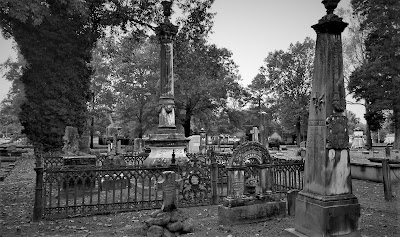
We continued eastbound on US-24 into Carroll County. I stopped at Yeoman Cemetery (GC1FV19) for another geocache. There are just over 1000 internments dating back to 1844.

Our last geocache for the day was at the Davis Cemetery in Cass County (GC3KB5K). The Davis Cemetery has over 3000 internments dating back to 1836. From the Find-A-Grave website: "William was a soldier in the Revolutionary War serving a total of 70 months. He married Lydia Busson in NC, about 1781 and parents of 10 children. They began housekeeping in VA just over the NC line. When the war was over they moved to Warren County, GA, now Columbia County, and lived there 21 or 22 years. The family moved to Preble County, Ohio in 1805 and lived there until 1835 when they moved to White County, IN then to Cass County, IN. Children: Arron, Joseph, Mary, Newberry, William, Jeptha, Mahala, Diadama, Clementine, and Clarrisa."


That's it for today. We still have nearly two hours of driving to get back to Decatur. Thanks for joining us.

To follow along on our travels and keep up with my latest blogs, you may do so here of course by clicking the "Follow" button to the right. And there's also my main website at AwayWeGo.US for the complete index of my traveling adventures going back to 2005. But also by using one or more of your favorite of these social media platforms: FacebookMeWeGabRedditTwitterGETTRInstagram, and TruthSocial. These all link directly to my profiles. Again, please feel free to comment and / or share.

Saturday, April 2, 2022

2020-10-19: Westbound Roadtrip Through Tennessee Civil War History and a Walking Tall Sheriff

Here we are on Day #2 of our westbound roadtrip. Today's trip took us from the Civil War history in Chattanooga through the backroads along the southern route of Tennessee towards Memphis. There's a lot of sightseeing to do, a lot of new geocaches to find, and new counties to add to my map. So climb aboard and let's go for a drive...


With its railroads and riverboats, the city of Chattanooga was a vital transportation center during the Civil War. Both armies recognized its importance. In the late summer and fall of 1863, several key military actions decided the fate of Chattanooga, and helped determine the fate of the Confederacy.

September 18-20: About 10 miles south of Chattanooga near West Chickamauga Creek, Confederate forces defeated the Union Army in a bloody two-day battle. The Federals withdrew to Chattanooga and fortified the city.


September 22 - November 23: Confederates laid siege to the city of Chattanooga to force the Federals to surrender. Confederates occupied positions along the Tennessee River, Missionary Ridge, and Lookout Mountain. In late October, the besieged and hungry Federals managed to open a supply line through Lookout Valley into the city. With fresh troops and supplies, they were ready to fight by late November. On November 23rd, Union troops stormed and captured Orchard Knob, a hill to the east of their defense line in the city.


November 24: Union forces drove the Confederates from their position on Lookout Mountain. Because the mountain was partially shrouded by fog, the action was also called the "Battle Above the Clouds." The following day, Union forces stormed and shattered Confederate unites occupying Missionary Ridge. The siege was broken and Chattanooga became the Federal base from which Maj General William T Sherman would launch his Atlanta campaign in the spring of 1864.


Point Park preserves strategic high ground captured by Union soldiers during the Battle of Lookout Mountain in 1863. Today it is part of Chickamauga and Chattanooga National Military Park and the location of our first virtual geocache (GC41C9). The New York Peace Monument, the centerpiece of the park, symbolizes the reconciliation of the North and South.


Driving down off Lookout Mountain, I made a stop near the base of the Incline Railway for our next virtual geocache (GCMFYC). The Incline Railway up historic Lookout Mountain is the world's steepest passenger railway. The first Incline up Lookout Mountain opened in 1887. It ran from the 38th Street area in St. Elmo to just below the Point. The second Incline, engineered by John Crass, opened November 16, 1895, and is the Incline that is still in operation today. The success of the second Incline was the primary reason that the first Incline closed in 1899.

The incline, 1,972 feet long and rising 1,450 feet, is superbly designed to suit its location. It makes use of a variable grade, ranging up to 72.7 percent near the top, to compensate for the changing weight of the cables as its cars move. One of the cars has flanges on the inside of its wheels, the other on the outside, allowing the cars to pass midway with no moving parts in the track turnouts. Both cars have self-contained emergency brakes. Originally powered by steam, the incline now is driven by two 100-horsepower motors. The latest evolution of the incline cars were just recently installed in March 2020.


Robert Craven built the first house on the hillside of Lookout Mountain in 1856. Seven years later, the Confederate Army occupied Lookout Mountain and Craven's house became the headquarters of Brig. Gen. Edward C. Walthall. On November 24, 1863, Union troops stormed the mountain and pushed the Confederates around to the north end.


When Robert Craven returned to his home after the battle, he found little of his home standing except the basement, the chimney, and the stone dairy. In addition to artillery damage, soldiers had stripped the house looking for souvenirs and firewood. The Cravens rebuilt the house as it currently stands.


Many of the Civil War Battlegrounds have monuments scattered throughout placed by the various states as a memorial to those soldiers who fought and died while representing their states. This particular memorial statue was honoring those soldiers from the state of New York. There is another monument nearby from Illinois which also happens to be a virtual geocache (GC621C).


Finally leaving Chattanooga and Lookout Mountain to continue our roadtrip westbound, we enter the town of Winchester in Franklin County. The town was named after James Winchester (1752 - 1826), who was a soldier in the American Revolution, Speaker of the First Tennessee Legislature, and Brigadier General in the War of 1812. The town of Winchester was created as the Franklin County seat on November 22, 1809.

One of the many monuments and historical markers located within the town square was this one dedicated to the memory of Colonel James Lewis (1756 - 1849). It is also another virtual geocache (GC9366). Col. Lewis served with distinction in the Revolutionary War. He participated in the battles of White Plains, Trenton, Princeton, Brandywine, Germantown, and Yorktown. He erected the first brick house in town and was one of the appointed commissioners for the erection of the first courthouse and jail in Franklin County. There are two other historical accomplishments, but that would give away the answer to the virtual geocache.


The one building that caught my eye the most was the Oldham Theater. Apothecary and druggist shops were originally on this corner from the 1820's thru 1900 with doctors offices upstairs during the 1880's. Later the street level housed the Franklin Grocery and Bakery until the 1930's. The spacious upstairs was hosted large civic gatherings and parties while leased by the Business and Professional Women's Club. The old building was razed in 1949 for construction of a theater.

George E. Oldham, who owned the Rivoli Theatre on the south side of the square, bought this theater from his brother-in-law in 1949 while it was still under construction on the north side of the square as a replacement for his older theater. Unfortunately, George Oldham passed away in September 1949 before the theater officially opened a year later on September 14, 1950 and named in his honor.

Though virtually unchanged in appearance, ownership changed several times and a major renovation began in 2009 and took three years to complete. The upgrade to the two-screen theater included incorporating digital projection equipment, installing surround sound, new curtains and new seats. I think it's pretty cool to see these old theaters still in use.


Continuing our drive west on US-64, the next Tennessee county needed for our geocaching map was Giles County. We stopped in the town of Pulaski at this unique and historical cemetery and memorial park (GC5BQW0). The first cemetery in Pulaski was on the outskirts (at that time) of town in 1817, in a field where interments continued until 1883 when all of the lots were full. Over the years abandoned and nearly forgotten, the cemetery fell into disrepair.

Until in 1969, Pulaski began an urban beautification project here to transform the old cemetery into a city park. The overgrowth was cleared out and headstones were located, identified and cleaned. The headstones were then mounted; the smaller ones in curved structures on the ground and the larger ones into a stone wall along the back of the park. A few monument markers that were still standing after the years were left where they were. Finally, landscaping, paved paths and lighting were added. The interred remains were left in their original locations as it could not be determined who was where except for the few monuments that were still standing.


Moving on into Lawrence County and the town of Lawrenceburg, we find our next two geocaches and a look back into Tennessee history. First was the Garner Mill Earthcache (GC1PPNT). The Garner Mill was used extensively from 1825 to 1849. It was built in 1820, and functioned as a grist mill initially, and then was converted to a water powered sawmill in 1851. Both the dam and the mill were destroyed in the flood of July 13, 1998. The ruins of the foundation still survived the flood, as well as the footings for the dam on the far side of the river. It is listed on the National Registry of Historic Places.


Closer to the center of town was our next geocache at the home of Davy Crockett (GC6K21P). David Crockett lived in this cabin from 1816 to 1822. He was one of the commissioners who laid out the county and selected the site of Lawrenceburg, a colonel in the militia, Justice of the Peace, member of the legislature, and operator of several industries on Shoal Creek during his residence here.


In the Lawrenceburg town square is a statue of Col. Davy Crockett. Born in East Tennessee on August 17, 1786, he gave his life for Texas Liberty and Independence at the Alamo that fateful Sunday morning on March 8, 1836.


Still heading westbound on US-64 picking up new geocaching counties, I make a quick roadside stop for a geocache in Wayne County (GC6B2WF). It was a good thing I stopped for the easy geocache because my target cache was a DNF (GC69K7B). But the good thing is that you never know what you're gonna see while geocaching. Like this homemade rocket ship trike!


Next up was Hardin County in the town of Savanna along the banks of the Tennessee River. There once was a house here built by James Rudd, a pioneer ferry operator, long before the US-64 highway was crossing the river. That house was replaced by another built by David Robinson, whose son-in-law William H. Cherry, improved and enlarged it. During the Civil War, "Cherry Mansion" became the headquarters for Federal Army commander Major General C. F. Smith. When he died he was succeeded by Major General Ulysses S. Grant. Maj. Gen. Wallace died here after being mortally wounded at Shilo.


Unfortunately the geocache had gone missing and I had to DNF it (GC2TVN9). Still needing the county, I stopped a couple blocks away at this small park memorializing the Battle of Shiloh where I found the geocache hidden here (GC1F8PZ).


Just a short drive over to McNair County, and we stop for our next geocache (GC5T5DM) highlighting a local hero and nationally known figure. The movie "Walking Tall" made Sheriff Buford Hayes Pusser a household name. He was born near Finger, Tennessee on December 12, 1937, raised here and graduated from Adamsville High School in 1956. About a year later, Buford moved to Chicago where he worked as a die cutter, attended Worsham College, and wrestled professionally on weekends. While in college he met and married Pauline Mullens.


The saga of Bufford Pusser and the illegal activities on the Tennessee-Mississippi state line began early in 1957, when he was beaten severely at a club in that area. In January 1960, he was arrested for assaulting the owner of a club on the Mississippi side of the3 state line. Bufford received a verdict of innocent at a trial held in Corinth, MS.

Buford's career in law enforcement began when he was appointed Chief-of-Police of Adamsville in 1962. He was later elected Constable and then Sheriff of McNairy County, serving three terms. During his first year as Sheriff, Buford was stabbed on several occasions and along with his deputies raided over forty-two moonshine operations. In 1966 he was forced to shoot in self-defense the operator of a motel on the state line where he had gone to investigate a robbery. In January of 1967, Buford was shot at point blank range four times by two men he had stopped in the state line area. The most deplorable episode in his career began one early morning on August 12, 1967 when he, accompanied by his wife, was enroute to answer a call. They were ambushed on New Hope Road, killing Pauline with Buford barely surviving the ordeal being severely wounded himself. In December 1968, Buford answered a call for help and a known murderer opened fire on him, leaving him no choice but to shoot and kill him in self-defense.


Sheriff Buford was selected in 1970, by the Jaycees, as one of Tennessee's "Outstanding Young Men of the Year." He had signed a movie contract to depict himself in a sequel to the movie "Walking Tall" when he was suddenly killed in an automobile accident on Highway 64, west of Adamsville, on August 24, 1974.

Bufford Pusser's experiences have inspired seven movies, five books, a television series, several magazine articles, and a Colt Commemorative Limited Edition handgun, all depicting the life of a man who "Walked Tall."


Our last geocaching county of the day is for Hardeman County and the town of Bolivar, Tennessee. It was a quick park and grab geocache to claim a find in the county (GC4WGKP).

From there it was just a couple of blocks south to the Polk Cemetery. Even though there's wasn't a geocache there, it was historical and worthy of a stop. The land was acquired by James K. Polk Jr. and others on October 23, 1845 as a family cemetery for the descendants of Ezekial Polk. Colonel Polk, the patriarch of the Polk family in Tennessee, was the grandfather of President James Knox Polk. The elder Polk was instrumental in framing the Mecklenburg Declaration of Independence and served in the Revolutionary War. He lived in Maury County before settling in Hardeman County.


That's all for today. We continue heading west on US-64 and find a place to stay for the night just outside of Memphis. I'm thinking a trip to Elvis's Graceland in the morning might be a plan. I hope you return to see the outcome. Until then...

To follow along on our travels and keep up with my latest blogs, you may do so here of course. But also by using you favorite of these social media platforms: FacebookMeWeGabRedditParlorTwitterRVillageGETTR and Instagram. These all link directly to my profile. Again, please feel free to comment and / or share.

Saturday, February 12, 2022

2020-09-20: Walking Around the Historical Augusta, Georgia and Finding a Few Geocaches

On this second day of our roadtrip, we started out in Augusta, Georgia. We've passed through this city many times but never really taken the time to explore it. So this morning before we continued the rest of our drive up to the RV park in North Carolina, we spent some time checking out the historical riverfront area of Augusta. So let's take a walk through this historic community.

Founded in 1736 on the western bank of the Savannah River, Augusta, Georgia became the second town of the 13th British colony. General James Edward Oglethorpe, the colony’s founder, ordered the settlement and chose its location at the head of navigation of the Savannah River below the shoals created by the fall line. Oglethorpe’s vision was to establish an interior trading post for purchasing furs and other commodities from Native Americans to compete with New Savannah Town, a small outpost on the South Carolina side of the river.


Augusta thrived as a trading post from the beginning, with several of the South Carolina traders moving their base of operations to the new settlement. By 1739 a fort was completed, and the official surveyor of the colony, Noble Jones, laid out the town. Its colonial plan was similar, but not as elaborate as the one used in Savannah. Augusta’s plan focused on one large square or plaza and was four streets deep and three streets wide. Fort Augusta was adjacent to the 40 town lots on the west side near the river. Augusta named two of its original streets for Georgia’s colonial governors: Reynolds Street for John Reynolds, and Ellis Street for Henry Ellis. These streets are still prominent features of the Downtown Augusta, Broad Street, and Pinched Gut Historic Districts.


As traders populated the town, they brought their wives and began to have children. The desire for a more civilized atmosphere dictated the need for a church. As a British colony, Georgia petitioned the Society for the Propagation of the Gospel for a minister after constructing a church building in 1749. The first minister, the Reverend Jonathan Copp, arrived in 1751 and began conducting services according to the rites of the Church of England. After Georgia’s division into parishes in 1756, the Augusta District fell into St. Paul’s Parish, and the Augusta church became known as St. Paul’s Church (GC7B87M).


The brick pavers above layout the site of the first church in Augusta in 1749. The first church was destroyed during the French and Indian War (1754-1763). When rebuilt, the church became part of Fort Cornwallis until its destruction in 1781, in the Second Siege of Augusta, during the Revolutionary War. The Trustees of the Academy of Richmond rebuilt the third church on this property in 1789. This church was where the First Presbyterian Church was founded in 1804. Later, the congregation would build a new church on Telfair Street and move in, in 1812. The Episcopalian congregation would regain ownership in 1818. Robert Lund designed a new church which was completed and consecrated in 1821. The congregation grew and built a church school in 1843, with an orphanage added in the 1850's. During the Civil War, the property served as a hospital for the Confederacy.


The Great Augusta Fire of 1916 burned the fourth church, along with over 30 blocks of downtown Augusta and Olde Town. Fortunately, they were able to save some of the church furniture. Services continued to be held under a tent and at the courthouse until a new home could be built. The fifth church is the one we see here today. The exterior was designed to resemble church number four, Federal Style. The interior was redesigned in the Georgian style. The baptismal font is from the first church and many items rescued from the fire, from the fourth church, are still in use here today.

According to the Find-A-Grave website, there are 166 burials scattered about on the St Paul's Church graveyard (GC1PA14) dating back to 1754. The cemetery is still used today though not as often as I'm sure even a small burial plot is prime real estate and very expensive.


After the Revolution Augusta became the temporary capital of the new state of Georgia between 1786 and 1795, and many of the leaders of the government moved to the town. One of the most notable was George Walton, a Signer of the Declaration of Independence, who built his home, Meadow Garden, on what was then the outskirts of town. The other of Georgia's Declaration of Independence signers, Colonel William Few Jr, was buried at the St Paul's Cemetery in 1828.


The town continued to grow in size and population governed by a group of Trustees of the Academy of Richmond County. In 1791 they added Telfair Street, named for Georgia Governor Edward Telfair. Telfair Street today is another major artery through the Augusta Downtown and Pinched Gut Historic Districts. President George Washington’s visit in 1791 was a highlight of this period. Legend has it that Augustans planted the large ginkgo tree in his honor at the proposed site of the Richmond County Courthouse, constructed in 1801 and now known as the Old Government House. The Trustees of the Academy built a new school building in 1802, the old Academy of Richmond County.

As Georgia expanded westward and the states of Alabama and Mississippi attracted many of its prosperous planters, Augusta’s economy began to stagnate. The Charleston and Hamburg Railroad in South Carolina reached a point directly across the Savannah River from the heart of downtown Augusta in 1832. In 1833 the Georgia Railroad, chartered in Athens, Georgia, began building westward from Augusta toward a yet unnamed settlement that would eventually become Atlanta.


The railroad did not ensure Augusta’s future, as the tug on Americans to move westward grew ever stronger, but other factors had a positive impact on the city. Spurred by the invention in 1793 of the cotton gin, local farmers grew upland cotton in the surrounding countryside making Augusta the center of a large inland cotton market.

Augusta served as a major center of the Confederacy, providing cotton goods, shoes, guns, munitions, food, and many other commodities. In addition, the city was a religious center of the South hosting meetings for the formation of both the Protestant Episcopal Church in the Confederate States of America at St. Paul’s Church, and the Presbyterian Church in the Confederate States at First Presbyterian Church. The meeting took place there at the invitation of its pastor, Reverend Joseph Ruggles Wilson, who lived with his family in the parsonage, the Woodrow Wilson Boyhood Home.


Next door to the future President’s home was the parsonage of First Christian Church, home of future U.S. Supreme Court Justice Joseph R. Lamar. Wilson and Lamar, both sons of prominent Augusta pastors, were best friends as children.


Following the Civil War, Augusta’s economy struggled but rebounded with the enlargement and expansion of the Augusta Canal in 1875. Several large new cotton mills were built along its banks. As the old city continued to expand, most religious denominations realized the need to establish a second congregation in the western end of the city, and often a third or fourth in the suburban areas. With the expansion of the Augusta Canal, the city was once again a thriving center of a cotton economy. Cotton warehouses lined Reynolds Street between St. Paul’s Church on the east and 9th Street on the west.


Augusta's Imperial Theatre began in 1917 as a vaudeville showcase named The Wells Theatre. On Sunday, October 6, 1918, over 3,000 cases of Spanish Flu were reported. With the death of 52 servicemen from nearby Fort Gordon, the city announced the closure of all public venues, including the theatre. The quarantine began October 7, and during this time Jake Wells encountered great financial difficulties. He sold The Wells to Lynch Enterprises. On November 27, 1918, shortly after the sell, the quarantine is lifted and the theatre opened two weeks later. The Wells Theatre's was soon changed to The Imperial Theatre. Throughout the early 1900's the theatre continued to provide the city of Augusta and the surrounding area with great entertainment. In 1929, as vaudevillian acts decreased in popularity and motion pictures enjoyed meteoric success, Miller decided to renovate the Imperial into a full-time movie house in the popular art deco style. Decades later due to the decline of the downtown area, the Imperial continued as a film theatre until it closed in 1981. In 1985 it was recognized for its architectural significance and reopened as a performing arts venue with the help of local performing arts groups like the Augusta Ballet and the Augusta Players.


Saw this sign on another business in the historic district. I'm don't think there is a long history to research here, but I liked the appropriate name for the bar and thought I'd share it with you.


In 2005, a statue was dedicated in the historic district and James Brown Plaza in honor of the "Godfather of Soul" (GC11BDX). Born in South Carolina in 1933, the family moved to Augusta when he was five years old. He began singing in talent shows as a young child, first appearing at Augusta's Lenox Theater in 1944. As a singer, songwriter, musician and one-of-a-kind performer, James Brown has thrilled millions around the world with his hit recordings and electrifying performances. 


While there is much more that can be said of Augusta's history and many more places to see, we still have a long drive ahead of us to the RV park in North Carolina. So let us get back on the road for now. Until the next time...

To follow along on our travels and keep up with my latest blogs, you may do so here of course. But also by using you favorite of these social media platforms: FacebookMeWeGabRedditParlorTwitterRVillageGETTR and Instagram. These all link directly to my profile. Again, please feel free to comment and / or share.

Saturday, September 18, 2021

2020-03-28: Roadtrip Day 2: Driving Through Louisiana and into Mississippi on the way to Georgia

One thing I like about driving the backroads and byways on a roadtrip is that you never know what you're gonna see around the next corner. Whether it be a scenic overlook, a piece of history, or just something so crazy funny that it requires you to turn around for another look and capture it with a photo. Todays drive had something for everyone. So there's a lot to see now let's get rolling...


After waking up early in Shreveport, Louisiana and going for breakfast, I grabbed a quick urban geocache that was close by (GC7G3XD).

On the way to my next geocache, I passed this old church building. The sign out front said Antioch Baptist Church. It doesn't look like this facility has been used in many years. In preparing to write this blog post, I spent a few hours trying to research some history but kept coming up empty. I can't find anything on this old church.


So I arrive at the next geocache (GC1XVN5) which was just a simple and quick roadside cache to add a new county into the finds list. Upon arriving though and seeing the sign, I guess they take their "No Trespassing" pretty serious! I found the cache quick and got myself outta there!


After another quick roadside geocache (GC7QJ0X), I passed by these two old abandoned houses that were just slowly decaying and falling apart. I'm always curious as to what happened with these homes...


...especially this second house. It looked like it would have been a house to envy back in the day. Come to find out that it is called the Garland House. It was built in 1902 and placed on the National Register in 1994. It is a Queen Anne Revival design. This one is in great need of reviving.


Continuing eastbound on Hwy 2, the next geocache was at the Corney Creek Calaboose (GC26WWQ). A calaboose is a tiny jail. This calaboose in the town of Bernice, LA was built in 1902. The town of Bernice was established in 1899 as a sawmill town after Captain C.C. Henderson built the Arkansas Southern Railroad.


This next stop was rather sad. On the north side of Bernice is the old Mount Olive Cemetery (GC26HGV). This neglected forgotten cemetery contains between 40-50 burials dating as far back as 1860. However, I only saw less than 10 headstones in all this overgrowth. Some of the locals need to come out here and clean this cemetery up.


Still following State Highway 2 eastbound to pickup caches in these northern parishes, my next stop is an earthcache and a traditional cache at Elgin Springs (GC20PEP, GCJ4CV). It would have been a quick roadside stop, but I had trouble finding the traditional cache and had to DNF it. As for the earthcache, I got what I needed to answer the questions to log a find. No photos here since it really isn't much to see here. Not exactly what you picture in your mind when you think of natural springs.

To make up for the lack of photos at the springs, I was able to capture two great old car pics as an unexpected surprise. This one below of a 1920's sedan just rusting away among the trees along the highway. And the more humorous one I opened with at the top of the page.


These next two were just quick roadside park and grabs (GC73X26, GC23FEX).

Our next stop was a really cool piece of history in Oak Grove, LA. The Fiske Theatre (GC29ZM9) was first opened in April 1928 and at that time was the premier state of the art movie cinemas in Northeast Louisiana. It was owned and operated by the late Donald Fiske of Oak Grove. The Fiske Theatre was a two level cinema with a first floor that seated 500 people and a balcony that seats 250, as well as a cry room located on the back of the first floor for mothers with small children.

The Fiske Theatre was rebuilt in 1950 and relocated from just down main street to it's current location, and was operated continuously by the Fiske Family until 1987 as a first run cinema. It looks just about the same now as it did in the 1950's. In 1987 as Mr. Fiske's health began to fail him, the theatre was donated to the West Carroll Chamber of Commerce where it has been used mainly for gospel music concerts and other community events since then.


The theatre is in very good condition thanks to the hard work of the chamber volunteers and numerous grants for upkeep from the Louisiana State Legislature. After a two-month renovation period in the fall of 2008, the Fiske Theatre returned as a first run movie theatre on December 15, 2008 with a showing of "Fireproof". The theater is run by volunteers who share a passion for the preservation of this historic movie theater. Any proceeds go to the upkeep of this terrific piece of Americana. At the time of our visit to the Fiske Theatre was closed as the pandemic was just beginning to spread.

Next up was a geocache at the Cotton Museum (GC1CN8D). The Louisiana State Cotton Museum in Lake Providence provides a great introduction to one of Louisiana’s major agricultural crops, and certainly the one for which the Delta area is best known. Its main gallery features an extensive set of interpretive exhibits, including life-sized dioramas, farming equipment, a re-created juke joint and more, all packed into a replica gin house (where cotton fiber was ginned, or separated from the seed).


Also on the grounds of the museum is an impressive array of old plantation buildings, such as a sharecropper’s cabin, a schoolhouse, and a small chapel. And of course an old outhouse where the cache was hidden inside the business deposit area.


One more quick roadside geocache in the town of Transylvania (GC1CN8Z) along with the above museum are two caches for the East Carroll Parish completing the northern counties in Louisiana.


Now we face the Mississippi River and need to cross over. Most would go south to I-20 and cross over into Vicksburg. Been there, done that, and already have those counties. So I turn north into Arkansas. I stop for two quick geocaches along US-65 for Chicot County (GC2QTFTGC2R0NT). Then took US-278 to cross the great river.

Passing through Greenville, Mississippi, I spotted this riverboat and stopped for a quick photo.


The next few stops were part of the Mississippi Blues Trail. In the small town of Holly Ridge you'll find the final resting place of three bluesmen (GC15CJ1). Charley Patton (1891 - 1934) was the most influencing figure in the pioneering era of the Delta Blues. He helped define not only the musical genre but also the image and lifestyle of the rambling Mississippi bluesman. He roamed the Delta using Dockery as his most recent base, and lived his final year in Holly Ridge. Patton and blues singers Willie James Foster (1921 - 2000) and Asie Payton (1937 - 1997) are buried in the Holly Ridge Cemetery.

In the next town of Indianola, MS, I found the B.B. King Corner (GC4MZKG). It was on this corner, when Riley B. King was just a young man of 17, that locals first heard the musician destined to become the "King of the Blues." On June 6, 1980, BB King placed his handprints and signature here in the sidewalk to the left of the guitar.


Our last geocache of the day was at the Indianola City Cemetery (GC30XD5). This is a large well maintained cemetery with over 3,000 interments.


We ended the day in Greenwood, MS, a little more than 300 miles after we started. I picked up some new counties and parishes to fill the map. And we saw a lot of great roadside attractions, planned and a few surprises too. Tomorrow is another day and we still have a long way to go and a lot to see. I hope you come back and join us. See ya next time...

To follow along on our travels and keep up with my latest blogs, you may do so here of course. But also by using you favorite of these social media platforms: FacebookMeWeGabRedditParlorTwitter, and Instagram. These all link directly to my profile. Again, please feel free to comment and / or share.