Showing posts with label cannon. Show all posts

Saturday, April 2, 2022

2020-10-19: Westbound Roadtrip Through Tennessee Civil War History and a Walking Tall Sheriff

Here we are on Day #2 of our westbound roadtrip. Today's trip took us from the Civil War history in Chattanooga through the backroads along the southern route of Tennessee towards Memphis. There's a lot of sightseeing to do, a lot of new geocaches to find, and new counties to add to my map. So climb aboard and let's go for a drive...


With its railroads and riverboats, the city of Chattanooga was a vital transportation center during the Civil War. Both armies recognized its importance. In the late summer and fall of 1863, several key military actions decided the fate of Chattanooga, and helped determine the fate of the Confederacy.

September 18-20: About 10 miles south of Chattanooga near West Chickamauga Creek, Confederate forces defeated the Union Army in a bloody two-day battle. The Federals withdrew to Chattanooga and fortified the city.


September 22 - November 23: Confederates laid siege to the city of Chattanooga to force the Federals to surrender. Confederates occupied positions along the Tennessee River, Missionary Ridge, and Lookout Mountain. In late October, the besieged and hungry Federals managed to open a supply line through Lookout Valley into the city. With fresh troops and supplies, they were ready to fight by late November. On November 23rd, Union troops stormed and captured Orchard Knob, a hill to the east of their defense line in the city.


November 24: Union forces drove the Confederates from their position on Lookout Mountain. Because the mountain was partially shrouded by fog, the action was also called the "Battle Above the Clouds." The following day, Union forces stormed and shattered Confederate unites occupying Missionary Ridge. The siege was broken and Chattanooga became the Federal base from which Maj General William T Sherman would launch his Atlanta campaign in the spring of 1864.


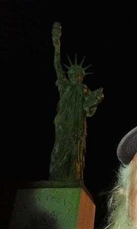
Point Park preserves strategic high ground captured by Union soldiers during the Battle of Lookout Mountain in 1863. Today it is part of Chickamauga and Chattanooga National Military Park and the location of our first virtual geocache (GC41C9). The New York Peace Monument, the centerpiece of the park, symbolizes the reconciliation of the North and South.


Driving down off Lookout Mountain, I made a stop near the base of the Incline Railway for our next virtual geocache (GCMFYC). The Incline Railway up historic Lookout Mountain is the world's steepest passenger railway. The first Incline up Lookout Mountain opened in 1887. It ran from the 38th Street area in St. Elmo to just below the Point. The second Incline, engineered by John Crass, opened November 16, 1895, and is the Incline that is still in operation today. The success of the second Incline was the primary reason that the first Incline closed in 1899.

The incline, 1,972 feet long and rising 1,450 feet, is superbly designed to suit its location. It makes use of a variable grade, ranging up to 72.7 percent near the top, to compensate for the changing weight of the cables as its cars move. One of the cars has flanges on the inside of its wheels, the other on the outside, allowing the cars to pass midway with no moving parts in the track turnouts. Both cars have self-contained emergency brakes. Originally powered by steam, the incline now is driven by two 100-horsepower motors. The latest evolution of the incline cars were just recently installed in March 2020.


Robert Craven built the first house on the hillside of Lookout Mountain in 1856. Seven years later, the Confederate Army occupied Lookout Mountain and Craven's house became the headquarters of Brig. Gen. Edward C. Walthall. On November 24, 1863, Union troops stormed the mountain and pushed the Confederates around to the north end.


When Robert Craven returned to his home after the battle, he found little of his home standing except the basement, the chimney, and the stone dairy. In addition to artillery damage, soldiers had stripped the house looking for souvenirs and firewood. The Cravens rebuilt the house as it currently stands.


Many of the Civil War Battlegrounds have monuments scattered throughout placed by the various states as a memorial to those soldiers who fought and died while representing their states. This particular memorial statue was honoring those soldiers from the state of New York. There is another monument nearby from Illinois which also happens to be a virtual geocache (GC621C).


Finally leaving Chattanooga and Lookout Mountain to continue our roadtrip westbound, we enter the town of Winchester in Franklin County. The town was named after James Winchester (1752 - 1826), who was a soldier in the American Revolution, Speaker of the First Tennessee Legislature, and Brigadier General in the War of 1812. The town of Winchester was created as the Franklin County seat on November 22, 1809.

One of the many monuments and historical markers located within the town square was this one dedicated to the memory of Colonel James Lewis (1756 - 1849). It is also another virtual geocache (GC9366). Col. Lewis served with distinction in the Revolutionary War. He participated in the battles of White Plains, Trenton, Princeton, Brandywine, Germantown, and Yorktown. He erected the first brick house in town and was one of the appointed commissioners for the erection of the first courthouse and jail in Franklin County. There are two other historical accomplishments, but that would give away the answer to the virtual geocache.


The one building that caught my eye the most was the Oldham Theater. Apothecary and druggist shops were originally on this corner from the 1820's thru 1900 with doctors offices upstairs during the 1880's. Later the street level housed the Franklin Grocery and Bakery until the 1930's. The spacious upstairs was hosted large civic gatherings and parties while leased by the Business and Professional Women's Club. The old building was razed in 1949 for construction of a theater.

George E. Oldham, who owned the Rivoli Theatre on the south side of the square, bought this theater from his brother-in-law in 1949 while it was still under construction on the north side of the square as a replacement for his older theater. Unfortunately, George Oldham passed away in September 1949 before the theater officially opened a year later on September 14, 1950 and named in his honor.

Though virtually unchanged in appearance, ownership changed several times and a major renovation began in 2009 and took three years to complete. The upgrade to the two-screen theater included incorporating digital projection equipment, installing surround sound, new curtains and new seats. I think it's pretty cool to see these old theaters still in use.


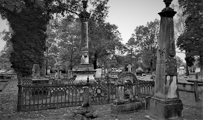
Continuing our drive west on US-64, the next Tennessee county needed for our geocaching map was Giles County. We stopped in the town of Pulaski at this unique and historical cemetery and memorial park (GC5BQW0). The first cemetery in Pulaski was on the outskirts (at that time) of town in 1817, in a field where interments continued until 1883 when all of the lots were full. Over the years abandoned and nearly forgotten, the cemetery fell into disrepair.

Until in 1969, Pulaski began an urban beautification project here to transform the old cemetery into a city park. The overgrowth was cleared out and headstones were located, identified and cleaned. The headstones were then mounted; the smaller ones in curved structures on the ground and the larger ones into a stone wall along the back of the park. A few monument markers that were still standing after the years were left where they were. Finally, landscaping, paved paths and lighting were added. The interred remains were left in their original locations as it could not be determined who was where except for the few monuments that were still standing.


Moving on into Lawrence County and the town of Lawrenceburg, we find our next two geocaches and a look back into Tennessee history. First was the Garner Mill Earthcache (GC1PPNT). The Garner Mill was used extensively from 1825 to 1849. It was built in 1820, and functioned as a grist mill initially, and then was converted to a water powered sawmill in 1851. Both the dam and the mill were destroyed in the flood of July 13, 1998. The ruins of the foundation still survived the flood, as well as the footings for the dam on the far side of the river. It is listed on the National Registry of Historic Places.


Closer to the center of town was our next geocache at the home of Davy Crockett (GC6K21P). David Crockett lived in this cabin from 1816 to 1822. He was one of the commissioners who laid out the county and selected the site of Lawrenceburg, a colonel in the militia, Justice of the Peace, member of the legislature, and operator of several industries on Shoal Creek during his residence here.


In the Lawrenceburg town square is a statue of Col. Davy Crockett. Born in East Tennessee on August 17, 1786, he gave his life for Texas Liberty and Independence at the Alamo that fateful Sunday morning on March 8, 1836.


Still heading westbound on US-64 picking up new geocaching counties, I make a quick roadside stop for a geocache in Wayne County (GC6B2WF). It was a good thing I stopped for the easy geocache because my target cache was a DNF (GC69K7B). But the good thing is that you never know what you're gonna see while geocaching. Like this homemade rocket ship trike!


Next up was Hardin County in the town of Savanna along the banks of the Tennessee River. There once was a house here built by James Rudd, a pioneer ferry operator, long before the US-64 highway was crossing the river. That house was replaced by another built by David Robinson, whose son-in-law William H. Cherry, improved and enlarged it. During the Civil War, "Cherry Mansion" became the headquarters for Federal Army commander Major General C. F. Smith. When he died he was succeeded by Major General Ulysses S. Grant. Maj. Gen. Wallace died here after being mortally wounded at Shilo.


Unfortunately the geocache had gone missing and I had to DNF it (GC2TVN9). Still needing the county, I stopped a couple blocks away at this small park memorializing the Battle of Shiloh where I found the geocache hidden here (GC1F8PZ).


Just a short drive over to McNair County, and we stop for our next geocache (GC5T5DM) highlighting a local hero and nationally known figure. The movie "Walking Tall" made Sheriff Buford Hayes Pusser a household name. He was born near Finger, Tennessee on December 12, 1937, raised here and graduated from Adamsville High School in 1956. About a year later, Buford moved to Chicago where he worked as a die cutter, attended Worsham College, and wrestled professionally on weekends. While in college he met and married Pauline Mullens.


The saga of Bufford Pusser and the illegal activities on the Tennessee-Mississippi state line began early in 1957, when he was beaten severely at a club in that area. In January 1960, he was arrested for assaulting the owner of a club on the Mississippi side of the3 state line. Bufford received a verdict of innocent at a trial held in Corinth, MS.

Buford's career in law enforcement began when he was appointed Chief-of-Police of Adamsville in 1962. He was later elected Constable and then Sheriff of McNairy County, serving three terms. During his first year as Sheriff, Buford was stabbed on several occasions and along with his deputies raided over forty-two moonshine operations. In 1966 he was forced to shoot in self-defense the operator of a motel on the state line where he had gone to investigate a robbery. In January of 1967, Buford was shot at point blank range four times by two men he had stopped in the state line area. The most deplorable episode in his career began one early morning on August 12, 1967 when he, accompanied by his wife, was enroute to answer a call. They were ambushed on New Hope Road, killing Pauline with Buford barely surviving the ordeal being severely wounded himself. In December 1968, Buford answered a call for help and a known murderer opened fire on him, leaving him no choice but to shoot and kill him in self-defense.


Sheriff Buford was selected in 1970, by the Jaycees, as one of Tennessee's "Outstanding Young Men of the Year." He had signed a movie contract to depict himself in a sequel to the movie "Walking Tall" when he was suddenly killed in an automobile accident on Highway 64, west of Adamsville, on August 24, 1974.

Bufford Pusser's experiences have inspired seven movies, five books, a television series, several magazine articles, and a Colt Commemorative Limited Edition handgun, all depicting the life of a man who "Walked Tall."


Our last geocaching county of the day is for Hardeman County and the town of Bolivar, Tennessee. It was a quick park and grab geocache to claim a find in the county (GC4WGKP).

From there it was just a couple of blocks south to the Polk Cemetery. Even though there's wasn't a geocache there, it was historical and worthy of a stop. The land was acquired by James K. Polk Jr. and others on October 23, 1845 as a family cemetery for the descendants of Ezekial Polk. Colonel Polk, the patriarch of the Polk family in Tennessee, was the grandfather of President James Knox Polk. The elder Polk was instrumental in framing the Mecklenburg Declaration of Independence and served in the Revolutionary War. He lived in Maury County before settling in Hardeman County.


That's all for today. We continue heading west on US-64 and find a place to stay for the night just outside of Memphis. I'm thinking a trip to Elvis's Graceland in the morning might be a plan. I hope you return to see the outcome. Until then...

To follow along on our travels and keep up with my latest blogs, you may do so here of course. But also by using you favorite of these social media platforms: FacebookMeWeGabRedditParlorTwitterRVillageGETTR and Instagram. These all link directly to my profile. Again, please feel free to comment and / or share.

Saturday, February 27, 2021

2019-05-19: Caching Counties in North Carolina and Visiting Civil War History

Welcome back to another one of AwayWeGo's Geocaching Adventure stories. After working all week here in North Carolina, on this Sunday day off it's time to go geocaching and pick up some new counties to add to my geocaching county map. So as I look down this trail into what may be ahead, are you ready to go along for the ride? Are you just as curious? The GeoJeep passenger seat is open. Let's go on a roadtrip and see what awaits us.


Starting out with breakfast at Hardies in Washington, NC, I drive north on US-17 up to Old Ford on the way towards my first geocache. Before I get to the geocache, I see this old church building to my right across the street from the Old Ford Church of Christ on my left. I quickly pull over and take a few dozen photos. 

Now I can't just leave it at that and keep you interested. So I start doing some research. Not much on the web via normal searches. But I did find an old newspaper article from November 11, 1928 which describes a centennial celebration. The Old Ford Church was at first a Calvinistic Baptist Church founded by Joseph D. Biggs and Jeremiah Leggett in October 1828 with 20 members. Between 1831 to 1833, Pastor Leggett swayed them towards the Church of Christ. As the membership grew over the years, they outgrew this building.


Further down NC-171, I also spot this old 1956 GMC Pickup Truck just rusting away in somebody's yard. That would be so cool to restore or turn into a radical resto-mod. If I only had the time or money. Well mostly the money to be able to do such a thing.


Now I finally stop for a quick roadside cache (GC42NQV) down a country road before arriving at my target geocache for Washington County. The Roanoke River Lighthouse (GC10RGW) in Plymouth is actually a replica of the lighthouse that used to be at the mouth of the Roanoke River in the Albemarle Sound in 1866.


There's also a boat museum next door with a few old wooden boats used on the river.


Continuing down the river front in Plymouth, I arrive at the next geocache and Civil War history. The C.S.S. Albemarle (GC5NEHF) was contracted by the Confederate Navy in 1863. Gilbert Elliot, a 19-year-old engineer, constructed an ironclad gunboat designed by John L. Porter, the navy's chief architect. Elliot built the vessel at Edwards Ferry on the Roanoke River, 60 miles upstream from Plymouth, where his "shipyard" was Peter Smith's cornfield. It took more than a year to construct the C.S.S. Albemarle , which was 158 feet long and 35 feet wide, and topped with a 60 foot long casemate sheathed with two layers of two inch thick iron plates. Inside the casemate, two large Brooke Rifled cannons could fire hundred pound shells. An 18-foot long white oak ram, also sheathed with iron plates, extended from Albemarle's bow to puncture the sides of wooden vessels and sink them.


Albemarle saw first action on April 19, 1864, during the Battle of Plymouth, when it rammed and sank U.S.S. Southfield. It also indirectly caused the death of the Federal Fleet's Commander, Charles W. Flusser. A shell fired from Flusser's ship, U.S.S. Miami, at Albemarle bounced off the iron plating back onto the Miami and exploded, killing Flusser, who was standing next to the cannon that had fired the shell.

On May 5th, in an engagement in Albemarle Sound, the Albemarle engaged seven US gunboats. Despite being outgunned 60 cannons to two, outshelled 557 to 27, and rammed, the Albemarle escaped destruction. The ironclad was finally torpedoed (blown up with a mine on the end of a wooden spar) on October 27, by a motor launch commanded by Lt William B Cushing, and sank. The Federals recaptured Plymouth on October 31st.

Outside the Port O' Plymouth museum sits a replica of the 6.4 inch Brooke Rifled Cannon. Developed by Commander John Mercer Brooke (CSA), who served as Chief, Department of Ordnance and Hydrography. While closely resembling the Parrot Gun used by the Union, the Brooke Rifle is considered to be the finest cannon on both sides of the war. The fact that the bore had rifling, or spiraled grooves in the barrel to spin the projectile, made it extremely accurate. While the two original cannons from the Albemarle are on display at the Norfolk Navy Base, inside the Plymouth museum are some of the original shells fired from the Albemarle.


Entering into Bertie County, I drive over to the north side of the Cashie River to catch a ride on the Sans Souci Ferry. There was a virtual geocache halfway across. But the ferry was closed and I wasn't able to get the find. But there was a recently placed traditional cache (GC85629) on the north bank of the river and I was able to retrieve and sign the log for it.

Continuing may way around to the north side of Albemarle Sound, I make my next stop at the Beaver Hill Cemetery (GC84AZ7) in Chowan County. The geocache highlighted the sadness and struggles of the Littlejohn Family living in the late 1700's. According to the Find-A-Grave website, the cemetery dates back to 1778 and Catherine Littlejohn who lived only 6 days. Only four of the twelve Littlejohn children lived beyond age 20. And Catherine was just one of four Littlejohn children who didn't even make it to see their first birthday.

There are now more than 6000 permanent residents in the Beaver Hill Cemetery. This angel statue was located within the cemetery and looks over those here.


Across the creek from the southeast corner of the Beaver Hill Cemetery, is the Providence Burial Ground (GC84E7C). From the plaque: "Established in the late 18th century, this African-American cemetery is the final resting place for free blacks, slaves, and emancipated people buried here through the late 19th century. Among those interred here are several family members of Thomas Barnswell, a free black property owner; Molly Horniblow, a free black businesswoman and grandmother of author and abolitionist Harriet Jacobs; and Jonathan Overton, a free black veteran of the Revolutionary War, a Private in the 10th NC Regiment of the Continental Line." (2001) There wasn't much to see here anymore. Just an empty lot with a couple headstones remaining and a few place markers.

Continuing on US-17 east, the next county over was Perquimans County. Located in the town of Hertford along the banks of the Perquimans River is a virtual geocache at a historical house (GC4740). The 1730 Newbold-White House is one of North Carolina's oldest examples of colonial architecture. The house served as an important meeting place for the state's Quaker congregations as well as a center for governmental courts and assemblies.

A land grant from the Lords Proprietors to Joseph Scott for 640 acres included this tract of land and house site. Personal journals of Quaker missionary George Fox describe a meeting with Joseph Scott and his neighbors at his home in 1672. Later Scott, along with his family and neighbors, established their own Quaker congregation. Following the death of his first wife, Scott married Mary Hudson in 1683. Until her death in 1692, Mary Hudson Scott opened her home as a meeting place for Quaker congregations.

James Coles and his wife, Mary, bought the land in 1703. The property was sold at auction in 1726 and was bought by Abraham Saunders, a Quaker and planter. Saunders most likely built the one-and-one-half-story brick dwelling that later came to be known as the Newbold-White House. The name Newbold-White derived from its last two private owners, Jim Woodward White and John Henry Newbold. The Perquimans County Restoration Association, Inc., purchased the house in 1973 with the intention of preserving it as a historic site.


One more northeast county to go and I wasn't going to pass up without it. I did that back in Texas and had to take a weekend to go all the way back to the north corner to finish the state. Turned out on US-158 east into Currituck County. There were two caches on my target and was looking forward to going after them cause they were on a 4x4 Jeep trail. (GC51Q5F, GC51Q0T) Well I got as far as I could go in the GeoJeep. The rest was bushwhacking through tall weeds and brush in humid 95 degree temperatures. Naw, I'm not up for that right now. Back out to the Hwy and a few more miles for a quick roadside cache (GC7Q131).

Working my way back westbound now, I drive across the top of North Carolina on US-158 into Gates County. I stopped for a quick cache (GC3D5JG) down in Gatesville, NC in a little park at Bennett Creek. No bushwhacking required here.


Taking a different route back, I enter once again into Hertford County. I stopped for a quick roadside geocache (GC5NECT) near a historical marker. The marker reads: "A detachment of United States troops burned Winton on February 20, 1862. The first town to be burned in North Carolina during the Civil War."

Re-entering the westside of Bertie County, I make a quick stop for a cache at the Hoggard Cemetery (GC1NV7W). There's just over 300 interments in this cemetery with the oldest dating back to 1908.

A few more miles down the road from the cemetery, I passed by this huge abandoned house now being overtaken by nature. Looks like it was once a majestic plantation home. I wonder what happened. Who lived here? Why was it abandoned? Sure would be cool to go exploring inside and see what stories I could find.


Now in Martin County I had several geocaching stops. The first was a geocache at the Oak City Cemetery (GC1NV7B) which dates back to 1905. Then gas and a cache in Oak City (GC1NV79).

A quick scenic geocache stop at Conoho Creek (GC5FNJ5).


Finally, I arrive at the scene of the first photo at the top of this page. The Fort Branch Confederate Earthen Fort Civil War site (GC5DDC, GC56HZ7, GC5NEF2) is located two miles below Hamilton, North Carolina and 60 miles upriver of the town of Plymouth. Sitting 70 feet above a bend in the Roanoke River, this Confederate earthen fort provided a safe and clear view of Union gunboats approaching from down river.


Eleven cannon offered significant protection for the railway bridge over the river at Weldon, a weak link in the "Lifeline of the Confederacy" between Wilmington, NC and Richmond, VA. The fort also protected the nearby construction site of the ironclad ram C.S.S. Albemarle which later helped regain control of the lower Roanoke River and Albemarle Sound by sinking wooden Union ships. Citizens of the entire Upper Roanoke Valley benefited from the fort, as well.

Well that's it for today. I picked up some new counties today to fill in my North Carolina map. Next weekend is a 3-day holiday weekend. Gotta plan a weekend roadtrip to get the western counties and hopefully complete the state. Please leave your comments on my blog, good or bad. I look forward to hearing from you. See you soon...

Saturday, November 28, 2020

2019-03-09: A Packed Geocaching Roadtrip Returning from Minnesota to Texas: Day 3 in Kansas and Oklahoma

Hello again and welcome to Day 3 of the roadtrip returning from a business meeting in Minnesota and driving back to Texas. CuteLittleFuzzyMonkey (CLFM) and I took three days driving from TX to MN. Do we make it back to Texas today? Let's get going and see...

We left Manhattan, Kansas at sunrise and headed east on US-24 down the road into Wamego, KS. The town of Wamego is the birthplace of Walter P. Chrysler. You'll also find the Columbian Theater where you can see turn-of-the-century murals from the 1893 Chicago Worlds Fair. Probably the most popular attraction is the OZ Museum and all the Toto statues around town.


But what CLFM and I came for was our first geocache, a webcam geocache (GCPGXD). There were several webcams around town. We took our pose in front of the United Methodist Church.


Our final stop before leaving town was the Old Dutch Mill (GC83C3) virtual cache. Built in 1879 by Dutch immigrant John B. Schonhoff on his farm twelve miles north of Wamego, this old mill was used to grind grain into flour and cornmeal. In 1925, thirty-five team and wagons moved the windmill to this site. Each stone was taken down, numbered, and rebuilt exactly as the original. A bust of Ceres, goddess of grain, is set above the window. The mill is 25 feet in diameter and forty feet high.


Then we backtracked a few miles to Manhattan, KS because we forgot about the virtual geocache at the Kansas State Vietnam Veterans Memorial (GC6887).

Heading south on Hwy 177 for a few miles, we arrived at Konza Prairie Research Nature Preserve. The Konza Prairie located in the Flint Hills and is managed by Kansas State University as a long term ecological research site. This vast ecological system provides some spectacular views as you arrive at the visitors center. This was once part of the 2923 acre Dewey Ranch and was purchased in sections by the Nature Conservancy and Kansas State University from 1971 to 1979 for a total of 8600 acres today. The Konza Prairie was named after the Konza Indians. It also offers a trail system that can be combined for a 6 mile loop.

There was a virtual geocache and an earthcache along the highway (GCB63B, GC1DJV8). Then there was another virtual geocache (GC6E84) on the westside of the preserve as well as another virtual "Ashland Community" (GC6E86) outside to the north. Looking at the satellite imagery, it looked like we should be able to drive around the outside and get both of those. We really weren't up for the 6 mile hike at this time. So we gave it a shot.

Getting to the Ashland Community was pretty easy and we parked right out front of the historical building. Then following Google Earth, we continued down the muddy road around and into the westside of the preserve. Drove right up to within a couple hundred feet of the old water well. Sure made it easier than a long hike. And with the muddy conditions, I got to put the GeoJeep in 4x4 mode again.


Now jumping onto I-70 west for a short trip to the hill overlooking Fort Riley. This virtual geocache brings us to an Atomic Cannon (GC698E). Now I've never even heard of an atomic cannon! This is why I love geocaching! According to the historical marker at the site of the cannon: "This is one of only three atomic cannons in existence. The other two are located at Ft. Sill, Oklahoma and the U.S. Army Ordinance Center in Aberdeen, Maryland. This cannon was placed in service on November 17, 1952 and was deactivated in August 1963. Two 375 HP engines were used to transport the 42-foot, 280-mm cannon at 35 M.P.H. to the desired firing locations. The cannon can fire a projectile 11 inches in diameter for more than 20 miles. This cannon was never fired."

From the parking area, you can see the barrel of the massive cannon pointing outward. Standing next to it, it's like the huge cannons on a Navy battleship. Looking back downhill, that's CLFM nearby, I-70 going left to right, Junction City to the far left, and Fort Riley way off in the distant right side.


Driving on US-77 southbound in Herington, KS, we stop at the Father Padilla Memorial Park. There we find a not-as-big-cannon and our next virtual geocache (GCACE0). It seems like a pea shooter by comparison.


At the park across the street was this bench that was just calling out for me to take a photo!


Back to I-70 westbound, we take a ride over to Abilene, Kansas. There we found a large boulder which marks the northern terminus of the Texas Cattle Trail (GCGA9K). The plaque gives a little history, including the following, over three million cattle were delivered here. The trail was in operation from 1867 to 1871. The dollars brought in by the cattle trade and those hustling the cowboys gave Abilene the foundation of prosperity that still carry it today. The wild wild west was definitely here! Gunfights in the street, fistfights in the saloons, and prostitutes working the cowboys made for many wild nights. The upper class citizens of Abilene desired a more reputable image and laws were passed here that brought the cattle trade to an end. The cattle drives moved west to cities like Ellsworth, Hays and Dodge. Abilene continued to prosper without the cattle trade and is still a successful community.

Also in Abilene, you'll find the Dwight D. Eisenhower Presidential Library and Museum. And of course it's also another virtual geocache (GCBB05). President Eisenhower was born in Texas and lived there until age 1 1/2. His parents then moved back to Abilene. There he grew up and remained until he joined the military. Even though after his military and political career he moved to Gettysburg, he always considered Abilene his hometown and where his Library and Museum was built.


Next on our target list was a virtual geocache at the site of the Old Salina Brick and Tile Company (GC2E7C). We got the required bit of information needed for the answer and moved on.

Also located in Salina, Kansas is some aviation history (GC7B69P). In 1942 the Smoky Hill Army Airfield was constructed southwest of Salina. When the base closed in 1967 it left Salina with one of the largest Municipal Airport runways in the world. Turns out that wasn't the end of Salina's aviation story. For many years aircraft parts were built in several of the old base buildings by several familiar manufacturers. In more recent years it has become home to K-State Polytechnic with pilot programs in flight including a unmanned flight program. Military aircraft are still a common site at the airport with several reserve units having training facilities on the airport properties. 38 years after the closing of the military airfield a record breaking round the world flight took off (02/28/05) and landed (03/03/05) on the historic runway. The "Global Flyer" was quite an event and this monument is the centerpiece of a newly dedicated park with extensive history of the Airfield.


Heading south from Salina on I-135, we go down a short drive to Coronado Heights Park (GC3483). Located up on a hill overlooking Saline and McPherson Counties. Coronado Heights receives its name from Spanish Explorer Francisco Vasquez de Coronado who visited central Kansas in 1541. He was looking for the Native American community of Quivira where he was told "trees hung with golden bells, and pots and pans were beaten of gold." Coronado didn't find his gold.

In the 1930's, the Works Progress Administration built a picnic area and castle like building out of Dakota limestone. There was also a traditional geocache hidden a short walk down one of the trails (GC1TNG5).


Continuing southbound on I-135, there's a roadside attraction photo opp and our next virtual geocache (GC348A). Though I don't know how I missed taking a photo myself. So I'll use CLFM's photo. This used to be the "Happy Chef" which stood outside the Happy Chef Restaurant in McPherson. Someone bought it and moved it here. Now it looks like Mr Moneybags from the Monopoly game.


On the way to Canton to pay respects to Edgar Miller, we found two geocaches (GC824R0, GCG6V6) on the road to and in the cemetery. Edgar was an 18 year old ranch hand who bravely rode across the prairie to get help for his bosses wife who was very ill. He was captured by Cheyenne warriors who tortured, scalped, and murdered him, leaving his body in the weeds. For the complete riveting story, visit the Santa Fe Trail Research website.


Then there's the "Nothing But Blue Sky" virtual geocache in Newton, KS (GCAE93). Located in Centennial Park is this huge piece of artwork sculpture created by three artists.


Finally making it down into Oklahoma, we make string of geocaching stops in cemeteries to claim new counties. One cemetery geocache in each county of Alfalfa (GC2BFZ3), Grant (GC3NNQM), Garfield (GC71GHP), Kingfisher (GCMJND), Blaine (GC4J0Y3), and Caddo (GC7KGVK).

By now it's getting late, already dark, but we're still going on. Also in Caddo County, in the town of Anadarko, OK, we stop by the former Rock Island Railroad Depot (GCGA01). Built in 1902, it is now a museum and a virtual geocache. The museum was closed at 9:30 PM while we were there, but I did manage to see the cool old fire truck parked out front.


Moving down to Grady County, we get our last cache for the day. A virtual geocache for another one of those miniature Statue of Liberty monuments (GCFC05).


We finish the day near midnight finally getting some sleep down in Lawton, OK. Twenty-eight geocaches, about a dozen new counties, and nearly 18 hours later I'm exhausted! But it was a great day for geocaching and sightseeing through history.

Until tomorrow... ZZZzzzzz........