Showing posts with label Route 66. Show all posts

Saturday, July 1, 2023

2021-04-02: Day 11 Finishing Route 66 in Oklahoma and Turning South into Texas and Returning Home

Well finally we've reached the eleventh and last day of our roadtrip adventure. We started out in Maiden, NC in what Google said would take 18 hours and 1210 miles to drive to Killeen, TX. Now here we are starting our 11th day in Oklahoma City, following the famous Route 66, and soon to be making that left turn down into Texas. On this final day we found more Route 66 roadside attractions, more historic buildings and bridges, a ghost town and of course more geocaching counties! So without further delay, hope on board for the ride and let me show you what great places we found today...


Our first stop was for the Osiyo Big Cherokee geocache (GC96K4R). Located at the Cherokee Trading Post and Travel Center, it was a busy place. Lots of muggles prevented us from finding this geocache. Fortunately I found a previous geocache here, now archived, and already had the county.


On the side of one of the buildings there was this huge mural and statue depicting a scene from life here in the 1800's. This is just a small portion of that mural.


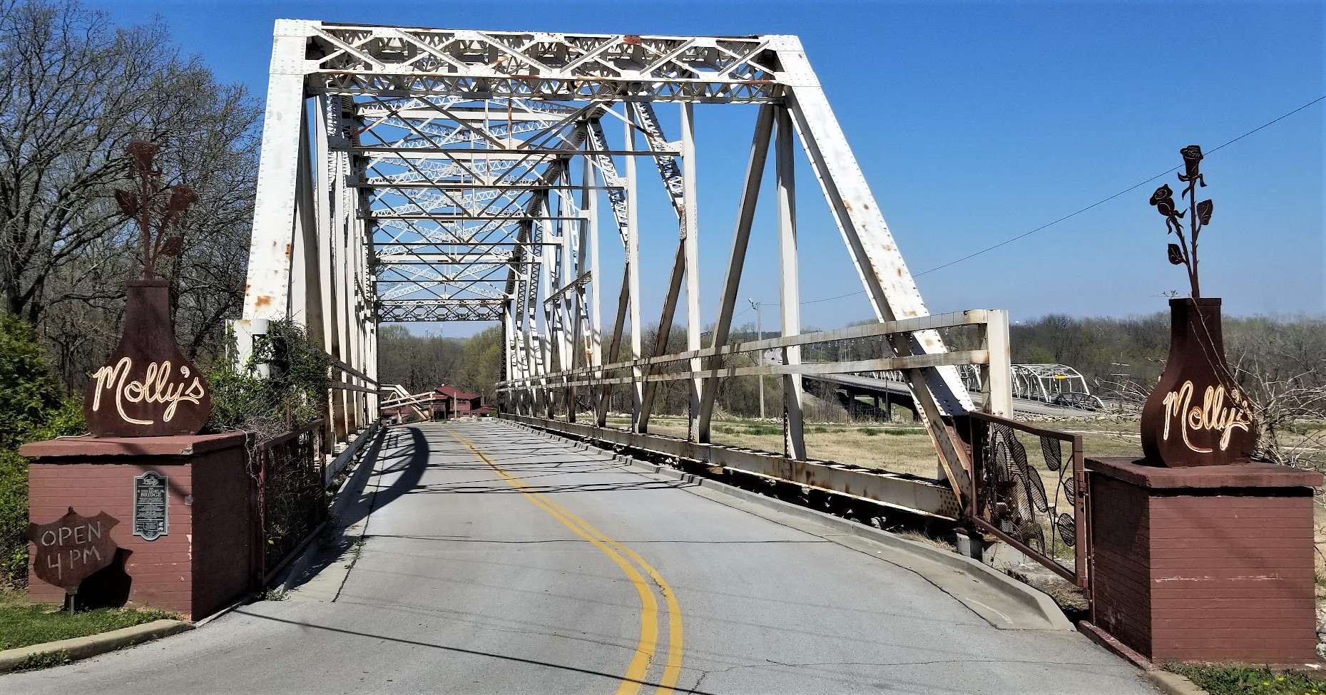
Just a few miles west down Old U.S. Highway 66 into Caddo County, and we get to another one of my favorite historical structures. The Pony Bridge (GC8YAQ7) is the longest bridge on Route 66 at 3,944 feet. A joint venture Oklahoma Federal Aid Project No. 164-H and officially named the William H. Murray Bridge, it spans across the South Canadian River and was completed on July 1, 1933. It was nicknamed the "Pony Bridge" because of its 38 pony style trusses.


Across the county we found the historical Provine Station and our next geocache (GCY1GQ). This old Route 66 gas station was built by Carl Ditmore in 1929. W.O. Waldrop purchased the gas station in 1934 and renamed it the Provine Station. A small tourist court was added for overnight stays. In 1941 Lucille and Carl Hamons became the next owners where they raised their three children in the upstairs living quarters. Lucille operated the business for 59 years.


Continuing westbound into Custer County and past Weatherford, my next geocache stop was for a "Cache Across America - Oklahoma" cache (GCXD60). There's nothing special about the cache or location. However this is a series and there is only one in each state with a bonus in Washington DC. I try to get them whenever I'm in the vicinity. One day when I finally retire, I'll plan a road trip specifically to get the remaining states in the series.

Well it's about that time now when we reached US-183 in Clinton, Oklahoma and leave Route 66 to make that left turn and drive south towards Texas.

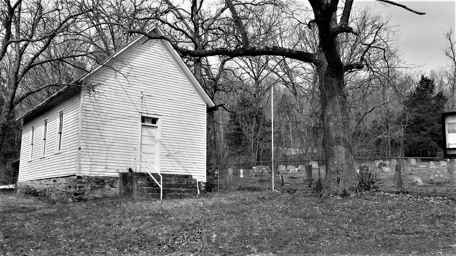
A minute later we cross over into Washita County and soon arrived into the town of Bessie. Our first stop was at the Peace Lutheran Church. The church was organized in 1893. Land was given and a church building / schoolhouse was erected in 1906. This current building was constructed in 1942. The Lutheran Cemetery is next door as well. 


Another historical building in town, and the location of our next geocache (GC15MV7), was the 1916 Bessie Schoolhouse. There's a pretty nice mural on the side of the building depicting scenes of the early days in Bessie. Next door to the schoolhouse was where the bank used to be. Frank Simpson and Fletcher Rickard robbed the bank on January 24, 1928. During the robbery, the cashier of the bank, Ben Kiehn, was killed and Fletcher Rickard was wounded and died later the same day. Simpson escaped and was never caught. The granite cornerstones and granite "Bank" stone are part of the Bessie Memorial Park.


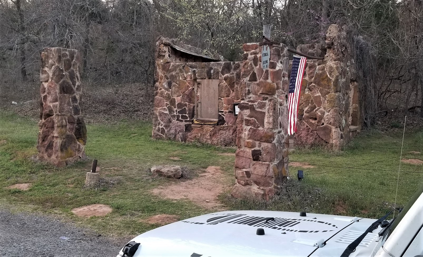
Continuing southbound on US-183, we passed through this small town called Rocky, Oklahoma. Rocky was established in 1898 when two businessmen settled and opened the Rocky Mercantile Store constructed from rock gathered at the Kiowa Reservation. At it's peak in 1930, the population was around 500. Today it is barely over 100. This old church and house caught my attention and I stopped for a quick photo.


Crossing over into Kiowa County, the next town is Hobart, OK. The Rock Island Depot (GCD1E8) was built in 1909 and was used until the 1970's. This was a busy location during the growing years of Hobart. these include World War I and II. The rapidly growing farming industry depended on this rail service to transport it's products. It was left in disrepair until the Kiowa county historical preservation society acquired it in 1987. After many hours of volunteer work and money it was reopened as a museum.


South of Hobart was the small community of Babbs. A picnic area along US-183 is the Babbs Switch Memorial and a virtual geocache (GCD1E9). It was set up to remember those who perished on Christmas Eve in 1924. On this date a Christmas party was going on in a 1-room frame school house when a candle, that was lit on the tree, started a fire. Since the doors to the room opened inward, the kids panicked, pressed against it and could not open it. Everyone inside perished. The school was rebuilt and was used to point the way to safer county schools nationwide. This tragic event is the reason all school doors open outward.

Our next two geocaches were in Tillman County at the Frederick Cemetery (GC7A74B, GC2HNE8). There are over 12,000 internments dating back to 1844. We didn't have time to look around so just finding the geocaches, a photo, and back on the road.


Well we finally made it to the Oklahoma-Texas state line. This means crossing the Red River Bridge (GC8D4F0). Even though highway traffic crosses a newer modern bridge, the old US-70/US-183 bridge is still there. The plaque mentions that it was built in 1939 by the Texas and Oklahoma Highway Departments. The length of its largest span is 75 feet, with a total length of of 5,463.2 feet and a deck width of 24 feet.


One last stop in Texas before reaching home. I wanted to stop by this old abandoned schoolhouse in the ghost town of Gilliland since we were so close. Back a couple of years ago when I was working nearby, I hid a geocache here and it seems to have gone missing. So I replaced it.


I wrote a blog a while back specifically about this town of Gilliland. I tell of the town's history and share a lot of photos of some of the abandoned businesses and houses. You can take a look and read the stories by clicking here.


So that was our 11 Day, 3404 Mile Adventure starting in North Carolina and returning to Texas. Taking the long northerly route of course! Here's a recap with links to each days blog post:

Day #1Turning a 1400 Mile Drive into a 3404 Mile Road Trip! Day 1 in North Carolina and Virginia
Day #2Virginia, DC, Maryland, and Pennsylvania
Day #3: Maryland, West Virginia, Pennsylvania, and Ohio
Day #4: Ohio and Indiana
Day #5Visiting the Birthplace of Ben Hur in Indiana
Day #6Visiting Presidents Lincoln and Reagan in Illinois
Day #7Touring More Abraham Lincoln and Route 66 Sites in Illinois
Day #8Visiting history in St Louis, Missouri via Route 66 and the Gateway Arch
Day #9Exploring the Historic Route 66 Through Missouri
Day #10Cruising Route 66 Through Kansas and Oklahoma

To follow along on our travels and keep up with my latest blogs, you may do so here of course by clicking the "Follow" button to the right. But also by using one or more of your favorite of these social media platforms: FacebookMeWeGabRedditTwitterGETTRInstagram, and TruthSocial. These all link directly to my profiles. Again, please feel free to comment and / or share.

Wednesday, May 24, 2023

2021-04-01: Cruising Route 66 Through Kansas and Oklahoma on Day 10 of Our 3400 Mile Roadtrip Adventure

Today was a very busy day. We continued to follow the historical Route 66 through the corner of Kansas and all the way down to Oklahoma City. There were many roadside attractions to see, many geocaches to find, and some new counties to get, and we tried to visit as many as we could. But we still had to put some miles behind us as our goal is to eventually get down into Texas for the next work project. So join us in the GeoJeep while we share the history and photos from "The Mother Road."


After leaving Joplin with coffee and breakfast, our first geocaching stop was in Kansas... wait no... Oklahoma... or is it Missouri? I guess it depends on where you stand, or park, or... well you get the idea. The virtual geocache (GC6F6D) technically is located in Oklahoma. The stone monument you see was erected in 1938 to mark the spot determined way back in 1857 as the Tri-State intersection. Sadly it had been vandalized, graffitied, and the original plaques stolen. Over the years it had been determined that the monument was off by 50 feet. In 2004, the Missouri Association of County Surveyors rectified the error with a "stand-in-three-states" plaque on the ground marking the correct location. I think this is my third tri-state corner marker that I've been to.


Ok, now that we've got that out of the way... back to Route 66. We stopped for three caches in Cherokee County, Kansas. A quick cemetery geocache (GC497WV) in Galena. A roadside park (GC85F4E) in Riverton highlighting the rather short stretch of Route 66 which passes through Kansas.


Then back over to the original Route 66 alignment and another old historical bridge. Built in 1923 as part of the Jefferson Highway, three years before the US-66 designation, the Rainbow Bridge is a concrete arch bridge and spans 130 feet across Bush Creek. It was added to the National Register of Historic Places in 1983 and is the only one like it within the entire state of Kansas.


And finally a virtual geocache (GCBBF6) at the historical marker for Baxter Springs. Also here in Baxter Springs is this restored old gas station which is now used as the Route 66 Visitors Center. Built in 1930 by The Independent Oil and Gas Company, it was purchased by Phillips 66 Petroleum Company later that year. The original brick house style was modified in the 1940's to an "L" shape adding on a garage for service repairs. The gas station was in use up until the 1970's. After restoration, it was placed on the National Register of Historic Places in 2003.


Route 66 enters Oklahoma into Ottawa County. Passing through the town of Commerce, I saw this little Marathon gas station which was built in 1927. They don't sell gas anymore. But they do sell cookies, candies, and other tasty treats. We resisted the urge to step inside and only left with a photo.


A couple of blocks to the south is the Hole-in-the-Wall gas station. This Conoco Station was built out from a wall of another business in 1929/30. It now serves as a Route 66 Gift Shop.


Following the Mother Road south through Miami, we found this rather unique older section of the original highway. With the early age of automobile travel in the 1900's, Oklahoma began improving the Ozark Trails turning them into an "Auto Trails" system of roadways connecting small rural towns. Working with very tight budgets while trying to still get the distance needed, they paved what came to be known as "Ribbon Road" or "Sidewalk Highway." (GC2ZXEE)

Kinda hard to tell from this photo, but it's basically a one lane paved road that's 9-feet wide with 5-feet wide gravel shoulders. Completed in 1922 as Federal Highway Project No. 8, four years prior to the Route 66 designation. Running from Miami to Afton, this 15.49 miles of narrow road is the only remaining 9-foot section of original pavement on the Old Route 66 system. While it was officially taken out of service in 1937, you can still drive on it today. Just be careful of oncoming traffic!


Passing through Afton, I see these rock walls and stop for a photo. No signs posted and can't find anything online about it. Old gas station? Old store? The ground out front of the sidewalk looks like there may have been gas pumps there. If you know, please leave a comment.


Taking a detour off of Route 66 for a moment, we drove down I-44 to the small Oklahoma town of Big Cabin. Back in my truck driving days passing through here and just as you exit off the interstate at US-69, there's a gigantic Indian Chief statue proudly greeting you as you enter the truck stop. I wanted to stop by here again so that Candy will get an opportunity to see it. Erected on August 9, 2001, the Tall Chief stands at 46 feet and weighs in at 15,500 pounds.


We continued a short drive further south in order to grab another county and a historical virtual geocache (GCFDCD). Just a few miles away in Mayes County is the County Creek Battlefield. Down the backroads through the woods to arrive on a hill with multiple historical markers creating a mental picture of this Civil War battle. On September 18, 1864, a Confederate force of 2,000, mainly General Stand Watie's Indian Brigade, intercepted a Union supply train en-route from Kansas to Fort Gibson. The convoy of 130 wagons worth $1.5 million was captured after a heavy engagement. This was the last Civil War battle in Indian Territory.


Making our way back to continue our drive down Route 66, we arrive in Rogers County. Approaching the town of Chelsea, the historical Pryor Creek Bridge (GC6F24Y) was built in 1926 and carried U.S. Highway 66 traffic from 1926 to 1932, when a new alignment of Route 66 bypassed the bridge.


Once in Chelsea you have to stop for the underground pedestrian bridge (GC6QCMW). Instead of the usual crosswalk from corner to corner, the town built this tunnel to cross Route 66. I guess it was much busier and harder to cross the street back in the day.


A little further down Route 66 and still in Rogers County, we make a stop for the World's Largest Totem Pole as well as a virtual and a traditional geocache (GC9251, GC6M4FJ). Built by Ed Galloway from 1937 to 1948, it stands at 98 feet tall. It was made with 100 tons of sand and rock, 28 tons of cement, and 6 tons of steel. There are 200 carved pictures with four 9 foot indian chiefs at the top.


Our next virtual geocache (GCH7V1) was located in the town of Foyil, just a few more miles down the road. A graduate of Foyil High School, Andrew Hartley Payne (1907-1977) won the 1928 Great Transcontinental Footrace which began in Los Angeles on 3-4-1928 and ended 3,422.3 miles later in New York City 5-26-1928.


Then a short time later we passed this bridge from the 1936 Route 66 alignment. This 24 feet wide bridge replaced the 18 feet wide version from 1925. Now it leads to Molly's Landing Restaurant. I don't think this is the original location of this bridge.


The remains of the Old Route 66 alignment go down the hill to the left from this photo and head down towards the Verdigris River. There's a geocache (GC8H9MC) at the dead end about 1500 feet away from here. There's also an old cemetery up on the hill here. The River Hill Cemetery has about 20 internments dating back to 1882.

Our last geocache for Rogers County was in Catoosa. The Blue Whale (GC4ADE) is a popular Route 66 roadside attraction built by Hugh S. Davis from 1970-72. The Blue Whale is 20 feet tall and 80 feet long and took nearly 3000 hours to build.


Arriving down in Tulsa County, we starting searching for the virtual geocaches in the area. The community of Broken Arrow was named because reeds, found in abundance along streams and riverbeds, were broken to make arrow shafts. The Arkansas Valley Townsite Company chose the site for the town along the proposed MK&T Railroad in September 1902. The first virtual geocache was at Centennial Park (GCEABB) which was dedicated in 2002.

The next virtual geocache was at the Veterans Memorial Park (GCG235). Along with this wall of local veterans, there are two statues dedicated to Major William H. (Hank) Miesner Jr (1939-2003) and Lt. Col. Ernest Childers (1918-2005).


Speaking of memorial parks, we drove a couple of miles away to the Memorial Park Cemetery. It was there we found our next virtual geocache at the gravesite of comedian Sam Kinison (GC48BE). The son of a Pentecostal Preacher, he became a preacher himself at an early age. At age 24, after his first divorce, Kinison gave up preaching and became a comedian. In 1992, he was killed in a car accident when his vehicle was struck by a drunk driver. He was 38 years old.


OK, we don't have time to get to all there is to see in Tulsa. It is already late in the afternoon. So we make our way back to Route 66 and head down into Creek County.

Upon arriving in the town of Sapulpa, our first stop is another virtual geocache at the Sapulpa Trolley and Rail Museum (GCG4JG). The trolley on display here is called the Maggie M., which was built in 1919. The Sapulpa Trolley Company went out of business in 1933. It was donated to the museum in 1997.


The next three geocaches were on the west side heading out of town. There was a letterbox cache at The Heart of Route 66 Auto Museum (GC859VG). Unfortunately, being late in the day, the museum was closed. But the HUGE gas pump outside made for a great roadside attraction and photo ops.


This was followed by the historic Rock Creek Bridge earthcache (GC6Q151). This bridge was built in 1921 to serve the Ozark Trail. It became part of Route 66 in 1926. The bridge was used by motorists traveling "The Mother Road" until a new highway was built to the south of here in 1952.


Then just a few hundred feet down from the bridge was what remains of the Teepee Drive-In Theater (GCG4K2). The drive-in first opened in the 1950's and remained open until the late 90's. At the time of our visit, it was still closed. However, in preparation for writing this blog, I have discovered that the drive-in has been renovated and reopened in the Spring of 2023. And a really cool addition is that along the back row they have several retro RV trailers that can be rented out through Airbnb.


Another geocache in Creek County was at the Magnolia Memorial Gardens Cemetery (GC3AZXC) located just north of Bristow. This cemetery has almost 3,000 internments here dating back to the early 1900's. Most impressive is this 2-story chapel on the grounds.


Our last geocache in Creek County was a roadside attraction called the Route 66 Shoe Tree (GCHPFX). I'm not sure when this started, but it was just a tree along the side of the highway that people tossed their old shoes up and had them hanging from the branches.

Continuing westbound into Lincoln County, our next stop was the Seaba Station in Warwick, Oklahoma. Currently a motorcycle museum, it was originally built in 1924 as a gas station and garage. It stayed in operation serving travelers for many years until 1996. Then the building was restored and the museum opened a few years later in 2000. Unfortunately, the geocache (GC346Y6) was kept indoors and we couldn't sign the logbook after hours.


Now into Oklahoma County. Our next geocache stop (GC4759Y) was located at another historical Route 66 gas station, or what was left of it anyway.  According to the sign: supposedly built in the late teens or early 1920's, before electricity made it out to this rural area. Cold soda pop were only sold on the days when the ice man made it by. Chocolate candy was only sold during the winter when it was cold, otherwise it would melt.


Times were tough back in those days and it was hard to make an honest living. The station owners bought plates to make counterfeit ten dollar bills. A room was added to the back of the station and the only entrance was through a window. After one person was caught passing the fake bills and arrested, their identification gave the address. They were eventually traced back to the gas station. The plates were found, the crime spree terminated, and the owner taken to jail. The old station was closed, never to open again. Many years later and nothing to do with the counterfeiting, a murder victim was found in the abandoned building. The victim was never identified and the mystery never solved.

Our last stop of the day was at Pops 66 (GC162WP), an the iconic destination and must-see landmark on Route 66 in Arcadia, Oklahoma. It features a family-friendly, full-service restaurant, gas station, convenience store, tons of bottled soda, and a 66-foot-tall pop bottle outside that dazzles with multicolor LED lights when the sun sets.


Needless to say after browsing the store for about an hour, we left with a huge assortment of good and "gross" sodas!


That's the end of our LONG day. Twelve hours of driving and sightseeing the roadside attractions along the historic Route 66. Tomorrow we finish up Oklahoma and arrive at our destination in Texas.

To follow along on our travels and keep up with my latest blogs, you may do so here of course by clicking the "Follow" button to the right. But also by using one or more of your favorite of these social media platforms: FacebookMeWeGabRedditTwitterGETTRInstagram, and TruthSocial. These all link directly to my profiles. Again, please feel free to comment and / or share.

Friday, April 7, 2023

2021-03-31: Exploring the Historic Route 66 Through Missouri on Day 9 of Our 3400 Mile Roadtrip Adventure

Winding down on Day 9 of our crazy 3400 mile geocaching and sightseeing roadtrip adventure through history, we spent the day in Missouri trying to follow the original sections of the famous Route 66 highway from St Louis to Joplin. Along the way we stopped at many of the roadside attractions that Route 66 is famous for: a super-sized rocking chair, historic gas stations, old abandoned bridges and more. Oh and let's not forget picking up new geocaching counties along the way too! So hop on board the GeoJeep and let's go for a drive...


Our first two county cache stops was in Crawford County. A travel bug hotel geocache (GCKC79) next to the Crawford County Historical Marker.

Continuing westbound on Old Route 66, we enter the town of Cuba, MO. There we spot several places that look interesting. Among them were the Missouri Hick BBQ with an old garage out building to the side. Or perhaps it was the smoker shack where they slow cooked their BBQ. Don't know but it looked pretty cool.


Next door to it is the Wagon Wheel Motel. Now listed on the National Register of Historic Places, it was built in 1935 and originally called the Wagon Wheel Cabins, Cafe, and Station. Standard Oil leased the station for one year after WWII. The cabin rooms have been upgraded and modernized while still maintaining the exterior historic charm.


A couple of other noteworthy places to stop for a photo in Cuba would be the Holy Cross Catholic Church and the Crawford County Historical Museum, both made of the same stone walls as the motel.

Just a few minutes further in the town of Fanning is our next geocache (GC1G43E). The Rockin' on Route 66 cache brings you to the Fanning US 66 Outpost and the World Famous Rocker seen at the top of this blog post. After a few photos and finding the geocache, we started to drive off.

At the same time I took a drink from my McD's iced coffee I just purchased a few miles back in Cuba. I think I only got 3 or for sips from it as it was more ICE than coffee! So I looped right around and parked back by the Outpost. We went inside to see if they had some bottled Starbucks or Dunkin coffee to pour into my cup. Yep! We ended up spending much more as we walked out with the coffee, a few novelty soda's and some homemade fudge. The proprietor was also very friendly and welcoming. I highly recommend that you be sure to take a look around inside the Outpost as well after getting your required Rocking Chair photo.


While staying on the Old Route 66 can be very interesting, it is also a slower pace and very time consuming. We still have to get to Texas for the next project before too long. Since I already had a geocache found in the next county, Phelps, I jumped back onto the parallel I-44 to quickly put some miles behind us.

Exiting back off into Pulaski County, we make a stop for our next geocache and our first ghost town in a while. "A Gathering of Hookers" geocache (GC174AZ) brings you to the only remnants of the small community that was once called Hooker, MO. Built in 1900, this church building and cemetery are the only evidence of the early pioneers. The slow curving Old Route 66 (1926-43 alignment) passed by right in front of the church. When the new and improved 4-lane US-66 was built (1943-77 alignment), it was straightened and by-passed many of these communities.


A few Route 66 curves later and we arrive at the Devil's Elbow. A small lumberjack settlement began here after the Civil War around 1870. The name derived from a tight U-shaped bend in the Big Piney River. When the lumberjacks would send their logs downstream, they often got jammed up in "a devil of an elbow," which became known as Devil's Elbow.

Also here at the Devil's Elbow are my next three geocaches (GC175JD, GC1TG2P, GC17E9W). I'm just gonna give you a brief description of my two photos below before telling you about a great web page to go look at for more. This bridge was actually built in 1923 as part of the MO-14 state road connecting the communities. Three years later it became part of the original Route 66 alignment. However with the 4-lane realignment of Route 66 in 1943, came a new bridge. This was used only for local traffic and without regular maintenance, it was eventually condemned. Route 66 enthusiasts saved, restored it in 2013, and now open for vehicular traffic once again.


Following the curve around a half-mile to higher ground you get a good look at a section of the Big Piney River where the double truss railroad bridge crosses over.


Now for more historical information and lots of old and new, before and after photos, if you really get into history like I do, take a look at this web page I found on the Devil's Elbow community. It's a quick read and along with the photos and map will give you a better understanding of the Route 66 alignments. As well as some of the businesses that came and gone, and a revealing photo of the 2017 flood.

Making my way further westbound, we arrive in the town of Waynesville, still in Pulaski County, and our next two geocaches. The "Wire Road Stop" virtual geocache (GCE7E0) brings you to an old Stagecoach Stop listed on the National Register of Historic Places. Originally built as a complex with two log cabins in the 1850's, it was later rebuilt with wood in the antebellum style. A stagecoach stop for the Burden and Woodson Stage, also a tavern, used as a hospital during the Civil War, and a hotel after the war. Later abandoned and rundown it had been condemned by the city in 1982. Local citizens got together and saved the historical building. It is now the Old Stagecoach Stop Museum.


The other geocache was at the Talbot House (GC46FPX). One of Waynesville's oldest homes, it was constructed in 1885 by the Rev Albert Washington Davis. Dr. C.A. Talbot purchased the home in 1915 and used it as a residence for his family as well as an office for his medical practice for the next 30 years. After his death in 1945, his widow then rented rooms to boarders. Today, the current owners use it as an Antiques, Collectibles, and Gift Shop business.


Moving on down the road into Laclede County and some more geocaches along the Mother Road. The Gasconade River Bridge (GC8V6TP) is next on the list. I love these old bridges. Like the Devil's Elbow Bridge, this bridge was built during the construction of Missouri's State Highway 14 a few years before Route 66. And again with the new expanded 4-lane Route 66, the lack of maintenance and repairs led to the closure and condemnation by the state in 2014. The Route 66 enthusiasts are trying to rescue and restore this bridge as well.


My next two geocaches are in Lebanon, MO. A quick stop and find for the Graffiti Tunnel (GC8AVN3).


The other geocache has over 500 favorite points and is the second largest cache that I've ever found, with the old Space Coast Geocaching Store cache in Florida being the largest. This one is called Jolly Green Giant (GC1MDCE) and is Missouri's largest ammo can.


There was just one more geocache we stopped for right before leaving the county. Nothing really to see here. But it was a Challenge cache (GC41F8V) that required you to have found a cache in at least 25 states before claiming the find. Well we've found one in 49 states, so I figured I'd stop quickly and sign the log sheet.

Another chance to make up some time as we already have Webster County, I jumped onto I-44 over to Greene County. There were two geocaches (GC2ZFAA, GC2Z72F) near the intersection of I-44 and US-65 that had some favorite points because of their creativity. They were easy to get to and easy to find. Had an interesting containers. What I liked most and wasn't even mentioned on the geocaching listing, was the historical pioneer cemetery just down the short trail.

It was the Union Campground Cemetery which was established in 1840 by the Presbyterian Church for open air camp meetings. Historical research by locals and decedents put the number of burials at around 200. However, documentation has only confirmed 84 burials.


Staying on the Interstate to get through Springfield, I took the first exit into Lawrence County to once again pick up the Old Route 66. Knowing that Route 66 was being built to the west following the old stagecoach trail, Sydney Casey purchased some property in 1925 in the small community of Spencer near Johnson Creek. There he built his businesses in a row of connected buildings, kinda like a mini shopping center. There was a gas station / garage, barber shop, cafe, and grocery store.


Strategically placed on the right just past the Johnson Creek Bridge (GC7TE1D) which was built two years earlier, Casey was open for business from the Route 66 travelers crossing the bridge. Looking west through the bridge, you can just make out his shops on the right past the Jeep. Then another 1/4 mile beyond and further up the hill was the Camp Lookout Cabins for the weary travelers looking for a break from the road.


The businesses prospered until the new Route 66 alignment a couple miles to the north bypassed this section of the original roadway in 1960. Then eventually killed any thru traffic with the construction of Interstate-44. The cabins no longer exist except for a couple of the foundations can be seen in the grass. Fortunately with the historical interest and fans of Route 66, what does remain here in Spencer has been rescued and slowly restored. Along with the geocache on the bridge, there are 4 easy multi-caches going up the hill using clues gathered from the shops (GC7RPV0, GC7RPY7, GC7RPZ0, GC7RQ04).

Passing through west into the community of Phelps, I spotted this old school building. The Phelps School was a one-room school built in 1888. Classes were held there until 1952. It was later abandoned and fell into disrepair in the 1980's. Eventually the community got together and restored it.


Entering into Jasper County and approaching the town of Carthage, we arrive at our next geocache. The Jalopy (GC4QMA6) is another example of artist Lowell Davis creations, an old car driven by a hillbilly and his hound dog.


Well that's our quick tour of Route 66 through Missouri. One day in the future, probably after retirement, we'll get to take a slower and complete roadtrip stopping in all the small communities. But it's late now and we made it to Joplin. Believe it or not we found a great Greek restaurant called Mythos. Time for a bite to eat and then get some sleep! She got the grilled chicken salad and I got the sampler platter.


To follow along on our travels and keep up with my latest blogs, you may do so here of course by clicking the "Follow" button to the right. But also by using one or more of your favorite of these social media platforms: FacebookMeWeGabRedditParlorTwitterGETTRInstagram, and TruthSocial. These all link directly to my profiles. Again, please feel free to comment and / or share.