Showing posts with label silo. Show all posts

Saturday, October 2, 2021

2020-03-30: Roadtrip Day 4: Driving Through Alabama and Arriving in Georgia

Today was the fourth and final day of our Texas to Georgia roadtrip. This has been a great drive so far on the backroads and byways, seeing the sites, geocaching and picking up new counties along the way. For today we found some Civil War history, old cemeteries, a bird-dog champion and more. But I'm getting ahead of myself. Hop on in the GeoJeep and let's get rolling... 


Leaving out of Montgomery, Alabama, our first stop was southeast of town for a geocache at the Carter Hill Cemetery (GC2VFET). With just over 300 interments, the Carter Hill Cemetery dates back to 1844 with the burial of Andrew Allen. Along with his wife and two sons, they are the first four burials in this cemetery.

And then one more quick roadside geocache (GC2R7Y8) before leaving the county.

Continuing eastbound into Bullock County, we arrive in Union Springs and the Bird Dog Field Trial Capital of the World (GC56NF0). On February 21, 1996, the City of Union Springs and the Tourism Council of Bullock county dedicated this life-size bronze statue of an English Pointer. Sculpted by Bob Wehle, the monument pays tribute to the 11 men honored by the Bird Dog Field Trial Hall of Fame, to Bullock County’s unexcelled upland game country and bird dogs, and to the men and women who participate in the sport of field trialing.


Also located in Union Springs was this Log Cabin Museum. From the historical marker: "Early settlers of this area cleared land and built their first homes of logs in the 1830's. This cabin was built by Rueben Rice Kirkland (1829 - 1915) about 1850. He and his first wife had ten children while living in the log home.

"At one time an additional bedroom and chimney were on the right side, and the back porch was closed in for cooking and eating. A small log kitchen stood a few feet from the back and was later converted to a smoke house. The milk house beside the well was on stilts to protect butter and milk from animals.

"In 1981 the Bullock County Historical Society moved the cabin into Union Springs from its original site at Stills Cross Roads in Southern Bullock County and restored it as a museum."


If you look at the very first photo at the top of the blog, you can see that this new location of the cabin is off to the side of the Old City Cemetery, also known as The Confederate Cemetery. The historical marker reads: "Micajah Norfleet Eley donated land in 1849 for the Baptist Church and an adjoining public cemetery. The oldest cemetery in Union Springs, it served the city for 36 years. The Confederate Monument at the center (seen in the top photo) was unveiled at the intersection of Prairie and Hardaway Streets on March 29, 1895 by the Ladies Memorial Association. In 1973 it was moved to its present location.


"Locally known as the Confederate Cemetery, it includes the tombstones of some twenty-two Confederate soldiers. Below the Confederate soldiers' grave sites is a marker which reads: "Union Prisoners of War, 1861-1865, Victims of Plague."


US-82 eastbound over into Barbour County, the next geocache (GC2MY21) was a quick roadside stop at another historical marker. There wasn't anything to see there. Just the historical marker for the Election Riot of 1874 which read: "Near here is Old Spring Hill, the site of one of the polling places for the November 3, 1874 local, state, and national elections. Elias M. Keils, scalawag and judge of the city court of Eufaula, was United States supervisor at the Spring Hill ballot box. William, his 16-year-old son, was with him. After the polls closed, a mob broke into the building, extinguished the lights, destroyed the poll box and began shooting. During the riot, Willie Keils was mortally wounded. The resulting congressional investigation received national attention. This bloody episode marked the end of Republican domination in Barbour County."

Crossing the state line into Quitman County, Georgia, I quickly exit the bridge and turn back towards the reservoir for my next geocache (GC8M6AW). To the right just outside the photo below is the US-82 bridge which crosses over the lake. This little path heading down to the water is what remains of the old road that you used to drive between Alabama and Georgia before the Walter F. George Lock and Dam was built in 1962. Now it sits underwater.


Our last two geocaches were in Randolph County. The first was a quick roadside park and grab just east of the town of Cuthbert (GC7EV1G). The second was in the town of Shellman, Georgia (GC887JW). Originally called Ward Station, Shellman was established in 1883 and named after Major W. F. Shellman, who was the traffic manager for the Central Georgia Railroad. This was the Shellman Railroad Depot.


There's also these muraled silos in Shellman that portray the history and scenes of Shellman's past.


The next county over is Terrell and that's where we'll be staying and working. Time to settle in and relax after a long road trip. I hope you have enjoyed these last four days traveling along the rural backroads and byways of this great country of ours. And if I have inspired you to get off the Interstates and onto the scenic roadways, leave me a comment and let me know.

To follow along on our travels and keep up with my latest blogs, you may do so here of course. But also by using you favorite of these social media platforms: FacebookMeWeGabRedditParlorTwitter, and Instagram. These all link directly to my profile. Again, please feel free to comment and / or share.

Saturday, February 22, 2020

2018-05-05: Meeting Up With Friends From Florida To Go Geocaching and Exploring Waco Texas

Hello friends, adventurers, history lovers, and fellow geocachers! Welcome back to AwayWeGo's (that's us!) Geocaching Adventure Blog. I really appreciate all the likes and comments that we've been receiving on Facebook, Twitter, and here on this blog. Feel free to share our stories with your family and friends. Also, keep leaving your comments, suggestions, as well as a critique every now and then on how I can improve our blog.

OK, on to the fun stuff. I only worked 5 days this week so I arrived home in Killeen last night. That gave us a rare Saturday to go exploring together! WOHOO!! And doubly fun because we have a couple of our Florida geocaching friends staying nearby on their Spring/Summer RV tour. Well in reality, they're camping north of Dallas about 200 miles away. But for Texas that IS nearby! So we decided to meet up with the YankaBucs about halfway in Waco, Texas.


On the way to our rendezvous point, we passed by this old building. Since YankaBucs were a few minutes behind schedule, we decided to stop for a closer look and photos. A faded sign on the back side said "Water Works." Though it confused me about the train caboose coming out the side of the building.


Further research from a 2015 Waco Tribune-Herald Article, this 7,000 square foot brick building was built before 1902 as a pump station for the private Bell Water Company. They punched wells into the adjacent sands for Brazos alluvium groundwater. Acquired by city of Waco in 1904, it continued as a pump station even after the Riverside treatment plant was built in the late 1910s. Contractor F.M. Young acquired the property for his headquarters in the mid-1950s, then leased it to Geoffrey Michaels from 1975 to 1989 as the popular Water Works restaurant. A variety of less successful restaurants and nightclubs followed until disorderly crowds forced closing in 2009.


Continuing down the road a little ways, we met up with YankaBucs at the Waco Mammoth National Monument and our first geocache for the day. It was an Earthcache (GC5ZKCB). Waco Mammoth National Monument sits within 100 acres of wooded parkland along the Bosque River on the outskirts of town. Surrounded by oak, mesquite and cedar trees, the site offers an escape from the modern world and provides a glimpse into the lives and habitat of Columbian mammoths and other Ice Age animals.


On a spring day in 1978, Paul Barron and Eddie Bufkin embarked on a search for arrowheads and fossils near the Bosque River. To their surprise, the men stumbled upon a large bone eroding out of a ravine. Recognizing the unusual nature of the find, they removed the bone and took it to Baylor University's Strecker Museum (predecessor to the Mayborn Museum Complex) for examination. Museum staff identified the find as a femur bone from a Columbian mammoth. This now extinct species lived during the Pleistocene Epoch (more commonly known as the Ice Age) and inhabited North America from southern Canada to as far south as Costa Rica.

Strecker Museum staff quickly organized a team of volunteers and excavation began at the site. Using hand tools such as brushes and bamboo scrapers, crews slowly excavated a lost world. Between 1978 and 1990, the fossil remains of 16 Columbian mammoths were discovered. Their efforts uncovered a nursery herd that appears to have died together in a single natural event. Between 1990 and 1997, six additional mammoths were excavated, including a large male. Crews also uncovered the remains of a Western camel, dwarf antelope, American alligator, giant tortoise, and the tooth of a juvenile saber-toothed cat, which was found next to an unidentified animal.


Getting back into Waco, our next stop was at the Texas Ranger Hall of Fame and Museum. First opening in 1968 on the banks of the Brazos River, a smaller museum preserved the history and heritage of the Texas Rangers. The newer Hall of Fame displays many artifacts, exhibits, artwork and documents relating to this legendary group of law enforcement officers of Texas and the old west. There was even a whole room dedicated to the "Lone Ranger" fictional character full of TV and movie memorabilia, which Mr YankaBucs really appreciated.


Next to the museum is the historic First Street Cemetery dating back to Waco's founding in the 1850's. First Street Cemetery is the oldest public cemetery in Waco and is composed of three distinct cemeteries: City Cemetery, Odd Fellows Cemetery and Masonic Cemetery. In 1852, City Cemetery and Masonic Cemetery were officially established. It is not known when Odd Fellows Cemetery was officially established, but it was acquired by the City of Waco in 1866.

Now it really gets interesting when you combine the cemetery, the museum, and the Fort Fisher Park in the same area. It was discovered during the Hall of Fame expansion during the 2007-2010, that there were human remains underneath. It turns out that during the creation of the Fort Fisher Park and first Ranger museum in the late 1960's, as well as a "relocation" of graves to the larger Oakwood Cemetery to the south years earlier, that ONLY headstones were moved and not the remains of the bodies buried underneath. As you can imagine, that caused a LOT of community outrage and delays during the renovation and expansion plans!

As a surveyor myself, I had to include a photo of the Major George B Wrath statue there. Perhaps they could have used him to relocate the cemetery.


Now it is time for lunch. We saw this place across the highway also on the river called Buzzard Billy's. The decor and location were great and the food was excellent! However, I forgot to take any pictures. After filling up with a delicious lunch, we decided it was time for a walk along the river front to burn off some calories.

We crossed the Waco Suspension Bridge first. This was the Brazos River Crossing of the Chisholm Trail and a virtual geocache (GC2B5A). Imagine all the history that once crossed over this bridge.


In 1866 the Waco Bridge Company was granted a 25 year charter to build a toll bridge here. The charter guaranteed that no other bridge or ferry could be built within five miles. Construction began in 1868 and, after much financial difficulty, was finished in 1870. Bridge traffic included wagons, pedestrians, and cattle herds. Special rates were given to heavy users. From 1875 to 1889 the public agitated for a free bridge, but the company retained its monopoly. Then, in 1889, the bridge was sold to McLennan County which gave it to the city of Waco as a free bridge.


We continued strolling along the riverwalk finding various geocaches along the way and enjoying the day. (GC7ETPC, GC7ETQF, GC7ETQ9, GC7ETPY, GC6D2E, GC7C2NN, GC7C2N7) One of them had this monument. The inscription read: "Shakespeare! Daign to lend thy face, This romantic nook to grace, Where untaught Nature sports alone, Since thou and Nature are but one…1616-1916."


An easily overlooked memorial that pays tribute to William Shakespeare (1564-1616). How and why is it there? In 1916, on the 300th anniversary of his death, the Waco Shakespeare Club had it constructed and designed by Paul G. Silber, Sr. According to the Waco Shakespeare Club record’s at The Texas Collection, Baylor University, the organization began in the late 1890's at the Waco home of Kate Harrison Friend and her mother, Arimenta Harrison Friend, “conducting a private school guaranteeing their pupils thoroughness for higher grades.” Here, Kate Friend “…organized a class in the study of Shakespeare for the single young ladies of the elite of Waco. Here so much profit and enjoyment was experienced, that on request, a class for young matrons was formed.” Thus officially forming the club in 1899.


After making it around the riverwalk, we drove a few blocks over to the Dr Pepper Museum (GC2ATKV). Dr Pepper is a “native Texan,” originating at Morrison’s Old Corner Drug Store. It is the oldest of the major brand soft drinks in America. Like its flavor, the origin of Dr Pepper is out-of-the-ordinary. Charles Alderton, a young pharmacist working at Morrison’s store, is believed to be the inventor of the now famous drink. Alderton spent most of his time mixing up medicine for the people of Waco, but in his spare time he liked to serve carbonated drinks at the soda fountain. He liked the way the drug store smelled, with all of the fruit syrup flavor smells mixing together in the air. He decided to create a drink that tasted like that smell. He kept a journal, and after numerous experiments he finally hit upon a mixture of fruit syrups that he liked.


Dr Pepper gained such widespread consumer favor that other soda fountain operators in Waco began buying the syrup from Morrison and serving it. This soon presented a problem for Alderton and Morrison. They could no longer produce enough at their fountain to supply the demand. Robert S. Lazenby, a young beverage chemist, had also tasted the new drink and he, too, was impressed. Alderton, the inventor, was primarily interested in pharmacy work and had no designs on the drink. He suggested that Morrison and Lazenby develop it further. Morrison and Lazenby were impressed with the growth of Dr Pepper. In 1891, they formed a new firm, the Artesian Mfg. & Bottling Company, which later became Dr Pepper Company. Lazenby and his son-in-law, J.B. O’Hara moved the company from Waco to Dallas in 1923.


Around the corner from there was the Magnolia Market. Magnolia Market at the Silos, commonly called Magnolia Market, is a shopping complex that encompasses two city blocks in downtown Waco, Texas. It is marked by two 120’ high silos, built in 1950 as part of the Brazos Valley Cotton Oil Company. The grounds opened to the public in October, 2015.

The complex is owned by Chip and Joanna Gaines, TV personalities best known for HGTV's Fixer Upper TV series. The Silos, Waco, TX The grounds include a 12,000 sq. ft. retail store located in the historic grain barn and office building, a food truck park with picnic tables, a garden store, bakery, and lawn area. There was some kinda 5K event in the area today, so the place was just packed! This is the line below just for the bakery!


While the YankaBucs took a peak inside the Market, Candy and I stayed outside in the courtyard / lawn area because it was so crowded.

As we walked around the corner on our way to dinner, we passed by the First Baptist Church which I thought was worthy of a photo.


Then we arrived at Hecho En Waco Mexican Restaurant for another good meal. After an exhausting nut rewarding day, it was time to say our good-byes to our good friends the YankaBucs and head home. I hope you have enjoyed our tour of Waco, Texas. Until next time...

Thursday, March 3, 2016

2016-02-28: Geocaching Through History and Counties in North Texas

Hello again and welcome back to our Geocaching adventure blog. We hope you have been enjoying our travels so far. Today we set out to find caches in some new Texas counties. We're past the halfway point finishing the day with 133 of the 254 Texas counties.

Setting out from Lubbock after breakfast, we headed north on I-27. Our first stop was the Abernathy Cemetery in Hale County. A quick cache find here. The cache was located in some trees behind this headstone. Of all the cemeteries we've been in and the headstones looked at, I think this was the first with a Corvette on top. I'm sure this one cost a pretty penny too. However, after spending so much on this headstone, you would have thought they would have spelled "BELEIVE" correctly!


Continuing north on I-27 and a few more quick caches near an old grain silo, another at the Hale Center Cemetery, and follow by the Kress Cemetery.


Then, a couple miles to the northeast of the town of Kress and sitting out in the middle of farm land lies three very lonely graves. The Wright Cemetery cache page (GC5R9B1) doesn't give much history, but I was able to locate some info at Find A Grave showing 11 burials here. I only found 3 headstones. Looks like headstones have been run over by farm tractors throughout the years.


About a mile down the road from the cemetery looking across the farms and the flat plains, I saw a tiny black silhouette of an old truck and just had to investigate. And this is what we found sitting out on the corner of the dirt road and the end of the driveway to the farm house. It had seen better days and would make a great restoration project.


The next cache on our journey today was at Rose Hill Cemetery (GC31F7A). The history of this community cemetery dates back to October 1890. Just three months after Swisher County was organized and Tulia was named county seat. The first recorded burial here is that of 18 year old Louis Harral who died on October 17, 1890. His parents obtained permission from landowner T. W. Adams to bury their son on this hillside south of the Middle Tule Creek. Twelve days later, 4 year old Robert Alonzo Hutchinson died and was buried on the hill near Louis. In 1906 five acres of land surrounding the graves were officially set aside for a community cemetery.


Also in Tulia on display at the local VFW is our next cache (GC14K6N). This retired North American F-86 SabreJet.


Our next stop located in Briscoe County was built in 1894 of handcut stone hauled here by horse-drawn wagons from Tule Canyon. The Briscoe County Jail (GC2KVTG) stands as the lasting reminder of what courage and dedication mean in preserving law, order and integrity.

Early day sheriff's families rented the lower floor as a residence. It was also used by Red Cross workers for sewing during World War I. Near the old jail is the county courthouse and administration building.


Continuing east from Tulia over to the town of Silverton for our next cemetery cache (GC5N53J). I couldn't find much history about Silverton Cemetery, but while finding the cache I spotted these to headstones belonging to Robert S. Christian (23) and Warner S. Reid (24). They both died on the same day of October 23, 1895. After doing further research, I found newspaper article from from 1995 that had the story of these two. In summary, while moving a very large herd of cattle along with 75 other cowboys; lightning struck killing these two young men, both their horses, and ten cattle. You can see the full story from the newspaper link.


A couple more caches later and we're in the little town of Quitaque and our next  two caches (GC1RVHP). The first settler in the area was the Comanchero trader José Piedad Tafoya, who operated a trading post on the site from 1865 to 1867, trading dry goods and ammunition to the Comanches for rustled livestock. In 1877 George Baker drove a herd of about 2,000 cattle to the Quitaque area, where he headquartered the Lazy F Ranch. Charles Goodnight bought the Lazy F in 1880 and introduced the name Quitaque, which he believed was the Indian word for "end of the trail."

Residents used other area graveyards to bury the deceased until 1922 when brothers Alvin and Edgar Howard donated ten acres for cemetery use. The first person interred in RestHaven Cemetery (GC1QZJV) was Katie Daniel in 1922.

The next town down the road was originally called Turkey Creek, then Turkey Roost by the locals. Eventually it was shortened to just Turkey by the time the Turkey Hotel, now a Bed & Breakfast, opened its doors in 1927. There was supposed to be a cache hidden near the hotel (GC1X8B3), but  we couldn't find it and neither could the last few cachers. It looked as though there may have been some bushes there at one time. And the cache owner hasn't been active since 2010.


Turkey is also known for being the hometown of Bob Wills which is our next virtual cache (GCCDBD). James Robert "Bob" Wills (1905 – 1975) was an American Western swing musician, songwriter, and bandleader. Considered by music authorities as the co-founder of Western swing, he was universally known as the King of Western Swing. Wills formed several bands and played radio stations around the South and West until he formed the Texas Playboys in 1934 with Wills on fiddle, Tommy Duncan on piano and vocals, rhythm guitarist June Whalin, tenor banjoist Johnnie Lee Wills, and Kermit Whalin, who played steel guitar and bass. The band played regularly on a Tulsa, Oklahoma radio station and added Leon McAuliffe on steel guitar, pianist Al Stricklin, drummer Smokey Dacus, and a horn section that expanded the band's sound. Wills favored jazz-like arrangements and the band found national popularity into the 1940s with such hits as "Steel Guitar Rag", "New San Antonio Rose", "Smoke On The Water", "Stars And Stripes On Iwo Jima", and "New Spanish Two Step".

Also in town is this old restored gas station and Bob Wills and the Playboys tour bus.


Moving on to our next county and next cache (GC62PGC). This area of Motley County was first called "White Flat" due to the tall white needlegrass which covered the flat prairie land. A post office, named Whiteflat, was established for the rural settlement in 1890 at the request of W. R. Tilson.

At its height, the community boasted four grocery stores, three service stations, three garages, two cafes, a hardware store, two gins, and three churches. A school first housed in a one room schoolhouse built by volunteers, opened in 1890. It was replaced by a four room school in 1908, and in 1922 a new two story brick structure was erected (see photo). It also served as a community gathering place.

Dependent on an economy based on agriculture and small family farms, the community began to decline during the depression and dust bowl years of the 1930's. The Whiteflat school closed in 1946 when it was consolidated with Matador schools. The local churches disbanded in the 1960's, the post office closed in 1966 following the death of the last postmaster, and the last remaining retail store closed in 1968. A few residence still exist, but it's pretty much a ghost town.

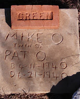
The Whiteflat Cemetery (GC2P34E) dates back to 1894. The hardest thing to see although quite common at that time, are headstones for babies and children. And here the Green family had three. And based on the headstones, they were probably of little means as well.


Our next cache in Motley County was Bob's Oil Well (GC17NTQ) and a piece of American roadside attractions. From the historical marker: "Greenville, Texas native Luther Bedford "Bob" Robertson (1894-1947), a veteran of WWI, came to Matador in the 1920's. He was a gas station attendant in 1932 when he decided to open a service station here. To promote his new business, he built a wooden oil derrick over the station. He patented his design, and in 1939 replaced the wooden derrick with one of steel that reached 84 feet in height and included lights.
Robertson was a gifted businessman and promoter, and he used any opportunity to advertise his operation and attract customers. He kept a cage of live rattlesnakes for the amusement of tourists, and from that initial attraction grew a zoo that included lions, monkeys, coyotes, a white buffalo and other animals. He paid long distance truckers to place advertising signs at strategic points across the nation noting the mileage to Bob's Oil Well in Matador, and they became well known to the motoring public. As a result of his success, Robertson enlarged his operation to include a grocery, cafe and garage.
Bob Robertson dies in 1947, and two weeks later a high wind toppled the steel derrick that had been the trademark of his business. His widow restored it two years later with even larger lights. The business did not continue long after, however, and closed in the 1950's. Later efforts to re-open it were short lived. Today, the site serves as a reminder of a time when such bold roadside architecture was in its infancy and of a man who, through his business, widely promoted his adopted hometown."


The Motley County Jail was next. Similar to the Briscoe County Jail above, this 2-story jail was erected in 1891, the year Motley County was organized. Cells were on the top floor of the structure and the jailer's living quarters on the lower level. The first courthouse, also built in 1891, later burned, but this jail remains as a symbol of Motley County's frontier heritage.


Our last cache to highlight was at the Cottle County Heritage Museum (GC13AA8). I liked the old ambulance and fire truck outside. 


It was a long day and I think we drove over 300 miles. But we learned a lot of history, saw some cool sites, and just had a great day driving through Texas.