After our long 5300 mile road trip to purchase our new-to-us 2000 American Eagle motorhome, we arrived in Bonham, Texas for my next work project. The solar farm was already completed and we were just there for a few weeks for the reclaim work. That consists of removing the gravel from the laydown yard and using it to touch up the roads. Then spreading the topsoil back out so the grass regrows.
But while here, we got a chance to explore the history of Bonham and grab some geocaches around town. I also discovered several Pioneer children's graves from the 1800's hidden among some trees that was not listed in the Find-A-Grave database. So come with us as we explore Bonham, Texas...

One of Texas's oldest cities, Bonham dates to 1837, when Bailey Inglish built a two-story blockhouse named Fort Inglish about 2 miles from the current downtown. Inglish and other acquaintances settled there in the summer of 1837, and the settlement was named "Bois D'Arc". The Congress of the Republic of Texas named the city Bloomington in 1843, but renamed it Bonham in honor of James Butler Bonham, a defender of the Alamo. On February 2, 1848, Bonham was incorporated as a city. A 1936 statue of Bonham by Texas sculptor Allie Tennant is on the courthouse grounds.

Some of the early pioneers of Bonham are buried in the Bailey Inglish Cemetery (GC83VFM). Obviously, Bailey Inglish (1798-1867) and his wife Nancy (1806-1878) are interned there. The family marker is seen at the top photo of this blog.

Another is Dr. Daniel Rowlett (1786-1848). He came to Texas from Virginia in 1836. He served as a Congressman in the Republic of Texas from 1837-40 and again in 1843-44. His initiative pushed for the creation of Fannin County in 1837.
After his wife died, Col. James Tarleton (1789-1861) organized a force of 36 riflemen in his home state of Kentucky and headed to Texas in 1835 to join in the fight for Texas Independence. Tarleton fought in the victory at San Jacinto in 1836. He settled in Fannin County with his son Robert Price Tarleton (1833-1897).

The Texas and Pacific Railroad was built Eastward to Bonham in 1873. A small wooden depot erected that year was replaced by this larger brick structure in 1900. It continued operations until 1950.


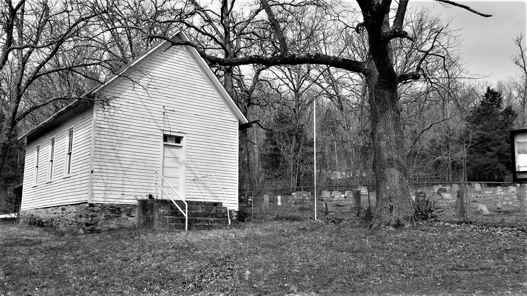
As I mentioned in the opening of this blog, I discovered some pioneer family graves hidden among some trees. About ten miles south of Bonham is the solar farm that I was working on. Tucked inside this group of trees separating two sections of solar panels were five headstones belonging to children of James & Wincy Miller, early settlers to the area.

One of the headstones is pictured below. No name. Just infant son of and the dates. He lived for eleven days in June 1871. Another headstone can be read also. It had Ota Aurora Miller but no dates. It just said Aged 2 weeks. Only a few letters can be made on the third stone but not enough to understand. The last two are so worn smooth they have no distinguishing markings.

This is the area within the group of trees where the graves are located. Hopefully one day information can be discovered on the remaining few headstones that can't be read.

Back to the parents James (1830-1895) and Wincy (1838-1899), they are both buried in the Moores Chapel Cemetery located within the town of Bonham. Their other four children that survived childhood and went on to live a normal life were Tennessee (1863-1934) of Houston, Lenora (1872-1963) of Texarkana, George (1874-1966) of Texarkana, and David (1879-1931) of Corpus Christi.
So that's just a glimpse of Bonham, Texas. There is plenty more here to see and a few things like this hidden pioneer family cemetery which you won't have access to.
In our upcoming blogs is another road trip. We will be three weeks exploring Colorado, Wyoming, and Montana. I hope to see you back again soon.
To follow along on our travels and keep up with my latest blogs, you may do so here of course by clicking the "Follow" button to the right. And there's also my main website at AwayWeGo.US for the complete index of my traveling adventures going back to 2005. But also by using one or more of your favorite of these social media platforms: Facebook, MeWe, Gab, Reddit, Twitter, GETTR, Instagram, and TruthSocial. These all link directly to my profiles. Again, please feel free to comment and / or share.


.jpg)