Showing posts with label creative. Show all posts

Saturday, February 5, 2022

2020-09-19: Geocaching Roadtrip Through Georgia Finding Abandoned Buildings, Old School, and Santa Claus

Hello Everyone. Well we had a 4-day weekend off from work so I decided a spontaneous quick trip down to Florida and back would be good to fill the time. We packed a weekend bag and left the Lake Norman RV Resort in North Carolina on Thursday morning, arriving at a hotel on Daytona Beach. Friday was spent visiting family. Todays' blog is about our Saturday drive north through Georgia, sightseeing and geocaching along the way. So climb onboard the GeoJeep once again and let us see what we can find...


Driving north on I-95 and arriving in Brunswick, Georgia, I exit onto US-25 / US-341 to take the backroads and byways so that we can enjoy the ride more than the Interstates. It didn't take very long to find a treasure and reaffirm the reason we prefer the backroads of rural America. Passing through the small community of Gardi, Georgia, I spotted this old red brick building and just had to turn around for a closer look.


The Gardi area was being settled by the Street Family during the colonial days of Georgia. Around 1900 and as the community was growing, this brick building was constructed by the Odom Family and first used as a post office and general store. The Fore Family purchased the building around 1940 and turned it into an apiaries, selling their "Fancy Honey" to the community. The family still owns the property but has since expanded and moved their business to Darien, Georgia. The abandoned building is a reminder of Gardi's historic past.

Since I was already here, I checked the geocaching app and lo and behold there's a geocache placed here too (GC377Y1). Also on the corner is a Geodetic Survey Bench Mark which was placed way back in 1917.


Moving along up the highway at the snails pace of 55 MPH, on a 4-lane highway, with nothing but trees all around on both sides, makes me miss Texas. This same stretch of highway would easily be 70-75 MPH in the Lone Star State!


Turning north on US-1, I arrive into my first needed geocaching county. We stopped in a small town called Santa Claus, Georgia, yes there really is a town called Santa Claus, to find a quick geocache for Toombs County.


Next up over in Treutlen County, we get to our next geocache at the Old Soperton School (GC5DVA8). I spent about an hour or so researching this old schoolhouse. However I couldn't find any history on it. Maybe one of you readers can share some insight to this place.


We also stopped by a cemetery about 8 miles north of Soperton for another geocache (GC49JYF). The small well kept Ricks Family Cemetery has 72 interments according to the FindAGrave website. Daniel Ricks (1795-1878) settled in this area and opened the Blackville Mill. His son, 28 year old John Ricks, was the first to be buried in this cemetery in 1859.


Moving along into Johnson County, I stopped for a quick roadside guardrail geocache (GC2ADG3) just outside the town of Wrightsville.

A few miles north of there in Washington County, I arrived at my next geocache (GC5QVK3) with a sad story of forgotten history. According to the CO of the now archived geocache: "My dad bought this land in 1959. He passed away in 1996. My sister and I now each own part of this land. When my dad acquired the property there were remnants of markers or head stones made from coarse materials, probably a concrete-like material. A previous owner had removed the markers from the small graveyard. He plowed and planted over the area. No one knew the actual location of the graves. The story has been passed down that it was a small area of graves .No bones or materials have ever been found. As the older generation has passed on, the younger people here do not know that this ever existed. While there is no way to ever know more about this, we can still remember them." Only thing there now is this cross next to a pine tree.


Still in Washington County just a mile or two away, was this really creative geocache container (GC5QN7X) at the corner near the entrance of the owners ranch.


Further north just past the town of Gibson, We stopped for one more quick roadside guardrail geocache for Glascock County (GC3DA5F).

Now it's early evening and time for us to grab some dinner and find a hotel. We made it about halfway back to the RV Park in NC. See you back tomorrow to finish the roadtrip.

To follow along on our travels and keep up with my latest blogs, you may do so here of course. But also by using you favorite of these social media platforms: FacebookMeWeGabRedditParlorTwitterRVillageGETTR and Instagram. These all link directly to my profile. Again, please feel free to comment and / or share.

Saturday, October 30, 2021

2020-05-10: Jeeping and Geocaching in a Florida Forest Finding some Creative Caches!

WOW, it was a fun day! Welcome back to my AwayWeGo's Geocaching Adventures Blog. Normally my adventures are roadtrips finding geocaches that focus more on the destination. Today was all about finding some creative geocache containers in the Osceola National Forest. So come on aboard the GeoJeep and let's see what kind of crazy caches we can find...


After talking to some of our local geocacher friends, we heard about a fun power trail (a lot of caches along a road at or near the minimum required distance apart) where the majority of the geocache containers were unique and amusing. These were located within the Osceola National Forest in North Florida, not far from the campground which we were staying in Fort White.


After a few hours of wheeling and tromping through the woods, we had found a total of 41 geocaches with only 1 DNF. Unlike the other of my blog posts, I give you the caches GC# and link to the geocache page. However for this blog, because I'm showing you photos of the geocache itself, I'm not going to provide that info so that you might be pleasantly surprised when you find it yourself. Your only hint as to the location is that they are just a few of the nearly 1000 geocaches hidden within the Osceola National Forest.

I leave you now with photos of these creative geocache containers. If these are sparked your interest in this hobby, feel free to ask a question or leave your comments below. I always look forward to hearing from my readers.

See you next week...


To follow along on our travels and keep up with my latest blogs, you may do so here of course. But also by using you favorite of these social media platforms: FacebookMeWeGabRedditParlorTwitter, and Instagram. These all link directly to my profile. Again, please feel free to comment and / or share.

Saturday, February 6, 2021

2019-05-05: Moving Day Roadtrip from Texas to North Carolina Day 3 in SC and NC

Good morning friends. If you're just now dropping in on this roadtrip, you may want to catch up first on Day #1 and Day #2. Starting out this morning in South Carolina on day #3 of this roadtrip from Texas to North Carolina. I start a new solar farm project tomorrow, so gotta get there today and get settled. Then gonna find the jobsite so I know where I'm going and get some groceries for the week. But I'm getting ahead of myself. Let's get driving... 

Checking out of the hotel in Lugoff, SC, I grabbed the geocache (GC22BH6) down the block for a Kershaw County find. Then drove up the Interstate and crossed the border into North Carolina.


Continuing up the highway and continuing to pick up new counties, I stopped for a quick geocache (GC3AFP2) in the town of Wade, NC for a find in Cumberland County. From there I drove over to Spivey's Corner, NC for a virtual geocache called "Holler if you Hear Me" (GCAD33) and a find in Sampson County. Spivey's Corner is known as the "Hollerin' Capital of the World" since 1969. Though on this day it was fairly quite.

On the way to my next geocache I reached a milestone. At just one week shy of being a year old, my GeoJeep hits 60,000 miles! That's a lot of roadtrips!


Stopping in Wilson County for my next geocache (GC6H2T8), not too far away was this old abandoned church. The Corner Line Primitive Baptist Church was a predominately black church built around 1900. The first pastor was Sam Brystern who led the congregation until he passed in 1930. Wiley Barnes took over the role until handing it over to his son Tom Barnes in 1964. I'm not sure when it was last used, but I saw a photo from 2012 that showed it abandoned. You can find out more on this church and the area's early history afamwilsonnc website.


The geocache container attached to a butterfly in the woods.


I arrived in Washington, NC and checked into a hotel. Then I drove up to Pinetown and saw where the jobsite was and how long it took to drive there. I checked for geocaches in the area and there was one right around the corner (GC35QJN). That gave me a find for Beaufort County. Back at the hotel, there was another geocache so I grabbed that one too (GC3N3YA).

So that's it for my three day roadtrip from Texas. I was glad to have you riding along. I'm scheduled to be here at this project for 2-3 months. North Carolina has 100 counties and I have only found geocaches in 30 of them. So be sure to check back in frequently as I drive from county to county finding geocaches and exploring North Carolina. See you again soon.

Saturday, January 23, 2021

2019-05-03: Moving Day Roadtrip from Texas to North Carolina Day 1 in TX, LA, & MS Cemeteries, Historical Sites and an Old Church

Well it's that time again. I finished up on the wind farm down in South Texas and have to be in North Carolina on Monday to start a solar project. So another roadtrip is ahead of me. Supposed to be 2-3 months there in NC. Unfortunately the wife will still be here in Texas working. But hopefully the time will pass quickly and the next project will be back in Texas. But for now, lets hit the road and see what kinda cool places we can find.


My first stop, after Duncan Donuts for iced coffee and a bagel of course, was just outside of Waco, Texas. "Sleepy Hollow" (GC3D0BB) was a cemetery and the location of a geocache. Unlike the typical cemeteries I visit, this one is a pet cemetery! I think I've only encountered maybe one or two pet cemeteries before. This one had a doghouse and a fire hydrant as headstones. One thing I didn't see were any zombie cats or dogs that have been resurrected!


Also a little further east outside of Waco was the "Shootout at the Double EE" (GCGM3X) Ranch Road is a virtual geocache. On April 19, 1993, the FBI and ATF raided the compound of the Branch Davidian Church. After 100 canisters of tear gas being deployed over a 6 hour period, a fire broke out and the compound was engulfed in flames. David Koresh and 75 of his followers, including 25 children, perished in the blaze. Only nine managed to escape. The church has since been rebuilt.


My next two geocaches are in Corsicana, Texas at the Oakwood Cemetery (GC3EXG7, GC4G8EJ). There are nearly 14,000 burials dating back to 1833. There are several historical markers throughout the cemetery as well. One of the caches highlights a native of Huntsville, Texas, Samuel R. Frost grew up in Navarro County and in 1863 enlisted in the Confederate army. After the Civil War, he studied law and was admitted to the bar in 1870. In the years that followed, Frost served as Navarro County attorney, county judge, district judge, and state legislator. He and his wife, Mary (Winkler), were the parents of nine children. The town of Frost (20 mi. W) was named in his honor.

Another interment, and a more recent one, is Aaron Dale Allston (1960-2014). He is the author of 13 Star Wars novels as well as many other science fiction, game based fiction and mystery novels, short stories and technical guides for writers.

But the one historical marker that caught my attention was by the grave of David Reed Mitchell. Like myself, he was also a surveyor. From the historical marker: "Born in 1797 in North Carolina, arrived in Robertson County, Texas in 1845. He was a surveyor by trade, and had surveyed the upper Trinity and Brazos river areas in 1844. He became surveyor of the Robertson County land district, as well as the original land of Navarro County and Corsicana.

Mitchell was also a land speculator of sorts, and by 1847 he owned a large amount of land in Navarro County. With two partners, Thomas I. Smith and James C. Neill, he donated one hundred acres on which the town of Corsicana was founded. For a time he operated an inn in the town, sometimes referred to as the "lower hotel" because of its location in proximity to another hotel run by pioneer Hampton McKinney.

David Reed Mitchell married Mary Ann Higgins, and they were the parents of five children. Mitchell continued to live in Corsicana until his death on Oct. 7, 1853. He was buried in Oakwood Cemetery, and the citizens of Corsicana erected a monument at his grave in 1899. Of the three partners who donated land for the city of Corsicana, Mitchell is the only one buried here."


Before leaving Corsicana, I had to stop and get one more geocache here. "The Fruitcake Factory" (GCF11B) is located at the Collin Street Bakery. Yes, that dreaded fruitcake that usually makes an appearance around the Christmas holidays. The Collin Street Bakery is the largest producer of fruitcake in the world. They have been baking since 1896 and are shipping to almost 200 countries around the globe.


Another goal of this roadtrip is to pickup new geocaching counties. I've already completed my Texas counties. Now that I've crossed over into Louisiana it's time to pick off a few more of those. Bienville Parish was the first one with a quick roadside park and grab geocache (GC5BQVX).

My next geocache and county was in Quachta Parish in the town of Calhoun. "Breaker 19" (GC1V79Q) was a creative cache at a CB shop. I posted a photo below and also my first attempt at bringing you a video. Hopefully it works.


Just up the street in Calhoun was the Mount Zion Cemetery. There wasn't a geocache there, but it's still hard to pass up an old cemetery. There are over 500 interments that date all the way back to 1852 belonging to an eight year old boy named Robert Simmons Gaston who died in 1852 while visiting this country with his mother.


Located in Richland Parish, Holly Ridge was established in the early 1900's as a sawmill town in the middle of a large farming area. The company started with making barrel heads and later changed to the lumber industry. The company that owned all the timber land was Chess and Wymond out of New York state. Mr. Franklin leased all the land and cut all the timber. After the timber was gone it became a large farming area owned by the Franklin family. A quick roadside geocache (GC29MH5) in Holly Ridge off of I-20 to claim that county. Some dark clouds overhead isn't very promising though. I did get some heavy rain along the Louisiana / Mississippi state line.


After the rain and crossing over into the state of Mississippi, I jump off of I-20 and drive up into Madison County and the town of Annandale. There I find my next virtual geocache at the Chapel of the Cross (GC29MH5). After John and Margaret Johnstone arrived in Mississippi from North Carolina in 1840, they lost two of their sons that same year and buried them on their land, which would become the Annandale Plantation. John had the idea to build the chapel but died in 1848 before he accomplished it. The Gothic Revival chapel was erected in the 1850's by his wife Margaret L. Johnstone as a memorial to her husband.


Behind the chapel is the cemetery which now contain over 250 interments, the oldest being the two sons from 1840. The geocache page mentions one grave in particular as a question from which you need to answer in order to claim credit for the virtual geocache. But it doesn't give you the history of the grave. Henry Grey Vick was killed in a duel at age 23, just days before he was to marry Helen Johnstone, the daughter of John and Margaret. Helen was said to have worn her wedding dress to Henry's funeral. And legend has it that the "Bride of Annandale" continued to love Henry the rest of her life, even after marrying George Harris, and that her ghost is often seen sitting on a bench near Henry's grave.


Now that the sun is down and it's dark out, my plan is to keep going as long as I can find the geocaches. If I can't find a cache and need the county, then it's time to find a hotel and wait for daylight.

But next up is another virtual cache in Canton, MS. "Casey's Intended Destination" (GCF5FE) was located at the old train depot, now a museum. Canton was the destination of the famous train engineer John Luther "Casey" Jones when his train derailed after colliding with a stalled freight train 15 miles up track. He was traveling at about 75 MPH when he noticed the broken down train cars still on the track about 300 feet ahead near a side track switch.

While he could have jumped off the engine to save his live, as did the fireman on board, he stayed with the engine pulling on the brake and reversing throttle to protect those on the ground and passengers of the other train. He managed to slow down to approximately 35 MPH before colliding with the caboose and 3 of the freight cars when his train derailed. He died upon impact and time was recorded at 3:52 AM by his cracked watch.

I would liked to have gotten some more photos of the outside and down the side with the tracks in view. It was lit up enough. But there were some shady characters hanging out across the tracks on this Friday night. So a quick photo of what I needed for answers and moved on. (answer covered)


From here to the Alabama state line, I found several quick parking lot geocaches in Leake County (GC3CMVJ), Neshoba County (GCV8ZT), and Kemper County (GC7KCNW). Then I continued over into Alabama where I already had the next  few counties. Getting close to midnight I found a hotel in Birmingham for the night.

A long drive today, but I did get to pick up some new counties and see some great places. I especially like that old chapel in Mississippi and wish I got there just a little earlier to get some better photos.

Anyway, tomorrow is another day and another adventure. Do I make it all the way to NC or stop short. Guess you'll have to come back to find out. See you next time...

Sunday, January 17, 2021

2019-04-21: A Roadtrip from Oklahoma to Texas and Visiting a Petrified Villa, an 1800's Church, and the Historic Chisholm Trail

So after spending the day yesterday in Oklahoma at the Wichita Mountains Wildlife Refuge, today is the roadtrip back to Killeen, Texas. And of course we can't take a drive that far without any geocaching stops. Anybody want to go for a ride with us? There's always room for virtual passengers. Let's fuel up and hit the road.


After checking out of the hotel this morning, I walked across the street to the grassy area by the I-44 onramp. A quick geocache in a tree so close that I just can't leave without finding (GC2W45H).

There were some other geocaches around Lawton with some high favorite points and we wanted to check those out also. This one was a very creative container (GC47ZEA). The geocacher took some time creating this one. You could almost call it "Me and Mini-Me"! Oh, and the name of the road that this coffee shop is located...: Cache Road! Definitely gets another favorite point from us too. It's too bad that the coffee shop itself wasn't open this early on a Sunday Easter morning because we hadn't found our morning coffee yet.


Another high favorite geocache was a virtual cache at the Great Plains Museum (GC81E5). We like museums. But of course not open at this time. So a quick photo by the "long-horn bison"?


Our last geocache (GC5FDZ7) in Lawton, Oklahoma was at the Elmer Thomas Park. It a large park behind the Great Plains Museum. It was called "Circle the Wagons" and it was at an old covered wagon display. A tricky cache to find because the camo blends in really well. One out of three cachers end up logging a DNF. However, I was fortunate enough to find this one. Though I was so intent on finding this one I forgot to take a photo of the wagon.

Driving over to Duncan, Oklahoma for our next virtual geocache (GC1C59) at the Chisholm Trail Heritage Center. The Chisholm Trail was a trail used in the post-Civil War era to drive cattle overland from ranches in Texas to Kansas railheads. The trail was established by Black Beaver, a Delaware Indian scout and his friend Jesse Chisholm, a merchant and part Cherokee. The trail was used from 1867 through 1884. The herds on the trail rides usually numbered around 2500 to 3000 head of cattle each, but have been as many as 10,000 in a single herd. The herds were usually spaced about 10 miles apart for the long journey, which was about a day apart. At this geocache location is a large bronze statue representing such a cattle drive.


Also in the town of Duncan is one that I just couldn't pass up on. Because I work as a construction surveyor, it was a given that I go find a geocache called "The Survey Base Line" (GC6DZZG). "The distinctive checkerboard pattern of land boundaries in Oklahoma and all across the West was conceived by Thomas Jefferson in the early 1780's, long before the rough and rugged character of this vast wilderness had been charted. Jefferson was the grand architect of the distinct western landscape. In the late 1800’s government surveyors were commissioned to survey the public lands for sale or grant to the public."

This cache is located at a historical geographic monument for the Indian Base Line in Oklahoma. The "Initial Point was established by the U.S. Government in 1870. All Oklahoma except the panhandle was then divided into townships North and South and Ranges East and West of the Initial Point. The Indian Base Line is two-tenths of a mile south of this point on Beech Road. Duncan is 41 miles west of the Initial Point. The stones in this monument were taken from the Initial Point."


Our last stop in Addington, Oklahoma is another geocache and historical monument marking the Chisholm Trail Lookout Point (GC5W7H5). The two hills here represented landmarks used by Cattle Drivers on the Chisholm Trail. As they came out of the Red River valley they could see these two hills and used them to drive the cattle north to this location. Originally known as Lookout Point, they became known as Monument Hills. The Chisholm Trail and millions of Longhorns, went just to the east of this hill marked by this monument.


Driving along US-81 now down into Texas, we made a quick roadside picnic area stop to grab two geocaches (GC10MJD, GC431J6).

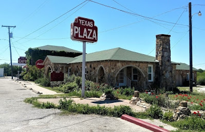
Arriving in Decatur, Texas, we made a "must-do" geocaching stop for a roadside attraction Americana history. "Petrified" (GC3X4ZF) is located at the Texas Tourist Camp Complex. From the historical marker: Local businessman E.F. Boydston (1888-1945) purchased this site, a former seed lot, in 1927 for $400. Recognizing a potential business opportunity in offering services to the traveling public, he built a wooden shed and gas station in 1927. Travelers were allowed to build campfires during overnight stays, and by 1931 Boydston added three wooden cabins with garages to the camp complex. The buildings were later faced with rock, and more cabins and garages were added in 1935. The original wooden gas station (photo at top of page) was covered with petrified wood in 1935 when the highway was widened and remained in operation by the Boydston family until 1988.


The Texas Lunchroom, a one room frame building, was built in 1929. Renamed The Texas Cafe in 1935 and refaced with stone to match the other buildings in the complex, it was enlarged to provide second floor living quarters. Popular with local high school and college students, as well as families and the traveling public, it was closed in the 1960's after a highway bypass built west of town diverted traffic from this area. The cafe re-opened in 1993. One of the few intact examples of tourist camps built throughout Texas in the mid-20th century. This property is significant for its association with the early development of automobile tourism.


Our last stop, also in Decatur, was for the geocache "Goin' to the Chapel" (GC198AR). The Episcopal Church of the Resurrection is the oldest original church building in Decatur. Consecrated by great missionary Bishop, the Rt. Rev. A.C. Garrett. Erected facing Main Street (2 blocks west of square) in 1889. Known as "the little church with the crosses", by 1912 it had deteriorated, but it was restored and moved facing Walnut Street.

In 1940 the building was sold and used as a mattress factory. Then it was rescued the same year and moved to this location, with the sanctuary placed symbolically to the east towards Jerusalem.


So that's it for today's roadtrip back home from Oklahoma to Texas. Thanks for riding along with us. Feel free to leave your comments and/or share our adventures with your friends. You can find us on most social media platforms:  FacebookMeWeParlerGabTwitterInstagramMAGAbook, and Reddit. Follow us on any or all of these platforms.

See you next time...