Showing posts with label New Mexico. Show all posts

Sunday, February 26, 2017

2017-02-26: FINALLY Geocaching Again Grabbing Some Caches in Hobbs, NM

WORK WORK WORK WORK WORK!!! That necessary evil keeps getting in the way of our fun hobby! For the past 2 months or more, I've had to work 6 days a week. Including drive time that's 70+ hours a week! That doesn't leave much time for Geocaching and sight seeing!

Browsing through the cache listings for events and other recent hides, I discovered a yet un-found cache up in Hobbs, NM that has been there a week. Knowing that it is difficult to get motivated in the morning when you only have one day to sleep in, I contacted a co-worker (Noerjr) to see if he wanted to go caching too. He agreed and now we have no excuses but to get going out the door.

Looking up other caches of interest in Hobbs and along the way there, I discovered another yet un-found cache between Seminole and Hobbs along US-62.

So we drove over to Odessa and met up with Noerjr at Starbucks. After grabbing a couple coffee's, we drove off heading up US-385. An hour later we were on US-62 westbound approaching the roadside picnic area and rest stop. Quickly finding the cache (GC70TG1) and the nice clean log sheet! WOHOO a FTF!! (First to Find)

Our next stop was at the Gateway Arch New Mexico Style (GC3A6RN)! Another quick roadside park and grab, but also a photo opp for the Welcome to New Mexico sign.


Then a couple miles later, we entered the town of Hobbs, NM. You know I think New Mexico must be called the "Big Sign" state! As we entered Hobbs, we were also greeted with another big sign. Here we found two caches "Flea Bag Inn" (GC48M83), a travel bug hotel cache, and the "Old Wood Windmill" cache (GC42QJ2). This also gave me the opportunity to finally drop off a Travel Bug which I've been holding since last November. I feel guilty for hanging on to it for so long, but haven't had the chance to place it in a cache.


Our next stop was for the newly placed "Gold Junction" cache (GC70VYV). A nicely hidden cache for another new cacher in the Hobbs area. I'm sometimes a little hesitant looking for a new cache placed by a cacher with few finds. (only 17 for this one) Sometimes the coordinates may be WAAAYYY off or the container not even there! But this one was a good hide. Well done Boogieman77!

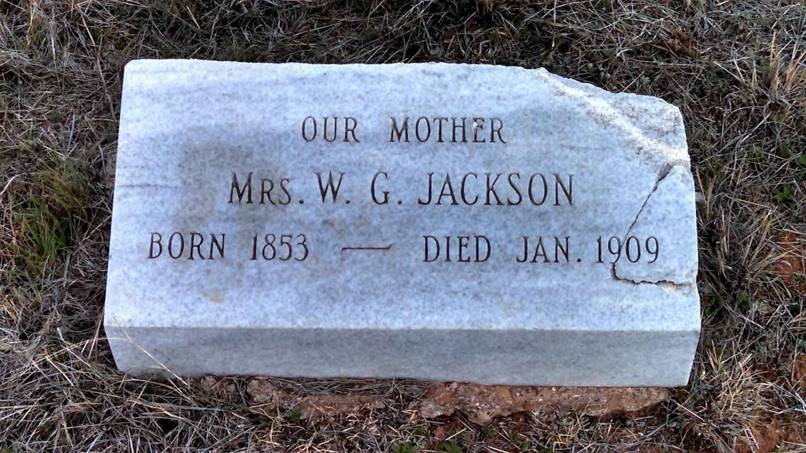
Then up the road to a 6-stage Multi-Cache (GC1X8ZF) at the cemetery. This one was a lot of fun. Started at the front, then to the back, up near the front, you get the idea! Criss-crossing back and forth across the cemetery looking at graves to get hints to the next set of coords. Rated a difficulty of 5, but a fun cache.

Next was another Multi-Cache called "Why Did the Chicken Cross the Road?" (GC3QKHK). Although the 10' chicken statue was no longer there, we did manage to find the egg at the end.

After some fun, it was time for some history. The next cache was called "Ye Old Slammer" (GC1WWNC). This was the Old City Jail from the 1930's. Couldn't see much as it was all boarded up. Too bad. They should make this into a museum or something.


One more cache in town before heading back and we made it a virtual cache (GC3DAE). Located at the old oil well from the 1920's celebrating SW New Mexico and the Permian Basin economy. There's also another historic feature here, but I can't say because that would give away the answer required to claim a find. And that would be cheating! HAHA!


Two more quick roadside park and grab caches on the way back to Odessa (GC24RE6GC1YEFJ) and that was it for the day. It wasn't a big day for caching with a lot of sites, but it was a much needed break from WORK WORK WORK WORK WORK!! And had a great time with Noerjr who previously only had 1 find and ends his second caching day with 12! Way to go!!

Hopefully soon I'll be back to a 5-day work week and we'll be caching on a regular basis again! Until next time...

Sunday, September 18, 2016

2016-08-21: Standing on the corner of Texas and New Mexico

Welcome back! Today we headed north up into New Mexico for a couple more First-to-Finds (FTF's) and a few other Geocaches along the way.

Our first stop was a little town about 20 miles north in Wink, Texas. Known for being the hometown of Roy Orbison from the age of 10. He started his first band while attending high school here. There was a historical marker there at an empty lot which we assumed the house once stood.

After reading the sign we drove to the nearby community park and our first cache (GC6QCTC). Another new Geocache placed by MedicoJoe and another FTF for us. This was a nice park and we walked the entire perimeter to take pictures of the Looney Tunes character statues on display. 


Our next stop was just on the outskirts of Wink. There along the roadside sits a historical marker for the Old Wink Cemetery (GC6QK7Z). The exact locations of the individual graves are not known. The Old Wink Cemetery is the burial site of 26 persons who died during the early days of the oil boom, 1926-1929. Shifting sands over the years have erased all vestige of the graves. According to the old timers in Wink, the cemetery is located in the Monument Draw. Although it is dry now, during the 1950s - 60s it was flooded with oil field runoff water and the area was under water for over 10 years. Several of the Wink residents remember fishing and hunting here. There are no current signs of the cemetery today. It is part of a local ranch.

As for the Geocache, we searched for about 15-20 minutes but came up empty. We found the rocks from the hint given, but no cache container. I believe it was too close to the historical marker and muggled by someone stopping to read the sign. (As a side note, we did find the cache two days later after the MedicoJoe replaced and moved further away from the sign. Another FTF!)

Continuing north for a few more miles, we reached the state line between Texas and New Mexico and our next cache (GC6QK3N). Another new cache placed by MedicoJoe and another FTF!

The next town was called Jal, NM and our next cache was at the Jal Cemetery (GC6QK3B). In the 1880s, several brothers brought a herd of cattle to Monument Draw, six miles southeast of the present city. The cattle were branded with the initials of the previous owner (John A.Lynch) and the cattle soon came to be called the JAL Cattle. The men who worked the herd referred to them as the Jal cowboys. In time the name became synonymous with the settlement itself. Though after finding the Geocache, a quick walk around the cemetery and we didn't notice any old graves so we didn't take any pictures. But we did get another FTF!

Closer into the center of town was a community park and another FTF (GC6QK43).

Driving SW on Hwy 205 a few miles to a town called Bennett, NM was our next Geocache (GC2H0NE). This next cache was a piece of history which goes to show how government usually makes matters worse and not better:
Here are the ruins of a whole way of life, apparently gone forever. This “camp” was started in the middle 1930’s when the natural gas boom sprouted out of the oil boom. In the 1940’s the pipeline system was finally becoming part of the infrastructure we know today, but even then you could drive from Jal to Odessa and beyond at night just by the light of the flares that were burning off the natural gas so they could pump the oil. Then the natural gas became valuable and furnaces, stoves and even “ice boxes” (refrigerators to you newbies) were powered by natural gas. 
El Paso Natural Gas Company Jal #1 plant was built to collect, treat, and pump natural gas all the way to California. To support the plant, houses were built for the employees and their families. An instant middle class was formed by the camps that sprouted all over the oil fields. Other companies like Phillips, Shell, and Texas-New Mexico quickly joined suit. Jal, New Mexico was then advertised as the “Gas Capitol of the World”. More natural gas flowed through these companies’ pipelines here than anywhere else in the world.
The plants were unique communities. Every employee had a house as a benefit of employment. Every house had indoor plumbing, free water, free electricity, free garbage collection, and of course, free natural gas! It was a Company Camp. The plants had to make their own electricity to run, and the camps benefited. The plants had to obtain their own water and the camps benefited. The houses were built and owned by the companies because the plants ran 24/7 and the workers were conveniently nearby working shifts. The kids that grew up in the camps virtually lived in a large family setting. Everybody knew everybody and lived in a homogeneous mix of mothers, fathers, brothers and sisters where we learned to get along. We still get along and call ourselves Camp Brats. 
Jal became sort of a Company Town, with many plants surrounding it and the Main Offices located there. The Company built a golf course. The Company built the Clinic and hired/attracted a doctor to come to Jal. Company ball teams were formed. 
The tax structure of the State, at the time, benefited Jal, New Mexico. The oil and gas royalties off the School Lands in the area went directly to the local schools. Jal had a great school and great teachers! Virtually every Camp Brat had at least an opportunity to go to a college or university, and most of us did. Life was good, life was great! What could go wrong? 
The “Government” is what went wrong. Local, State and Federal government intervention went wrong. Free houses? Can’t have that, there aren’t any taxes paid. Free water? Can’t have that, there aren’t any taxes paid and it is just not fair to everybody else, so they said. Same for the electricity, the utility companies just weren’t getting their cut. State school land taxes were shifted to the general fund and Jal lost most of its school funding to the northern population centers of the state. 
By the 1970’s our way of life was falling apart. By the 1980’s the camps were being broken up and the houses torn down and/or moved away, lock, stock and barrel. What you see left here 20 to 30 years later is government’s handiwork.
Continuing north again going through town we came to our next Geocache which was a multi-cache (GCJ77H). It also brought us to this huge work of art. "The Trail Ahead" was sculpted by local artist Brian Norwood and dedicated in September of 2000. The statues consists of seventeen metal silhouettes stretching for approximately 400 feet. The largest measures over twenty feet tall! They honor the ranching heritage of Jal, New Mexico.


Circling back around towards the south and back towards home, we come to our next cache (GC2AB0) and the corner of New Mexico and Texas. The COMPROMISE OF 1850. The results of the Mexican War (1846–48) brought Texas into serious conflict with the national government over the state's claim to a large portion of New Mexico. The claim was based on efforts by the Republic of Texas, beginning in 1836, to expand far beyond the traditional boundaries of Spanish and Mexican Texas to encompass all of the land extending the entire length of the Rio Grande. Efforts to occupy the New Mexican portion of this territory during the years of the republic came to naught.

After numerous unsuccessful attempts to resolve the issue, Senator James A. Pierce of Maryland introduced a bill that offered Texas $10 million in exchange for ceding to the national government all land north and west of a boundary beginning at the 100th meridian where it intersects the parallel of 36°30', then running west along that parallel to the 103d meridian, south to the 32d parallel, and from that point west to the Rio Grande. The bill had the support of the Texas delegation and of moderate leaders in both the North and South. Holders of bonds representing the debt of the Republic of Texas lobbied hard for the bill, for it specified that part of the financial settlement be used to pay those obligations. The measure passed both houses of Congress in the late summer of 1850 and was signed by President Fillmore.
This square marks the corner that divides the two states. While I'm standing on the New Mexico side, Candy is standing in nearby Texas! Maybe not as cool as Four Corners, but still cool.

Our last Geocache of the day (GC69XEN) was at the Sand Hills. Mapped by U. S. Government, 1849, for gold seekers and settlers. Known earlier to Indians and many Spanish explorers. A 100-mile belt of sand in Winkler and 4 other Texas counties and in New Mexico. Width varies from 3 to 20 miles; outer dunes are held by dwarf oaks. Water at 2' depth supports willows, cottonwoods, and a plum thicket. (The plums gave food to early settlers.) Many dunes more than 70' high. Heavy, shifting sands a natural barrier to travel. Campsite and game reservation for Indians. Now part of expansive cattle ranges and rich oil fields. Being from Florida when we saw this much sand it usually had a large body of water on the other side.


So that was today's Geocaching Adventure. We hope you've enjoyed it and maybe learned something new. Perhaps it has also inspired you to get out and explore the area around you.

Sunday, July 17, 2016

2016-07-02: Being Attacked by Alien Birds in Roswell, New Mexico

Hello and Welcome Back to AwayWeGo's Geocaching Adventure Blog. Today's adventure had us going up into New Mexico and was supposed to be deep into the earth at Carlsbad Caverns. However we forgot that it was a holiday weekend and it was very busy! So we decided to skip it for another day and continue up the road to Roswell, NM to see if we can find some extraterrestrials.

Our first Geocaching stop was near the town of Malaga at a New Mexico historical marker. (GC2AXZ6) The marker was to highlight the travels of Don Antonio de Espejo, leader of the third expedition to explore New Mexico, who passed near the spot on his return to Mexico City in 1583. After learning of the martyrdom of two Franciscan friars from an earlier expedition, he explored the Pueblo country and then followed the Pecos River Valley south.

Soon we arrived in the galactic rest stop of Roswell, NM only to find a packed downtown area due to the annual UFO Festival! Just not going to be our day. The line for the UFO Museum was out the door and down the block. I looked at the phone and found a nearby cache away from the activities that would also give us a moment to park and figure out what to do.

Arriving at our next Geocache (GC3A0KF) at the James Phelps White House. Built in 1912 and lived in by the family until 1972, the house was donated to the Historical Society of Southeast New Mexico in 1976. Now it is a museum.

Today the museum was closed, but we pulled in to find a car parked there with two ladies inside, probably in their 60's, and looking at us rather inquisitively. Were they also Geocaching? I parked about 5-6 spots away from them. After a minute or two, she pulled over closer about two spots away on my side. We stayed in our car and I just continued looking at my phone like I was texting. She then back out again and pulled up right next to us on Candy's side and rolled down her window. We then noticed she had cuts on her face and was bleeding. She proceeded to warn us about a bird that had swooped down and attacked them. This was the reason she had cuts on her face. We thanked her for the warning and they left.

Well being so close to the cache, I didn't want to leave without an attempt. The parking lot was about 100' from the cache location. We looked out the window but didn't see any bird flying around. I opened the door and looked some more. Nothing. A few SECONDS after standing up and looking around, this bird comes out of nowhere swooping down to about a foot above my head! I quickly jumped back into the car. There IS an alien attack bird out there on the loose! Now what to do?
Looking carefully we noticed a driveway running right along side the house and around back. So I pulled out from the parking lot and into the narrow driveway until I was just a few feet from the cache. Now we had some protection from the car, the house, and an overhang. I quickly jump out and spotted the cache. I brought it back to the car where I stamped the log sheet and placed it back. WOW! We've been on hikes with the threat of snakes, alligators, scorpions, and now Attack Birds from Outer Space! Let's get outta here!

Back over to the main street through town where we managed to find a place to eat. A Mexican restaurant with slow service and just OK food. Nothing special but we were hungry. After lunch, we quickly strolled through the two blocks of festivities for a look. Mostly arts & craft booths with some alien stuff added to the mix. One of the most creative displays was this one guy who turned old tires into alien creatures, plants, and other objects. These were my distant relatives, the Goodyear family, from the planet Yokohama of the Uniroyalverse. On the drive out of town we stopped for gas and had my picture taken with a very patriotic visitor.


Heading south and back towards home, we stopped in the town of Artesia, NM. I noticed on the drive up a couple of statues along the roadside but didn't stop. But since Carlsbad and Roswell were packed full of tourists, I decided to stop here. The first one pictured below is called "El Vaquero" (the cowboy) and is firing a warning shot from his pistol into the air the warn the "Trail Boss" of the second photo that he has spotted some cattle rustlers coming their way.


The next two statues were also virtual Geocaches. The first virtual cache (GCGJGK) brought us to the First Lady of Artesia Sallie Chisum, a school teacher, reading a book to kids about outlaw Billy the Kid.


The next virtual cache (GCJC1X) commemorates the first oil well in Southeast New Mexico and the men who made it happen. The two men are John Gray and Mack Chase who were in the industry for many years. Below that is a statue that depicts the first oil well from 1924.


One last Geocaching stop (GC2CR17) for the day at a cemetery near Lakewood, NM. A small cemetery dating back to 1906. By now it was hot and we were wanting to get back, so we forgot to take some pictures.

When we finally made it back down to Carlsbad, we decided to take a different route the rest of the way. We headed east along Jal Highway (128) and happened to pass by these lakes. They appeared to be salt water lakes and then noticed a sign for a salt mine. It's kinda hard to see from the photo and we didn't find any path to get down closer to the lake, but it looks as though that "white sand" around the edges was salt. There were also some parts that had tree stumps and other debris sticking up and they were all white and covered with salt also.


But that was our Geocaching Adventure for the day. Not what we had originally planned, but being spontaneous isn't bad either.

Friday, March 11, 2016

2016-03-10: Geocaching and GeoArt Getting an "A" For My Effort

Today I had to drive up to Clovis, NM to take care of some business and on the way back decided to go Geocaching. But first I had to grab one cache in Clovis since it was 100 miles away from Lubbock. Gotta keep my cache-to-cache distance miles growing. Last I checked it was over 411,000 miles! So a quick LPC next door to where I was and headed back.

Just south of Littlefield, TX was this GeoArt that I've had my eye on. A few days ago, I solved all the puzzles so I could get the correct coordinates to the caches. Driving down the rural dirt roads through farm land with rarely a muggle in site, after about an hour and 30 caches later, I spelled the letter "A" in Geocaches. Most of them were fairly easy with a couple of difficult nano's in the mix.

That was it for today. Hey it's a weekday! See ya next time.

A photo of the letter "A" GeoArt.

Sunday, March 6, 2016

2016-03-05: From Earth Texas to Billy the Kid in New Mexico

What a day! I think we drove about 400 miles all together. I mean we DID drive to Earth and back! Saw some strange things, learned a lot of history, and met up with Billy the Kid. Geocaching does take you to some pretty unique places.

After several quick roadside Geocaches, our first cache of interest was at the Halfway Cemetery (GC5NEFE). Now, I'm not sure what it was halfway between but the thing that comes to my mind is a Catholic cemetery for those in purgatory. Or maybe zombies? I don't know...

Actually the Halfway community developed around a school establishment in 1909. The name signifies its location between the county seats of Plainview and Olton. A post office operated in Halfway from 1910 to 1914. In 1945 the community had a school, two churches, a cotton gin, and a population of twenty-five. The school closed in 1952, and the building is now used as a community center. In 1980 Halfway had a gin, an agricultural equipment plant, churches, several businesses, and a population of seventy. In 1990 and again in 2000 the population was fifty-eight.


Since we've gotten halfway there... next stop is Planet Earth! (GC3H4VG) And now we know the question that has baffled scientists for many years. No, the earth is NOT millions and billions of years old. Nope, the Earth was established  in 1924. Everything in the history books before that was just our imaginations.

Earth, Texas was established by William E. Halsell, who laid out the townsite in 1924. Originally Halsell named the city Fairlawn, but in 1925 it was renamed Earth when it was learned that there was already a town in Texas by the name of Fairlawn. In order to find a new name the townspeople sent in suggestions, and the agreed-upon best name was chosen.

They even put the name on this huge tower so all the UFO's and space aliens headed over to Roswell know where they are.


Now our next cache was about 100 miles away across the state line into New Mexico. We wanted to make sure we got to it today, so we skipped all the others between there and will grab as many as we can on the way back. So we continued west on US-70 onto US-84 all the way out to Fort Sumner, NM.

Our first stop and next cache (GC8493) is who made Fort Sumner famous. This virtual cache brought us to the grave sight of the wild west outlaw Billy the Kid. Not exactly a good photo of the headstone, but his headstone was stolen twice! The first time it went missing for 26 years before its location was discovered. Within the large cage are three graves belonging to Billy the Kid and his friends Tom O'Folliard and Charlie Bowdre. After Billy the Kid's headstone was recovered the second time, a cage was built around the entirety and the headstone itself bolted down at the foot of his grave.


There are several more gravesites here at the historic Fort Sumner site. Here are just a couple samples.


There were four more Geocaches located in the town of Fort Sumner. One at the Billy the Kid Museum (GC29XY8), the Fort Sumner historical marker (GC1P67K), and two more at the main cemetery in town (GC60CPY and GC60CR4). And now that we've gotten all those, we still had 162 miles and more caches to get on the way home!


On the way back in another old town of Taiban we found our next three caches. The first one was the former trading post, former antique store, and now just former and abandoned business (GC34E7G). The Taiban Trading Post was built in 1915 and was once a thriving business.


The next cache in Taiban was the End of the Road (GCV8MZ). Here sits the remains of the First Presbyterian Church of Taiban. Completed in December of 1908 at a cost of $250, its first sermon was presented by the Reverend John R. Gass. As the towns population dwindled due to the depression and drought, the church held its last service in 1936.

As we arrived here, we see a pickup truck with Texas plates on it and a guy with something on a stick walking towards the church and right into the front door. I thought maybe another cacher holding a car GPS. I walk down the side of the church towards the back looking for the cache and he went all the way through the church and is out back. I ask him if he's Geocaching and he says he was taking a video. We get to talking and it turns out he's on vacation from Germany and traveling through Texas and New Mexico for 12 days. We chat for a little while and wish each other safe travels.

On the eastern edge of town was our next cache at the Watering Hole (GC1RVY1). This once liquor store, maybe even a bar is now half burned down. Once a destination for the thirsty, now only a destination for Geocachers.


Continuing eastbound was our next cache (GC617HR) and piece of history. At noon on November 30, 1944, a World War II supply train hauling 165 five-hundred-pound bombs headed for the Pacific Theater derailed in Tolar. The train caught fire and the bombs exploded. The blast, which leveled nearly every building in town, could be heard 60 miles away. It vaporized 500 feet of track and sent a 1,500-pound axle crashing through a store and rolling out the back. One person, Jess Brown, was killed in the explosion after a piece of iron shrapnel struck his head.


Our last cache for the day just west of Clovis, NM was located at the Blacktower Cemetery (GC61N67). Located west of the Chavez West Housing addition near Cannon Air Force Base, the cemetery is considered to be a lost cemetery and shows signs of not having been kept up for a long time. Tall grass, weeds and stickers guard the entrance to this piece of eastern New Mexico's history, but at one point airman from neighboring Cannon Air Force Base turned out to restore and clean up this treasure. 
According to a June, 2009 article, 25 volunteers showed up to the cemetery to clear away the weeds and shovel away the sand that had blown over the headstones. In the six years since the service project, the cemetery has fallen back into its forgotten, buried state. Railroad tie steps still exist and lead visitors to the entrance of the cemetery where several headstones are visible, but extremely difficult to get to.

According to a May 22, 2009, Clovis News Journal article, the Blacktower Cemetery was originally started as a family cemetery and became the final resting place for 42 individuals. The article cites local High Plains Historical Foundation member Harold Kilmer as saying that Blacktower is unique because research suggests that two Civil War veterans are buried there: Emmett Fulkerson, who died June 17, 1911, and William Brantley, who died Feb. 7, 1908. Kilmer said the cemetery was started by an unknown farmer’s family about 1906 after an infant’s death.


After looking around the cemetery at some of the headstones, we finally arrive in Clovis, NM and a wide variety of restaurant choices! You would think by now we would have learned to pack a picnic lunch for our adventures. Because having past through Clovis heading west out to Fort Sumner, spending time in Fort Sumner, then driving back to Clovis, there's not much for places to eat! By now we're practically starving! 

So we grab a quick sandwich at Subway before driving the two hours back to Lubbock. We ended the day with 16 Geocaching finds and a new county in New Mexico. And another day of adventure through history.

Thursday, March 3, 2016

2016-03-02: The Ultimate Gadget Cache!

In my ten years of Geocaching, it's always nice to come across a creative cache. Early on in the years they were few and far between. But these days they're getting more frequent and even more creative. They've even got an "unofficial" category for them called Gadget Caches.

And today I think I have found one of the best that I've come across so far. It's called the Ultimate Gadget Cache (GC5RDMC) and it's located in Clovis, NM. Looks like a simple box right? A regular sized cache. There's a reason there's a bench there. It gives you some place to sit while you figure out how to get it open! It took me about 30 minutes to finally access the log book!

The one end is blank, the other end has a key lock on it, and there's a hidden panel on the side. This was a fun 3-stage, maybe 4-stage depending upon how you look at it. The photos I have below I don't think are spoilers. Upon my first inspection of the gadget cache, I knew these doors had to open. I just had to figure out HOW to open them. What a great, fun cache!


Friday, February 26, 2016

2016-01-17: Geocaching Along the Texas and New Mexico Borders

So today was a Geocaching day to pickup where we left off yesterday. Picking up new counties and Geocaches of interest along the West Texas and New Mexico borders. We headed west on US-62 down into Brownfield, TX and turned onto US-380 westbound in Terry County.

Before arriving at our first Geocaches for the day, I saw a historical marker on the side of the road. As we are driving around exploring new areas, not only is Geocaching a good way to find places of interest but also the historical markers. So we pulled over to find that the building before us is what remains of the ghost town of Tokio. There were two towns in Texas that went by the name Tokio. (correct spelling) During WWII, the other changed it's name to Wiggins.

This town kept the name. The first school was built in 1911. Tokio was granted a post office in 1912. In 1929, Tokio had a population of only 15. It's record high population was in the 1940's with 125. Over the years, larger school buildings were constructed until the school finally merged with the Brownfield School District after the 1945-46 school year. There are still a few residences in the area, but the town officially folded and all that remains is the old school building.


Stopping for three quick caches in the town of Plains, we continued west on US-380 to the state line. There were several caches located near the state line. The most interesting was a virtual cache (GC41C6) at the memorial for the founder of the now ghost town of Bronco, TX.

At the age of 13, Herschel Robert Field saddled his horse, left his home in Batesville, AR and braved his way through Indian territory to become a cowboy in West Texas. In 1891, he began working for the T Fork Ranch in Wichita County, Texas and later the XIT Ranch. He eventually decided to move to Arizona, but along the way he was attracted by the grazing lands in Western Yoakum County. Field saw this area as a place where a cowboy with limited means might start his own ranch. In 1903, he purchased some land and started a store right at the Texas-New Mexico line.

Soon after he opened the store, he applied for the rights to a post office. He secured the post office from the agency in Washington, but they rejected the name. A traveling salesman suggested Bronco after seeing a cowboy ride a wild horse. And that's how the town got it's name. Settlers began congregating around Field's store in Bronco. By 1912 the population grew to about 25. At it's peak in the 1960's, the towns population grew to 180. Today there are only about a dozen residences scattered about and all the businesses have closed.


Continuing west on US-380 and into New Mexico, we entered into the town of Tatum. There was a metal fab shop there that made all kinds of sculpture and signs and we just had to pull over for a couple of pictures.


We found a few Geocaches in Tatum and turned north on Hwy 206 picking more caches every now and then. Now most of the time, you tend to find unusual out of the way sites because another Geocacher has placed a cache nearby causing you stop. But along this highway, we found one of the Roswell alien crash sites. Well maybe not really, but there's a farmer with a sense of humor!


Local wildlife.
One of the caches along the way was inside a 100 Grand Candy tin (GC5JBT5) at the entrance to the Candy Oil Field Service Treating Plant. And of course with Candy being named Candy and the company being named Candy and the cache having a candy theme. OK, well you get the idea...


We continued up Hwy-206 to Milnesand and turned back east on Hwy 262, eventually picking up Hwy 114 back to Lubbock. Overall we found 17 caches and a few more new counties. But best of all we had a nice drive through history.