Showing posts with label Air Force Museum. Show all posts

Sunday, August 7, 2016

2016-07-16: Geocaching Through Stone Artwork, a Cemetery, and a Train Robbery

Hello again and welcome back to our next addition to the AwayWeGo Geocaching Adventure blog. Today we're heading to the southeast Permian Basin of West Texas to find Geocaches in both Terrell and Crockett Counties. This will finally complete our Permian Basin Counties and qualify us to log a find on the PBC Challenge cache (GC2MX53).

But before we get to caching, coffee time. No Starbucks though. That's going east. First we drive south down to Ft Stockton and the Clockwork Coffeehouse. This is Candy's first stop before going into work each day. It's a nice little coffee shop with some delicious scones! It's my first time here and now I know why she likes it. 

From there we drive south on US-285 towards Sanderson, TX and US-90. Our first two caches (GC32891GC293FW) in Sanderson involve artwork on stones. These pieces of art displayed in two parks depict the life and history around Terrell County.


Originally called Strobridge, Sanderson began it's history in 1881 with the construction of the Galveston, Harrisburg, and San Antonio Railroad. With only a few sheep ranchers in the area at the time, it became the midway railroad depot between San Antonio and El Paso. The town began to flourish with the influx of hundreds of railroad workers and the increase in sheep and cattle ranchers as it became a major shipping location for livestock.

When Terrell County was created in 1905, Sanderson became the county seat. Another big boost to the economy came with the invention of he automobile. In 1922, the San Antonio to El Paso Trail became Texas Highway #3 and later US-90, the main route in the south between the east and west. Businesses of all types began to pop up as travelers began to stop here. The community continued to thrive with a maximum population growth of about 3,000 in the 1950's.

On June 11, 1965, Sanderson encountered a devastating flash flood killing 27 people and destroying numerous houses and businesses. Over the years with the boom in automobile travel, passenger railroad travel was on the decline. And in 1970 the Southern Pacific Railroad turned over it's passenger operations to Amtrak and focused on it's freight operations.

And if you're familiar with the animated movie CARS, then you'll understand the next blow to the town came with the creation of Interstate Highway 10 to the north of town. Travelers abandoned the slower pace of US-90 for the express I-10, bypassing the Sanderson.

The final setback came when the railroad moved all it's crew operations further to the west in Alpine which uprooted and relocated many families. Though Amtrak still makes a stop in Sanderson, no passenger facilities were maintained and the old depot was eventually demolished in 2012.

Today only about 900 residence still call Sanderson home. One of the remaining evidence of a past boom town, is the Kerr Mercantile building. Joe Kerr opened his store in 1892 which grew over the years. Also a successful rancher, he eventually built this corner mercantile building in 1927 which sold everything from hardware to groceries to the community. The Kerr family continued to operate this business over the years until the eventual close in January 1999 due to the decline in population.


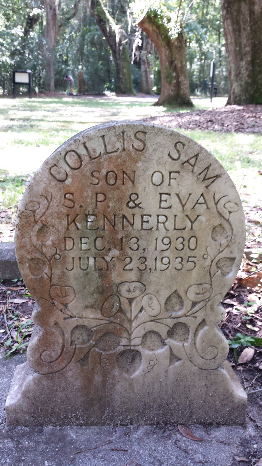
Heading east on US-90 on the outskirts of Sanderson, we stopped by the cemeteries for our next Geocache (GC638RP) and some more history. There were segregated cemeteries. Cedar Grove Cemetery for the Anglo Americans and the Santa Rita Cemetery for the Hispanic Mexicans. As with the more eastern south having segregated whites and blacks, here the Mexicans were segregated not only in the cemetery but once had to sit in the balcony of the old theater among other establishments in town.

One of the notable burials here are for Ben "Tall Texan" Kilpatrick and Ole Hobek. Once a part of Butch Cassidy's Wild Bunch Gang, Kilpatrick and Hobek tried holding up a train at Baxter's Curve in Terrell County on March 13, 1912. A Wells-Fargo employee was able to kill Ole with an ice mallet when he put down his gun to check his bag. He then grabbed the gun, shot and killed the Tall Texan when he returned to the same train car. This was the last train robbery attempt in Texas. They were buried in the same unnamed grave for a number of years and eventually the historical society placed this headstone in 1985.


Our next Geocache (GC11C1B) was a quick stop along US-90 in the middle of nowhere. Just a short hike up the hill to get a good view of the area. When we got back to our car and were ready to drive away, a state trooper pulled in behind us to see if we were ok. We said yes, we were just sightseeing and climbed the hill for some pictures. He said it is rare for somebody to stop along this stretch unless they were broke down or needed help. What can I say, we're not ordinary people!


Our next stop didn't have a cache, but it did have a historical sign and a photo opp. The U.S. Government first invested in Terrell County Aviation in 1919, with an airfield built west of Sanderson for the 90th Aero Squadron that flew biplanes for the border patrol. After the squadron relocated, the East Dryden Aerodrome was an active field until 1941. During WWII, American Airlines and the government joined to build a new civilian intermediate and emergency military landing field here. The Civilian Aeronautics Administration supervised construction that ended in October 1943. Later named Terrell County Airport, this facility has also hosted civil air patrol and military training exercises.


Next on the Geocaching list (GC2JKRG) and heading closer towards home is dedicated to Alley Oop. Located in Iraan, TX, this park highlights one of the towns most famous residents. Cartoonist V. T. Hamlin came up with the idea for the comic strip character while working in the oil boom here in the 1920's. Alley Oop, the strip's title character, was a sturdy citizen in the prehistoric kingdom of Moo. He rode his pet dinosaur Dinny, carried a stone war hammer, and wore nothing but a fur loincloth. He would rather fight dinosaurs in the jungle than deal with his fellow countrymen in Moo's capital and sole cave-town. Despite these exotic settings, the stories were often satires of American suburban life.


Along the edge of the park there is a blade on display from one of the many wind turbines in the area. These things look huge when they are standing tall, but even bigger when you're standing along side it! Now imaging that when the windmills are standing and turning, there are THREE of these blades rotating. That's some wingspan!


Well that's our day today. Join us again soon for another one of our Geocaching and Sightseeing Adventures. And remember, feel free to share our stories with your Facebook or Google+ friends, leave your comments below to say hi, and select the "Follow Blog" button to keep updated with our travels. Until next time, happy caching!

Sunday, June 19, 2016

2016-05-29: Geocaching Through Texas History, Cemeteries, and Ghost Towns

Hello again and welcome back to our Geocaching Adventures Blog. My work has started to slow down and we are able to venture out on the weekends to go exploring and geocaching around West Texas again. Although it is getting hotter, plus being exhausted, and finding the time to sit and write this blog too! Today's edition actually took place a few weeks ago and I'm just now getting around to tell you about it. So let me get to it...

On this Sunday morning, we picked up Candy's co-worker you might remember from hiking a few weeks ago. A few blocks away from her place was our first cache at the University of Texas of the Permian Basin. In reality, I was here a few days earlier to grab this Geocache as a "First to Find" since it had gone a couple of days since it was hidden without a find. Because of its location, I brought them here again to view the reason for the cache. Called "Unhenged" (GC6J85H), this cache was placed to bring you to a replica of the Stonehenge monument over in England. Saved us a flight overseas!


Out on the corner of the campus in Odessa near the street was this statue of a cattle rancher and a few of his herd. While waiting for the traffic light to turn green I snapped a photo. Then off to Starbucks for some coffee before the 84 miles to our next Geocache.


Our next few caches were in the Ghost Town area of Texon, Texas. (GC1Z34W GC113H9 GC1Z34Q) Early travelers along many historic trails in this area found the region arid and inhospitable. Given (1876) to the University of Texas, the lands around this area were leased to cattlemen. The Kansas City, Mexico & Orient Railroad built its line here in 1911, but did little local hauling.

Development came after Frank Pickrell and Haymon Krupp of Texon Oil and Land Company drilled for oil. Their driller, Carl Cromwell, brought in Santa Rita No. 1 named after the Saint of the Impossible and became the first gusher in the Permian Basin on May 28, 1923. The original tower was taken down and erected at the University of Texas and this replica was later erected in place.
Shortly thereafter Pittsburgh wildcatters M. L. Benedum and Joe Trees purchased some of the Texon Company's leases and formed the Big Lake Oil Company to develop the field. From 1924 to 1926 the BLOC president, Levi Smith, planned and built Texon for employees and their families south of the Kansas City, Mexico and Orient Railway tracks. At a time when oil towns denoted wildness, Texon was considered a model oil community. In addition to houses, BLOC provided a grade school, a church, a hospital, a theater, a golf course, tennis courts, and a swimming pool for its residents, who numbered 1,200 in 1933. Smith, an avid baseball fan, sponsored the Texon Oilers, a semiprofessional team composed of company employees. Privately owned businesses housed in company buildings included a drug store, a cafe, a boarding house, a tailor-shop, dry-goods and grocery stores, barber and beauty shops, a service station, a dairy, an ice house, and a bowling alley.

By World War II oil production was declining, and with no new wells, fewer employees were needed. By 1952 the population had fallen to 480. In 1956 Plymouth Oil Company, another Benedum-Trees property, took over BLOC, and in 1962 ownership passed to Ohio Oil, now Marathon Oil, which chose not to maintain the town of less than 100 residents. In 1986 the post office was closed, and in 1996 less than ten people lived in Texon. The population was twelve in 2000.


Our next Geocache (GC113H6) was another Texas Ghost Town. Reagan County, West Texas Highway 67 Between Big Lake and Rankin Named for an Englishman who was a shareholder in the railroad, Best was nothing but a switching point on the Orient Railroad. When oil was discovered in 1923, Best mushroomed as the regional supply center. The population grew to an estimated 3,500 in just two years. Best gained an instant reputation for being a wild town. Perhaps added by the irony of its name and a novel (The Big Fist) written in 1946 - set its bad reputation in stone. The town's unofficial slogan was "the town with the Best name in the world and the Worst reputation." After the boom fizzled, only 300 people were left in the 1940s. A service station / post office was still in operation in the 80s and by the 1990 Census - only 25 people were left. It is now listed as 0001. Best was located at Hwy 67 and Best Lane, between the highway and the train tracks located about a block south. Best Lane turns north off of 67, and is called Lone Wolf Lane south of the highway. Santa Rita Road runs parallel with and between the highway and tracks, and goes to the Santa Rita No. 1 well. Nothing left but a few foundations along the Santa Rita Road.

Further down the road was the Ghost Town of Stiles, TX and our next five Geocaches, including two virtual caches. The first three were located near the historical marker and the old courthouse. (GCXBWPGC9891GC113HD) Stiles is near the intersection of Farm Road 1800 and Centralia Draw, eighteen miles north of Big Lake in north central Reagan County. Areas of massive limestone are found in and near Stiles. The area was on the Butterfield Overland Mail route in 1859-61 and was settled by sheep and goat ranchers in the 1890's. The town was named for Gordon Stiles, who donated land for the townsite. William G. Stiles applied for a post office, which was established in 1894, and a store was operated nearby. Because it was the only town in the county Stiles was chosen county seat of Reagan County when the county was organized in 1903. In 1907 John Marvin Hunter began publication of the Stiles Journal, the first newspaper in Reagan County. By 1910 Stiles had a population of 191 and a frame courthouse.
The following year William Martin, of Comanche, built a new courthouse with stone quarried from a hillside near the town. In 1911 the Kansas City, Mexico and Orient Railroad bypassed Stiles in favor of a route through Big Lake. The original survey for the railroad included Stiles, but the right-of-way was changed to the southern part of the county when a rancher refused to grant permission for the road to cross his land. After the discovery of oil at the Santa Rita oil well near Big Lake in 1923, Stiles began to decline. Following an election on May 28, 1925, Big Lake became the county seat. By 1925 the population of Stiles had fallen to seventy-five, and by 1939 the post office had been discontinued. From 1966 to 1990 the population was estimated at sixteen.

The first floor interior plan of the courthouse was a Greek cross with intersecting center hallways and four corner rooms measuring 16' square. The stairway is located in the west hallway. The courtroom and two other offices are located on the second floor. Interior detailing includes plaster walls, simple door/window trim and baseboard, transoms over doorways and a wooden chair rail in the courtroom. The ceiling on both floors is pressed tin and the floors are wooden. A small raised platform is the only distinguishing feature in the courtroom. A limestone records vault is located to the east of the main structure. It was originally built to provide fireproof storage for the earlier frame courthouse that occupied the site. It has a stone barrel vault, but was originally roofed over with a shingle roof. The steel vault doors are still in possession of the owner. Christmas of 1999 an arsonist set fire to the structure and gutted the place.

Outside the courthouse and sitting on top of the cache container, we spotted our first scorpion since arriving in West Texas. While this one was just a baby at maybe an inch long, you gotta be careful and watch for the poisonous critters while caching out here. Between those and the deadly rattlesnakes, you can't just reach for the cache as soon as you spot it!


South of the courthouse was the Stiles Cemetery which is still used to this day and the other two caches. (GC113HJ GC9EFB) The cemetery opened in 1903. Three of the earliest graves are three siblings who died within 10 days of each other. The historical marker says that the people buried here in the early days were cowboys who were accidentally killed, victims of shootings and rattlesnake bites, and citizens who fell to dysentery epidemics. There is also a grave of a Spanish-American soldier.


Continuing east on US67 in Reagan County, we arrived in the county seat of Big Lake, TX. The town of Big Lake took it's name from the lake created by rain which gathers in a natural land depression near this cache (GCZF09). Once filled by spring-fed water, it is now the largest dry lake in Texas. In pioneer days it was the only fresh water between the Concho river and springs at Ft. Stockton and was a campsite for Indians, Mexican traders and cattle drivers. When there is enough rain in the area this lake still fills with water and when it does, there are live fish in it. In the photos below, you can see where the spring was in the first and the dry lake in the distance of the second photo.


The other two caches in Big Lake were at the Glenrest Cemetery (GC1Z348) with graves dating back to 1913, and at the Reagan County Airport for the Florene Miller Watson Memorial (GC17W89). During World War II, a hand-picked group of young women pilots became pioneers, national heroes, role models.. called Women’s Air Force Service Pilots. These ladies flew their way into the annals of women’s history as the first women in U.S. history trained to fly American military aircraft.

Florene Watson was born on December 7, 1920 in San Angelo, Texas. She grew up in Big Lake, Texas, where her father, T.L. Miller owned a jewelry store. In 1937, Florene graduated from Reagan County High School. Her first flight at 8 years old was in Big Lake in a World War I barnstormer plane. By age 19 she had finished two years of college and had also obtained a pilot’s license. Mrs. Watson earned her flight and ground school instructors’ ratings and was teaching men to fly in the War Training Program in Odessa and Lubbock, Texas, when World War II began.

Florene Watson was one of the elite group of only 25 experienced women civilian pilots who met the military requirements in 1942 and volunteered to fly for the Ferrying Command. They were called the Women’s Auxiliary Ferrying Squadron (WAFS). Almost a year later in 1943, their name was changed to Women Air Force Service Pilots (WASP) to include women pilots as they graduated from their military training schools in 1943 and 1944. Some of the 1078 graduates flew for the Ferrying Command, but most were assigned varied flying duties in the Training Command. Thirty-eight WASPS lost their lives during their service to the war. Mrs. Watson was the first commanding officer of the WAFS-WASP stationed at Love Field in Dallas, Texas. She flew all the basic Arny Air Corps trainers, fighters, and cargo planes, including twin and four-engine bombers, transporting them all over the United States for the Ferrying Command. In addition to her ferrying duties, Mrs. Watson tested radar equipment and served as a military airline pilot in 1944. Her favorite airplane was the North American Mustang p-51.

The next cache was located at the remains an old building in Barnhart, TX (GC17W1M). Barnhart, located off U.S. Highway 67 and State Highway 163 in southwestern Irion County, was established in 1910 at the building of the Kansas City, Mexico and Orient Railway and was named for William F. Barnhart, agent for the railroad. In 1912 a post office was acquired with C. C. Luther as postmaster, and the first school was established with Mrs. Maude Branch as the teacher. The Barnhart Independent School District was established on February 27, 1917; the school operated until 1969. By 1920 the town also had the Barnhart State Bank, which was moved to Rankin in 1927, and a newspaper, the Barnhart Range, published by Ed Downing. In the 1920s and 1930s Barnhart became a large-volume shipping point, due to its location between major railroad lines. The population was reported as fifty in 1915. In 1947 Barnhart had 250 residents and six businesses and in 1980 seventy-four residents, a business, and a post office. In 1990 the population was 135. By 2000 the population was 160. There's also the Barnhart Cemetery cache located east of town (GC1Z33B).


One of the favorite things we like about Geocaching are the odd things the caches bring you to see. This next Geocache (GC1Z355) was located along the roadside of this rock painted up like the American flag. If you were not caching and passing by at the posted 75 MPH, you might have missed this. 


Our last cache of the day (GC1Z35E) was located at the Mertzon Cemetery which serves the community of Mertzon and dates back to 1912.

So another great Geocaching day in West Texas and picking up a few more counties to boot! Thanks for following along and we hope to be off on another adventure soon.

Thursday, January 28, 2016

2014-06-09: Road Trip Day #3 Connecticut, Massachusetts, New Hampshire

On day three of our summer road trip to New England, we found 16 Geocaches in Connecticut and Massachusetts. Our first stop was this statue located in Windsor, CT. It is of Major John Mason who was born in England in the year 1600. He immigrated to the New World in 1630 and founded the towns of Windsor, Old Saybrook, and Norwick. He was the Magistrate and Chief Military Officer of the Connecticut Colony. He died in 1672. This monument was erected by the state of Connecticut in 1889. This is just another example of the great benefits of Geocaching. You learn so much history!

Across the street was the First Church, the oldest Congregational Church in Connecticut. Its beginnings trace to 1630 in Plymouth, England, where 140 men and women sailed on the Mary & John bound for the colony of Massachusetts. Hearing from the indians of the fertile land along the Connecticut River, a small contingent of settlers, including the above mentioned Major John Mason, headed southwest establishing the first Connecticut town of Windsor in 1633. In 1635 the First Church congregation ventured from the settlement in Dorchester, MA and joined the rest in Windsor, CT.

Next door to the church is the Historic Palisado Cemetery which is home to the oldest legible gravestone in Connecticut. That gravestone belongs to the Reverend Ephraim Huit who died in 1644.

Heading further north up the road along highway 159, we passed by this "Drastic Park" made from scrape metal on the side of someones front yard. After stopping for a quick photo opp, I checked my phone and lo and behold there's a Geocache located there as well! A magnetic hide-a-key located inside the mouth of one of the dinosaurs.


Just a few more miles up the road near the Bradley International Airport, was our next to Geocache stops. The first at the Connecticut Fire Academy and this memorial to the brave men and women who put their lives in danger for others. Next door was another cache at the New England Air Museum.


Crossing over into Massachusetts, we made it to our next Geocache located at the entrance to Forest Park, in south Springfield, MA. There we found what had to be a 20' totem pole carving of Omiskanoagwiak, the Wolf People Medicine Man of the Pioneer Valley Indians.


From there, we detoured a little to the east to grab another Virtual Geocache. Most geocaches have an actual container and logsheet to sign. A Virtual Geocache was allowed in the early days of caching for use where a container could not be placed. Like the above medicine man statue was a virtual. It required emailing some information requested from the plaque. But they no longer exist to create new ones and when one gets archived, it cannot be re-created. So we always look for these types and sometimes go out of our way just to find one.

The next one was in the town of East Longmeadow, settled in 1744 and known for its sandstone quarries. There we found a stature called "The Quarryman" honoring those who quarried red and brown sandstone from over 50 quarries during the 1800's.

From there we continue on I-91 north to Holyoke, MA and stopped along the Connecticut River to view the dinosaur footprints. This was the location of an Earthcache. Similar to a virtual, there's no actual logsheet to sign. You read and learn about the location and then email the required information.


A big lizard was here!
The trail leading to the dinosaur footprints.
The next stop on the list wasn't much of a photo opp, but a piece of history. The virtual cache location was a piece of land with a large boulder and plaque. The plaque reads: "This boulder stands on part of the original home lot of Moses Hutchinson, one of the first five settlers of Old Pascommuck. On May 24, 1704, Pascommuck Settlement was attacked by Indians. Of the 33 people then living in this region, 19 were killed, 8 escaped, 3 were rescued, and 3 were carried captive to Canada.

Further up the road gave us a chance to stretch our legs and do some hiking. The next several Geocaches were located within the 400 forested acres of Mt Holyoke and J.A.Skinner State Park. Upon the mountain was the Summit House built in 1851, a memorial for a WWII plane that crashed here, some great views, and even some early graffiti! Yes, there was a name and date carved on one of the boulders from 1873. This carving went undiscovered until the 1970's.


Two more stops in Old Deerfield and in Greenfield for two more virtual caches. Old Deerfield was Indian land called Pocomtuck, settled by men from Dedham in 1671. Attacked by Indians, burnt and abandoned in 1675. Reoccupied and attacked in 1704 by the French and Indians, who took 47 lives, and carried off 112 captives to Canada, of whom 60 were later redeemed.

Finally, we settled in for the night at the Riverside Hotel located right alongside the Connecticut River on the border of New Hampshire and Vermont. A beautiful view from our room overlooking the river and the end to another great day of Geocaching, adventure, hiking, and history.

The view from hotel room.

From the old bridge looking back at hotel.

Ain't she pretty!

Friday, January 22, 2016

2014-06-07: Road Trip Day #1 Florida to Virginia

YIPPEE! Vacation time! Which means a Road Trip is in store! We have only 4 things to accomplish while on vacation. Drop Candy's grandkids off at their fathers house in Maryland, get at least one Geocache each in Vermont and New Hampshire, and get a really cool Geocache at this old train bridge in Pennsylvania. The rest is purely spontaneous.

Our first stop after spending the first few hours driving north on I-95 out of Florida, is the Smallest Church in America. Located in Townsend, GA off I-95 at exit 67. this Smallest Church in America was built in 1949 by Agnes Harper and deeded to Jesus Christ.


Our next stop up the road just off I-95 near Savannah, GA is a very popular Geocaching Travel Bug Hotel. This one is more than just a larger Tupperware able to hold some trackables. This one took some creativity and imagination to assemble. It's even got a front desk, clerk, and rooms to check in to!


Next stop and not far away, is a virtual cache located at the Mighty Eighth Air Force Museum. Getting our picture with the F4-C Phantom gives us credit for finding the Geocache. This was one of 3 planes on the grounds and free to view.


Just across the border into South Carolina, rests the next virtual Geocache on our route. This 1910 wood burning locomotive was on display and a bit rusty!


Continuing our drive up I-95, we detoured again for a little piece of American History. The Sheldon Church Ruins was originally built between 1745-55. Then during the Revolutionary War, burnt down by the British Army. After the war it was rebuilt. However, only to be burnt down again by the Union Army during the Civil War! So they just left it as it was. Although it is still used today for special events and services. It must see place to visit the next time you're traveling up I-95 through South Carolina.


Next stop further up in Manning, SC was this mural painted on the side of one of the building in town. There are several murals around town that depict Francis "Swamp Fox" Marion and his battles against the British Army in and around Clarendon County.


Continuing northbound to I-95 exit 181 in South Carolina, we stopped to view this old cotton press built in 1798. Again another piece of history learned thanks to Geocaching.


Finally in an effort to make up some time from all the stops, we continued straight on through North Carolina and just into Virginia to find a hotel for the night. Time for some rest.
Until tomorrow...