Showing posts with label mill. Show all posts

Friday, February 18, 2022

2020-10-18: Westbound Roadtrip Through North Carolina and Tennessee

Westbound and down, eighteen wheels are rollin'.... OK, so there aren't 18-wheels. But our time in North Carolina has come to an end and I gotta week to start the next project in Guy, Texas. TIME FOR ANOTHER ROAD TRIP! Time for geocaching, sightseeing, and exploring more backroads and byways between here and there.

Today we drove all the way over to Chattanooga, Tennessee. We discovered an old mill, a waterfall, a giant Harley-Davidson, a copper mine, and a historic cemetery. So climb into the GeoJeep and let me show you...


Not to take up too much time starting out, I quickly drive up to I-40 and head westbound. The first few hours were nonstop all the way to Cherokee, NC and our first geocache (GCGYMA).

For 50 years, nearby farmers brought their corn and wheat to Mingus Mill, built in 1886. The miller usually charged a toll of one-eighth of the grain the customer brought for milling. The gristmill's stone was turned by a water-powered, cast-iron turbine. From water pressure built up in the penstock at the flume's end, the turbine generated 11 horsepower, enough to run all the mill's machinery. On the second floor, the smut machine blew wheat grain free of debris, while the bolting chest separated ground wheat into grades by sifting it through fine to coarse bolts of cloth.

Mingus was the largest gristmill in the Smokies. Its 200-foot-long wooden flume brings water to the mill's turbine. As early as the 1820's, more progressive millers began using turbines to power their mills rather than waterwheels. The Mingus family sold the mill to the National Park Service in the 1930's.


Continuing the scenic drive west on US-74, we headed for Juney Whank Falls and our next geocache (GCMBAZ). This puzzle cache requires gathering information along the 4.4 mile Deep Creek - Indian Creek loop trail. However once we arrived at the trailhead we weren't up for a long hike. So we just took the short hike to the first of several waterfalls for some photos.


Here's one of those reasons why I like driving the backroads and byways through rural towns and communities across this great country. Passing by Cherokee County Cycles, I spotted this HUGE Harley-Davidson custom motorcycle along with a couple of other cool vehicles in the parking lot. I just had to pull in and get a few pics!


Crossing over into Tennessee, we check out the Great Copper Basin Earthcache (GCNP87) and a new caching county of Polk County. In 1843, a prospector, hoping to find gold south of the Coker Creek mine fields, instead located one of America's richest copper reserves. Over the next century, American and foreign companies chartered more than a dozen copper mines in the Ducktown Basin. The last mines closed in 1987. Many of the buildings still remain today.


We ended our day in Chattanooga at the National Cemetery for two virtual geocaches (GC5148, GC4E66). On Dec. 25, 1863, Maj. Gen. George H. Thomas, “The Rock of Chickamauga," issued General Orders No. 296 creating a national cemetery in commemoration of the Battles of Chattanooga, Nov. 23-27, 1863. Gen. Thomas selected the cemetery site during the assault of his troops that carried Missionary Ridge and brought the campaign to an end. The site Thomas selected was approximately 75 acres of a round hill rising with a uniform slope to a height of 100 feet; it faced Missionary Ridge on one side and Lookout Mountain on the other. Gen. Grant established his headquarters on the summit of the hill during the early phase of the four-day battle for Lookout Mountain.


By 1870, more than 12,800 interments were complete: 8,685 known and 4,189 unknown. The dead included men who fell at the battles of Chickamauga, Missionary Ridge and Lookout Mountain. There were also a number of reinterments from the surrounding area, including Athens, Charleston and locations along the line of Gen. Sherman’s march to Atlanta. A large number of men—1,798 remains—who died at the Battle of Chickamauga were relegated to unknowns during the reinterment process. In addition to Civil War veterans, there are 78 German prisoners of war buried here.

The Andrews Raiders Monument, erected by the state of Ohio in 1890, is among the most unique memorials in the cemetery. The granite base and die is topped with a bronze replica of “The General,” the Civil War-era wood-burning locomotive famous for its great chase of 1862.


Today, the Chattanooga National Cemetery encompasses just over 120 acres and nearly 60,000 permanent residents.

After 300 miles of driving, it was time to call it a night. Tomorrow is another day with new adventures and things to see. I hope you have enjoyed today's journey and will return for many more...

To follow along on our travels and keep up with my latest blogs, you may do so here of course. But also by using you favorite of these social media platforms: FacebookMeWeGabRedditParlorTwitterRVillageGETTR and Instagram. These all link directly to my profile. Again, please feel free to comment and / or share.

Saturday, October 9, 2021

2020-04-05: Geocaching Counties Around Georgia and Finding a Covered Bridge, an Old Jeep, Cemeteries and More

Welcome back to the AwayWeGo Geocaching Adventures blog. Our job has us traveling all across the country. We prefer the rural backroad and byways when driving from jobsite to jobsite because they have the most interesting places. We find most of these historic and roadside attractions because of geocaching, but then there are often a lot of unexpected surprises too.

In today's edition, we've been in Georgia working for a week now and it's our first day off. So of course it's time for a mini-roadtrip around the backroads of Georgia to add some new counties to the geocaching map. So hop on in the GeoJeep and let's go see what we can find!


A short drive down the road on the way to our first geocache, I pass by this house with some old rusty farm equipment off to the side. But what caught my eye the most was the old rusty Jeep. Along with the trucks back within the trees, it's kinda sad that they're just abandoned and left to rust and rot away.


Now in Webster County, it was a quick roadside geocache stop for the county (GC1W1MN).

Driving north on Georgia Hwy 41, we arrived in Marion County. Right at the county line is what remains of the ghost town community of Church Hill (GC71HPY). As early as 1812, Methodist missionaries came into this area and found the Indians to be receptive to the Gospel, so missions were established to teach and minister to the Indians. Following these missionaries came large numbers of immigrants from the eastern United States and from North and South Carolina. The mission points were established along trading paths which developed into the "Old Salt Trail" and later St Mary's Road from Columbus to the coast.


Here near three crossroads, a large church community developed. Five churches soon sprung up in this community originally known as Searsville. After the Baptist, Methodist, Presbyterian, Bible Baptist, and Christian Church's were established the area was more commonly known as Church Hill. The Shiloh-Marion Missionary Baptist Church is the only remaining church of the five. What began as a Baptist Missions Point in 1812, became Shiloh Baptist Church in 1835 with 8 members. At its peak it grew to 150 members. Presently there are about 12. A time capsule was placed back in 1995 to be opened in 2045. (For a full recount of the history of Church Hill with photos and more, visit https://ursa.mercer.edu/handle/10898/12398)


Across the street is the Shiloh Baptist Church Cemetery. Many of the communities early pioneers and Civil War veterans are buried here. There are also some smaller cemeteries nearby and all that remain of the other churches. Among the cemeteries are segregated sections, one for slaves and another for Native Americans.


Also in Marion County and further north in the town of Buena Vista, we stopped for another geocache behind the historic old Gypsy Camp Grist Mill (GC71K1Q). There were a LOT of logs out behind the building and I spent a LOT of time looking at all the possible hiding places. But I wasn't able to find the cache and had to DNF it. But I did learn some history.

The Gypsy Camp Grist Mill was moved from its original location to its current site on the Murray Estate in 1930. At the time, the mill was a key agricultural asset to the community. It used electricity to power a network of chutes and belts woven through the three-story building to grind corn into meal. It operated for thirty years, closing in the early 1960's. Gypsy Camp Grist Mill got its name from a nearby campground and store where for a few weeks every winter ‘gypsies’ made their home, purchased supplies, and traded. The gypsies were believed to be of Serbian and Russian decent and migrated to the United States during the 1850's.


Crossing the line into Talbot County, I make a quick stop to find a geocache in an old pay phone (GC51AA7). Then at the top of the county there was another geocache at this historical marker (GC3XR5X). A large memorial which reads: "In Honor of Our Confederate Heroes, Sons of Confederate Veterans 1896, Echols Guards Camp #1711 S.C.V., 2005"


Next up in Meriwether County, in the town of Manchester, is this train car and my next geocache (GC70TEH). It's called Elliott Station as a memorial for Tyron Elliott, a prominent member of the community.


The next two geocaches were at the Red Oak Creek Covered Bridge (GC2885, GC6QDNP). Also located in Meriwether County, this bridge was built in the 1840's by freed slave and noted bridge builder Horace King (1807 - 1885). Constructed on the town lattice design, the bridge's web of planks crisscrossing at 45- to 60-degree angles are fastened at each intersection with a total of approximately 2,500 wooden pegs, or trunnels. Although King is credited with the construction of many covered bridges throughout West Georgia, this is his only surviving bridge of this design. At 391 feet, including the approaches, this structure is the oldest and longest wooden covered bridge in Georgia. And you can still drive across it!


If you look carefully down the side of the covered bridge you will notice a change in the wood forming a line about 2/3 of the way up the side. On July 7, 1994, the river flooded over and rose up to that height.


Now in Coweta County in the town of Senoia, there's another bridge. This town in Georgia is often used in filming the TV show "The Walking Dead." In The Walking Dead, this old bridge, which crosses over railroad tracks, is in the fictional town of "Woodbury" in the TV show. While I didn't find the geocache (GC86RNR) on the bridge, I still like finding old bridges.


Here's the GeoJeep in downtown Senoia. You might recognize this street scene and a gazebo where a virtual geocache (GC89183) is located in other films such as "Driving Miss Daisy" and "Fried Green Tomatoes."


Crossing Line Creek into Fayette County, I stopped for a quick park & grab Challenge Cache (GC6JM2D). A Challenge Cache is usually a simple cache to find. However you have to meet certain achievements in order to log a find on it. This one requires you to have found 1000 geocaches before logging a "Found It." I passed that accomplishment a long time ago! And then there was the State Souvenir Challenge cache (GC7QN34) up the road. That one required you to find a least one cache in 10 different states. Yep, passed that one a long time ago too!

From there taking GA-34 over into Heard County and the town of Franklin, I make a quick find at the Veterans Memorial Park (GC69X5M).


Nearly 8 PM and heading south, I make one more stop as it's getting dark for a quick cache in Troup County (GC2D30C). We picked up nine new caching counties on this run today. Still a little more than 100 miles of driving to get back and I gotta work tomorrow, we drive straight there. Found a lot of history on our adventure today. I hope you have enjoyed the ride and come back soon. See you next time...

To follow along on our travels and keep up with my latest blogs, you may do so here of course. But also by using you favorite of these social media platforms: FacebookMeWeGabRedditParlorTwitter, and Instagram. These all link directly to my profile. Again, please feel free to comment and / or share.

Tuesday, March 9, 2021

2019-05-25: Roadtrip Day1! The North Carolina County Challenge: Finding Bigfoot, an Alien, a Miniature Village and More!

Welcome back roadtrippers, Geocachers, travelers, history buffs, Jeepers, friends and family to another entry in my AwayWeGo's Geocaching Adventures blog. It's a 3-day holiday weekend which will allow me more time to venture farther into western North Carolina. Today's geocaching roadtrip adventure is Day 1 of an attempt to find at least one geocache in the remaining 47 of NC's 100 counties.


Here's the map of the targeted geocaches for the weekend. We've got a lot of miles ahead of us, history to see, and roadside attractions to discover. So hop on board the GeoJeep and let's go for a drive...


So I get an early sunrise start from Blounts Bay and make my way over to NC-33 westbound. On the way to my first geocache I spot a "roadside attraction" that was waving me down for a photo opp. I just had to get a picture of the GeoJeep with a Yogi Bear statue at the mini-storage lot.


Arriving in Greenville, almost to my first geocache, I pass by another "roadside attraction." This cool metal yard-art sculpture of a sailing ship at the Villa Verde restaurant was also asking for a photo opp. There were a few other pieces of metal sculpture of animals out front, but this sailboat was the best.


My first two geocaches were challenge caches. Those are usually fairly simple to find caches that require achieving certain goals in order to claim a find. In the city of Greenville in Pitt County, was the 1,000 Finds Challenge (GC40YX9), which I qualified for long ago. After that in the town of Tarboro in Edgecombe County was the 366 Day Calendar Challenge (GC53AT0), which I also qualified for several years ago.

Driving over into historic Rocky Mount located in Nash County, Europeans began settling the area along the Tar River in the early 1700's. The Falls of the Tar River Primitive Baptist Church was established in 1757. With the establishment of the post office in 1816 (GCA855), the name of Rocky Mount became official.

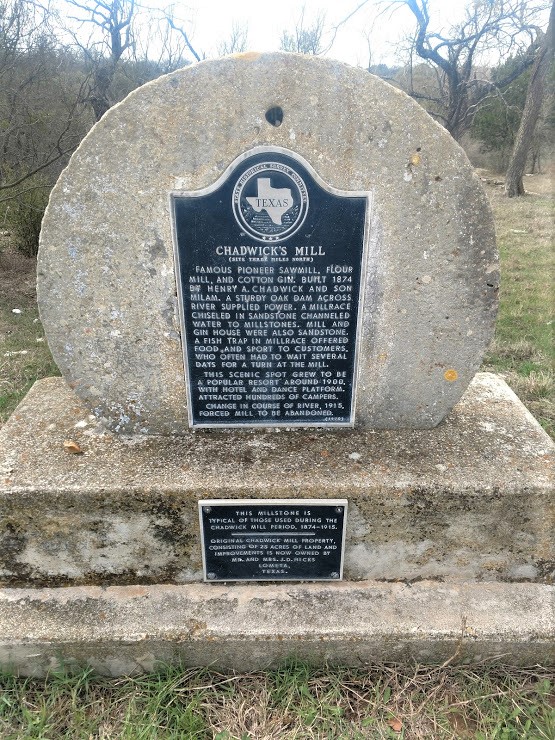
Rocky Mount Mills (GC7D3B), the second oldest cotton mill in North Carolina, was built in 1818 on a 20-acre tract of land at the falls of the Tar River. The mills were operated initially by Joel Battle and two partners, but by 1825 Battle was the sole proprietor. When Joel Battle died in 1829, his son William took over the operation of the mills. Built from local granite, the facility was three stories plus a basement; within the building, the Battles operated both cotton and grist mills.

A large industrial complex, Rocky Mount Mills was raided by Brigadier General Edward E. Potter’s Union cavalry on July 20, 1863. The mills, outbuildings, cotton, and yarn were destroyed by fire. William Battle rebuilt Rocky Mount Mills on the original foundation between 1866 and 1867. The new brick building, four stories with a basement, burned in 1869. Battle again rebuilt the mills. During the height of its nineteenth century production, the cotton mills, with about 50 employees, could process about 700 pounds of raw cotton per day.

In 1883 financial difficulties led William Battle to relinquish control of the mill. Thomas A. Battle, great-grandson of Joel Battle, was secretary to the mill’s new board of trustees. He eventually became president and the mills thrived under his leadership. Battle constructed additional buildings in 1889 and 1894. When Rocky Mount Mills closed in 1996, it was believed to be the oldest operating cotton mill in the South. It now comprises a local historic district and has been redeveloped into residential, retail, dining, and office space.


Also on the 20 acres next to the mills is the Battle House (GC78k8M). Constructed in 1835 by Benjamin D. Battle, a son of Joel Battle. In 1863, when the Federal cavalry burned the mill, the officer in charge spared the home because he and the superintendent of the mill were both Masons.

A village of small homes were built around the mills for those families working in the mills. In 1918 this village community house was constructed. It is now a gastropub.


Heading north up into Halifax County, I stop for a quick roadside geocache and get a good laugh also. The "Little Green Men" cache (GC4J08N) turned a simple cache find into a little bit of fun.


Driving the rural backroads around the country, I often stumble upon unexpected pieces of history. Passing through the community of Centerville, NC in Franklin County, I saw this old church building and had to stop. Centerville was established in 1882. This abandoned building was once the Serepta (sometimes spelled Sarepta) Methodist Church. In my research, I couldn't find any history on the church. However the nearby church graveyard has 33 interments which date back to 1879, a 35-year old Confederate Col John Preston Leonard. The towns charter was officially dissolved in 2017 due to lack of growth and population of less than 100. If you know anything more about this church, please send me a message.


Moving right along picking up some more quick roadside geocaches in the new counties of Franklin County (GC1QA2W) and Vance County (GC1KBYM). Then over in Granville County right off I-85 was a Travel Bug Hotel cache (GC1C8A2). It gave parking coordinates at the gas station next door, then a short hike over to trailhead, and then to cache. I arrived at the gas station to see a sign that said "Customer Parking Only." So I drive over to the trailhead. Didn't see any signs that said hiking or Jeeping. Looked like a GeoJeep trail to me. I was able to drive right up to within 50 feet of the cache.

On the way to my next county cache and again driving the backroads, I pass by this old house. With the modern appliance and power lines, does somebody live here or is it abandoned? Too bad I can't go exploring.


Speaking of exploring abandoned places... that brings me to my next geocache. Over in Person County is the Castle Mont Rouge (GC6H90P). An abandoned castle located 3/4 of a mile from this cache at the end of Mountain Brook Road. This Castle was designed and built in 2005 by American Architect Robert Mihaley. Abandoned in 2008, rumored because of the death of his wife. Some time after 2009 it was significantly vandalized in and out which allowed the elements to work on the interior structure. Because of the vandals, now there's a gate, fence, and no trespassing signs. So now you can't even drive up to see the castle.

Just a few miles away across the line into Durham County, is my next stop at the Blalock-Chambers Families Cemetery (GC6K69Y). This cemetery dates back to Justin Ruffin Blalock in June 1860. There are nearly 200 interments here in total. And they are "Never Alone."


Another few miles away in Orange County was another quick roadside cache (GC6K6BA). Staying on Hwy 57 south towards my next geocache, I encountered another of those surprise roadside attractions. Two life-sized horse sculptures, one made of scrap metal and the other of wood.


Making my way into Chapel Hill, I stopped at Battle Park to go hiking in the woods for the North Carolina Challenge Cache (GC19YRC). While I haven't yet completed all 100 counties yet, I can still sign the log as a "Write Note" for when I do find a geocache in each county. Hopefully by the end of this 3-day weekend.

I'm driving around trying to find a close parking spot to the cache but it's all residential with no public access to the park. So I turn around back to the west end where I remember passing by a few parking spots along the road at the edge of the park. But now instead of a 200 feet hike, it's closer to a quarter mile hike. I grab the hiking stick, more for poking in the ground and leaves listening to that "thump" sound of hitting the cache container, and a bottle of water and begin my journey.

On the plus side of parking where I did, my hike starts me off into this outdoor theater. The Forest Theater at UNC staged its first drama in 1916 to celebrate the 300th anniversary of William Shakespeare's death. William C. Coker, botany professor and founder of the Coker Arboretum, chose this particular location. A few years later, Professor Frederick Koch, founder of the Carolina Playmakers, developed the location into a permanent theater. Forest Theatre was rebuilt with Work Projects Administration funds in 1940 and was further improved in 1948. After taking a few photos, I headed for the woods.


It was a nice little jaunt hiking the Battle Branch Trail through the green forest. Once inside, it's hard to believe you're in the middle of town with houses and office buildings all around you. Even had a raccoon quickly scurrying along about 100 feet away. Tried to get a pic but it was too fast moving through the brush, trees along a creek. All I got were blurred photos with the phone. The one time I leave the Nikon in the GeoJeep.

I get to the geocache location and begin my search. I find the perfect hiding spot in this hollowed out fallen tree but no container. I expand my search looking all over but after 30 minutes there's nothing to be found. I even search further down the hill just in case it got removed by a critter and washed downhill. Nope no luck. The previous searcher just a week prior couldn't find it either. Well instead of a "Write Note," I'm gonna have to leave a DNF. Looks like I'm gonna have to make another trip back here.


On the way to my next geocache, I passed through the town of Cedar Grove, NC. In the mid-1700's, Scotch Irish, Germans, and English settlers migrated from the coastal regions to this back country area. The Cedar Grove Male Academy opened in 1845. By 1850 the towns businesses included a tanner, a coachmaker, a physician, a store and post office.

The Presbyterian Church erected in 1834 and renovated in 1901. Also built in 1834 was the Methodist Church. In 1939, a new Cedar Grove United Methodist Church was constructed and is the largest of the rural churches in Orange County built before World War II. After the Civil War, freed blacks began establishing their own communities and churches. In 1918, Lee's Chapel Baptist Church appeared at the outskirts of Cedar Grove, becoming the focal point of a small settlement of black farmers. 

The first of the photos I took was of the C.H. Pender Grocery Store. This two-story weatherboard building dates back to the 1880's. The one-story addition on the left side once housed a post office. It was moved across the road to its present location in 1900. Like the exterior, the inside still has its wooden shelving and glass display cases arranged along the side walls. The Allison Family first built the store back in the 1880's. The Oliver Family acquired the store in October 1907. Irene Oliver married C.H. Pender and they acquired the store in the 1960's.


Below is the Ellis Store built in 1923. This quarter-acre lot was first owned by Thomas C. Ellis who operated a store from 1871 until his death in 1892. In 1902 the lot and store were advertised for sale. At some point the store was acquired by W.J. Hughes from whom Thomas's son, Allen A. Ellis, purchased it in 1921. It was Allen Ellis that had this new building erected in 1923 and operated as a general store and post office. Allen Ellis retired in 1943 and his son Tom Ellis took over the business until he died in 1982. His widow Lucille eventually sold the property in 1995.


Heading north up into the town of McDade, I stopped for photos of this old abandoned gas station. This type of gas station and general store was built in the 1920's, a more modern and convenience version as the automobile became the mode of transportation replacing the horse and buggy. The front overhang protected the gas pumps. This store replaced an older 1880's store which was once across the street. Charles Samuel McDade owned and operated this store by 1940.


Moving along and driving north into Caswell County, I arrive at a virtual geocache called Rock City (GC9EF3). This miniature city, Shangri-La, began construction in 1968 by a retired tobacco farmer. For nine years this farmer built the tiny village out of rock removed from his farm land, concrete, and thousands of arrowheads. Among the miniature houses, the village includes a hotel, a mill, water tower, theater, a church, and more. There were 27 buildings in all. At the time of his death in 1977, he was working on adding a hospital to his village.


Moving right along, I stopped at a Bojangles in Yanceyville to grab a bite to each. While there I noticed a geocache in the parking lot (GC35H5Z) and of course I had to find it while I was there.

Going into Rockingham County, my next geocache was one of my favorites. A historical church with a graveyard. Wentworth Methodist Church (GC5NPD2) was organized in 1836, and the present sanctuary was constructed in 1859. It contains a slave gallery and is the last antebellum Methodist church building in Rockingham County. It was listed on the National Register of Historic Places in 1986.

Slaves and free blacks are buried in the cemetery behind the church, as well as members of the predominantly white congregation. Other officers and soldiers are interred here. Lt. E. Wheeler Hancock, who served in the Mexican War, became colonel of the 77th Regiment, North Carolina Senior Reserves, during the Civil War. Surgeon John R. Raine served in the 45th North Carolina Infantry. Lt. John P. Ellington, 72nd Regiment, North Carolina Junior Reserves, drowned near Fort Fisher. Capt. Berry J. Law, a native of England, served in the 69th Regiment, North Carolina Home Guard.

These obelisks mark the graves of George D. Boyd and three of his sons who died in Confederate service.  Capt John H. Boyd, Co I, 21st NC Infantry, died in Richmond, VA in 1861. Lt George F. Boyd, Co E, 45th NC Infantry, was killed in 1863 at the Battle of Gettysburg. Capt Samuel H Boyd, also of Co E, later was promoted to Colonel and was killed at the Battle of Spotsylvania Court House, VA in 1864. A fourth brother, Lt Col Andrew J Boyd of the 45th NC Infantry and later of the 22nd Battalion NC Home Guard, survived the war and settled in Reidsville, where he died and is buried.


Passing through the corner of Stokes County, I grab a quick parking lot LPC (GC61GYQ) at a Dollar General to claim that county. It's 8PM now and I've been going on fourteen hours. I decided to drive down into Forsyth County to find a hotel closer to my next cache in the morning. Along the way, another "roadside attraction" at a giant Bigfoot statue. Gotta get a selfie with this one. Can you see a resemblance? 


Well that's it for day #1 of my long weekend roadtrip. If I keep stopping for all these unexpected roadside attractions, I may not make all my planned county goals. But then that's a part of the journey and makes for a better backroads experience. Time to get some sleep. See you bright and early again tomorrow.

Thursday, December 12, 2019

2018-02-25: Geocaching Through Texas Cemeteries and History

Today's another Sunday which means another 360+ mile Sunday drive from Killeen to Monahans, Texas. Not a whole lot today. Just five geocaching finds and one hide. But some interesting history. So have a seat on this cool bench that I saw today and ride along with me.


My first geocache was called "Back At The Barnyard" (GC3FY0R). It was a quick roadside cache on a side street in Kempner. Going beyond that just up the road was the Kempner Cemetery. It didn't have a geocache hidden there, so I hid one myself: GC7JTPF. The town of Kempner moved a number of times during its early years of development. It was first settled in the early 1850’s, when a number of families named Pickett moved to the area, which became known as Pickett Valley. The community was also briefly known as Brummersville during 1865. Around 1854 Dan W. Taylor moved to the area with a large herd of cattle and built a store for his men on Taylor Creek, two miles from the present town site. A post office named Taylor’s Creek was established in his store in 1873.

The area was rowdy and lawless in its early days. There was considerable Indian trouble. Taylor asked Governor F.R. Lubbock for ammunition to help the settlers hold their own against the Comanche, but Lubbock wrote back that he and his neighbors should contact a man named Mr. Foster in Burnet for their gunpowder. As if that wasn’t bad enough, several stagecoach and mail robberies occurred between Taylor’s Creek and Belton. After Taylor’s death, the state sent Texas Rangers to the area. The crimes changed from Indian raids and stagecoach robberies to more common acts of the day: unlawful card playing, dogging hogs, maliciously killing dogs, disturbing the peace by using unbecoming or vulgar language in public places, such as the post office and churches, the unlawful carrying of pistols and fighting.

After Mr. Taylor’s death the community was named after a local landowner named Phillip Slaughter. The Taylor’s Creek post office was discontinued in 1878, and that same year a post office named Slaughtersville was established. In 1882 the Gulf, Colorado and Santa Fe Railway was built through the area, two miles from the Taylor store, and the community’s center finally became fixed when the post office was moved to a frame building near the railroad tracks and renamed Kempner after Harris Kempner, a Galveston merchant and director of the Gulf, Colorado and Santa Fe. The coming of the railroad caused the population to double. By 1884 Kempner had two steam gristmills and cotton gins, a church, a district school, and telegraph service, and by 1896 a hotel had been built. Telephone service was available by 1914.

The population of Kempner remained at an estimated 103 from 1904 to 1926. It rose briefly to 300 in 1927 but began to drop again in the 1930’s, reaching 125 in 1933 and remaining at that level for a number of years. It began to rise again in the mid-1960’s until it reached 420 in 1974, where it remained through 1990. Nine businesses were reported in 1986. By 2000 the population was 1,004 with fifty-four businesses.

The photo below is the grave site of George Waters who died January 26, 1882, at age 26. He was the first to be buried in the Kempner Cemetery.


Continuing west on US-190, I came to my next geocache and cemetery. "HPHR Senterfitt" (GC1E1FE) is where Reuben S Senterfitt came to this area near Lometa in the 1860's. A town named for him gradually built up and at its peak boasted hotels, mills, stores, saloons, a school, churches, a stage stop, and this cemetery. The town declined after it was bypassed by the railroad in the 1890's. The cemetery contains the graves of many early settlers. The oldest documented burial here is that of Joseph C Howell, who died in 1877 at the age of 3. Also interred here are veterans of the Civil War, World War I, World War II, and Vietnam.

When I saw this headstone in the cemetery, my first thought was "Who is John Galt?"


Before getting into San Saba, there's a bridge crossing the Colorado River. On the eastern edge you'll find my next geocache and a historical marker. Chadwick's Mill (GC17WEN) was a famous pioneer sawmill, flour mill, and cotton gin. Built 1874 by Henry A Chadwick and son Milam. A sturdy oak dam across the river supplied power. A millrace chiseled in sandstone channeled water to millstones. Mill and gin house were also sandstone. A fish trap in Millrace offered food and sport to customers who often had to wait several days for a turn at the mill.

This scenic spot grew to be a popular resort around 1900, with hotel and dance platform, attracted hundreds of campers. Change in course of river in 1915 forced mill to be abandoned.


Now on US-87 almost to San Angello, I stop for two geocaches near the town of Wall. The first cache was at the "Wall Cemetery" (GC18HA4). Wall, Texas, was originally called Lipan School, then Little School, then Murray's Store. The area was a school district covering 326 square miles, which was reduced to 237 square miles in 1889. The first settlers were J. C. and Lou Bell Bunnell in 1886. The town was named for J. M. Wall, a storekeeper who served as first postmaster; the post office opened in 1906. Wall served as the trading center for the fertile Lipan Flat region, where cotton and grain are grown. The town supports several businesses and a school. The population was 250 in 1920, 120 in 1930 and 1947, and 200 in 1980 through 2000.


About a mile or so to the south, is the entrance to what used to be an auxiliary air field for what was then "Goodfellow Field". Goodfellow Air Force Base now. In it's day, Goodfellow Field trained pilots and this was one of the major (paved) aux airfields used in the pilot training. The skies around San Angelo were full of buzzing little blue and yellow trainer aircraft. The planes were slow compared to what they have now. Later this became the entrance to the Wall Drag strip on the old runways. They raced cars here for fifty years. Now only the gates and a geocache are left (GCNRQB).

A quick stop for food and gas in San Angelo, then it was just driving the rest of the way. I hope you enjoyed my Sunday drive. Be sure to subscribe or Follow me using the buttons to the right. Or "Like Me" at the Away We Go Facebook Page! See y'all next Sunday...