Showing posts with label dinosaurs. Show all posts

Saturday, February 22, 2020

2018-05-05: Meeting Up With Friends From Florida To Go Geocaching and Exploring Waco Texas

Hello friends, adventurers, history lovers, and fellow geocachers! Welcome back to AwayWeGo's (that's us!) Geocaching Adventure Blog. I really appreciate all the likes and comments that we've been receiving on Facebook, Twitter, and here on this blog. Feel free to share our stories with your family and friends. Also, keep leaving your comments, suggestions, as well as a critique every now and then on how I can improve our blog.

OK, on to the fun stuff. I only worked 5 days this week so I arrived home in Killeen last night. That gave us a rare Saturday to go exploring together! WOHOO!! And doubly fun because we have a couple of our Florida geocaching friends staying nearby on their Spring/Summer RV tour. Well in reality, they're camping north of Dallas about 200 miles away. But for Texas that IS nearby! So we decided to meet up with the YankaBucs about halfway in Waco, Texas.


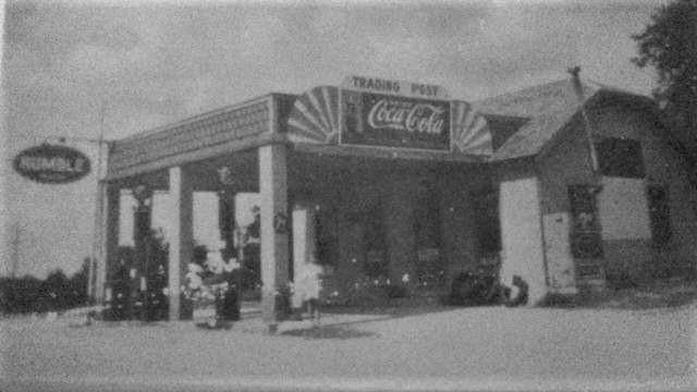
On the way to our rendezvous point, we passed by this old building. Since YankaBucs were a few minutes behind schedule, we decided to stop for a closer look and photos. A faded sign on the back side said "Water Works." Though it confused me about the train caboose coming out the side of the building.


Further research from a 2015 Waco Tribune-Herald Article, this 7,000 square foot brick building was built before 1902 as a pump station for the private Bell Water Company. They punched wells into the adjacent sands for Brazos alluvium groundwater. Acquired by city of Waco in 1904, it continued as a pump station even after the Riverside treatment plant was built in the late 1910s. Contractor F.M. Young acquired the property for his headquarters in the mid-1950s, then leased it to Geoffrey Michaels from 1975 to 1989 as the popular Water Works restaurant. A variety of less successful restaurants and nightclubs followed until disorderly crowds forced closing in 2009.


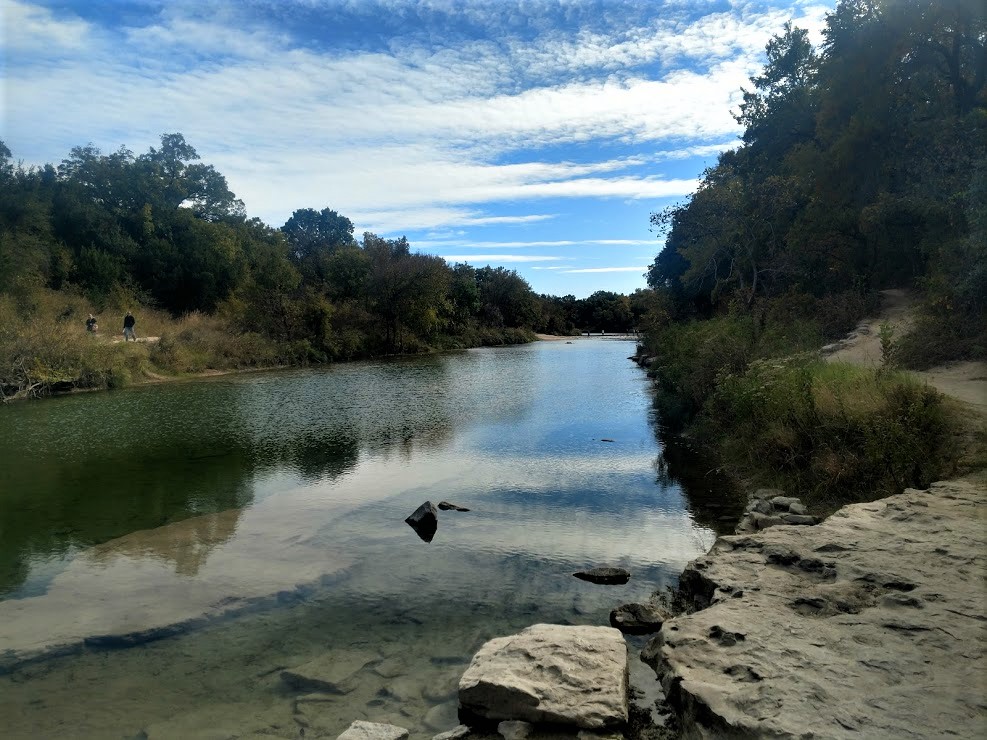
Continuing down the road a little ways, we met up with YankaBucs at the Waco Mammoth National Monument and our first geocache for the day. It was an Earthcache (GC5ZKCB). Waco Mammoth National Monument sits within 100 acres of wooded parkland along the Bosque River on the outskirts of town. Surrounded by oak, mesquite and cedar trees, the site offers an escape from the modern world and provides a glimpse into the lives and habitat of Columbian mammoths and other Ice Age animals.


On a spring day in 1978, Paul Barron and Eddie Bufkin embarked on a search for arrowheads and fossils near the Bosque River. To their surprise, the men stumbled upon a large bone eroding out of a ravine. Recognizing the unusual nature of the find, they removed the bone and took it to Baylor University's Strecker Museum (predecessor to the Mayborn Museum Complex) for examination. Museum staff identified the find as a femur bone from a Columbian mammoth. This now extinct species lived during the Pleistocene Epoch (more commonly known as the Ice Age) and inhabited North America from southern Canada to as far south as Costa Rica.

Strecker Museum staff quickly organized a team of volunteers and excavation began at the site. Using hand tools such as brushes and bamboo scrapers, crews slowly excavated a lost world. Between 1978 and 1990, the fossil remains of 16 Columbian mammoths were discovered. Their efforts uncovered a nursery herd that appears to have died together in a single natural event. Between 1990 and 1997, six additional mammoths were excavated, including a large male. Crews also uncovered the remains of a Western camel, dwarf antelope, American alligator, giant tortoise, and the tooth of a juvenile saber-toothed cat, which was found next to an unidentified animal.


Getting back into Waco, our next stop was at the Texas Ranger Hall of Fame and Museum. First opening in 1968 on the banks of the Brazos River, a smaller museum preserved the history and heritage of the Texas Rangers. The newer Hall of Fame displays many artifacts, exhibits, artwork and documents relating to this legendary group of law enforcement officers of Texas and the old west. There was even a whole room dedicated to the "Lone Ranger" fictional character full of TV and movie memorabilia, which Mr YankaBucs really appreciated.


Next to the museum is the historic First Street Cemetery dating back to Waco's founding in the 1850's. First Street Cemetery is the oldest public cemetery in Waco and is composed of three distinct cemeteries: City Cemetery, Odd Fellows Cemetery and Masonic Cemetery. In 1852, City Cemetery and Masonic Cemetery were officially established. It is not known when Odd Fellows Cemetery was officially established, but it was acquired by the City of Waco in 1866.

Now it really gets interesting when you combine the cemetery, the museum, and the Fort Fisher Park in the same area. It was discovered during the Hall of Fame expansion during the 2007-2010, that there were human remains underneath. It turns out that during the creation of the Fort Fisher Park and first Ranger museum in the late 1960's, as well as a "relocation" of graves to the larger Oakwood Cemetery to the south years earlier, that ONLY headstones were moved and not the remains of the bodies buried underneath. As you can imagine, that caused a LOT of community outrage and delays during the renovation and expansion plans!

As a surveyor myself, I had to include a photo of the Major George B Wrath statue there. Perhaps they could have used him to relocate the cemetery.


Now it is time for lunch. We saw this place across the highway also on the river called Buzzard Billy's. The decor and location were great and the food was excellent! However, I forgot to take any pictures. After filling up with a delicious lunch, we decided it was time for a walk along the river front to burn off some calories.

We crossed the Waco Suspension Bridge first. This was the Brazos River Crossing of the Chisholm Trail and a virtual geocache (GC2B5A). Imagine all the history that once crossed over this bridge.


In 1866 the Waco Bridge Company was granted a 25 year charter to build a toll bridge here. The charter guaranteed that no other bridge or ferry could be built within five miles. Construction began in 1868 and, after much financial difficulty, was finished in 1870. Bridge traffic included wagons, pedestrians, and cattle herds. Special rates were given to heavy users. From 1875 to 1889 the public agitated for a free bridge, but the company retained its monopoly. Then, in 1889, the bridge was sold to McLennan County which gave it to the city of Waco as a free bridge.


We continued strolling along the riverwalk finding various geocaches along the way and enjoying the day. (GC7ETPC, GC7ETQF, GC7ETQ9, GC7ETPY, GC6D2E, GC7C2NN, GC7C2N7) One of them had this monument. The inscription read: "Shakespeare! Daign to lend thy face, This romantic nook to grace, Where untaught Nature sports alone, Since thou and Nature are but one…1616-1916."


An easily overlooked memorial that pays tribute to William Shakespeare (1564-1616). How and why is it there? In 1916, on the 300th anniversary of his death, the Waco Shakespeare Club had it constructed and designed by Paul G. Silber, Sr. According to the Waco Shakespeare Club record’s at The Texas Collection, Baylor University, the organization began in the late 1890's at the Waco home of Kate Harrison Friend and her mother, Arimenta Harrison Friend, “conducting a private school guaranteeing their pupils thoroughness for higher grades.” Here, Kate Friend “…organized a class in the study of Shakespeare for the single young ladies of the elite of Waco. Here so much profit and enjoyment was experienced, that on request, a class for young matrons was formed.” Thus officially forming the club in 1899.


After making it around the riverwalk, we drove a few blocks over to the Dr Pepper Museum (GC2ATKV). Dr Pepper is a “native Texan,” originating at Morrison’s Old Corner Drug Store. It is the oldest of the major brand soft drinks in America. Like its flavor, the origin of Dr Pepper is out-of-the-ordinary. Charles Alderton, a young pharmacist working at Morrison’s store, is believed to be the inventor of the now famous drink. Alderton spent most of his time mixing up medicine for the people of Waco, but in his spare time he liked to serve carbonated drinks at the soda fountain. He liked the way the drug store smelled, with all of the fruit syrup flavor smells mixing together in the air. He decided to create a drink that tasted like that smell. He kept a journal, and after numerous experiments he finally hit upon a mixture of fruit syrups that he liked.


Dr Pepper gained such widespread consumer favor that other soda fountain operators in Waco began buying the syrup from Morrison and serving it. This soon presented a problem for Alderton and Morrison. They could no longer produce enough at their fountain to supply the demand. Robert S. Lazenby, a young beverage chemist, had also tasted the new drink and he, too, was impressed. Alderton, the inventor, was primarily interested in pharmacy work and had no designs on the drink. He suggested that Morrison and Lazenby develop it further. Morrison and Lazenby were impressed with the growth of Dr Pepper. In 1891, they formed a new firm, the Artesian Mfg. & Bottling Company, which later became Dr Pepper Company. Lazenby and his son-in-law, J.B. O’Hara moved the company from Waco to Dallas in 1923.


Around the corner from there was the Magnolia Market. Magnolia Market at the Silos, commonly called Magnolia Market, is a shopping complex that encompasses two city blocks in downtown Waco, Texas. It is marked by two 120’ high silos, built in 1950 as part of the Brazos Valley Cotton Oil Company. The grounds opened to the public in October, 2015.

The complex is owned by Chip and Joanna Gaines, TV personalities best known for HGTV's Fixer Upper TV series. The Silos, Waco, TX The grounds include a 12,000 sq. ft. retail store located in the historic grain barn and office building, a food truck park with picnic tables, a garden store, bakery, and lawn area. There was some kinda 5K event in the area today, so the place was just packed! This is the line below just for the bakery!


While the YankaBucs took a peak inside the Market, Candy and I stayed outside in the courtyard / lawn area because it was so crowded.

As we walked around the corner on our way to dinner, we passed by the First Baptist Church which I thought was worthy of a photo.


Then we arrived at Hecho En Waco Mexican Restaurant for another good meal. After an exhausting nut rewarding day, it was time to say our good-byes to our good friends the YankaBucs and head home. I hope you have enjoyed our tour of Waco, Texas. Until next time...

Monday, December 2, 2019

2018-01-14: Geocaching Through Cemeteries, Scenic Views, and Texas History

Before we get started, let me just say that I've created a Facebook page to help you stay up to date with my blog posts. So if you're on Facebook, be sure to like it so that you'll be notified when I post an update at: https://www.facebook.com/AwayWeGoUS

This morning we drove down from Killeen to Austin, Texas where I dropped off Candy again at the airport. This time she had a business trip to Philadelphia to train some directors up there. So just me and the GeoDogs for two weeks.


Making the drive back from Austin to Monahans, I head west on US-290 to just before Johnson City, Texas. My first stop was at Miller Creek Cemetery (GCRYZK) for my first geocache in Blanco County. From the historical marker: "Born in Tennessee in 1836, Thomas C. Felps came to Texas in 1856. He earned a living by freighting and joined the Blanco County Rangers during the Civil War. In 1863 he married Eliza V. White (b. 1846), a native of Ohio. In the summer of 1869, the couple lived with Eliza's parents while Thomas recovered from a fever. Her father, newly-appointed County Judge S. T. White, had gone to Blanco on July 21, 1869, when Thomas and Eliza were killed by a band of Indians on Cypress Creek. Only Eliza was scalped. The couples orphaned children, Thomas and Caroline, were cared for by Eliza's parents. (1975)"


Next I dropped south down to Bandera County and a very rural geocache along a lonely highway (GC79FB5). Before leaving the county, I made another stop in the Saint Stanislaus Catholic Cemetery (GC3NZ9P). The site, on a bend of the Medina River, had been occupied by Indians, then by white campers making shingles. The founders formed a partnership in 1853 to build a town and water powered lumber mill. The town and county were named for nearby Bandera Pass. Immigrant workers from Upper Silesia from the Polish colony in Karnes County were recruited. These workers arrived in 1855, and each family received purchase rights for a plot of land.

Population of settlers increased with the arrival of the cavalry at Camp Verde in 1856. After the Civil War the town boomed as a staging area for cattle drives up the Great Western Trail. Construction of a courthouse began in 1890. Looking through the dates on the cemetery, the oldest marked headstones go back to the 1860's. But there are many unknowns as well. The statue below is from one of the many graves.


Another cemetery further to the west and my next cache was the Vanderpool Cemetery (GC5EJYM). Originally called Bugscuffle, settlements began in the 1850's but disappeared in the 1860's because of Comanche Raids. Things began to pick up again and a post office opened for three years from 1886 - 1889. Re-opening in 1902, the name was changed to Vanderpool after the first postmaster L. B. Vanderpool. The town never really took off and the population stayed small over the years.


Just over the line into Real County was my next roadside cache called "A Million Miles" (GC2HWKM). I think I spent more time enjoying the views and taking pictures than it did finding the cache!


Slowly continuing westbound and still in Real County, I stopped by the Leaky Cemetery and another Geocache (GC6BV5R). This cemetery was originally known as the Floral Cemetery and served an earlier community by that name. The cemetery dates to at least 1881 when land for the cemetery was sold by John and Nancy Leakey for one dollar and a cemetery plot.

The oldest documented burials here are those of Sara Catherine McLaurin (b 1849) and fifteen-year old Allen Lease who were killed on April 19, 1881 in the last Indian raid in the Frio canyon area. There are over 900 documented burials here as well as a number of unmarked graves. Those interred in the Leakey Cemetery include pioneers, children, elected officials of Real and Edwards counties, community leader, and veterans. The founder of the town, John Leakey and hes wife Nancy are both buried here.

The next two photos were taken at the Leaky Cemetery. The first is one of the many statues. The second is the grave marker for Lucinda Smith Cope which I found to be an interesting story.


I say this often, but I love Geocaching because of the places it takes you that otherwise you'll never get to see. I mean if I wasn't Geocaching, driving from Austin to Monahans is only 375 miles and about 6 hours. Taking the backroads and siteseeing, I'm already at 4 hours and barely halfway. However, If I had taken the I-10 route, I wouldn't have discovered roadside attractions like these. This farmer / rancher takes their old equipment and sets it out in a field under a banner of "Rust N Peace" (GC3KNN5). The total size is probably 3-times the size as what you see in the photo and includes a few old trucks. But I wanted to get the sign in clearly for you to see.


Driving up Hwy 55, I get to my next quick county geocache called "On the way to Granch" (GC2F18G) for a find in Edwards County. And it gave me a nice photo:


Up in the NW part of the county at the intersection of Hwy 55 & Hwy 277 there's a roadside picnic area (GC1QP0N). Before the Interstate Rest Area/Plaza's with full facilities, many highways just had a safe pull off area with picnic tables. This one was slightly fancier with a round shallow pool and water fountain. Why have such a thing way out in the middle of nowhere? I guess for some cool relief during those hot Texas summers when not many cars had air conditioning. Though now it doesn't look like it has seen any water in a very long time except during a rain shower. Regrettably, I forgot to take any photos. But if you click on the GC# link, you can view the photo gallery there.

My last stop for the day was another one of these roadside picnic areas. But this time is was one of my own Geocache hides called "Because They ALL Should Have One - Dino Tracks" (GC6HYCZ). I've only hidden a couple of caches at these picnic areas and I give them the name "Because They ALL Should Have One" because I was once a truck driver. And I was also a Geocacher during that time. And I had to pass up a whole lot of caches because it's kinda hard to park a big truck pulling a 53' trailer at a roadside cemetery and many others. Of the caches I listed just in this blog, I could probably only have found just the previous picnic cache as a trucker. Maybe the "Million Miles" cache IF I already knew about the little pull off area in advance. More than likely though I would have just stuck to the Interstates.

At this particular picnic area there are also a couple of dinosaur tracks out behind it, so it makes for an even better reason to stop. This cache also went missing as indicated by previous cachers, so I stopped by to replace it. After a few photos of the road home after the sunset, I drive the last hour back to Monahans, Texas. That 375 mile, 6 hour drive turned into a 480 mile, 10 hour Geocaching Adventure. But I think it was worth it!


Thursday, June 13, 2019

2017-10-28: A Crumbling School, Cemetery, a Bridge, Dinosaurs, and Chocolate!

Welcome back and WOW what a day! Today we have everything from a crumbling school, to a cemetery, an old bridge, going way back to the days of dinosaurs, and finishing the day with decadent CHOCOLATE! So lets get started...

After finishing up work yesterday in West Texas, we made the long drive to Killeen last night. Today was a day for geocaching and exploring. After breakfast, we made our way up to Bosque County for our first cache and a new county. The Mosheim School (GC15B39) is a crumbling landmark of an era faded into the past. The town formerly known as Live Oak was settled in the 1850s with Jonathan Dansby given as an early (if not the first) settler.


A man named Jeff Howard built the first store in 1886 and submitted the name Mosheim for a post office which was granted the following year. In 1896 Mosheim had fifty people, a school, and several businesses. The population went from 171 in 1904, to 100 by 1925 and then reached its zenith in 1941 with 200 Mosheimers. It remained close to 200 until the late 1960s when it declined to 75. The town lost its post office in 1976.


The school was built in 1923 and by 1970 it had closed it's doors. Looking at various photos of the school online, the taller section above the entry along with the roof had collapsed sometime between 2013 and 2016. There's a really good article at the KWTX website talking to two locals who grew up and went to that school.

Just up the road is the town of Clifton, where we found our next two caches at the cemetery (GC6RW7N, GCT7BK). Clifton was founded in the winter of 1852–53, when the families of Samuel Locker, Monroe Locker, Frank Kell (whose grave and statue in the photo), and T. A. McSpadden settled in the vicinity. The town was named Cliff Town after the limestone cliffs that surround it. Over the years the name was altered to Clifton. The site was originally on the banks of Clear Branch. The Masonic hall and a log schoolhouse were the first public buildings. The post office was established in 1859. The First Presbyterian Church of Clifton was organized in 1861 and is the oldest church in continuous service in the county. The Baptists built the first church building in Clifton in 1884–85. After the Civil War J. Stinnett built a flour mill that was powered by the Bosque River. It was replaced in 1868 by a limestone mill, which was eventually converted to the electric power plant that provided the first electricity for Clifton homes. A three-story school known as Rock School was built around 1870 and served the community for more than twenty years. In 1893 a new building was constructed on property donated to the Clifton school system.


In 1880 the Gulf, Colorado and Santa Fe Railway built a station a mile south of Clifton. Merchants moved their businesses closer to the railroad station, and the town thrived as a business and trade center. The Merchant Exchange and Flour Mill, the first steam flour mill in the Bosque valley, was established in 1887 or 1888. The Clifton Record, a newspaper that began publishing in 1895 under the ownership of W. C. O'Brian, continued to serve the community through the years. Clifton also served as the county seat between 1890 and 1892. Clifton Lutheran College, later known as Clifton College, opened in 1896. The community was incorporated in 1901. An earlier attempt at incorporation in 1891 failed when the election results were declared invalid. A fire on December 23, 1906, destroyed a large portion of the business district, which was eventually rebuilt. The Clifton Volunteer Fire Department was organized in 1907. The town's need for a hospital was met by Dr. V. D. Goodall and Dr. S. L. Witcher in 1938. The Lutheran Sunset Home for the elderly was established in Clifton in 1954. The town had an estimated population of 204 in 1904 and 3,195 in 1990. It had 100 businesses in the 1980s. In the early 1990s an exotic-animal preserve open to tourists was located southwest of Clifton on Farm Road 3220. In 2000 the population was 3,542 with 262 businesses.

After leaving the cemetery, we headed to the north side of town to visit a piece of history before it becomes history. The Clifton Whipple Truss Bridge (GC6RW6C) was built in 1884. Still in use as one of only two bridges crossing the North Bosque River east of town. It had asphalt over the original wooden planks. But it's days are numbered. You can kinda see in the photograph, they're building a new modern bridge right next to it. And the word is when the new one is completed that the planks will be removed making it impassable. That's a shame. I like these old bridges. They should at least leave it for pedestrians, fishing, or just because.


Around the corner from the bridge was this rock structure. Wasn't sure what it was as there were no signs or anything. Perhaps a part of the old mill? So I began to Google for answers. Not even close to being an old mill. The City of Clifton offered the State of Texas 80 acres of land along the Bosque River for a state park. The state never accepted the donation, and the area remained a city park. Civilian Conservation Corps (CCC) Company 878 arrived in June 1933 to begin work on the park. The CCC built picnic and fireplace units, a semicircular seating area, entry portals, concession building and latrine all out of limestone. The CCC left their camp in Clifton in January 1934. This is what remains of the abandoned latrine!

Then there's this building on the corner. The sign says "First Chance," but I couldn't find any information on it. Then Bryan Davis from the BackRoads of Texas FB Group was able to help me out. He sent me this information: "My late friend Anna (Wood) Compton knew a lot of local history. Not sure many will recognize this photo from 80 years ago. This was a popular stopping point just before crossing the Bosque River on the west side of Clifton, where the old Whipple Truss Bridge stood. Anna lived here with her parents in the 1930s and her dad sold bait and tackle, picnic supplies, barbeque, cigarettes, and other goods. The Wood family lived in a back room partitioned with a sheet from public view. What fascinated Anna and me was that nothing appeared being done to preserve the limestone structure which was her childhood home. I've been told it is the oldest structure in present-day Clifton, pre-dating the move of Clifton to its present location with the arrival of the railroad about 1881. I recall Dan Orbeck and Ferman Grimm saying their families also owned the structure at various times. I'm sure there are issues with it being in a flooding zone, but I hope some measures are being taken to insure this landmark, which has survived some 150 years and numerous floods, receives proper preservation."

Thank you Bryan. I never thought the building would have been that old! Here's a picture Bryan sent me from back in the past:


From there we drove north on up into Somervell County and a town called Glen Rose. The town had a couple of statues around the courthouse square.


Also in the town square, is the tiny Hopewell Post Office and our last cache for the day (GC9B44). There are (or were) Hopewells in Franklin, Houston, Red River, Smith, Upshur and Williamson Counties. Somervell’s Hopewell is now covered by Squaw Creek Lake. Fortunately, great effort was taken to preserve a part of the forgotten community by moving its tiny post office to Glen Rose to sit on the courthouse square next to the museum. It's short history lasted from 1901 through 1904.


From there we drove over to the Dinosaur Valley State Park. In 1908, a flood of epic proportions roared down the Paluxy. It washed out all bridges and culverts on the river and scoured the riverbed. A year later, nine-year-old George Adams discovered something amazing in the river:  large, three-toed tracks - theropod tracks. Nearly 20 years later, a fossil collector for the American Museum of Natural History in New York named R. T. Bird saw one of the theropod tracks in a shop in New Mexico. He decided to come to Texas and check out the site. While exploring in the river, he was amazed to discover what looked like sauropod tracks, along with the theropod tracks. The tracks were the first proof that sauropods walked on land. The park opened in 1972 to preserve these valuable dinosaur track sites and to allow people to learn from and enjoy them. They also have some nice hiking trails along the river.


Getting late in the afternoon, and both starving by this point, we stopped in the town of Hico for dinner at the Jersey Lily's Mexican Restaurant. It was pretty good. The town is also known for this legend that supposedly Billy the Kid really wasn't shot and killed in his young life. But lived out a long life under an alias here in Hico. But what we REALLY liked best about this whole town was a visit to Wiseman House Chocolates! While at the restaurant I was looking up other things and town and saw this place. We just had to go visit after dinner. And it was a good thing we did!

They had this pure hot chocolate that was the best hot chocolate we've ever tasted. Something about taking pure melted chocolate, adding a tiny bit of water to keep it from hardening, and sipping it from a shot glass. So rich and delicious that's all you really need. The best chocolate I've ever had. We ended walking out with over $100 worth of several different types of chocolate, including this pure chocolate high healed shoe for Candy! I think it'll just be displayed in our kitchen forever. I can't see eating this shoe. Does chocolate go bad? Guess we'll never know.


Well that's the end of a wonderful day! I thank you for reading and following along in our adventures! Until next time...

Saturday, June 8, 2019

2017-08-19 Geocaching Route 66 in the Texas Panhandle

Welcome back to our Geocaching Adventures blog. Sorry for the delay in this post. Hopefully I'll be getting caught up with my writing soon.

On this weekend back in August, we had first made a stop in Lubbock, Texas for a visit to a cardiologist there. Afterwards we made our way up to Amarillo where we would stay for two nights while we Geocached and explored the Texas Panhandle. The goal was to go Geocaching in the ten remaining counties to finish the area.
County #1 Carson: While in Amarillo last year we had visited the famous Cadillac Ranch. This time  around we made a stop at our first cache and the lessor known Bug Ranch (GCDB98) on the east side of town. The Bug Ranch is the unsuccessful 2002 marketing idea of the Crutchfield Family for their Trading Post and Ranch. The five VW Beetles, closed trading post and motel are now just a place for tourists to get a photo opp and leave their spray painted signature behind. So I've seen the Cadillac Ranch, the Airstream Ranch down in Florida, and now the Bug Ranch. Are there any more?

Continuing eastbound on I-40/US-66, our next stop was a two-fer virtual (GC8B0E) and a traditional (GC68M62) cache in Groom, TX. As a former trucker, I had passed by this 190 foot tall cross and a couple of others like it throughout the country. 
If the huge cross wasn't enough, there are 12 prayer stations with 12 life-sized statues depicting various stages of Jesus' life. And further off to one side are more life-sized statues of the Lord's supper, 
Golgotha and the three crosses, and a cave representing the empty tomb. And finally a visitors center and gift shop.

What was supposed to be a quick stop, a few photos and go, turned into over an hour of looking, reflecting, and browsing the store. If you're ever driving down the highway and come upon one of the amazing crosses around the country, be sure to take the time and stop.

County #2 Wheeler: Getting back on track and two counties over, we stopped in Lela, TX to travel back in time a little. Originally called Story when it was established in 1902, a postmaster changed it the following year to Lela in honor of his wife's sister. By 1906 a nearby town became the center of trade and attention drawing residents and businesses away from Lela. The post office closed in 1976 and the school in 1992. The town's population has only grown from 50 in the 1940's to just over a hundred today. But it does contain two Geocaches: at the Old Lela Cemetery (GC61X3E) and the old red brick schoolhouse (GC2XZ1P).


County #3 Collingsworth: We then headed south on FM 1547 into a new county and another ghost town. Near the Salt Fork of the Red River in northwestern Collingsworth County. The town of Dozier was on the Rocking Chair Ranch until the ranch ceased to exist. Post office was granted in 1904 with the Dozier school district being organized five years later when a schoolhouse was built. The school's location changed several times until a larger building was constructed in 1913. This school lasted until 1929, when a brick school was built. By 1930 the population of Dozier was 60 and it somehow increased during the Great Depression to 100 by 1940. There's a historical marker there (GC245QN) but the school building itself has recently collapsed. As for the cemetery, it is still in use to this day and has over 400 permanent residents.


Over to US-83 and turning back to the north, I make a quick stop for an easy guard rail cache (GC21677). Back into Wheeler County and the town of Shamrock at the intersections of US-83, US-66, and I-40. Shamrock is the nearby town that boomed taking away from Lela that I mentioned earlier. The first cache I stopped for there brought us to a huge mural on the side of a building. Crossroads of Highways (GC2167E) highlights the towns history.


Another in the town of Shamrock is the Get Your Kicks! cache (GC1Q175). Going back to the famous Route 66 days, the Tower Station and U-Drop Inn's unique design and architecture were the inspiration for the body shop owned by the character Ramone in the animated movie "Cars."


There were two more caches in the NW corner of Wheeler County that I couldn't pass up. The first was at the Mobeetie Cemetery and called Wild West: Miss Mollie's Love (GC5EPXK). Mobeetie Cemetery is the first known established cemetery in the Texas Panhandle. It was born of necessity, established as a final resting place for those whose journey ended in Mobeetie, which evolved from an 1875 hunters camp and nearby army post. Over the course of time, some of the grave markers have been destroyed by both tornadoes and natural decay. The oldest gravestone is dated May 2, 1882. Other burials include outlaws, accused horse thieves, those killed by a 1898 tornado, ladies of the evening and the infant daughter of Temple Lea Houston. In addition it is the final resting place for the famed Texas Ranger Captain G.W. Arrington.

The cache is named for Miss Mollie Brennan. Her original marker has since long been destroyed or decayed, a memorial headstone is placed in the vicinity. It reads: Killed January 24, 1876, in a gunfight in Mobeetie, she was a young blue eyed, black haired beauty Lady Gay Saloon girl. She jumped in front of Bat Masterson and saved his life in the fight between Bat and Corporal Melvin A. King of Fort Elliot. This fight is where Bat received his leg wound and started using his famous cane. (Mobeetie was then Sweetwater City.) She was about the first one buried in this cemetery somewhere near this marker.

The other cache is at the Mobeetie Jail Museum (GC2GYFX). Mobeetie was as rank a place as any fancier of rankness could ever want. Gamblers, prostitutes and gunfighters turned Mobeetie from Hidetown into a frontier Sodom and Gomorra. Pioneer Panhandle cattleman Charles Goodnight described the town as "patronized by outlaws, thieves, cut-throats and buffalo hunters, with a large percentage of prostitutes."Temple Lea HoustonSam Houston's youngest son, wrote his wife that Mobeetie was "a baldheaded whiskey town with few virtuous women."

If you enjoy history as much as I and are intrigued by the previous paragraph, I encourage you to read more about Mobeetie's history following these links: Texas Escapes, a Bald-Headed Whisky Town, and Judge vs Marshal.


County #4 Roberts: Gotta keep moving along and up to Miami, TX in Roberts County for our next trio of geocaches. First was the Emerson No. 1 cache (GC3GQ1H) at the Miami Railroad Depot and Roberts County Museum. Miami supposedly derives its name from an Indian word meaning "sweetheart." The first settler on this site was Marion Armstrong, who in 1879 erected a half-dugout stagecoach stand near Red Deer Creek on the mail route from Mobeetie and Fort Elliott to Las Vegas, New Mexico. The town was platted in 1887 by B. H. Eldridge on the proposed route of the Southern Kansas (later Panhandle and Santa Fe) Railway. Samuel Edge and Mark Huselby purchased several lots and formed the Miami Townsite Company. Supplies for the railroad-construction crews were furnished by daily stages from Mobeetie. By 1888 Miami had 250 inhabitants and three hotels, three grocery stores, two saloons and a cafe, two livery stables, a post office, a mercantile store, a drugstore, and a tin shop. When Roberts County was organized in January 1889, Miami was chosen as county seat. The election, however, was declared fraudulent in December, and Parnell, twenty-five miles northwest, was the legal seat of county government until Miami won another election in November 1898. The present courthouse was built in 1913 to replace an earlier wooden structure.

The next two caches in Miami are located at the cemetery (GC5R93X, GC5R93C). The earliest cemetery in the town of Miami was established shortly after 1887 when the Southern Kansas Branch of the Atchison, Topeka and Santa Fe Railroad was extended through Miami. The earliest known burial is that of early pioneer William T. Lard who died on December 6, 1888 and was reinterred here prior to 1900.


County #5 Hemphill: Continuing up US-60 across the line into Hemphill County for a quick roadside cache. In the Shadow of the Giants (GCJZ0E) takes you to an area surrounded by oil wells with a huge dinosaur looking over them from the top of the hill. Because dinosaurs make the oil deep down in their underground factory right?


A few miles up the road stopping at the cemetery in Canadian, TX for the Hammer & Anvil cache (GC69PMF). After a bit of searching, we came up empty handed and had to log a DNF.

County #6 Lipscomb: Ugh, too much sightseeing and gotta make up time. Fortunately the next cache (GC117XQ) is a quick roadside stop cutting across the SW corner of Lipscomb County.

County #7 Ochiltree: Yay! Next over into Ochiltree County and another quick Cache and Dash (GC500DK) geocache at a picnic area.

County #8 Hansford: Now heading westbound on TX-15, we arrived at the Hansford County Cemetery (GC6BJJW) for our next geocache. It's the first burial ground set aside in this county. The earliest grave was that of Mrs Alfie P. McGee who died in 1890. Also buried here are the Cator Brothers, founders of Zulu Stockade, and the Wright Brothers, not the flyers but early ranchers. It was the only official cemetery in the county until 1928 and is still in use today. We didn't take time to look around though. Just grabbed the cache and drove on.

Getting late and running out of time, we turn south on TX-136 heading back to the hotel in Amarillo. The final two of the ten counties I needed will have to wait another day.

On the way back I still stopped for two more cemetery caches. I already had those counties so they won't count. Land for the establishment of Lieb Cemetery (GC5P1RG) was donated by Will Blakey and W.O. Jarvis in the spring of 1902. A meeting was held for the purpose of building a schoolhouse. Plans were made and lumber was hauled by wagon from Channing. Completion of the school was in April 1903. A two month school term was held that spring. Classes were held at Lieb until 1929, when the district was consolidated with two new districts, Pringle and Morse. The school building mentioned on the marker is now a community building for meetings of farmers in the area and sets adjacent to the cemetery.

That last one for the day was the Unknown Cemetery (GC5EPY6) located out in the farm land. There were just a few headstones of which only one could be barely legible. The headstone reads: N W Reeder 1827 1896. Neither the previous cache owner nor the current cache owner could find any information on the pioneer cemetery. And I checked the Findagrave website with the name listed above and came up empty as well. You can see from the photo below that if you didn't already know there was a cemetery there you wouldn't realize it.


So after a long day of caching and driving over 400 miles around the Texas panhandle, we made it back to the hotel in Amarillo with 20 caches and 8 new counties. Tomorrow we head back home down to West Texas.