Showing posts with label cowboy. Show all posts

Saturday, December 26, 2020

Discovering the Ghost Town of Oakville Texas and Researching Its History

Hello Friends, Travelers, and Geocachers. Welcome to another day in our AwayWeGo's Geocaching Adventures. Today I want to invite you along this roadtrip as I stop to explore a South Texas ghost town called Oakville.

It started out as my usual 360+ mile Sunday drive from Killeen, Texas down to Roma in the Rio Grande Valley. I was driving down I-37 and exited off the highway to get two geocaches in the Oakville Cemetery (GC2KPBH, GC78PKP) on the west side of the Interstate. From the historical marker at the Oakville Cemetery: "Donated in 1857 by Thomas Wilson, who also gave land for Main Town Square. The property was originally part of the 1831 McMullen McGloin land grant from Mexico. Among graves are those of J.T. James, the founder of Oakville; early pioneers; and organizers of Live Oak County."

As I was driving up the onramp heading south, I noticed out the corner of my eye across the east side of the highway all the old buildings of the town. That really sparked my interest so I continued driving down the Interstate six miles to the next exit. Then got off and made a u-turn another six miles back to Oakville.


Arriving in the Coastal Bend of Texas in the early 1800’s, Irish immigrants became the first settlers of a region that includes what is now known as the town of Oakville. At that time the community was referred to as "on the Sulphur" because it was on Sulphur Creek. It was also called Puenta de la Piedra ("Rock Bridge") by Spanish gold seekers, because two miles east on the Nueces River the San Antonio-Brownsville road crossed a natural rock bridge. After the Texas Revolution, Oakville was a station on the stage line from San Antonio to Corpus Christi. It had become a bustling place of commerce because it was the crossroads of ox-cart caravans and mule trains that crawled the muddy roads of Texas between the coast of the Gulf of Mexico and Brownsville to San Antonio. Oakville was the half-way point and merchants & travelers used it as a rest stop on such long, hazardous journeys of the day.

Oakville became county seat after Thomas Wilson offered 640 acres for a townsite; residents accepted the location on September 8, 1856. The name was taken by the court from a newspaper advertisement of business lots. Oakville had the county's first post office, established in 1857, and the first courthouse was built. The Oakville Baptist Church, constructed in 1856, had 128 members by 1857.


During the Civil War and for some years afterwards, Oakville and the surrounding region became a "hotbed of lawlessness." Looking through old newspapers, I found this article from the "Austin Weekly Statesman" October 5, 1876: "The state of society about Oakville, a frontier village, has been simply terrible. The people are divided into two classes; one, permanent, cattle-growing farmers; the other, horse and cattle thieves. They have shot and killed one another until honest men feared to tell the truth, and to punish red-handed villainy was impossible."

Historian Walter Prescott Webb described Oakville as "a hard country where civil authorities were helpless and took no notice of any outrage." As the county seat, Oakville grew into a thriving town that shipped cattle, horses, cotton, and wool, with a dozen or more stores, two hotels, a livery stable, a steam gristmill and cotton gin, a school, and two churches. However, with this boom of activity, the thought of the Wild Wild West that TV shows and movies were made of come to mind.

Growing to over 400 in population, there were 7 saloons in Oakville to provide the cattle crews plenty to drink and entertainment. Many stories of drunken cowboys, a lot of liquor flowed and many thrown in jail to sober up. Some of this spilled over into frontier violence in the form of horse thievery, cattle rustling and murder.

It took Texas Ranger Captain McNelley to clean up the lawless element in the 1870's. The Texas Rangers cleared out the outlaws in the region and brought them to the Live Oak County Jail in the county seat of Oakville, for justice. The standing historic jail was the third jail used in Oakville, the first two proving inadequate. The first one was a mud structure and the second of wood; both of one story construction. It was decided that something had to be done - for one, angry citizens could shoot the prisoners dead thru the jail bars in the absence of the Sheriff whilst he was away handling business.


The stone jail became a source of community pride. It was the latest design, the state-of-the-art in incarceration at the time of its construction. At two stories tall, it provided for safe lock-up in the upstairs cells until the judge arrived and provided formal offices for the Sheriff downstairs in which to conduct business. It also allowed for the sheriff's or jailer's family to reside on the first floor should they elect to do so. This important building served as the county’s jail from 1887-1919. The jail was constructed of hard native 22” sandstone, rough-hewn blocks, hauled by ox-cart from a nearby quarry.

For the burgeoning community, a jail of this stature was literally an advertisement and enticement to incoming settlers that Oakville would be a success in that it promoted civility and safety for it’s residents. The "modern" stone Oakville Jail of the 1880’s symbolized the arrival of the law to Oakville and to frontier Texas where previously only the six-shooter, rifle and the Texas Rangers administered justice to the wild and woolly lawless. Many a badman came to lament the day he entered the Oakville Jail. It is told that over 40 men hanged in the notorious sprawling live oak “Hanging Tree” outside on the Town Square.

Law and order once again established, Oakville's location as the halfway point between San Antonio and the Gulf Coast continued to create a boom of activity and business. The county's first free school building was established in 1881, and in 1899 Oakville established the county's first independent school district. The Oakville First National Bank, opened in 1905 by Dudley Blair and Lee Hinton, was also the county's first. The population of Oakville reached 400 in 1885, fell to 320 in 1892, then rose to a maximum of 450 in 1914.


Oakville's demise came just as many a ghost towns did in the west.  About 10 miles to the south, George West had plotted and named a town after himself. He courted the San Antonio, Uvalde, and Gulf Railroad to lay their tracks through his town and succeeded in 1913. The residents of Oakville began relocating to George West. And in 1919, George West became the county seat when its founder offered $75,000 to build a new courthouse there. State highway maps of 1936 showed a cemetery, two churches, a school, and several businesses and residences at the site. In 1940 the community reported a population of 350. By the 1970's only the Baptist church, the post office, three service stations, and scattered dwellings remained.


The State of Texas designated the town of Oakville a historic landmark in 1936 and placed a granite marker there. In 2004, the Oakville Jail was placed on the National Register of Historic Places.

Since the 1970's when Albert and Mari Davila first spotted the two-story stone jailhouse rising up out of the surrounding live oak and cactus. Over the following years, every time they'd pass by on their way down to Padre Island, they would stop for another look and exploring what appeared to be an abandoned town square. They eventually fell in love with the jailhouse and wanted to turn it into their vacation retreat house. They found the owners and purchased the Oakville Jail along with the abandoned town square in 2005.

With no windows or doors, they discovered many critters now calling it home as well. It was a slow process clearing up and cleaning out, but in 2007 restoration of the jail was completed. Locals had been admiring the work and inquiries into renting the jailhouse for special events and overnight stays began coming in. One by one the Davila's have been restoring old structures and adding to their number of rooms to rent. You can find more information about the restoration and photos at their website oakvillejail.com.


So that's it for another edition of my blog. I really enjoy finding these once forgotten treasures like the Oakville, Texas ghost town and sharing them with you. I'm also glad to see that someone has taken an interest and begun to restore the town square into what a typical pioneer town square might have looked like back in the 1800's.


For some reason, the closing theme song of the Beverly Hillbilly's TV show is running through my head. Yeah I know it's got nothing to do with Texas. But I'll leave it with you as anyway, though slightly modified: 

"Well now it's time to say good bye to You and all your kin.
And I would like to thank you folks fer kindly droppin in.
You're all invited back next week to this blog of mine,
To have a heapin'helpin of these words that come to mind.

Geocaching it is. Explore a spell, Put the hiking boots on.
Y'all come back now, y'hear?"

Monday, November 21, 2016

2016-10-22: A Train Depot, an Old Fort, and Dinner With Other Geocachers!

Hello again and welcome back to another day in our Geocaching Adventures. Today we're heading down to San Angelo for a Geocaching Event hosted by a cacher named mommio. Though it started with brunch, we didn't make it in time for that. We grabbed a few caches on the way and then cached around San Angelo before meeting up with everyone at dinner. But I'm getting ahead of myself.

Our first stop of course was the Starbucks in Odessa. Then on to Midland taking the TX158 exit east over to US-87 south towards San Angelo.

Our first Geocache was at the Water Valley Cemetery (GC13P18). The small community of Water Valley, TX dates back to the mid-1800's. The oldest marked graves date to the 1890's, though there are more than a dozen unknown grave sites.


A few miles down the road there's a historical marker and our next cache (GC1XXZ6). In 1911, the Texas Legislature passed a law calling for the establishment of state institutions for the treatment of tuberculosis. Across the street from the historical marker was the first such establishment. Opening in 1912, the Anti-Tuberculosis Colony No. 1 began with facilities for 57 patients on a 330 acre tract of land. The tuberculosis nursing school was founded here in 1915, and by 1961 had graduated more than 500 nurses. It was renamed the State Sanatorium in 1919. Because of the advances in medicine, it eventually closed in 1971 after treating 50,000 adults and 5,000 children.

Not too far away is the small town of Carlsbad, TX. The town began in 1907 and soon began growing. But between a three year drought followed by the lengthy depression, the population declined. Our next Geocache (GC1XY0W) brought us to this old bank building, probably built in the early 1920's. It would be interesting to see this structure restored. The walls seemed pretty sound. The roof and interior have fallen apart. But to leave the look of the exterior, upgrade and modernize the interior and you'd have a cool looking house.

We finally made it to mommio's house and the other cachers have already scattered about town to do some local Geocaching. We found the rather LARGE geocache on the front porch (GC1F8K8) before moving on around town ourselves.

The next few caches were a couple of fun simple gadget caches. Pinball Wizard (GC217N6) was one that we've found several of before. Think like pulling the plunger on a pinball machine to get the ball (cache) to shoot out. That was followed by Puff the Magic Dragon (GC214PD) where you had to blow into a tube to get the cache to pop out the top. Three Blind Mice (GC6Q2Q5) was up next followed by Twist and Shout (GC33RDA).

From there we drove over to The Cowboy (GC4RW35). It was a statue honoring the hard working ranchers in West Texas. We never did find the cache. Turns out it was missing.


We also spotted these wonderful murals on the side of a building highlighting early public transportation in San Angelo.


I finally decided to go over to get the cache located at the San Angelo Visitors Bureau (GC101N0). I figured while there we could also find out some of the more interesting and historical places in town. There we picked up some information on the train depot and the old fort. Since the train depot was closest, we headed over there first.

Train service first arrived in San Angelo in 1888 by the Gulf & Colorado Railroad, which was soon after purchased by the Santa Fe Railroad. But in 1900, the Kansas City, Mexico, & Orient Railroad also built a line through San Angelo. The depot here is the KCM&O depot built in 1910 and serves today as the Railroad Museum.
With the two competing railroads, San Angelo became the most important sheep, goat, and cattle shipping station in the country. The Santa Fe Railroad Company bought the KCM&O in 1928 after the oil boom. But in the 1950's passenger rail service began to dry up with the construction of new roads and highways. And on June 20, 1965, the last train departed from the depot.

After touring the train depot and viewing all the displays, we drove over to Fort Concho. The center of a line of forts extending from the northeastern border of Texas to El Paso, Fort Concho was also the northern point of southern chain of forts extending to the Rio Grande. Established in 1867 (at the junction of the Butterfield Trail, Goodnight Trail, and the road to San Antonio) by 4th Calvary under Captain George G. Huntt to protect the frontier.

By March 1, 1870, the fort buildings were a commissary and quartermaster storehouse, hospital, five officers quarters, a magazine and two barracks; all built of sandstone. On June 20, 1889, the fort was abandoned and the property passed into private ownership.

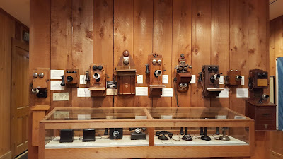
We toured through all the restored buildings and looked at the displays. One of the officers quarters was even made into a telephone museum where they had just about every type of phone ever made! There were also two caches there, well supposed to be two caches there. We found one (GC46FQX) but not the other (GCKX8T).


By now it was time to meet up with the group at the restaurant for dinner and talk of our Geocaching tales of the day. We had a good time meeting a lot of new cachers as well as seeing some familiar faces from other events.

There's a lot more to see around San Angelo, but as usual they'll have to wait another day. We just need to retire early! Until next time, see you back here or out on the caching trails.

Sunday, July 17, 2016

2016-07-02: Being Attacked by Alien Birds in Roswell, New Mexico

Hello and Welcome Back to AwayWeGo's Geocaching Adventure Blog. Today's adventure had us going up into New Mexico and was supposed to be deep into the earth at Carlsbad Caverns. However we forgot that it was a holiday weekend and it was very busy! So we decided to skip it for another day and continue up the road to Roswell, NM to see if we can find some extraterrestrials.

Our first Geocaching stop was near the town of Malaga at a New Mexico historical marker. (GC2AXZ6) The marker was to highlight the travels of Don Antonio de Espejo, leader of the third expedition to explore New Mexico, who passed near the spot on his return to Mexico City in 1583. After learning of the martyrdom of two Franciscan friars from an earlier expedition, he explored the Pueblo country and then followed the Pecos River Valley south.

Soon we arrived in the galactic rest stop of Roswell, NM only to find a packed downtown area due to the annual UFO Festival! Just not going to be our day. The line for the UFO Museum was out the door and down the block. I looked at the phone and found a nearby cache away from the activities that would also give us a moment to park and figure out what to do.

Arriving at our next Geocache (GC3A0KF) at the James Phelps White House. Built in 1912 and lived in by the family until 1972, the house was donated to the Historical Society of Southeast New Mexico in 1976. Now it is a museum.

Today the museum was closed, but we pulled in to find a car parked there with two ladies inside, probably in their 60's, and looking at us rather inquisitively. Were they also Geocaching? I parked about 5-6 spots away from them. After a minute or two, she pulled over closer about two spots away on my side. We stayed in our car and I just continued looking at my phone like I was texting. She then back out again and pulled up right next to us on Candy's side and rolled down her window. We then noticed she had cuts on her face and was bleeding. She proceeded to warn us about a bird that had swooped down and attacked them. This was the reason she had cuts on her face. We thanked her for the warning and they left.

Well being so close to the cache, I didn't want to leave without an attempt. The parking lot was about 100' from the cache location. We looked out the window but didn't see any bird flying around. I opened the door and looked some more. Nothing. A few SECONDS after standing up and looking around, this bird comes out of nowhere swooping down to about a foot above my head! I quickly jumped back into the car. There IS an alien attack bird out there on the loose! Now what to do?
Looking carefully we noticed a driveway running right along side the house and around back. So I pulled out from the parking lot and into the narrow driveway until I was just a few feet from the cache. Now we had some protection from the car, the house, and an overhang. I quickly jump out and spotted the cache. I brought it back to the car where I stamped the log sheet and placed it back. WOW! We've been on hikes with the threat of snakes, alligators, scorpions, and now Attack Birds from Outer Space! Let's get outta here!

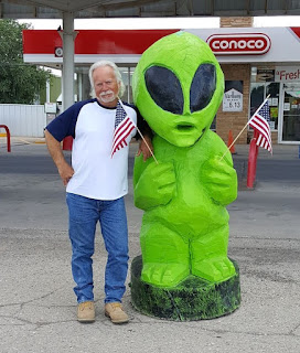
Back over to the main street through town where we managed to find a place to eat. A Mexican restaurant with slow service and just OK food. Nothing special but we were hungry. After lunch, we quickly strolled through the two blocks of festivities for a look. Mostly arts & craft booths with some alien stuff added to the mix. One of the most creative displays was this one guy who turned old tires into alien creatures, plants, and other objects. These were my distant relatives, the Goodyear family, from the planet Yokohama of the Uniroyalverse. On the drive out of town we stopped for gas and had my picture taken with a very patriotic visitor.


Heading south and back towards home, we stopped in the town of Artesia, NM. I noticed on the drive up a couple of statues along the roadside but didn't stop. But since Carlsbad and Roswell were packed full of tourists, I decided to stop here. The first one pictured below is called "El Vaquero" (the cowboy) and is firing a warning shot from his pistol into the air the warn the "Trail Boss" of the second photo that he has spotted some cattle rustlers coming their way.


The next two statues were also virtual Geocaches. The first virtual cache (GCGJGK) brought us to the First Lady of Artesia Sallie Chisum, a school teacher, reading a book to kids about outlaw Billy the Kid.


The next virtual cache (GCJC1X) commemorates the first oil well in Southeast New Mexico and the men who made it happen. The two men are John Gray and Mack Chase who were in the industry for many years. Below that is a statue that depicts the first oil well from 1924.


One last Geocaching stop (GC2CR17) for the day at a cemetery near Lakewood, NM. A small cemetery dating back to 1906. By now it was hot and we were wanting to get back, so we forgot to take some pictures.

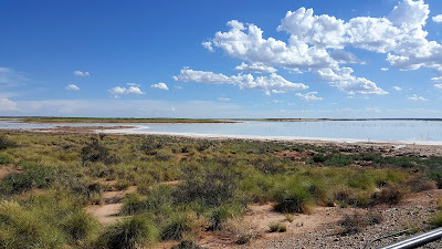
When we finally made it back down to Carlsbad, we decided to take a different route the rest of the way. We headed east along Jal Highway (128) and happened to pass by these lakes. They appeared to be salt water lakes and then noticed a sign for a salt mine. It's kinda hard to see from the photo and we didn't find any path to get down closer to the lake, but it looks as though that "white sand" around the edges was salt. There were also some parts that had tree stumps and other debris sticking up and they were all white and covered with salt also.


But that was our Geocaching Adventure for the day. Not what we had originally planned, but being spontaneous isn't bad either.

Thursday, March 3, 2016

2016-02-28: Geocaching Through History and Counties in North Texas

Hello again and welcome back to our Geocaching adventure blog. We hope you have been enjoying our travels so far. Today we set out to find caches in some new Texas counties. We're past the halfway point finishing the day with 133 of the 254 Texas counties.

Setting out from Lubbock after breakfast, we headed north on I-27. Our first stop was the Abernathy Cemetery in Hale County. A quick cache find here. The cache was located in some trees behind this headstone. Of all the cemeteries we've been in and the headstones looked at, I think this was the first with a Corvette on top. I'm sure this one cost a pretty penny too. However, after spending so much on this headstone, you would have thought they would have spelled "BELEIVE" correctly!


Continuing north on I-27 and a few more quick caches near an old grain silo, another at the Hale Center Cemetery, and follow by the Kress Cemetery.


Then, a couple miles to the northeast of the town of Kress and sitting out in the middle of farm land lies three very lonely graves. The Wright Cemetery cache page (GC5R9B1) doesn't give much history, but I was able to locate some info at Find A Grave showing 11 burials here. I only found 3 headstones. Looks like headstones have been run over by farm tractors throughout the years.


About a mile down the road from the cemetery looking across the farms and the flat plains, I saw a tiny black silhouette of an old truck and just had to investigate. And this is what we found sitting out on the corner of the dirt road and the end of the driveway to the farm house. It had seen better days and would make a great restoration project.


The next cache on our journey today was at Rose Hill Cemetery (GC31F7A). The history of this community cemetery dates back to October 1890. Just three months after Swisher County was organized and Tulia was named county seat. The first recorded burial here is that of 18 year old Louis Harral who died on October 17, 1890. His parents obtained permission from landowner T. W. Adams to bury their son on this hillside south of the Middle Tule Creek. Twelve days later, 4 year old Robert Alonzo Hutchinson died and was buried on the hill near Louis. In 1906 five acres of land surrounding the graves were officially set aside for a community cemetery.


Also in Tulia on display at the local VFW is our next cache (GC14K6N). This retired North American F-86 SabreJet.


Our next stop located in Briscoe County was built in 1894 of handcut stone hauled here by horse-drawn wagons from Tule Canyon. The Briscoe County Jail (GC2KVTG) stands as the lasting reminder of what courage and dedication mean in preserving law, order and integrity.

Early day sheriff's families rented the lower floor as a residence. It was also used by Red Cross workers for sewing during World War I. Near the old jail is the county courthouse and administration building.


Continuing east from Tulia over to the town of Silverton for our next cemetery cache (GC5N53J). I couldn't find much history about Silverton Cemetery, but while finding the cache I spotted these to headstones belonging to Robert S. Christian (23) and Warner S. Reid (24). They both died on the same day of October 23, 1895. After doing further research, I found newspaper article from from 1995 that had the story of these two. In summary, while moving a very large herd of cattle along with 75 other cowboys; lightning struck killing these two young men, both their horses, and ten cattle. You can see the full story from the newspaper link.


A couple more caches later and we're in the little town of Quitaque and our next  two caches (GC1RVHP). The first settler in the area was the Comanchero trader José Piedad Tafoya, who operated a trading post on the site from 1865 to 1867, trading dry goods and ammunition to the Comanches for rustled livestock. In 1877 George Baker drove a herd of about 2,000 cattle to the Quitaque area, where he headquartered the Lazy F Ranch. Charles Goodnight bought the Lazy F in 1880 and introduced the name Quitaque, which he believed was the Indian word for "end of the trail."

Residents used other area graveyards to bury the deceased until 1922 when brothers Alvin and Edgar Howard donated ten acres for cemetery use. The first person interred in RestHaven Cemetery (GC1QZJV) was Katie Daniel in 1922.

The next town down the road was originally called Turkey Creek, then Turkey Roost by the locals. Eventually it was shortened to just Turkey by the time the Turkey Hotel, now a Bed & Breakfast, opened its doors in 1927. There was supposed to be a cache hidden near the hotel (GC1X8B3), but  we couldn't find it and neither could the last few cachers. It looked as though there may have been some bushes there at one time. And the cache owner hasn't been active since 2010.


Turkey is also known for being the hometown of Bob Wills which is our next virtual cache (GCCDBD). James Robert "Bob" Wills (1905 – 1975) was an American Western swing musician, songwriter, and bandleader. Considered by music authorities as the co-founder of Western swing, he was universally known as the King of Western Swing. Wills formed several bands and played radio stations around the South and West until he formed the Texas Playboys in 1934 with Wills on fiddle, Tommy Duncan on piano and vocals, rhythm guitarist June Whalin, tenor banjoist Johnnie Lee Wills, and Kermit Whalin, who played steel guitar and bass. The band played regularly on a Tulsa, Oklahoma radio station and added Leon McAuliffe on steel guitar, pianist Al Stricklin, drummer Smokey Dacus, and a horn section that expanded the band's sound. Wills favored jazz-like arrangements and the band found national popularity into the 1940s with such hits as "Steel Guitar Rag", "New San Antonio Rose", "Smoke On The Water", "Stars And Stripes On Iwo Jima", and "New Spanish Two Step".

Also in town is this old restored gas station and Bob Wills and the Playboys tour bus.


Moving on to our next county and next cache (GC62PGC). This area of Motley County was first called "White Flat" due to the tall white needlegrass which covered the flat prairie land. A post office, named Whiteflat, was established for the rural settlement in 1890 at the request of W. R. Tilson.

At its height, the community boasted four grocery stores, three service stations, three garages, two cafes, a hardware store, two gins, and three churches. A school first housed in a one room schoolhouse built by volunteers, opened in 1890. It was replaced by a four room school in 1908, and in 1922 a new two story brick structure was erected (see photo). It also served as a community gathering place.

Dependent on an economy based on agriculture and small family farms, the community began to decline during the depression and dust bowl years of the 1930's. The Whiteflat school closed in 1946 when it was consolidated with Matador schools. The local churches disbanded in the 1960's, the post office closed in 1966 following the death of the last postmaster, and the last remaining retail store closed in 1968. A few residence still exist, but it's pretty much a ghost town.

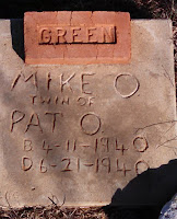
The Whiteflat Cemetery (GC2P34E) dates back to 1894. The hardest thing to see although quite common at that time, are headstones for babies and children. And here the Green family had three. And based on the headstones, they were probably of little means as well.


Our next cache in Motley County was Bob's Oil Well (GC17NTQ) and a piece of American roadside attractions. From the historical marker: "Greenville, Texas native Luther Bedford "Bob" Robertson (1894-1947), a veteran of WWI, came to Matador in the 1920's. He was a gas station attendant in 1932 when he decided to open a service station here. To promote his new business, he built a wooden oil derrick over the station. He patented his design, and in 1939 replaced the wooden derrick with one of steel that reached 84 feet in height and included lights.
Robertson was a gifted businessman and promoter, and he used any opportunity to advertise his operation and attract customers. He kept a cage of live rattlesnakes for the amusement of tourists, and from that initial attraction grew a zoo that included lions, monkeys, coyotes, a white buffalo and other animals. He paid long distance truckers to place advertising signs at strategic points across the nation noting the mileage to Bob's Oil Well in Matador, and they became well known to the motoring public. As a result of his success, Robertson enlarged his operation to include a grocery, cafe and garage.
Bob Robertson dies in 1947, and two weeks later a high wind toppled the steel derrick that had been the trademark of his business. His widow restored it two years later with even larger lights. The business did not continue long after, however, and closed in the 1950's. Later efforts to re-open it were short lived. Today, the site serves as a reminder of a time when such bold roadside architecture was in its infancy and of a man who, through his business, widely promoted his adopted hometown."


The Motley County Jail was next. Similar to the Briscoe County Jail above, this 2-story jail was erected in 1891, the year Motley County was organized. Cells were on the top floor of the structure and the jailer's living quarters on the lower level. The first courthouse, also built in 1891, later burned, but this jail remains as a symbol of Motley County's frontier heritage.


Our last cache to highlight was at the Cottle County Heritage Museum (GC13AA8). I liked the old ambulance and fire truck outside. 


It was a long day and I think we drove over 300 miles. But we learned a lot of history, saw some cool sites, and just had a great day driving through Texas.