Showing posts with label backroad. Show all posts

Friday, December 23, 2022

2021-03-27: Visiting the Birthplace of Ben Hur on Day 5 of Turning a 1400 Mile Road Trip into a 3404 Mile Adventure!

Today was a special geocaching roadtrip day. While I've never heard the name of General Lew Wallace before, I'm VERY familiar with his work. Or more specifically a 1959 interpretation of his work. In 1880 Lew Wallace's second book, "Ben-Hur: A Tale of the Christ", was published. Today we got to visit General Lew Wallace's Study and Library. So come aboard and join us on Day #5 of our 3404 mile road trip adventure. Today's journey has us finishing up Indiana and into Illinois. Are you in? Let's go for a drive...


We started out the day in Crawfordsville, Indiana in Montgomery County. The first stop was downtown for a virtual geocache (GCHXCT). The Montgomery County rotary jail and sheriff's residence was built in 1882. The first rotary jail built in the United States constructed based on plans based on patented design of William H. Brown and Benjamin F. Haugh of Indianapolis. Used as a jail until 1973 and opened as a museum and restoration begun in 1975. It was also listed in the National Register of Historic Places in 1975.

The circular cell block has sixteen wedge-shaped cells on a two-story turntable around a central shaft. The design promised better prisoner security and jailer safety. The cell block was immobilized in the 1930's as a hazard to prisoners. County jails were first established in 1792 under laws of Northwest Territory; continued under laws of Indiana Territory and state constitutions of 1816 and 1851.


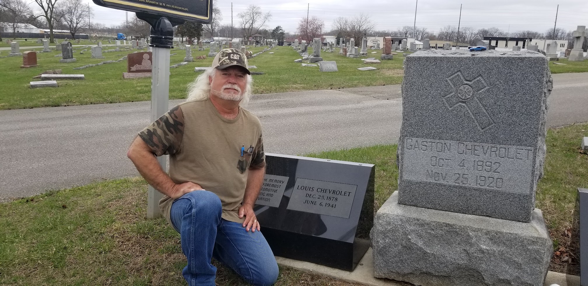
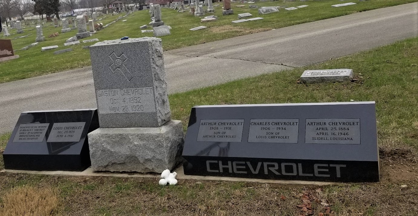
We then drove over to the homesite of Lew Wallace. It was still a little early and the grounds and museum wasn't open yet. So the next three geocaches were located just outside the northwest side of town in the Oak Hill Cemetery (GC2JHCJ, GCVTJ8, GC2GGZB). Formed on April 12, 1875, the Oak Hill Cemetery Company purchased 100 acres and the cemetery was dedicated on October 20th. Today the cemetery hosts over 14,000 interments.

Among the many notable permanent residents here, like Civil War officers, Congressmen, a Governor, and others, is General Lew Wallace and his wife Susan Arnold Wallace. This is the monument for the Wallace burials. Let me first tell you about Susan Wallace.

Susan Arnold Elston was born on Christmas Day in 1830. She was an accomplished author who wrote travel articles for several magazines and newspapers across the country. Susan married Lew Wallace in 1852. She also wrote six books that were published in her lifetime: "The Storied Sea" (1883), "Ginevra" (1887), "The Land of the Pueblos" (1888), "The Repose in Egypt" (1888), "Along the Bosphorus and Other Sketches" (1898), and "The City of the King" (1903). Before her death in 1907, Susan completed Lew Wallace's 2-volume autobiography which he started before his death in 1905.


Now back at the General Lew Wallace Study and Museum (GC1EQWB), these are the north grounds of the Wallace estate. Lew and Susan Wallace built their modest Victorian home on Elston Family land in 1868. The house was sold to outside the Wallace family in 1919. A brick wall was then built by Lew's son Henry to separate the two properties. The main house is still private property and not a part of the museum.

Upon entering the grounds, you'll first encounter the Carriage House which is now the museum office. The Wallace's built the carriage house by 1875. It contained a stall for Lew's horse, "Old John", a carriage room, a hay loft, and a workshop where Lew worked on his inventions. The house was first remodeled in 1946 and used by the girl scouts. The exterior was restored in 2006 retaining its Queen Ann elements from the 1800's. The interior was adapted to be used for the museum office, gift shop, exhibit room, kitchen and storage. The Wallace's original unrestored carriage (seen below) is located in the basement of the study.


Copied from the informative sign on the grounds: The Ben-Hur Beech Tree and Statue of Lew Wallace. "Its spreading branches droop to the ground... and under them I am shut in as by the walls of a towering green tent. How often while lending me its protection and fragrant coolness, it has been the sole witness of my struggle to whip an obstinate thought into comeliness of expression; and how often out of respect for me it has maintained a dignified silence when it might have laughed at my discomfiture." -- Lew Wallace, about his beloved tree.

Lew Wallace wrote much of his famous novel, Ben-Hur, under this huge tree which came to be known as the Ben-Hur Beech. Because he loved the outdoors, Lew often brought a favorite rocking chair and lap desk outside to work. The tree was struck by lightning in 1907 and taken down in 1908.

In 1910, the Indiana State Legislature honored Lew by placing a statue of him in Statuary Hall in Washington, D.C. Lew's son Henry was so impressed with sculptor Andrew O'Conner's work, that he ordered this bronze copy and placed it where the Ben-Hur Beech Tree once stood.


Now for the main attraction. In 1879, Lew had written to his wife Susan: "I want a study, a pleasure-house for my soul, where no one could hear me make speeches to myself, and play the violin at midnight if I chose. A detached room away from the world and its worries. A place for my old age to rest in and grow reminiscent, fighting the battles of youth over again."

Construction of his "pleasure-house," known today as the Lew Wallace Study, began in 1895. It was designed by Wallace himself and combines elements of the Greek, Roman, and Byzantine architecture that he saw in his travels. Lew Wallace enjoyed his refuge for the last ten years of his life.


Stepping inside the study was like stepping inside the mind of Lew Wallace. In his public life, Lew was a lawyer, a soldier, Union General during the Civil War, Governor of the New Mexico Territory, U.S. Ambassador to the Ottoman Empire, and author. As well as writing, he also enjoyed painting, fishing, music, reading, inventing, and the outdoors.

The first thing that caught my eye is what I was most interested in, the Ben-Hur display! The short sword was used in both the 1925 and 1959 movie. The wrist band was worn by Francis X. Bushman (Messala) in the 1925 movie. The album is a souvenir from the Broadway Play. The photo just to the left of the red Ben-Hur spice cans is of Charlton Heston while visiting the Lew Wallace Study in 1993.

The book is a "first edition, binding state 1" of Ben-Hur. This first edition was approximately 2,500 copies and featured a floral pattern on blue-gray cloth. Susan Wallace objected to the cover, so subsequent bindings of the first edition were brown mesh cloth (binding 2) and brown pebbled cloth (binding 3). While all these are considered first editions, the floral binding was the initial cover and the rarest. If you ever see one of those at a garage sale... BUY IT QUICKLY!!


Standing tall next to that display case was the complete suit, robe, sword and armor worn by Charlton Heston in the 1959 movie.


Lew Wallace had an extensive collection of books in his study. This is just a section of those shelves that practically wrapped around the entire room. Ben-Hur had been translated into more than twenty languages and there's a least one copy of each on the shelf. He also has a large selection of bibles and study guides. His portrait is at the top left in the photo below as well of the smaller photograph in the bottom right corner.


Not only did Lew own and play some of the finest violins of his day, but he also learned the craft of building his own violins as well.


Painting was another of his hobbies. Much of the artwork hanging in the study was painted by him. This was his watercolor set along with a small sketch and a finished painting.


Fishing and inventing were a couple more of his many interests. The silver piece at the bottom of the next photo combined both of those. An invention of his that spooled the fishing line inside the pole, not externally.


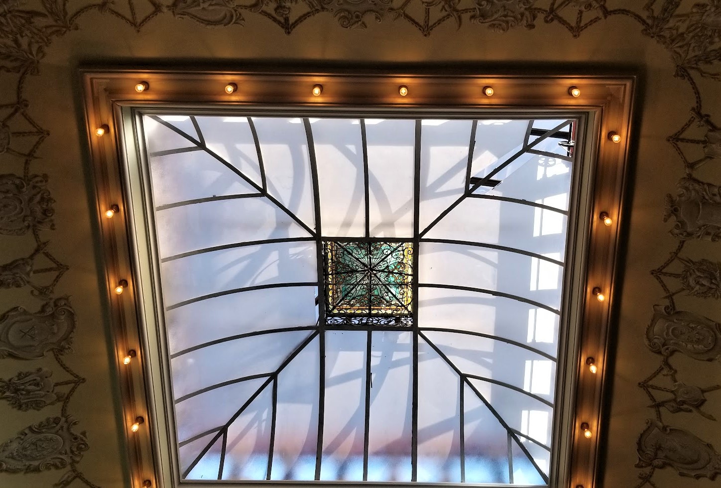
The last thing I want to show you is the large skylight in the center of the study. You can get a good look at it from the outside in the photo at the top of the page. This skylight actually has a crank on the corner which Lew Wallace used to open and close it allowing for a cool breeze to circulate on the warm summer days.


There is much more to be seen here at the General Lew Wallace Study and Museum. But I'll just leave that up to you to go and visit this historic place in Crawfordsville, Indiana, just northwest of Indianapolis. We spent a few hours here.

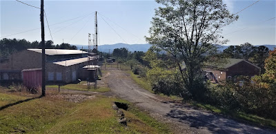
A great example of what I like about geocaching. Driving from point A to point B like I used to and I would have just passed these places all the time. Now because of geocaching, I look for the places to see and stop along the backroads.

A few more geocaches in Indiana to pick up Fountain, Warren, and Vermillion Counties before moving into Illinois. We did grab some geocaches in Illinois today also, but I decided to tell you about those in the next blog with the other Illinois caches. I wanted to focus on the Lew Wallace story in this one. So, see you back again real soon.

To follow along on our travels and keep up with my latest blogs, you may do so here of course by clicking the "Follow" button to the right. But also by using one or more of your favorite of these social media platforms: FacebookMeWeGabRedditParlorTwitterRVillageGETTRInstagram, and TruthSocial. These all link directly to my profiles. Again, please feel free to comment and / or share.

Friday, November 25, 2022

2021-03-26: Day 4 of Turning a 1400 Mile Road Trip into a 3404 Mile Adventure! From Ohio into Indiana.

So today was Day 4 of our adventurous road trip where we turned a simple 1400 mile drive from NC to TX into a 12 day 3404 mile sightseeing tour! On this fourth day we finished traveling through Ohio and into Indiana, continuing to pick up new geocaching counties and finding more remnants of the old National Road. So come ride along with us as I share our geocaching adventures with you.


Waking up in Columbus, Ohio this morning, our first stop was for some Starbucks coffee. Well, Candy got a Starbucks coffee. I got the geocache in the parking lot (GC25QYX). Then we drove a few blocks away to a Dunkin Donuts where I then got a coffee and donuts for myself as well as a muffin for Candy.

Continuing our westbound roadtrip and following the Historic National Road (now US-40), we pulled into the Sunset Cemetery in Franklin County for several geocaches hidden here (GC77D86, GC4QFG8, GC54E7E, GC4ER7X). All three geocaches had a lot of favorite points awarded to them so we just had to stop by and find them. A nice Veterans Memorial was on display. But Jack's Cache was by far the favorite and even posted both a photo and video of it below. Be sure to have your sound turned up when playing the video!


(Turn Sound ON With Video!)

One of the advantages of driving the backroads on a roadtrip are the unexpected gems that get to be discovered along the way! Passing through the small Village of Lafayette in Madison County, Ohio, what first got me to stop was spotting this tour of Jeep history somebody had displayed on this fence. It was a perfect photo opp for the Geo Jeep Travel Bug!


Then taking a closer look at the old buildings along this stretch of the historical highway. This first one here I can't find much information on it. The plaque above the front entrance says "Deer Creek Tp, Sub-Dist No 1, 1906." I'm thinking it was an early school that has long been closed. One of the rear buildings has B. S. A. on it and can only assume that at some time in its historical past that the Boy Scouts of America had rented the building. If any of you can provide further details, please use the comment box below. It would be greatly appreciated.


This other building across the street is on the National Register of Historical Places. From the historical marker: "The Red Brick Tavern is a classic roadside inn and tavern from the heyday of the National Road. Constructed between 1836 and 1837, it was in operation when the road was completed past its front door. Over the years, the Red Brick Tavern was a popular place for travelers along the Historic National Road in Ohio. The Tavern hosted six presidents of the United States; John Quincy Adams, Martin Van Buren, William Henry Harrison, John Tyler, Zachery Taylor, and Warren G. Harding."


Running north and south along the west side of Lafayette is Deer Creek. To claim a geocache in Madison County we went to the Deer Creek Cemetery (GC1ZDYX) which is next to the creek. While some of my favorite geocaches are cemetery caches, I was more interested in the geocache next to the cemetery.

Crossing the creek about a 1000 feet south of the current alignment of the National Road / US-40, spans the remnants of an early railroad bridge This Interurban bridge was part of the railway that was part of the Springfield London Columbus route. This railway was run by the Columbus London & Springfield Railway from 1902-1939. The Interurbans provided a quick and cheap alternative to regular railroad for transporting people. As for the geocache, well I couldn't find it. Along with many others. It has since been archived.


The next county over is Clark County. It's also where my next two geocaches are located (GCZEFX, GCRDQC). In 1841, Ezra Baker gave the township land to the northeast edge of Enon for a cemetery. Land was added to the Enon Cemetery in 1884, in 1906, and again in 1978. There are earlier burials than 1841, but these were moved from family plots. Three Revolutionary soldiers, two War of 1812 soldiers, many from the Civil War, plus soldiers of more recent wars, are buried in the cemetery. There is a Soldier’s Monument, bearing the names of 31 local men who died during the Civil War, but not necessarily brought home for burial.


Continuing westbound a few miles and dropping down into Greene County, we make a stop for a quick geocache in the corner of a parking lot to claim the county (GC104NY).

After Greene was Montgomery County and the next three geocaches. The first one was located at the Polk Grove Cemetery (GC3W2YG). The cemetery is located next to the Polk Grove United Church of Christ. Since I didn't have time to look around the cemetery, I'll just leave you with this little tidbit. What's the difference between a cemetery and a graveyard? A graveyard is what they used to call a cemetery located on church grounds.

The second geocache was another location along the historic National Road. Patty's Bridge (GC196PD), located in Englewood Metro Park, is named after the James Patty family who owned a 160-acre farm in Butler Township. The Patty's brick farmhouse, torn down in about 1975, was located on the high ground northeast of the bridge. The original stone abutments for the bridge are still in place and demonstrate the skill of the workman building the highway. The National Road was America's first interstate highway.


Thomas Jefferson was president when construction of the road began in 1807. It started in Cumberland, MD and reached this part of Ohio in about 1838. The original route of the National Road took it due west of Patty's Bridge and into Harrisburg (now Englewood) Ohio. After Englewood Dam was completed in 1922, the National Road (which later became U. S. Route 40) was rerouted to the south and over the dam. By 1840, the National Road was completed to Vandalia, IL and then later to St. Louis, MO. Today this road spans the entire United States from Cumberland, MD to San Francisco, CA.


We stopped for one more geocache in Montgomery County. It was for a tasty treat at the Esther Price Candies chocolate factory (GC44BKB). It was an expensive geocache. Yep, we bought about $60 worth of chocolates by the time we left!


Our final county geocache for Ohio was a quick roadside stop in Preble County (GC2PMGT).

Crossing over into Indiana, the first county is Wayne County. And for our next geocache we stopped at the Old National Road Welcome Center (GC1WJPK). The Indiana portion was built between 1829 and 1834, linking the eastern seashore with the western interior. The automobile revived The National Road in the 1920's. As cars and trucks took to the road, the federal government established a nationwide network of paved, all-weather highways.

The Old National Road was one of the first routes designated under the new federal highway numbering system in 1926, US Route 40, a transcontinental highway. Once again, the new road gave way to new opportunities. Like the blacksmith shops and taverns of the past, gas station, diners, and motels lead the way to a new era of prosperity. Until the 1970's, with the completion of Interstate 70, US-40 was one of the country's primary east-west routes.

Next door over in Henry County, my geocaching county stop was at the New Lisbon Cemetery (GC8RFP1). After finding the geocache, just a quick glance around and a photo before continuing down the road.


Wanting to make up time and get to Indianapolis before it gets too late, I hop onto Interstate 70. The next county is Hancock County. We stopped for a quick westbound rest area geocache (GCPTZV).

We finally pulled into Indianapolis and I head to the Indianapolis Speedway. But it was too late. The Speedway was closing. From there we drove to the south side of the city to the Holy Cross and St Joseph Cemetery. I was here once before way back in 2007. I was once an over-the-road truck driver. The trucking company I worked for had a terminal several blocks away. While I was there getting the truck serviced, I saw online that there were some famous interments in this cemetery and walked down to see them.


Now they have some much needed upgraded headstones to replace the neglected and broken previous headstones. And a new historical marker which reads: "There are few better known names in automotive circles world wide than Chevrolet. Millions drive the Internationally respected cars, but few know that the company and its revered name originated with three brothers, Louis, Gaston and Arthur Chevrolet. Of Swiss heritage, their story is one that reflects the very foundation of American society. Louis migrated to America at the turn of the 20th century, and after earning enough money, sent for his brothers.

"The brothers immersed themselves in automotive technology as designers, mechanics, and racing drivers. All three raced multiple times in the famed Indianapolis 500, with Gaston winning the 1920 classic. Capitalizing on their huge popularity, Louis founded the Chevrolet Motor Company in 1911. And, despite leaving the firm in 1916, the automotive giant retains the name."


After Gaston won the 1920 Indianapolis 500, he died later that year in a racing accident. Louis died of a heart attack in 1941. Arthur retired in 1942 to Slidell, Louisiana where after suffering from depression, he committed suicide in 1946.

To get credit for Marion County, we went to Concordia Cemetery just a block away. There we found two geocaches to complete the spot on the map (GC2B3N9, GC2B45F).

That was it for Day #4. We drove up to Crawfordsville in Montgomery County. That's the next county we need and the next location of our geocaches. So we found a place to stay there for the night. Tomorrow we'll finish up Indiana and start into Illinois. I look forward to seeing you back again.

To follow along on our travels and keep up with my latest blogs, you may do so here of course by clicking the "Follow" button to the right. But also by using one or more of your favorite of these social media platforms: FacebookMeWeGabRedditParlorTwitterRVillageGETTRInstagram, and TruthSocial. These all link directly to my profiles. Again, please feel free to comment and / or share.

Friday, September 23, 2022

2021-03-23: Turning a 1400 Mile Drive into a 3404 Mile Road Trip! Day 1 in North Carolina and Virginia

WOW! What a roadtrip! So after two weeks, we finished up in Maiden, NC and now have to drive back to McCamey, TX to start the next project. Google maps says that it should only take 21 hours and 1400 miles. But where's the fun in that? BORING!! This wouldn't be the AwayWeGo Geocaching Adventures blog if we did that. NOPE, we took the LONG way back to Texas. It ended up taking us 12 days and 3404 miles later to reach our destination! So I hope you'll join us over these next few weeks as I bring you the stories and photos of the places we've discovered geocaching and sightseeing along the rural backroads and byways of the upper mid-west. So let's get started with Day 1 in North Carolina and Virginia...


Our first stop after checking out of the Lake Norman RV Resort on this cool spring morning, was for a virtual geocache (GC7B67D) in the historic town of Hillsborough, NC. On the grounds of the 1768 St. Mathews Church, later to become the Presbyterian Church, is the Old Town Cemetery. Not a traditional churchyard burial ground, it is one of North Carolina's oldest municipal cemeteries, established in 1757 by the Colonial Assembly and is the final resting place of several people who are significant to North Carolina history.


Among those buried here are William Hooper (1742-1790), who studied law in his native Massachusetts before moving to North Carolina where he established a law firm first in Wilmington and then Hillsborough. His gravestone lists several of his accomplishments, his greatest one was the signing of the Declaration of Independence. In 1894, Hooper's gravestone, and perhaps some of his remains, were moved to the Guilford Court House Revolutionary War battlefield. After a statue of Hooper was erected a few years later, the gravestone was returned to Hillsborough.

The tallest headstone is an obelisk honoring William Alexander Graham (1804-1875), who was governor, a United States Senator, and vice-presidential candidate.


The oldest part of the cemetery is just north of the church buildings in what now appears to be an empty field. In 2016, a ground-penetrating radar revealed that at least 100 graves are located there. The original grave markers, probably rough fieldstones or carved and painted wood have long vanished.

The only other stop in North Carolina on this trip was to make up for a previous DNF, see previous blog. Located in Chapel Hill was a geocache for the North Carolina County Challenge. I first attempted the geocache back in 2019 while working on another project and taking a roadtrip to pickup new counties. At that time of my visit the cache was missing so I wasn't able to sign the logsheet. Last year I completed the last couple of missing counties I needed to complete the state, but wasn't able to make it back to avenge my DNF. Upon this return trip, I noticed a new earthcache was placed at the outdoor amphitheater. So we gathered the needed answers to submit for the find.


Then we made the short hike through the park into the woods to find the ammo can replacement to claim a find for finding a cache in ALL 100 North Carolina Counties (GC19YRC)!


Crossing over into Virginia, it's back to focusing on county caching, virtuals, and other places of interest. First up were a pair of geocaches in Brunswick County and the town of Alberta. Usually not something I want to do when I don't want to spend a lot of time and that is hunt for a train hide geocache (GC80MYC). However this one was found pretty quickly and I moved a few blocks down the road.


We drove to another cache (GC8WD4N) just down the road at the sight of the original school house. I was hoping to find the remains of the school or something. But it was demolished in the 1980's and nothing remains except the short entry road to an empty field. I did find the geocache though.

Every now and then you get the unexpected surprise of finding something interesting when geocaching and sightseeing along the backroads during a road trip. The old bank building, now abandoned, is still standing on Main Street and 1st. I did a quick search to try and find some history on the building but didn't have any luck. It looks like a similar building I saw down in a small town along the Rio Grande in South Texas.


Driving north on US-1 into Dinwiddie County, we passed by this old motel and I just had to stop and get a photo of it. Located in McKenney, VA, the Wilmurt's Motel first opened in the 1930's as Wilmurt's Lunch Room, Cabins, and an Esso Gas station. As automobile travel grew in popularity after WWII, it expanded into a motor court / motel style business and did away with the cabins. It finally closed in the early 2000's and sits empty.


For this counties cache, we drove up to the town of Dewitt at the old fire tower (GC84NWP). The fire tower is no longer in service but at one time there were more than 150 fire towers scattered all across Virginia and were used to detect forest fires. Tower operators would sit up in the small room at the top mostly during the spring and look for smoke columns. When they saw one they would check with a neighboring tower for a cross reference and then call or radio a forestry person who would respond. Virginia on average has about 1,000 wildfires each year.


When we got to the city of Richmond, we had originally intended to find the virtual geocache at one of the large cemeteries that contain some significant interments of Virginia history. However by the time we got there they were just closing the gates so we couldn't get in.

So we drove over to the Virginia War Memorial for the virtual geocache there (GC7B656). In 1950, five years after the end of World War II, the Virginia General Assembly authorized the building of a memorial to honor and remember the nearly 10,000 Virginians who made the ultimate sacrifice serving in the U.S Armed Forces. A design was chosen, as was the location – nearly five acres overlooking the James River and downtown Richmond along U.S. Routes 1 and 301, the primary route from Maine to Florida before the construction of Interstate 95. As construction began, America entered the Korean War and plans were changed to include the heroes of this conflict. Construction was completed in 1955 and the Memorial was officially dedicated on February 29, 1956. The Memorial celebrated its 60th anniversary in 2016. The photo of the statue at the top of this page is looking through the center of this building below.


Our final geocaching stop for the day was in Hanover County at the I-95 Travel Bug Hotel (GC8132F). By now it was around 7:30 PM and we were hungry and tired ourselves and still needed to figure out where we were gonna stay for the night. So stop by next week when I'll show you Day 2 traveling through Virginia, Maryland, and West Virginia's colonial history, Revolutionary and Civil War sites and more.

To follow along on our travels and keep up with my latest blogs, you may do so here of course by clicking the "Follow" button to the right. But also by using one or more of your favorite of these social media platforms: FacebookMeWeGabRedditParlorTwitterRVillageGETTRInstagram, and TruthSocial. These all link directly to my profiles. Again, please feel free to comment and / or share.

Saturday, July 23, 2022

2021-03-03: Roadtrip! Our First Day of a 4000+ Mile Road Trip from Texas to Louisiana

WOHOO!! Time for another road trip!! After four months in southeast Texas, we laid the groundwork on this project and turned it over to the remaining crews. So where's the next big project? Well the next big project is just across the state back in West Texas. 

But first, I gotta make a quick overnight stop in Florida for my father's funeral. Then we head back up to Maiden Creek, North Carolina for two weeks worth of work putting the finishing touches on a project we started last year. And for an adventure we're gonna take the long way back to Texas. I mean what's the excitement of just driving the quickest interstate highway to your destination right? So a 500 mile roadtrip turns into a 4,000 mile roadtrip!


Day #1 of this road trip and my first goal is just getting out of Texas to get a jump on putting miles in the rear view mirrors. Our first stop was at a virtual geocache and an earthcache (GCCF25, GC7VW68) in Dequincy, Louisiana.

In 1897, the Kansas City Southern (KCS) Railroad laid track through the town of DeQuincy and the first depot was built on this site. In the early 1920's KCS began rebuilding or remodeling many of its stations along the line in Western Louisiana. This building was completely rebuild in 1923 and eventually turned into a museum in the 1970's.


Located trackside of the DeQuincy Railroad Museum is a 1913 Steam Locomotive and a 1947 Pullman passenger car. While we were checking out the outdoor displays, a modern day Kansas City Southern freight train whistled past.


Our first new geocaching county to check off the list was up next for Allen Parish. We stopped in the town of Oakdale and the Calcasieu River Dam (GC81VQW). After taking a few photos I began looking unsuccessfully for the geocache. Previous finders said that it was buried, something they're not supposed to be. It has since been archived.


Still needing a geocache for the county, or Parish as they are called in Louisiana, I made a stop for a quick roadside cache (GC8XN4V) as we continued eastbound.

The next county on the list was Evangeline Parish. Near the town of Bayou Chicot is the Vandenburg Cemetery and my next geocache (GCW780). A well maintained cemetery with over 800 interments here, the oldest dating back to 1818. It's too bad that I don't have more time to look around here.

Did you know there is a difference between a cemetery and a graveyard? I mean everybody, including myself, usually just calls them cemeteries. But traditionally a graveyard is a cemetery that's attached to a church. Just like my next geocache...

The White's Chapel United Methodist Church (GC3730Q) was built in 1894 by Hugh and Lee Evans on land donated by Wilson A. O'Quin Sr. It was named in honor of Rev. Frederick White who organized it in 1870. There are less than 300 interments buried here with the oldest dating back to 1877, a SGT Leon Joseph Campbell.


While it was great to visit an old historic church and graveyard, I wasn't able to find the geocache. And not wanting to get too far behind in miles, I skip the next few geocaches and drive quickly beyond Baton Rouge. Though that also meant skipping a few needed counties too. That just a reason for another road trip!

When normally passing through down I-10 east-west, most people take the I-12 shortcut between Baton Rouge and Slidell. Since I still wanted to get those lower counties, I went south into Ascension Parish and the town of Prairieville. The Prairieville Cemetery (GC35J5A) is scattered with old growth oak trees which makes for a beautiful setting and a little spooky too. The cemetery has over 3000 interments dating back to 1812.


Moving right along, the next geocache is just a quick roadside park and grab at an I-10 exit for a find in St. James Parish (GC50YRT). While here we ran into another geocacher named SWAseekers, who was also on a county caching run in Southern Louisiana.

Next in St. John the Baptist Parish, I met up with SWAseekers once again for a quick parking lot geocache (GC8BC9X).

Since we didn't want to get into New Orleans during the busy evening hours, we decided to call it a day. Plus it was already after 5:00 PM and we were hungry and tired. Tomorrow morning we'll visit New Orleans while it is less crowded. Thanks for riding along and we'll see you again soon!

To follow along on our travels and keep up with my latest blogs, you may do so here of course by clicking the "Follow" button to the right. But also by using one or more of your favorite of these social media platforms: FacebookMeWeGabRedditParlorTwitterRVillageGETTRInstagram, and TruthSocial. These all link directly to my profiles. Again, please feel free to comment and / or share.

Friday, February 18, 2022

2020-10-18: Westbound Roadtrip Through North Carolina and Tennessee

Westbound and down, eighteen wheels are rollin'.... OK, so there aren't 18-wheels. But our time in North Carolina has come to an end and I gotta week to start the next project in Guy, Texas. TIME FOR ANOTHER ROAD TRIP! Time for geocaching, sightseeing, and exploring more backroads and byways between here and there.

Today we drove all the way over to Chattanooga, Tennessee. We discovered an old mill, a waterfall, a giant Harley-Davidson, a copper mine, and a historic cemetery. So climb into the GeoJeep and let me show you...


Not to take up too much time starting out, I quickly drive up to I-40 and head westbound. The first few hours were nonstop all the way to Cherokee, NC and our first geocache (GCGYMA).

For 50 years, nearby farmers brought their corn and wheat to Mingus Mill, built in 1886. The miller usually charged a toll of one-eighth of the grain the customer brought for milling. The gristmill's stone was turned by a water-powered, cast-iron turbine. From water pressure built up in the penstock at the flume's end, the turbine generated 11 horsepower, enough to run all the mill's machinery. On the second floor, the smut machine blew wheat grain free of debris, while the bolting chest separated ground wheat into grades by sifting it through fine to coarse bolts of cloth.

Mingus was the largest gristmill in the Smokies. Its 200-foot-long wooden flume brings water to the mill's turbine. As early as the 1820's, more progressive millers began using turbines to power their mills rather than waterwheels. The Mingus family sold the mill to the National Park Service in the 1930's.


Continuing the scenic drive west on US-74, we headed for Juney Whank Falls and our next geocache (GCMBAZ). This puzzle cache requires gathering information along the 4.4 mile Deep Creek - Indian Creek loop trail. However once we arrived at the trailhead we weren't up for a long hike. So we just took the short hike to the first of several waterfalls for some photos.


Here's one of those reasons why I like driving the backroads and byways through rural towns and communities across this great country. Passing by Cherokee County Cycles, I spotted this HUGE Harley-Davidson custom motorcycle along with a couple of other cool vehicles in the parking lot. I just had to pull in and get a few pics!


Crossing over into Tennessee, we check out the Great Copper Basin Earthcache (GCNP87) and a new caching county of Polk County. In 1843, a prospector, hoping to find gold south of the Coker Creek mine fields, instead located one of America's richest copper reserves. Over the next century, American and foreign companies chartered more than a dozen copper mines in the Ducktown Basin. The last mines closed in 1987. Many of the buildings still remain today.


We ended our day in Chattanooga at the National Cemetery for two virtual geocaches (GC5148, GC4E66). On Dec. 25, 1863, Maj. Gen. George H. Thomas, “The Rock of Chickamauga," issued General Orders No. 296 creating a national cemetery in commemoration of the Battles of Chattanooga, Nov. 23-27, 1863. Gen. Thomas selected the cemetery site during the assault of his troops that carried Missionary Ridge and brought the campaign to an end. The site Thomas selected was approximately 75 acres of a round hill rising with a uniform slope to a height of 100 feet; it faced Missionary Ridge on one side and Lookout Mountain on the other. Gen. Grant established his headquarters on the summit of the hill during the early phase of the four-day battle for Lookout Mountain.


By 1870, more than 12,800 interments were complete: 8,685 known and 4,189 unknown. The dead included men who fell at the battles of Chickamauga, Missionary Ridge and Lookout Mountain. There were also a number of reinterments from the surrounding area, including Athens, Charleston and locations along the line of Gen. Sherman’s march to Atlanta. A large number of men—1,798 remains—who died at the Battle of Chickamauga were relegated to unknowns during the reinterment process. In addition to Civil War veterans, there are 78 German prisoners of war buried here.

The Andrews Raiders Monument, erected by the state of Ohio in 1890, is among the most unique memorials in the cemetery. The granite base and die is topped with a bronze replica of “The General,” the Civil War-era wood-burning locomotive famous for its great chase of 1862.


Today, the Chattanooga National Cemetery encompasses just over 120 acres and nearly 60,000 permanent residents.

After 300 miles of driving, it was time to call it a night. Tomorrow is another day with new adventures and things to see. I hope you have enjoyed today's journey and will return for many more...

To follow along on our travels and keep up with my latest blogs, you may do so here of course. But also by using you favorite of these social media platforms: FacebookMeWeGabRedditParlorTwitterRVillageGETTR and Instagram. These all link directly to my profile. Again, please feel free to comment and / or share.