Showing posts with label lake. Show all posts

Saturday, February 27, 2016

2016-01-23: Strange Houses, Hiking Hills, History and Cemeteries

Today was a day for Geocaching fairly close to Lubbock. Getting a late start after breakfast, we headed east over to Ransom Canyon to grab a virtual cache (GCGPZH). High above overlooking the canyon is a very unique house. It kinda reminds me of a kids Viewfinder from the one side. You can't tell from the photos below, but the side facing the lake is just a giant glass window.


A couple of houses down and across the street is this Hobbit looking house.


As we continued to cache around the lake, hundreds, maybe thousands of ducks were flying by overhead. Not sure you are able to see them flying in formation on the device you are reading this one. Hopefully you can.


After Ransom Canyon, we headed south down US-84 a few miles to the town of Slaton. There we found our next Geocache at the Slaton Harvey House (GC1EKVV). From the historical sign: The city of Slaton has historic ties to the railroad. For decades the site was ranchland until the Santa Fe Railway sought a location for a division point to service trains. The Santa Fe bought the land in April 1911, naming the townsite for rancher and banker O. L. Slaton. Passenger and freight service became central to the economy, and the company built a passenger depot and Harvey House the following year. Scottish immigrant Fred Harvey created the Harvey House chain in 1876, partnering with the Santa Fe Railway, which built the restaurants and provided space on their trains for food and supplies. Harvey provided the equipment, management and hospitality staff, including the hostesses known as Harvey Girls.

The Slaton Harvey House served efficient but elegant meals to 42 passengers at a time around a horseshoe shaped counter on the first floor, which also housed the kitchen, bakery, gift shop and manager's office. The manager and his family and the Harvey Girls roomed on the second floor. The Slaton Harvey House, a commercial and social center, operated for 30 years, briefly reopening to serve troops during WWII. The building remained a passenger depot until 1969; the railroad later converted it to a freight depot and operations center before vacating the property in the 1980's. Slaton citizens coordinated the preservation and restoration of their landmark building.


From there we drove north on some backroads to stretch our legs and do some hiking. There were a couple of caches with a high terrain rating. Sounds like an adventure! We arrived at the first area (GC4C0MZ) and I drove around the curve past it and then back again trying to figure out the best parking and approach to the top of the hill. It was an exhilarating climb with a fantastic view! So peaceful and quiet with only the sound of the wind out there.


A couple miles away on the east side of Horseshoe Canyon was the next cache (GC1K5MW) and the next hike. Slightly easier than the first one, but still an amazing view and peaceful. Only one car had passed the whole time up and back.


On our way to the next couple of caches out in the middle of nowhere, we passed by a herd of deer grazing in a field.


Our last cache for today was located at Emma Cemetery south of the town of Ralls. Emma is on that short list of ghost towns that were once county seats. Business partners R. L. Stringfellow and H. E. Hume were store owners in the Crosby County seat of Estacado, when they bought a section of land in 1890. A post office was granted that year and the name submitted was Emma - after a woman who later married one of the partners. History doesn't seem to record if she became Mrs. Stringfellow or Mrs. Hume.

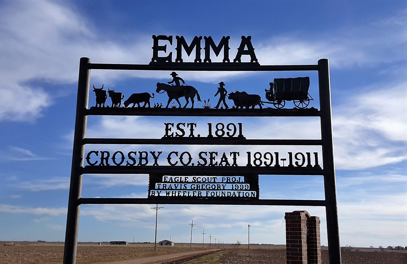
The central location made Emma a consideration for the county seat and since residents of Estacado were already drifting to the newer community, an election was held in the Fall of 1891. Emma squeaked through by a six-point margin (109-103). The residents of Estacado moved the courthouse and other prominent buildings to Emma and the town prospered for awhile. By 1910 there was a population of 800 and Emma had all essential businesses including a bank and newspaper.

Emma's future seemed bright up until it was bypassed by the railroad in 1910. The shoe was now on the other foot and Emma lost out to the new town of Crosbyton in an election held in September of 1910. This election was also close (198 to 120) and soon the former townspeople of Estacado and Emma were moving again - this time in an organized exodus that consisted of steam engines, mules and most of the male population. The former courthouse was dismantled and taken to Cedric and the next year the Emma post office moved to Ralls. Today only the historical marker is left.

History lesson is over. Now back to Geocaching. Cemetery caches are one some of our favorite caches to find. This one happens to be a virtual cache (GCHA69). Now since we've been Geocaching, we must have been to a hundred or more cemeteries. THIS is a first! Every headstone we've ever seen said "Died", "Death", or simply "D". Poor Tommie Horrell had the truth told about him. He was MURDERED on Jan 5, 1894 at the young age of 24.


While we ended the day with only ten caches, they were really good quality caches. Unusual houses, history, hiking, a cemetery... this is why we like this game! Where do we go to tomorrow? You'll just have to come back and see!

Wednesday, February 24, 2016

2016-01-10: Geocaching Around Lubbock Texas

Because it was so cold yesterday, today we decided to stay local and do some urban Geocaching around Lubbock. Our first stop was to see the Buddy Holly Center and Museum. It was closed this early, but we did get to see the giant glasses (a virtual cache GC6E04) and the memorial statue (GC640VA). Buddy Holly's hometown was Lubbock, Texas and they certainly pay tribute to him.


Not too far away over at the Eastlawn Memorial Gardens, is another virtual Geocache (GCC1AB) at Buddy Holley's gravesite next to his parents. There'a another Geocache here (GC1KJJV) highlighting the supposedly haunted aspect of this cemetery. This cemetery is one of the largest in Texas with over 60,000 graves and was established back in 1892.


Also while in the cemetery and with all the snow on the trees, Candy couldn't help it but to go over to one of the trees and shake all the snow off the branches! By selecting one of the taller branches, that also meant it comes down on her head too.


Exiting the backside of the cemetery brought us out to the Canyon Lakes Park. Within the city limits of Lubbock is the Yellow House Canyon, a narrow and shallow channel. The city created a series of small dams that created a series of narrow lakes. And Canyon Lakes Park was created. There's also a series of eight Geocaches around the lake as well. And of course we can't just leave them without looking first!


From there, we drove over to the campus of Texas Tech. Since it was Christmas Break, there weren't many students still here which made Geocaching a little easier. Though most of the ones we looked for, we could not find. We did see some very nice statues.


So that was it for today. We did learn a lot about the local history. Now time to go back to the apartment and thaw out again.

Wednesday, February 17, 2016

2015-12-06: Just How Many Cemeteries Can One Visit in a Single Day?

Today was cemetery day! Well not really, but it sure seemed like it. We decided to go north today up to San Augustine. Candy is from St. Augustine, FL, so we wanted to see what the sister city in Texas was like. And pick up a new county.

Driving up US-96 on this cool Sunday morning, we turned west on Hwy 255 in Brookeland. Our first Geocaching stop was a Travel Bug Hotel (GC5PX6D) near a church. We had three TB's with us, so now they've checked into a hotel to be carried along by the next cacher.

A couple more caches later and we drove over by the dam to get a good view of Lake Sam Rayburn.


After enjoying the scenic views, we drove back over to US-96 northbound and into San Augustine. It looked like a nice little town, established way back in 1832 with land owned by Thomas S. McFarland. The town was named after Presidio de San Agustin de Ahumada.


The first cache (GC2TK08) in San Augustine for us was the grave site for Rev Samuel A. Williams. Born in Tennessee in 1804, he became a Methodist minister in Tennessee, Alabama, and eventually East Texas in 1938. He died in 1866 and was buried at his home in San Augustine.


The first cemetery cache for the day was the Lewis Family Cemetery (GC2TK08). Located just outside the city limits, this sad, neglected cemetery has just a few headstones visible.


Back into civilization and in the town center was our next cache (GC2TJX3) and a step back into history. This once barbershop still has some of the old sinks and shoe shine chairs left in place. According to the cache owner, it was one of the last old time barbershops in the county before it closed.


Cemetery #2: The San Augustine City Cemetery (GCNNVG) with interments dating back to the 1830's.

Not related to Geocaching, but as you wander about going from cache to cache you still see some interesting things. Like this structure which appears to be some sort of water wheel that may have powered some sort of mill equipment. Not too sure. It was just next to a house down some back road. 


Also in town was this old church building. There was a cache located at the nearby Methodist church, but I thought this smaller one actually had more character. I think the Methodist church as a congregation was older, but the building was newer. This Episcopal church was built in 1869.


Cemetery #3: Liberty Hill Memorial Garden (GC341P2) (GC341PD)
Cemetery #4: Liberty Hill Cemetery (GC341NP)
Cemetery #5: Fischer Cemetery (GC341NT)
Cemetery #6: Horton Cemetery (GCPF63)
Cemetery #7: Mt Zion Church Cemetery (GCPF6W)

Another cache (GCJ130) brought us to some history which we didn't really get a chance to explore because it was closed. It took us to the site of Mission Delores which dates back to the very early 1700's. They had some short trails which snaked through the Piney Woods a little bit which was a nice stroll.


We then drive over for another cache by the boat ramp at City Lake. It was a nice scenic and relaxing view, so we just hung out for a while before continuing on.


Cemetery #8: Roberts Cemetery (GCRRZA), though we had to DNF this one.
Cemetery #9: Parker Cemetery (GCPF6X)
Cemetery #10: Chinquapin Cemetery (GCNNW7), began with the Loggins family in 1839.

Next cache (GCRVNZ) was a roadside memorial for the 7 Columbia Crew members. On February 1, 2003 as the space shuttle was reentering the earth's atmosphere, it broke apart and all 7 of the crew were lost over the piney woods of East Texas. Near this site, a mission patch was found. A small makeshift memorial consisting of a bed of white rocks with 7 American flags were placed on the shoulder of the highway.

Cemetery #11 Dickerson Cemetery (GCNNWH)


Overall we visited 11 cemeteries and found a total of 28 caches, learned some history, and saw some great sites in a lovely old town. Where to next?

Thursday, February 11, 2016

2015-10-17: Geocaching and Hiking at the Golden Aster Scrub Nature Preserve

Today we decided to try someplace new. We drove west down to Golden Aster Scrub Nature Preserve. It's a Hillsborough County Park just off of I-75 near Gibsonton, FL. The day started out bright, sunny and cool around 9:30. But it didn't stay cool very long and there wasn't much for shade either!

After 4 hours and hiking 5.5 miles of scrub later, we called it quits. We did find 20 Geocaches with only 1 DNF. We'll definitely have to come back another day to finish Geocaching when it cools off more!


Wednesday, February 10, 2016

2015-09-07: Labor Day Weekend Geocaching in Georgia

YAY! It's a long 3-day weekend for Labor Day. That calls for a Geocaching road trip! Hmmm... where to? One of our goals is to complete our Geocaching by county map. With Florida already completed, the next closest is Georgia. So a Georgia road trip is the order of the weekend. So we pack the bags, head up I-4 to I-95 north. When we arrive in Jacksonville, we exit onto US-23 up to US-301.

Our first stop is in Folkston, GA and Charlton County. We continued up US-301 north picking up caches within each new county. Reaching Statesboro, GA, we decided to call it a day. On day #1 of this weekend road trip, we picked up 9 caches.

Yesterday started out with a few VERY creative caches put out by one cacher down the same dirt road. Even though we already had the county, there are some you can't bypass. I won't explain them, but the next few photos are the caches. A couple of them took a little detective work figuring out how to get them open and finding the log sheet in order to sign it.


We stayed on US-301 all the way up towards the SC state line in order to get a cache at the Georgia Welcome Center. This is the OLDEST welcome center still in use in the country, opening in 1962!


After the Welcome Center, we did a u-turn back south to GA-25 west. Then following some rural back roads we found another creative cache using a gator head at McKinneys Pond and Mill Creek. On the property was also this old house about to fall into the creek.


A few more caches here and there picking up new counties, we made our way over to the town of Jackson. There along Lake Jackson and the Lloyd Shoals Dam was the "Cache Across America" for Georgia. It was a nice little hike through the woods. Even the GeoDog Max got in on the action here. From there we drove down to Macon and called it a day, having found 14 more caches and more counties.


This morning waking up in Macon, it was the last day for our weekend road trip. We had some more caches and more counties in the works before arriving at home back in Florida. We followed US-80 south down to GA-26 over to US-23 south. It was a great weekend. We found a total of 32 caches for the weekend and 20 new counties for Georgia. A lot of history, some hiking, and some unusual and creative caches.