Showing posts with label river. Show all posts

Sunday, September 3, 2017

2017-07-05: Driving Back to West Texas Day 2: Alabama, Mississippi, Louisiana, and Texas

Welcome back to Day 2 of my road trip from Florida back to West Texas. Today begins in Evergreen, Alabama. After a good nights rest at the hotel and a quick hotel breakfast, it was time to hit the road again. I'm still following the backroads of US-84, trying to stay off the interstates as much as possible. At the same time Geocaching and sightseeing along the way.

My first stop was to get gas and a Geocache (GC2APKW) at the Love's Travel Stop for Conecuh County, Alabama. A quick fuel up and find and I was on my way.

The next county over was Monroe County and also the next cache. The Geocache was by a historical marker for Fort Claiborne (GC178A3). Built by General Ferdinand L. Claiborne during the Creek Indian War of 1813-1814 as a base for his invasion of the Alibamo country with the U. S. Regulators, Lower Tombigbee Militia, and friendly Choctaws. Claiborne's campaign culminated in the American victory over the Creeks at the Holy Ground. I was hoping to see something other than the sign, but nothing of the fort remains.

Moving on to Clarke County and a quick roadside cache stop (GC2MYZ7) to claim a find and to continue making good time.

Choctaw County was the last along US-84 in Alabama and a county needed. I stopped at the Bladon Springs State Park for an Earthcache (GC3JAB8). The springs here, named after the original property owner, James Bladon, were first opened to the public as a therapeutic spa in 1838. Seven years later, state geologist and University of Alabama professor Richard T. Brumby and two colleagues from the University of Louisiana traveled to the springs to conduct a comprehensive analysis. Brumby reported his findings in a 27-page book, "An Analysis of the Bladon Springs," published in 1845. Following the report, the tourist trade increased so much that a resort was built, including a bowling alley, cabins, skating rink, and last but not least, a Georgian Revival hotel that could house 200. The resort is gone, but four springs remain, one of which is still covered by the gazebo from the resort days.

I gathered the information I needed for the earthcache and took a few pictures. There were two more caches in the park and I was tempted to take the short hike after them. But the road ahead was calling and I wanted to get some miles put behind me. So across the state line into Mississippi I went.

Wayne County was up first with a quick roadside cache (GC38PV9). After that was a quick Virtual Cache (GCE7A7) in Jones County. Continuing westbound on US-84, I skipped right through Covington County having already found a cache there. Then quick park and grab roadside caches in the remaining Mississippi counties of Jefferson Davis (GC388J0), Lawrence (GC1RNA2), Lincoln (GC35WGT), Franklin (GC35WGT), and Adams County (GCTV6P).

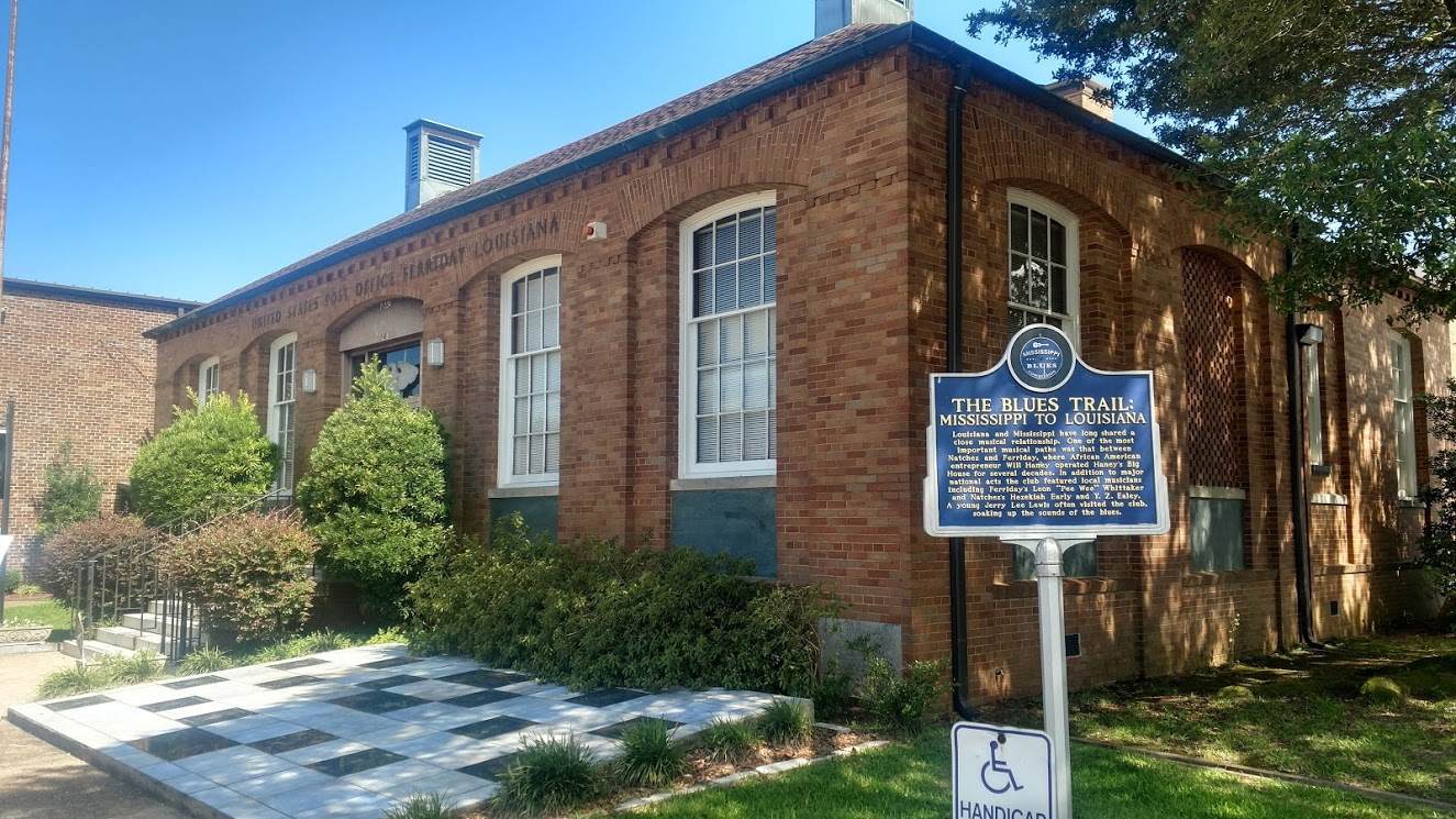
Crossing the state line into Louisiana, they have Parishes instead of counties. My first stop in Concordia Parish is the Delta Music Museum (GC1D5VZ) along the Blues Trail. Louisiana and Mississippi have long shared a close musical relationship. One of the most important musical paths was that between Natchez, MS and Ferriday, LA, where African American entrepreneur Will Haney operated Haney's Big House for several decades. In addition to major national acts the club featured local musicians including Ferriday's Leon "Pee Wee" Whittaker and Natchez's Hezekiah Early and Y. Z. Ealey. A young Jerry Lee Lewis often visited the club, soaking up the sounds of the blues.

I had arrived to the museum just as it was closing up. She watched and we chatted as I searched for and found the Geocache. After signing the log, we went inside and she gave me a quick tour of the museum.

Two more quick caches in LaSalle Parish (GC23AXN) and Natchitoches Parish (GC4XHMC) before arriving in Sabine Parish and a cemetery cache (GC2D9MA). Fender Cemetery has over 300 interments dating back to 1851. One of the spookier graves is of this red brick tomb that seems to have been elevated a few inches. Kinda makes you think that the undead comes crawling out at night searching for innocent victims to carry back to the underworld.


I crossed the Sabine River into Texas at sunset and got a spectacular view. Driving nearly 600 miles today, I've got around 450 miles to go. Can't wait to get home to see my Beautiful Sweet Wife!

2017-07-04: Driving Back to West Texas Day 1: Florida, Georgia, and Alabama

So today's the day to hit the road and drive back to West Texas. And of course this won't be a boring I-10 forever non-stop westbound trip. No way. I just can't take a road trip without Geocaching and sightseeing. Plus there's another opportunity to pickup some new Geo-Counties! So I'll be taking the scenic byways of US-84.

I woke up just after 5 AM, gathered my things and quickly hit the road. From Umatilla, Florida heading north on SR-19 through the Ocala National Forest, west on SR-40 and over to I-75 northbound to Georgia. First on my Geocaching county list was Echols County, Georgia.

Non-stop express driving all the way up to US-129 in Jasper, FL, taking that exit to head directly north into Echols County. Now when most people travel they book a flight because it's all about the destination. I prefer to drive because it's more about the journey. The destination will be there all the same, but on a journey there's much more to discover. While passing through Jasper, I spotted this old forgotten rusty Jeep sitting out behind this business among other piles of scrap metal objects. Something about the sadness in the way it looked caused me to slow and make a u-turn for a photo capturing that moment and emotion.

Crossing the border into Georgia and Echols County, there were three caches along the route and I needed to find at least one to achieve the "Found County" status.  The first cache (GC4CJNF) on my list was located at the Echold County Museum and Statenville's oldest house. A combination of No Trespassing signs, fenced in property, and the neighbors outside getting ready for a July 4th BBQ, and I decided to skip this one and move on. It has since been archived.

Second on the list was "Down by the Riverside." (GC5Q27T) Just out on the west side of Statenville along the Alapaha River is a boat ramp and my next cache location. After spending about 10 minutes looking without any luck, I gave in and walked down by the riverside for some photos of the calm muddy waters. Two down, one to go.


The last cache along the way and my last hope for a find in the county was a Country Cache (GC5DBXA). Stopping along the road side, I quickly saw the spot that looked like it might have had a cache placed there but without a container. I continued looking around just in case, swatting away mosquitoes on this humid day, hoping that maybe I just overlooked it. But in the end I had to drive away without a smiley, leaving Echols County still unfound. Strike three, I'm outta there.

The next county was Lowndes County where I-75 runs through Valdosta. Having already cached here, I drove through to save some time. It was there in Valdosta where I picked up highway US-84 for my long journey westbound.

Brooks County was next in line where a quick stop at Quitman's Hangout cache (GC39155) gave me my first caching find and first new caching county for the day. Hopefully this would be the beginning of a caching streak!

Continuing west on US-84, I skipped through Thomas County having found a cache there on a previous road trip, I arrived into Grady County. Before I arrived at my next Geocache, I passed by this old small roadside cemetery and just had to pull over to explore. It was the Lester Poulk Braswell Pearce Cemetery. There are 60 interments there with many unknown graves that no longer have any readable markings on them. The oldest known grave is that of a Rev Mann Dutton who died in 1857 at the age of 61. I found an article that said as recent as 2001, this cemetery was so overground with weeds and vines that it took two hours just to walk through and find all the graves. Glad someone has cleaned it up.

A few miles down the road was another cemetery and my next county cache (GC26MCP). Dr. Joseph Griffin was a black physician. In 1935 he began practicing medicine in Bainbridge, Georgia. He built a 50 bed hospital and established the Southwestern Medical Society. In honor of south Georgia's first black physician, the Dr. Joseph H. Griffin Memorial Gardens was created in Grady County.


Another quick cache find in Decatur County (GC152M9) and I was off to the next one. A short detour to the north up into Miller County and a bridge cache (GC5RNRN). Just down from the bridge was this old church and another cemetery. The cemetery is still in use today. I did see this one dead tree that inspired a photo.


After the short detour, I made my way back south to US-84 and into Seminole County to find my next quick cache (GC5Y3A8).

For the last county in Georgia, it was off to picturesque Howard's Mill in Early County (GC27247). I couldn't find anything on the history of the mill. Though it appears to be used as a private home or for special events now.


Arriving in Alabama, the first two counties were Houston and Dale Counties. I had already found caches there so it was another chance to make up some time breezing through. Next on the list was Coffee County and the town of Enterprise, AL. By this time it was getting late in the afternoon and surprisingly this was the only town that was having a 4th of July celebration around the town square. There was a carnival setup in the square and it appeared that the whole town may have been in attendance.


I had three caches on my radar there. The first being a virtual cache (GCAC2D) located at a statue on Main Street as you enter the downtown area. I can't say much more about it because I'd be giving away some answers you need to claim the cache.


The second cache on my list was at the old train depot (GCT3MX) built in 1903. The first freight shipments and passengers came here on the Alabama Midland railroad in 1898 immediately after construction of the roadbed. That was also the year when most of the brick business buildings downtown were completed.

The one that caught my eye was the Rawls Hotel. This original two-story brick structure also built in 1903 by Japeth Rawls, developer of some of the earliest turpentine plants in Coffee County. This building was remodeled in 1928 and three-story wings added by Jesse P. Rawls, founder of the first electric power system in Enterprise. The Rawls Hotel was the center for business and social gatherings until its closing in the early 1970's.


My last cache to see in Enterprise was at the old jail (GC2FKAY). Unfortunately it was closer to the town square and busy with people coming and going for the festivities. And me being in a large U-Haul, I figured it be best to just pass on this one until next time in the area.

Covington County was the next to enter and my last cache of the day. It was just a quick and easy WalMart cache (GC24TFV).

I ended the day in Evergreen, AL after 431 miles of driving. Claiming some new counties for my Geocaching list, seeing some sights, and learning some history. Tomorrow is a new day. I hope to make it across and into Texas, but there's still 1300 miles to get all the way back. At least halfway would be good.

See you then.

Sunday, May 7, 2017

2017-04-17: Judge Roy Bean, an Old Fort, Cemeteries, and the Pecos River

Well our weekend is over and we drove back home along the Texas / Mexico border. Before leaving Eagle Pass, we drove around town checking out some of the historical spots.

Our first stop was down along the border at Fort Duncan. A temporary post called Camp Eagle Pass was established at the start of the Mexican War in 1846 by Captain Sidney Burbank with Companies A, B, and F of the First United States Infantry. In November 1849, the post was renamed Fort Duncan, honoring Col James Duncan, a hero of the Mexican War. The fort consisted of a storehouse, two magazines, four officers quarters, a stone hospital, in addition to quarters for enlisted men. (The red brick building above was the hospital.)

The fort served as a frontier outpost near the trail of California emigrants; a base of operations against hostile Lipan Apache Indians. In 1851 it became the headquarters of the First Infantry. By 1856 the garrison included units of mounted rifles and first artillery. Abandoned in May 1859, the post was re-garrisoned by Robert E. Lee in March 1860 because of border assaults by Juan N. Cortina, desperado of the area. At the outbreak of the Civil War in 1861, the fort was again abandoned only to be occupied later as "Rio Grande Station", by Confederate forces.

In 1861, Fort Duncan was re-garrisoned by the 9th Infantry and headquarters company of 41st Infantry under Col William R. Shafter. Seminole-Negro Scouts, organized here on August 16, 1870, played a large part in ridding Western Texas of Indians. After 1883, the post declined in importance; known as Camp Eagle Pass.
Fort Duncan played a part in aviation history when the first military cross-country flight, from Fort McIntosh in Laredo, landed here in 1911. Its use as a training camp continued during World War I. Mexican border troubles in 1916 again brought reoccupation.

By 1932 the Army abandoned the post. In 1938, the fort property was purchased by the city of Eagle Pass, for use as a Park and Recreation area. The infantry barracks were leased by the Local Council of Boy Scouts.

In 1939 the barracks became the Fort Duncan Country Club and remained as such except during World War II when it was also an officers club for the Eagle Pass Army Air Force Advanced Flying School.


After walking around the fort, we drove north a few blocks to the downtown area looking for the post office. We didn't need the post office, but I had read about an interesting spot on the Find-A-Grave website. This spot, at Rio Grande and Monroe in Eagle Pass, is approximately the site of the first city cemetery here. For some reason, after the 1880's the cemetery was abandoned. It was later developed on and paved over, effectively destroying it. During the construction of a post office nearby in the 1950's, a tombstone was discovered, as well as several graves.

We never did find it though. I wasn't thinking that the current Google search for post office was a different post office from the 1950's. It wasn't until I looked the website again and re-reading the description that we were a few blocks away. Maybe next time passing through we'll find it.

From there we drove over to Shelby Park along the Rio Grande River. The park is mostly used by those leaving their cars on the Texas side and walking across the International Bridge into Piedras Negras. There were also about a half dozen border patrol agents getting ready to launch two airboats for patrol. The photo below looks over into Mexico and the bridge would be located off frame to the left.


Well now it was time to finally hit the road and put some miles behind us. We still had almost five hours of driving with 10 Geocaches and some sites to see along the way. Driving north along US-277 we found three quick caches: one at a cemetery (GC4N23X) and two roadside caches (GC29WHF and  GC35ZC8), before arriving in Del Rio for lunch.

Westbound on US-90, our next cache was the Ye Olde 4-Wheeler (GC36XP2) which brought me to stop and capture a photo of this old west wagon before it completely fell apart.


Next was another cemetery cache (GC3B4NE) in Comstock. In 1882 and 1883, the Galveston, Harrisburg, and San Antonio Railroad built track through Val Verde County and the town was established as a station and named for John B Comstock, a railroad dispatcher. The graves date back to 1883, but there were three that really caught my attention. No stories behind them. It's just the emotion and photo opportunity they gave me. Like this first one of Lucy Denmead who couldn't escape death in 1902, or did she?


Next cache (GC5N4E2) was at the rest area where US-90 crosses the Pecos River. I once passed through here 10 years ago while I used to drive an 18-wheeler, long before this rest area was built. Back then I had to park on the shoulder. The only thing I do remember was the remains of the old highway which ran down towards the river to the original bridge built in 1923 and destroyed by floodwaters in 1954. The current Pecos High Bridge is 1310 feet long and 273 feet above the water, and is the highest highway bridge in Texas.

At this southern end of the Pecos River it empties into the Rio Grande just a half mile down.


Just down the road was another cache (GC2NZHP) and another bridge. These two bridges cross Eagles Nest Creek Canyon just north of the Rio Grande River.


In nearby Langtry was our next cache (GCK9CH) and someplace I've wanted to stop for a long time, the "Law West of the Pecos." In 1882 the lawlessness was so bad that the railroad asked for help from the Texas Rangers. The closest legal authority was in Fort Stockton over 100 miles away. With the blessing of the Rangers and the railroad a proprietor of a store housed in a tent in Vinagaroon was appointed as the first Justice of the Peace in Pecos County (now Val Verde County) August 2, 1882.

Roy Bean never one to stand on ceremony tried his first case the week before the appointment. In 1883 the judge moved his business and his court to Langtry, Texas. There he built the Jersey Lilly Saloon, Court Room and Pool Hall. Some legends cite Bean as being a "hanging" judge, but there is no record that he ever sentenced a man to be hanged. The only law book the Judge ever owned was the 1879 Revised Statues of Texas. Occasionally he actually used it.

The "Judge" had great admiration and fascination for the famous English actress Lillie Langtry. She was internationally know as the "The Jersey Lily so he named his establishment after her. A sign painter commissioned (for food and drink) to letter the sign misspelled "Lily".

One of the most colorful stories about the Judge is true. He successfully promoted the Maher - Fitzsimmons prize fight in February 1896. It was staged in defiance of U.S. and Mexico law on a sand bar in the middle of the Rio Grande River.

A couple more quick caches along the way home and that was the end of another adventurous weekend of exploring the history of the Old West Texas. Thanks again for stopping by and following along in our adventures. Until next time, happy trails.

Sunday, October 23, 2016

2016-10-01/02: Road Trip to Florida; Cowboys Stadium, Cemetery, History, and Duck Dynasty

ROAD TRIP! On today's blog I'll be covering a two day road trip from West Texas to Florida. We hit the road early on the Saturday morning of October 1st. Having 1430 miles to drive in 2 days, add in fuel and food stops, and of course some Geocaching too, we've got a lot of driving ahead of us!

After leaving Monahans around 6:00 AM, a couple of hours later, we pulled into a McDonald's in Sweetwater for some McMuffins. And of course there just happened to be a Geocache (GC38PN6) there too so we had to find it as well. Within a few minutes, we were on the road again. Finally in Abeline we spot a Starbucks near the I-20 exit so we grabbed a couple coffees and another quick Geocache (GCWC1E).

Those first two Geocaches were unplanned and just happened to be nearby when making other stops. Hey, you can't NOT look for them when you're so close right?

But we did have some caches planned. When we got into Ft Worth, TX, we merged over onto I-30 eastbound and into Arlington. There we stopped for our first scheduled virtual Geocache (GC90F2). It was a beautiful statue of three horses surrounded by water fountains at this shopping center. We got the required info needed to claim the find and a few photos with GeoDog Max.


On our way to the next planned virtual cache, we passed by the Dallas Cowboys Stadium as well as the Texas Rangers Field. Well we just had to get a photo there too and grab the cache (GC15RDP) across the street!


Around the corner about a block away was a nice park and another planned virtual cache stop (GC7029). From there we got a good view of Cowboys Stadium. There were also these large Caelum Moor Stones around the park and a multi-stage Geocache (GC30RJB), from which after gathering information from the stones, we were able to find the final stage. The five freestanding granite sculptures weighing a total of 540 tons will enhance the environmental landscape along Johnson Creek in Arlington’s Entertainment District.

The stone monuments range in height from 8 to 30 feet. The Latin name “Caelum” is derived from a constellation in the southern skies known as the sculptor’s tool or chisel. “Moor” refers to the windswept landscapes of Scotland. The celtic names of each of the five groupings reflect the ancestry of the sculptor’s patron. Caelum Moor was commissioned in 1984 by Jane Mathes Kelton, CEO of the Kelton Mathes Development Corporation and heir of the Scottish-American television magnate, Curtis Mathes. According to the sculptor, Kelton wanted the artwork to serve as a centerpiece for a proposed business park development along I-20, reminiscent of the ancient sites of Scotland and England and reflecting of her family’s heritage. From 1986 to 1997, Caelum Moor was located at the headwaters of Johnson Creek along Interstate 20. In 1997, the sculpture was donated to the City and stored to make way for commercial development. Caelum Moor was once listed on the Smithsonian Institution’s National Registry of Art in Public Places. They were relocated to this park in 2009.


Our main reason for stopping here was to get Tombstone (GC62), a multi-cache and the oldest Geocache in Texas! Hidden on September 26, 2000, this cache also fills another empty spot on my Jasmer calendar. It's had over 1500 finds since then. It's placed in Doug Russell Park and is three stages. The last two stages are near the location of the Berachah Home and Cemetery. We walked over to the first stage easy, got the info we needed for the final north coordinates. Then we walked over to stage two and got the needed info for the final west coordinates. That's where my problem began. After frustratingly searching for 30 minutes (Candy and GeoDog Max had long been back to the car with the a/c on) for the supposedly easy final stage, I finally decided to recheck my coordinates. Well the north coordinates didn't save correctly in my phone and therefore I was searching in the wrong place! Once I put the correct coordinates in and began searching the correct location, I found it within minutes. YAY!!

The Berachah Rescue Society was organized at Waco in 1894 by the Rev. J. T. Upchurch for the protection of homeless girls and unwed mothers. Nine years later he opened the Berachah Industrial Home at this site. Ten buildings were located here including a print shop for publication of the "Purity Journal." The cemetery which contains more than eighty graves, was first used in 1904 for the burial of Eunice Williams, one of the residents. The home closed in 1935, but the site was used until 1942 as an orphanage run by Upchurch's daughter Allie Mae and her husband Frank Wiese. Most of the graves here are marked without names or dates. Many more just have a first name and year died.


Finally back to I-20 heading east. We spent a couple of hours in the Arlington area and now we have to make up some time. So no more stops until we needed another gas stop in East Texas. And of course while the gas is pumping I checked my phone and there was a cache there too (GC4EE5P). A quick find and back on the road. It was soon getting dark and we drove over halfway into Louisiana.

As it turned out the hotel we stayed in was located in West Monroe, LA. And just around the corner was the Duck Commander Headquarters! The location of the Duck Dynasty TV show is filmed here. So before heading down the highway, we had to stop by for a few photos.


We didn't stop much on Sunday because we still had over 760 miles to go. But we stop just before the Mississippi River at Grant's Canal for another virtual Geocache (GCGDM2). During the summer of 1862, the Union's first attempt to bypass the Confederate Army at Vicksburg by digging a canal across DeSoto Peninsula failed. By January 1863, the Union had reoccupied the Louisiana shore opposite Vicksburg. Gen Ulysses S. Grant ordered work on the canal resumed. The canal was to be 60 feet wide, 1 1/2 miles long, and deep enough to float any vessel on the river. Ground was broken on January 30, black work gangs assisted by fatigue details from the Union Army began to work. Later, steam pumps and dredge boats were employed. To stop the work, the Confederates placed several big guns on the shore opposite the canal's exit but the work progressed. On March 7, the upper dam gave way, flooding the entire peninsula. Grant's Canal had failed. After gathering the information we needed to qualify for the cache find, we continued eastbound.

After about 3 1/2 hours later on US-98 in South Mississippi, it was time for a break to stretch our legs a bit. I looked up some caches ahead of us and found a cemetery just off the road with three caches (GC445DQGC445DVGC445DP). 

There was a gas and food stop along the way, but nothing to write about. We arrived in St Augustine, FL about 9:30 PM. A long day of driving. Sleep was soon thereafter!

Sunday, May 15, 2016

2016-04-03: A Presidential Geocaching Adventure, History and More Cemeteries

Today's Geocaching Adventure took us on a Presidential drive to a historical home. After a busy 6-day work week, it was good to get out and do some exploring. We decided to relax this time out instead of our recent hikes. Taking time for a good home cooked breakfast, we headed east on I-20 into Midland, Texas. Our first stop was a Starbucks since we haven't had one in a long while!

President George W. Bush childhood home.Our first Geocache was a Presidential Virtual! (GC89D4) The home of TWO Presidents! From the historical sign out front:

"George Herbert Walker Bush and wife Barbara came to Texas in 1948, moving to Midland with their young son George Walker Bush in 1950. They bought this house in 1951 and while here faced the loss of their daughter Robin and celebrated the birth of two sons. The years spent here were vital for young George, who attended Sam Houston Elementary, made lifelong friends and played baseball. The family moved to a larger home in 1955 and then later moved to Houston.

This c. 1939 traditional style house reflects transition from Tudor to Ranch detailing. Unique in history, it was home to two Presidents: George H. W. and George W. Bush; two Governors: George W. Bush (TX) and Jeb Bush (FL); and First Lady Barbara Bush."

However, while we were there it hadn't opened yet for the day. It was Sunday around 11:00 AM and we weren't up for waiting a couple of hours for an inside tour. Maybe next time we're in the area.

George W. Bush childhood home

Leaving the downtown presidential home, we continued east several miles outside the city of Midland to another of Texas' historical marker caches. This one was located near Midland County's first producing oil well (GC2A3Q4). There wasn't much to actually SEE at this spot, but here's what the historical marker reads:
The discovery of oil in the Permian Basin during the 1920's helped sustain the area economy during The Great Depression, and many oil and gas companies established headquarters in Midland. Not until the 1940's, though, did Midland County begin seeing its own productive wells. Geologist H. L. Beckman worked with the Rowan Drilling Company to stake out Humble Oil and Refining Company's No.1 Mrs. O.P. Buchanan oil well at this site. They spudded the well on September 14, 1944 and completed it on November 6, 1945 at a total depth of 12,574 feet. The well produced 332 barrels of oil in 29 hours and became Midland County's first producing oil well. It was plugged on August 1, 1947.
On the way to our next cache, we arrived in Garden City and the Glasscock County Courthouse and Jail. On May 9, 1893, a little over one month from the date of Glasscock County's formal organization, the first county commissioner's court issued bonds to erect a combination courthouse / jail buildings. The small 2-story structure was completed on February 12, 1894. Originally, the ground floor was used for court session and the 2nd story for the jail. On August 27, 1910, a larger building was completed and has been in continual use since 1910. The smaller building was then used entirely as the jail until a new one replaced it in 1980.

A few blocks away was the Garden City Cemetery and our next Geocache (GC30CB1). We couldn't get the cache located in the cemetery as there was a gardener mowing right near the cache location. The one we did find was located outside the cemetery near the entrance.

The next cache on the agenda was for another Texas ghost town (GC14VV1). Not much to see here except for the historical marker:
The pioneer settlement of Cummins developed at this site about 1890 around the saddle and harness shop of the earliest permanent settler, Mississippi native Robert Benjamin Cummins (b. 1848). A post office the following year the nearby town of Sterling City (1.9 miles east) was founded. The two towns became rivals for the designation of county seat when the Texas Legislature created Sterling County from Tom Green County on March 4, 1891. An intense publicity campaign developed, aided by the writings of the respective town newspaper editors: W. L. Thurman of the Cummins paper, the "North Concho News", and S. R. Ezzell of the "Sterling Courier". An election, conducted May 20, 1891, appeared to be a victory for Cummins until several voting boxes were dismissed for technical reasons, resulting in a tie. A second election on July 7 gave Sterling City a 13-vote margin and it was named the county seat. Most Cummins businesses and residents had moved to Sterling City by the end of 1891. Nothing remains of the early townsite, which once included a school, saloon, meat market, mercantile, blacksmith shop, and grocery stores.
Now that you know the story of the rivalry between Cummins and Sterling City, let's drive over to see what all the fuss was about. Arriving at the newer Sterling County Court House, you can still see the original 1912 County Jail building to the right of it. Like most of the old west jails we've seen, the lower level included living quarters for the sheriff and this one had seven jail cells on the upper floor.

Sterling County Courthouse and Jail

Across the street from the courthouse was this restored 1910 Hotel. Although I think the upper floors are still used as guest rooms or apartments, the lower floor appears to be an antique store.

Old Sterling City Hotel


A few blocks away was an old train depot. There wasn't a cache placed there, but I noticed the historical sign pointing the way to it and had to check it out. Attracted by the area's livestock production, nearby shipping points, and the financial support of the town, the Concho, San Saba & Llano Valley Railroad began building a line to Sterling City in 1909. A boxcar served as the depot until this mission revival building was completed. Highway and pipeline construction caused a decline in rail traffic and the line closed in 1958. Only this restored depot remains as a reminder of the early rail service that helped develop the area, and is now used as a community center.

Old Sterling City Train Depot

Our last cache here was at the Sterling City Cemetery (GC47QPH). Still in use today and well maintained. But a few miles down the road was another of the Texas ghost towns and the only thing that remains is the Montvale Cemetery (GC14PMK).
The community of Montvale was established in 1884 when the pioneer settlement of St. Elmo was relocated here. Then a part of Tom Green County, Montvale was located on the Shafter Military Trail, an early road from Fort Concho. A community school, the earliest in the area, was in operation by 1886. Three years later the town was platted by H. B. Tarver, the surveyor for Tom Green County. It is believed the settlement was named for a nearby hill referred to in Tarver's field notes as Mt. Vale. Early businesses in Montvale included the saddle and harness shop of R. B. Cummins and the general store and blacksmith shop of B. Z. Cooper. The town was also the site of a Methodist church, a hotel, a post office and a variety of stores. About 1889 R. B. Cummins started the town of Cummins (5.4 miles northwest) upriver from Montvale. Both settlements began to decline in 1891 with the establishment of Sterling City (3.5 miles northwest) as the seat of government for the newly created Sterling County. A community cemetery is all that remains of the townsite of Montvale, a pioneer settlement that played an important role in the area's development.


Just south of the cemetery was our next cache at the Sherwood Lane Bridge (GC14VW4). It hadn't been found in two years and sad to say we hadn't find it either. It is an old single lane bridge still used when the small river flows too deep over the gravel road. And from the looks of the debris under and around the bridge, the water appears to have risen 3-4 feet above its current height! Probably why we couldn't find the Geocache. Maybe swept down river some where...

Sherwood Lane Bridge


Continuing down US87 south, we happened upon a roadside attraction and our next Geocache (GC1QBG9). I'm not sure who Minnie Brown is, but she must have a following here in this part of West Texas. There were many displays here to look at along the side of the road at this house, but I only posted a few. You'll have to go and check out the rest of them. It's FREE and all you'll need to do is pull safely off the highway onto the wide shoulder area.


Our final stop brought us to the historical marker for another Texas ghost town (GC14VTW). There wasn't much anything here to see and so I didn't take any photos. The town of Broome, on the North Concho River and U.S. Highway 87 ten miles southeast of Sterling City in east central Sterling County, was founded in 1924 as a station on the Panhandle and Santa Fe Railway and was named for early rancher C. A. Broome. The community acquired a post office that was discontinued in 1939. In 1947 the settlement had a combination store and filling station and a population of twenty-five. Its population was eighteen in 1980, and by 1990 no population figures were reported for the community.

That was it for today. Sorry for the delay in writing this blog post. With me working 60+ hours a week now it has cut into our Geocaching time on the weekends. But stay in touch and check back soon. We hope to be able to get back to our weekend Geocaching Adventures shortly.