Showing posts with label school. Show all posts

Saturday, February 5, 2022

2020-09-19: Geocaching Roadtrip Through Georgia Finding Abandoned Buildings, Old School, and Santa Claus

Hello Everyone. Well we had a 4-day weekend off from work so I decided a spontaneous quick trip down to Florida and back would be good to fill the time. We packed a weekend bag and left the Lake Norman RV Resort in North Carolina on Thursday morning, arriving at a hotel on Daytona Beach. Friday was spent visiting family. Todays' blog is about our Saturday drive north through Georgia, sightseeing and geocaching along the way. So climb onboard the GeoJeep once again and let us see what we can find...


Driving north on I-95 and arriving in Brunswick, Georgia, I exit onto US-25 / US-341 to take the backroads and byways so that we can enjoy the ride more than the Interstates. It didn't take very long to find a treasure and reaffirm the reason we prefer the backroads of rural America. Passing through the small community of Gardi, Georgia, I spotted this old red brick building and just had to turn around for a closer look.


The Gardi area was being settled by the Street Family during the colonial days of Georgia. Around 1900 and as the community was growing, this brick building was constructed by the Odom Family and first used as a post office and general store. The Fore Family purchased the building around 1940 and turned it into an apiaries, selling their "Fancy Honey" to the community. The family still owns the property but has since expanded and moved their business to Darien, Georgia. The abandoned building is a reminder of Gardi's historic past.

Since I was already here, I checked the geocaching app and lo and behold there's a geocache placed here too (GC377Y1). Also on the corner is a Geodetic Survey Bench Mark which was placed way back in 1917.


Moving along up the highway at the snails pace of 55 MPH, on a 4-lane highway, with nothing but trees all around on both sides, makes me miss Texas. This same stretch of highway would easily be 70-75 MPH in the Lone Star State!


Turning north on US-1, I arrive into my first needed geocaching county. We stopped in a small town called Santa Claus, Georgia, yes there really is a town called Santa Claus, to find a quick geocache for Toombs County.


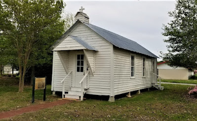
Next up over in Treutlen County, we get to our next geocache at the Old Soperton School (GC5DVA8). I spent about an hour or so researching this old schoolhouse. However I couldn't find any history on it. Maybe one of you readers can share some insight to this place.


We also stopped by a cemetery about 8 miles north of Soperton for another geocache (GC49JYF). The small well kept Ricks Family Cemetery has 72 interments according to the FindAGrave website. Daniel Ricks (1795-1878) settled in this area and opened the Blackville Mill. His son, 28 year old John Ricks, was the first to be buried in this cemetery in 1859.


Moving along into Johnson County, I stopped for a quick roadside guardrail geocache (GC2ADG3) just outside the town of Wrightsville.

A few miles north of there in Washington County, I arrived at my next geocache (GC5QVK3) with a sad story of forgotten history. According to the CO of the now archived geocache: "My dad bought this land in 1959. He passed away in 1996. My sister and I now each own part of this land. When my dad acquired the property there were remnants of markers or head stones made from coarse materials, probably a concrete-like material. A previous owner had removed the markers from the small graveyard. He plowed and planted over the area. No one knew the actual location of the graves. The story has been passed down that it was a small area of graves .No bones or materials have ever been found. As the older generation has passed on, the younger people here do not know that this ever existed. While there is no way to ever know more about this, we can still remember them." Only thing there now is this cross next to a pine tree.


Still in Washington County just a mile or two away, was this really creative geocache container (GC5QN7X) at the corner near the entrance of the owners ranch.


Further north just past the town of Gibson, We stopped for one more quick roadside guardrail geocache for Glascock County (GC3DA5F).

Now it's early evening and time for us to grab some dinner and find a hotel. We made it about halfway back to the RV Park in NC. See you back tomorrow to finish the roadtrip.

To follow along on our travels and keep up with my latest blogs, you may do so here of course. But also by using you favorite of these social media platforms: FacebookMeWeGabRedditParlorTwitterRVillageGETTR and Instagram. These all link directly to my profile. Again, please feel free to comment and / or share.

Saturday, September 18, 2021

2020-03-28: Roadtrip Day 2: Driving Through Louisiana and into Mississippi on the way to Georgia

One thing I like about driving the backroads and byways on a roadtrip is that you never know what you're gonna see around the next corner. Whether it be a scenic overlook, a piece of history, or just something so crazy funny that it requires you to turn around for another look and capture it with a photo. Todays drive had something for everyone. So there's a lot to see now let's get rolling...


After waking up early in Shreveport, Louisiana and going for breakfast, I grabbed a quick urban geocache that was close by (GC7G3XD).

On the way to my next geocache, I passed this old church building. The sign out front said Antioch Baptist Church. It doesn't look like this facility has been used in many years. In preparing to write this blog post, I spent a few hours trying to research some history but kept coming up empty. I can't find anything on this old church.


So I arrive at the next geocache (GC1XVN5) which was just a simple and quick roadside cache to add a new county into the finds list. Upon arriving though and seeing the sign, I guess they take their "No Trespassing" pretty serious! I found the cache quick and got myself outta there!


After another quick roadside geocache (GC7QJ0X), I passed by these two old abandoned houses that were just slowly decaying and falling apart. I'm always curious as to what happened with these homes...


...especially this second house. It looked like it would have been a house to envy back in the day. Come to find out that it is called the Garland House. It was built in 1902 and placed on the National Register in 1994. It is a Queen Anne Revival design. This one is in great need of reviving.


Continuing eastbound on Hwy 2, the next geocache was at the Corney Creek Calaboose (GC26WWQ). A calaboose is a tiny jail. This calaboose in the town of Bernice, LA was built in 1902. The town of Bernice was established in 1899 as a sawmill town after Captain C.C. Henderson built the Arkansas Southern Railroad.


This next stop was rather sad. On the north side of Bernice is the old Mount Olive Cemetery (GC26HGV). This neglected forgotten cemetery contains between 40-50 burials dating as far back as 1860. However, I only saw less than 10 headstones in all this overgrowth. Some of the locals need to come out here and clean this cemetery up.


Still following State Highway 2 eastbound to pickup caches in these northern parishes, my next stop is an earthcache and a traditional cache at Elgin Springs (GC20PEP, GCJ4CV). It would have been a quick roadside stop, but I had trouble finding the traditional cache and had to DNF it. As for the earthcache, I got what I needed to answer the questions to log a find. No photos here since it really isn't much to see here. Not exactly what you picture in your mind when you think of natural springs.

To make up for the lack of photos at the springs, I was able to capture two great old car pics as an unexpected surprise. This one below of a 1920's sedan just rusting away among the trees along the highway. And the more humorous one I opened with at the top of the page.


These next two were just quick roadside park and grabs (GC73X26, GC23FEX).

Our next stop was a really cool piece of history in Oak Grove, LA. The Fiske Theatre (GC29ZM9) was first opened in April 1928 and at that time was the premier state of the art movie cinemas in Northeast Louisiana. It was owned and operated by the late Donald Fiske of Oak Grove. The Fiske Theatre was a two level cinema with a first floor that seated 500 people and a balcony that seats 250, as well as a cry room located on the back of the first floor for mothers with small children.

The Fiske Theatre was rebuilt in 1950 and relocated from just down main street to it's current location, and was operated continuously by the Fiske Family until 1987 as a first run cinema. It looks just about the same now as it did in the 1950's. In 1987 as Mr. Fiske's health began to fail him, the theatre was donated to the West Carroll Chamber of Commerce where it has been used mainly for gospel music concerts and other community events since then.


The theatre is in very good condition thanks to the hard work of the chamber volunteers and numerous grants for upkeep from the Louisiana State Legislature. After a two-month renovation period in the fall of 2008, the Fiske Theatre returned as a first run movie theatre on December 15, 2008 with a showing of "Fireproof". The theater is run by volunteers who share a passion for the preservation of this historic movie theater. Any proceeds go to the upkeep of this terrific piece of Americana. At the time of our visit to the Fiske Theatre was closed as the pandemic was just beginning to spread.

Next up was a geocache at the Cotton Museum (GC1CN8D). The Louisiana State Cotton Museum in Lake Providence provides a great introduction to one of Louisiana’s major agricultural crops, and certainly the one for which the Delta area is best known. Its main gallery features an extensive set of interpretive exhibits, including life-sized dioramas, farming equipment, a re-created juke joint and more, all packed into a replica gin house (where cotton fiber was ginned, or separated from the seed).


Also on the grounds of the museum is an impressive array of old plantation buildings, such as a sharecropper’s cabin, a schoolhouse, and a small chapel. And of course an old outhouse where the cache was hidden inside the business deposit area.


One more quick roadside geocache in the town of Transylvania (GC1CN8Z) along with the above museum are two caches for the East Carroll Parish completing the northern counties in Louisiana.


Now we face the Mississippi River and need to cross over. Most would go south to I-20 and cross over into Vicksburg. Been there, done that, and already have those counties. So I turn north into Arkansas. I stop for two quick geocaches along US-65 for Chicot County (GC2QTFTGC2R0NT). Then took US-278 to cross the great river.

Passing through Greenville, Mississippi, I spotted this riverboat and stopped for a quick photo.


The next few stops were part of the Mississippi Blues Trail. In the small town of Holly Ridge you'll find the final resting place of three bluesmen (GC15CJ1). Charley Patton (1891 - 1934) was the most influencing figure in the pioneering era of the Delta Blues. He helped define not only the musical genre but also the image and lifestyle of the rambling Mississippi bluesman. He roamed the Delta using Dockery as his most recent base, and lived his final year in Holly Ridge. Patton and blues singers Willie James Foster (1921 - 2000) and Asie Payton (1937 - 1997) are buried in the Holly Ridge Cemetery.

In the next town of Indianola, MS, I found the B.B. King Corner (GC4MZKG). It was on this corner, when Riley B. King was just a young man of 17, that locals first heard the musician destined to become the "King of the Blues." On June 6, 1980, BB King placed his handprints and signature here in the sidewalk to the left of the guitar.


Our last geocache of the day was at the Indianola City Cemetery (GC30XD5). This is a large well maintained cemetery with over 3,000 interments.


We ended the day in Greenwood, MS, a little more than 300 miles after we started. I picked up some new counties and parishes to fill the map. And we saw a lot of great roadside attractions, planned and a few surprises too. Tomorrow is another day and we still have a long way to go and a lot to see. I hope you come back and join us. See ya next time...

To follow along on our travels and keep up with my latest blogs, you may do so here of course. But also by using you favorite of these social media platforms: FacebookMeWeGabRedditParlorTwitter, and Instagram. These all link directly to my profile. Again, please feel free to comment and / or share.

Saturday, May 15, 2021

Exploring the History of Gilliland, Texas and is it a Ghost Town

Hello and welcome back to another edition of AwayWeGo's Geocaching Adventures. This is one of those blog posts that is a little different than my usual roadtrip stories. After leaving North Carolina, my next construction project brought me to this little town of Gilliland, Texas. For the two months I was here, I got to explore some of the area and take a look into Gilliland's past through some of the abandoned buildings. 

I don't know if I would call this a ghost town or not since at best it reached 120 residents at one time. Now it's down to just 25. But with some of the creepy abandoned buildings, I'll let you decide.

An old abandoned farm house.

There were no Geocaches here for me to find, but I did manage to hide a few myself to bring other Geocachers to this small community to discover what I've found.

Gilliland is located on Farm Road 1756 some seventy miles southwest of Wichita Falls in north central Knox County. The first Anglo-Saxon to arrive to this area was probably was a surveyor (like myself) named Captain Randolph B. Marcy who was commissioned to look for a suitable site for a wild Indian reservation. In 1870 Indians were making forays taking food or spoils or just pillaging. In 1871 the first settlers, who began arriving in covered wagons seeking new opportunities, called the community Coyote on the land between the north and south forks of the Wichita River. Wagon trains brought families who lived in tents, two room picket houses, wagons, and half-dugouts. 

Settlement came in waves by men mostly of European culture until the arrival of a nearby railroad which paved the way for a population explosion. Over the years the area gained a mix of settlers from various locations, including several Norwegian families from Bosque County, who arrived in 1890. Stores, homes, churches and schools sprang up to provide the settlers needs.

The Gilliland school district was established on May 1, 1892, and school began in 1895 with Miss Oma Acker as the first teacher. Over the years several schools were consolidated with the Gilliland district after the now abandoned school building (GC8AN63) was erected in the 1930's. Gilliland's new school featured numerous classrooms, a cafeteria, and a gymnasium that doubled as an auditorium for plays and assemblies. In 1948 its high school was transferred to Munday, leaving Gilliland with only a grade school. It continued until finally closing its doors in 1975.

The Abandoned Gilliland School Gymnasium / Auditorium

District judge W. A. Gilliland became the town’s namesake when the opening of a post office in 1907 required an official name. In 1910 Luther Burgess, Jake Cure, and W. A. Cure built a cotton gin just outside of Gilliland. The gin was modernized in 1936 and proved to be highly productive. Leading settlers included O. M. Olson, who operated a post office in his home in 1907; F. B. McGuire, owner of McGuire's General Store; and longtime postmaster J. S. Cook, owner of three businesses between 1926 and 1934.

Gilliland had an estimated population of fifty in 1925. By 1947 it reported 120 residents and four businesses. In 1971 it had three businesses, and from 1971 to 1990 its population was reported as 103. By 2000 the population had dropped to twenty-five.

Today the community consists of the ruins of the 1930 school, grain silos and a few former businesses being reclaimed by nature – although the community center is in good repair and still in use for meetings and a voter polling place.

The Gilliland Cemetery (GC8AN86) is a well kept still in use cemetery with over 330 interments to date. The one grave that stuck out here is for a man named Liberty Justice who died in 1925. I tried researching this man for a few hours but didn't come up with anything but his spouse and children's names.


So while working here in Gilliland, I'll be living about 20 miles south in the town of Munday. Over the next few weeks I'll be bringing you stories about of my weekend roadtrips between here and Killeen and all the places I've discovered in between.

I leave you with a few more photos from Gilliland:

The Abandoned Gilliland School Gymnasium / Auditorium

Swing-set behind the school and abandoned house.

East-West Hallway of Abandoned School

Front Entrance of Abandoned Gilliland School

Front of Abandoned Gilliland School
You can get a look of the walled entrance which prevented cows from wandering inside.

Abandoned gas station with Esso gas pumps.

Abandoned General Store

Abandoned Former Store or Garage?


Side Door of Abandoned Gilliland School

Abandoned Farm House

Abandoned Old Ford Trucks left in field.


Inside Abandoned Farm House

Abandoned Farm House

Abandoned gas station with Esso gas pumps.

Hwy 267 going south to Munday

Sunday, March 21, 2021

2019-06-02: Geocaching Through Love, History, and Chainsaw Art Along the Backroads of Virginia and North Carolina.

Who's up for a surprise road trip? Well one of my co-workers on this project here in North Carolina got transferred to another project up in Virginia. And he doesn't have a car to drive there himself. So I offered to drive him up there myself. That's also another roadtrip opportunity to go Geocaching in a new area, to see new things, and maybe get some new caching county or two out of it. So off we go...

His new project was just outside the town of Blackstone, Virginia. Doing some research online, we found a place for him to rent while he's there. So a quick stop at Hardee's in Washington, NC for breakfast and we hit the road. We drove straight up into Virginia and arrived at the rental house, but the person renting out the room wasn't home at this time. Instead of just waiting there for an unknown amount of time, I drove him up to Enterprise over in Colonial Heights so he could rent a car until arranging a ride with another co-worker.

Now that his transportation is set and he's heading back to Blackstone, I'm going south back to North Carolina. But not before finding a geocache (GC6J8B2) right there in the parking lot next door. Now one thing a little different with Virginia is that they have 95 counties to find caches in. But then there's also 38 independent cities separated from the county borders for a total of 133 regions to complete on the "county" map. This cache gave me credit for the city of Colonial Heights.

Then I drove over to the "Welcome to Hopewell" cache (GC3X2VT) to get credit for the City of Hopewell region. There along with the normal "Welcome to" sign, they have a huge "LOVE" sign.


A quick roadside stop in the City of Petersburg (GC2JQCN), and another in Nottoway County (GC27HQ8). Then over in Prince Edward County at the Gallion Game Sanctuary, I picked up a couple of caches down some Jeep trails (GC4MNAM, GC4MN9X). In Charlotte County I realized I skipped right over lunch when my stomach started growling. I hit the drive through at a Burger King then parked next door in the parking lot of the Food Lion right next to the LPC cache (GC5XD7R). The last geocache today in Virginia was for Mecklenburg County (GC2W7HB).

On the way out of Virginia, I passed this place called Chainsaw Art. Seeing some of the work on display I knew I just had to pull over at this roadside attraction and get a close-up look. If this is the stuff left outside on a Sunday afternoon when nobody's around, the artwork on the inside must be amazing. I don't usually include this many photos for one place. However I thought this place deserved it.


Stopping for gas in the tiny town of Wise, North Carolina, I spot this old abandoned red brick two-story building. I asked this guy sitting on a chair outside the Pay Jay's Corner Store if he knew anything about it. He just said it was the old school building. Now doing further research, I find that this old abandoned school building was built in 1904 and was placed on the National Register of Historic Places in 2006. I'm not sure when it was last used. There is an effort underway to raise funds to restore this old historic school building.


My last stop of the day was a virtual geocache (GCH16M) in Littleton, NC. Here you'll find a replica of the home of Nathanial Macon and the gravesite of he and his wife. The original house burned down in 1977. From the headstone: "Nathanial Macon, born December 17, 1758, was a soldier of the American Revolution, a state senator in 1782 and 1784, a Representative in Congress 1791-1815, Speaker of the House 1801-1807, United States Senator from 1815-1828, President of the Constitutional Convention of 1835, the strictest of our models of Republicanism." Notice they did NOT use the word democracy which is so misused today. The founders despised democracy and mob rule, forming a Constitutional Republic.


Nathanial Macon was one of the most powerful men in the nation and exercised great influence until his death June 29, 1837. Thomas Jefferson referred to Macon as "The Last of the Romans."


Nearly 500 miles later, I finally returned back to Blounts Creek, NC. It was one of those unexpected but pleasant geocaching trips, picking up some new counties and seeing history. Now time to get some rest and prepare for work tomorrow. Thanks for stopping by and look forward to having you ride along again soon.