Showing posts with label virtual. Show all posts

Saturday, September 16, 2023

2021-06-17: Summer Road Trip to Buy Our "New-to-Us" Home and Geocaching Through Texas, Arkansas and Missouri

Hello Friends! Well some of our regular readers may recall that the primary reason that we are able to go on so many geocaching roadtrip adventures is because we work in construction. We travel from project to project across the country and had to find short term rentals in each town to live in while there working. My wife has been traveling and working with me for about two years now, though this last solar project we just completed near Fort Stockton, Texas she didn't work on it.

When we arrived in the nearby small town of McCamey at the beginning, the choices for rental accommodations were old rundown houses from the 1940's. My wife took one look and decided she'd stay with her daughter in Killeen, TX for the duration. Now that it has completed, I have three weeks before starting at the next location in North Texas. So what to do but go on a roadtrip to Indiana where I found our "new to us" home to buy! Finally after a year of looking... a wish comes true!


My last day on the project was a Tuesday. I had packed up everything in the Jeep that morning and I made the 5-hour drive to Killeen after work that evening. On Wednesday, Candy and I packed as much as we could into our little 2-door Jeep for us as well as her teenage grand-daughter who rode along with us on this roadtrip adventure.

So we left Central Texas and our first stop wasn't until Texarkana, Arkansas or is it Texas? Or Arkansas? Actually it IS in both! The courthouse sits right on the state line. Now that's a divided court and was a virtual geocache, now archived (GC829D).


After 450 miles of driving, we stopped at a hotel in South Hot Springs, Arkansas for the night. Waking up Thursday morning and checking out, we grabbed a quick geocache (GC1KGXN) right there in the parking lot before hitting the road.

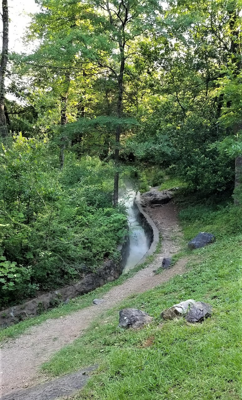
But not before taking a quick drive into the historical Hot Springs National Park and Bathhouse Row. Hot Springs, Arkansas, gets its name from the naturally 143 °F thermal spring waters found here. Flowing out of the ground at almost one million gallons of water each day. Native Americans called this area “the Valley of the Vapors,” and it was said to have been a neutral territory where all tribes could enjoy its healing waters in peace. Spanish and French settlers claimed the area in the mid-1500s. In fact, famous explorer Hernando de Soto was the first European to visit Hot Springs in 1541.

While it is true that President Grant designated Yellowstone as the first "National Park" in 1872, it can also be said that Hot Springs, Arkansas was technically the first national park when President Andrew Jackson designated Hot Springs a "Federal Reservation" in 1832 for public use. Hot Springs didn't officially become a National Park until 1921.


Bathhouse Row has evolved over the years from it's rustic beginnings to the modern spas of today. In the 1830's, Hot Springs earliest facilities were make shift shelters perches over individual springs. Later elaborate Victorian bathhouses flourished along the avenue. But those wooden structures were susceptible to rot and devastating fires. The present mix of Spanish Mission to neoclassical architecture date from 1911 to 1939, the Golden Age of bathing.


Medicinal bathing peaked in 1946 and many of the traditional bathhouses have closed or converted into the modern spas. Traditional bathing remains at the Buckstaff Bathhouse. The National Park Service has landscaped many of the exercise paths that were considered essential to good health. Like earlier visitors, you can still stroll the brick Grand Promenade behind Bathhouse Row or hike mountain trails throughout the National Park.


Walking among the shops there on the row, I spotted an iconic Zoltar fortune teller machine made famous from the 1988 movie "Big" starring Tom Hanks. Hmmm, what should I wish for?


Also spotted this restored antique Harley-Davidson motorcycle. Not sure about those white tires though!


And then there's this statue standing outside of Diablos Tacos and Mezcal restaurant. Still too early for lunch so just took a photo.


While walking down Bathhouse Row, we did find three geocaches and completed an Adventure Lab. Along with what I've already shared with you, they also highlighted Hot Springs history with Babe Ruth and baseball (GC2ZDMJ), the cemetery (GC3JFJ9, GC92RGD), and Al Capone and organized crime in the 1930's.

Time to get back on the highway heading north. Since I've already gotten the geocached counties along the way from previous trips, I tried to make up some time and skipped a lot of the geocaches I had picked out. Got back to I-30 into Little Rock to US-67 towards the northwest.

When we get to the town of Walnut Ridge, I make a right turn onto US-412 eastbound. It didn't take long before I thought it was a big mistake. CONSTRUCTION TRAFFIC!! My next target cache was still over 40 miles. While waiting for the lane to open back up to proceed, I thought I'd check the nearby geocaches. What do I see but a new geocache hidden on my birthday (June 11), published on the 13th, and STILL yet to be found four days later! I guess it was just waiting for us to pass by! I knew exactly what it was just from name "Dollar Skirt" (GC9CMGQ). Found and stamped the blank log sheet! WOHOO a First-to-Find! Thanks for construction traffic!

Then we crossed over into Dunklin County, Missouri and made a quick roadside geocaching stop for the county (GC3ABN5). Next door in Pemiscot County we found a very large geocache with a LOT of favorite points (GC1REX7) to complete the "heal" of Missouri.

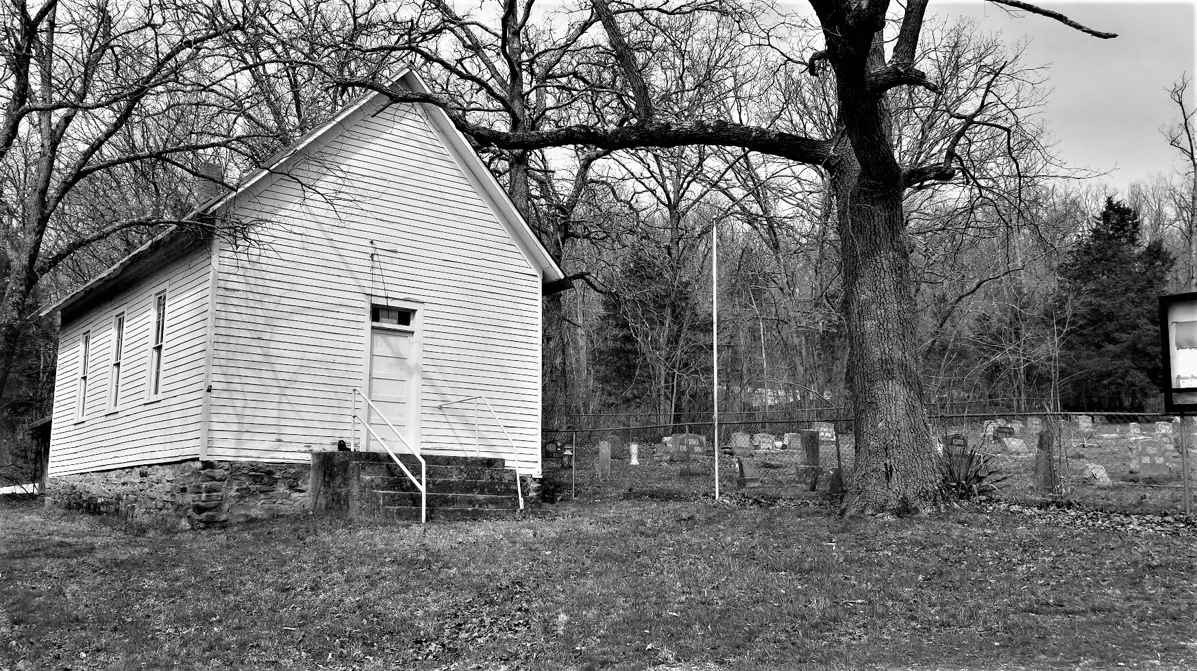
Also in the town of Hayti was this restored one-room schoolhouse. The Hayti school building was built in 1874 and was used until 1895. There was a geocache there too but we couldn't find it, as well as several previous geocachers too. It has since been archived.


Jumping onto I-55 northbound a few miles into New Madrid County, we soon exit into the town of New Madrid, Missouri. There were three geocaches on my to-do list in town to be found. The first one was at the Byrne-Howard Cemetery (GC2M4Q4). The cemetery was established in 1833 with the burial of Morgan Byrne. He was joined by his wife Jane just two years later. This small cemetery has acquired 29 permanent residents between 1933 and 1947.


We also stopped by the Hunter-Dawson State Historical Site (GC47ZVN). William and Amanda Hunter owned a successful dry goods business in New Madrid as well as a floating store selling goods up and down the Mississippi River. They built their antebellum mansion with Georgian, Greek Revival and Italianate features popular during the period. The mansion took nearly a year to build and was completed in May of 1860. Unfortunately William died in 1859 before the house was completed.


In 1874 Ella, the Hunter's youngest daughter, married William Dawson. Upon Amanda's death in 1876 Ella and William moved into the mansion. Dawson served three terms in the Missouri State Legislature. In 1884 he was elected to the US House of Representatives. In addition, he served on the planning committee of the 1898 World's Fair in Chicago.

The home did suffer damage during the Great Flood of 1937. (There is a spot in the house where you can see the water mark on the wall.) Descendants of the Hunter family occupied the home until 1958. In 1966 it was purchased by the city of New Madrid. A year later the city donated the site to the state to use as a state historic site. The home now stands as a testimony to the grand lifestyle of the successful businessman prior to the Civil War.

Speaking of the Civil War, while the Union troops occupied New Madrid, the Confederates controlled passage of the Mississippi River just around the bend upstream on a large island in the middle of the river. This prevented supplies from reaching New Madrid or any Union troops further south. In March of 1862, Colonel Josiah Bissell, commanding the "Engineer Regiment of the West," surveyed land north and east of New Madrid. Bissell found swamps and bottomland inundated with early spring floodwaters and suggested to Brigadier General John Pope cutting a canal from north of the island going west into New Madrid allowing steamboats and other ships to bypass the Confederate forces. Pictured below is a submergible saw used to cut down trees below the waterline allowing boats to maneuver through the thick swamps.


Island #10 in the Mississippi River

Backing up a bit for earlier history, New Madrid was the first American town in Missouri. Founded in 1789 by George Morgan, Princeton graduate and Indian trader, on the site of Francois and Joseph Le Sieur's trading settlement. Named for Madrid, Spain, the town was to be an American colony. Morgan was promised 15 million acres by the Spanish ambassador, eager to stop U.S. expansion with large land grants. In 1800, Spain traded the territory back to France in the Third Treaty of San Ildefonso. After trying to regain control of Saint-Domingue (the present Haiti), where a slave rebellion was underway, Napoleon gave up on his North American colonies, agreeing to sell this territory to the United States in 1803 as part of the Louisiana Purchase.


And finally, the New Madrid Earthquake (GC1DRVR), made up of a series of monstrous and lessor shocks, which began December 16, 1811, and continued for over a year. One of the great earthquakes of the world because of severity and length it caused little loss of life in a thinly settled region. Some of the shocks were felt as far of 1100 miles.


So that's it for today. Tomorrow we see a little more of Missouri before getting into Illinois and Indiana.

To follow along on our travels and keep up with my latest blogs, you may do so here of course by clicking the "Follow" button to the right. And there's also my main website at AwayWeGo.US for the complete index of my traveling adventures going back to 2005. But also by using one or more of your favorite of these social media platforms: FacebookMeWeGabRedditTwitterGETTRInstagram, and TruthSocial. These all link directly to my profiles. Again, please feel free to comment and / or share.

Sunday, July 23, 2023

2021-05-29: A Weekend Roadtrip up to Oklahoma's Ouachita National Forest and the Talimena National Scenic Byway

Well we had a 3-day weekend, so I decided another quick geocaching roadtrip in the GeoJeep was just what we needed. After a little research I discovered the Talimena National Scenic Byway located up in southeast Oklahoma and the Ouachita National Forest.  There's geocaching, offroad Jeep trails, and lots of scenic views. So we drove up from Central Texas yesterday and today we went for a drive. Follow along as we explore what I called the "Blue Ridge Parkway" of the mid-west...


Starting out in the town of McAlester in Pittsburg County, our first geocache was at the Oakhill Cemetery (GC3Q1R1). There were well over 16,000 burials here dating back to 1863. East of town, closer to Richville, is the Carbon Cemetery (GC425CH). This one is a bit smaller with less than 200 internments and even fewer remaining headstones.


Taking the rural backroads of Highway 1 into Latimer County, we soon encounter the Higgins Hitching Post geocache (GC6N344) and two more at the Mountain Station Cemetery (GC74MF4, GC77XHN). These were near the Overland-Butterfield Stage Route. The cemetery's earliest grave dates back to 1859. Andrew Mackey was killed in a stage coach wreck on a return from a California gold field.

Passing by Buffalo Mountain, we drove up to the top for our next geocache (GC3D0EJ). I didn't find the cache cause I wasn't up for bushwhacking at the time. But it was well worth the drive up as this is a spot used frequently by hang gliders and the views are spectacular.


At the western end of the Talimena National Scenic Byway is the former Welcome Center. It was recently closed due to budgetary cutbacks. Peaking through the windows it looks as though it had only been closed for a few  minutes. Everything is still in it's place. So I found the geocache (GC8JVDN) and we were on our way.


The Talimena Scenic Byway is a 54 mile drive through the Ouachita National Forest from Talihina, Oklahoma (OK-1) to Mena, Arkansas (AR-88). Let's begin the drive and take on the scenic vistas.


It didn't take long to get to the first roadside pull-off and geocache at the Choctaw Vista (GC1GNDE). A few people parked and taking in the scenery. Lucky for us none were interested in the ammo can geocache in the woods.

A few hundred feet and across the highway is parking for the Choctaw National Trail and another geocache with a bit of historical value (GCVKB6). After a short 0.2 mile hike from the parking area, I got about as good a photo as I can get of this nearly 200 year old road, abandoned, forgotten, and being reclaimed by nature. The Fort Smith to Fort Towson Military Road was constructed by hand in 1832 by the U.S. Army under the command of Capt John Stuart of the 7th Infantry. It extends over 130 miles of rugged terrain through the Choctaw Nation.


The road was originally used to relocate the Choctaw people to their new home in Indian Territory and to move supplies and troops between Fort Towson in Oklahoma and Fort Smith in Arkansas. Robert E. Lee, General Zachary Taylor, Ulysses S. Grant, and other famous figures used the road. Travelers from Poteau, Wister and Talihina used the road until about 1930.

Our new roadside scenic view was at the Holson Valley Vista. Snapped some more photos and grabbed another geocache (GCXA75).


Next was the Panorama Vista, though with so many people at this stop I just wandered into the woods and grabbed the geocache (GCVKAG).

Soon after though there was another scenic vista and we once again stopped to view it. One legend has it that Deadman Vista got its name from many years ago when horse thieves were caught on a nearby trail. With justice swift back in those days, the thieves were hung from an oak tree in a nearby gap. Here's Candy taking pics at the scene and reading the historical markers.


This wasn't one of the scenic vista's, but after passing through here, I just had to have a photo. Drove a few miles to a spot I could make a u-turn. Then passed through again until I could find another spot for another u-turn. Then, safely parking off the road, I proceeded to take several photos. Oh, if only I still had my Corvette and traffic blocked for miles at both ends!


Upon reaching the north/south road of US259, we took a little side trip to the south. I like finding old abandoned sections of roads and bridges. And this "Lost Highway" geocache brought me right to one (GC34XWB). Safely pulling off onto the shoulder of US259 and taking a short hike along the old road alignment I found the old single lane bridge which crossed Big Cedar Creek almost completely reclaimed by nature.


A few miles further down US259 is the Pipe Springs geocache (GC40Z2M). Pipe Springs dates back to the 1920's when the Oklahoma-Rich Mountain Railroad built a fifteen mile spur from Page, Oklahoma to the new sawmill town of Pine Valley. The railroad workers drove a pipe into the ground to get water to supply their needs. It also provided clean fresh water to the loggers on the mountain.


So now to get back to the Talimena Scenic Byway, I could have just made a u-turn and gone back north on US259 and re-see what we just saw. Nope, we got to keep moving forward and discovering new things. Plus we got the GeoJeep! Right next to the pipe spring was this 2-track Jeep trail going east and reconnecting to Talimena. I can never remember to turn on the video for the entire trails,  but here's a short clip:


Back on the scenic byway, we make our way over to our next virtual geocache at the Kerr Nature Center (GCH896). But it was closed.

Moving right along down to the Sunset Point Vista. At this scenic view parking area there were two earthcaches (GC3R2NE, GCZ8ZT) and a traditional geocache (GC2JRG5). The earthcaches focused on the folds of the earth and the glaciers that were in this region. The traditional was a short hike up the hill where I took this photo looking back at the GeoJeep.


So the plan was to drive all the way across the Scenic Byway over to Mena, Arkansas. But it is already nearing 5:00 PM and we haven't even reached the Oklahoma-Arkansas State Line yet. After too more geocaches at the Kiamichi Valley Vista (GCTXYH) and Chaha Vista (GC8HT2Z), I decide that it's best to go ahead and backtrack to US259 heading south.

We arrive at the Three Sticks Monument virtual geocache (GC69F2). The dedication sign at Three Sticks says they symbolize land, wood and water. It recognizes U.S. Sen. Robert S. Kerr, U.S. Sen. Mike Monroney, U.S. Rep. Carl Albert, Gov. Raymond Gary and R.G. Miller for their contributions to conservation in southeastern Oklahoma. It's too bad the vandals have to put their graffiti all over it.


On the way to Three Sticks, we passed by this other monument so we backtracked to see what it was. Turns out there was also a geocache there too (GC20VE3). On Oct. 29, 1961, President John F. Kennedy and his entourage traveled to southeastern Oklahoma to dedicate a highway. US259 was a much-needed north-south thoroughfare, opening up that part of the state for commerce and tourism. It was an astounding moment in history; the president of the United States on hand for an Oklahoma highway dedication. The State of Oklahoma and the Knights of Columbus marked the occasion with this granite stone.


One final geocache (GC3DZWV) stop before making the trek back to civilization in search of dinner! Lenox Mission School established in 1853 by Dr. Simon L. Hobbs and wife as part of the Presbyterian Church mission. This is the site of the mission. The marker on the highway says that they started with 48 students. Nothing remains except for a small, fenced cemetery. Dr. and Mrs. Hobbs are buried in this cemetery.


That's our journey across most of the Talimena National Scenic Byway. I hope you enjoyed it and perhaps added it to your "To-Do" list the next time you're in SE Oklahoma.

To follow along on our travels and keep up with my latest blogs, you may do so here of course by clicking the "Follow" button to the right. And there's also my main website at AwayWeGo.US for the complete index of my traveling adventures going back to 2005. But also by using one or more of your favorite of these social media platforms: FacebookMeWeGabRedditTwitterGETTRInstagram, and TruthSocial. These all link directly to my profiles. Again, please feel free to comment and / or share.

Friday, April 7, 2023

2021-03-31: Exploring the Historic Route 66 Through Missouri on Day 9 of Our 3400 Mile Roadtrip Adventure

Winding down on Day 9 of our crazy 3400 mile geocaching and sightseeing roadtrip adventure through history, we spent the day in Missouri trying to follow the original sections of the famous Route 66 highway from St Louis to Joplin. Along the way we stopped at many of the roadside attractions that Route 66 is famous for: a super-sized rocking chair, historic gas stations, old abandoned bridges and more. Oh and let's not forget picking up new geocaching counties along the way too! So hop on board the GeoJeep and let's go for a drive...


Our first two county cache stops was in Crawford County. A travel bug hotel geocache (GCKC79) next to the Crawford County Historical Marker.

Continuing westbound on Old Route 66, we enter the town of Cuba, MO. There we spot several places that look interesting. Among them were the Missouri Hick BBQ with an old garage out building to the side. Or perhaps it was the smoker shack where they slow cooked their BBQ. Don't know but it looked pretty cool.


Next door to it is the Wagon Wheel Motel. Now listed on the National Register of Historic Places, it was built in 1935 and originally called the Wagon Wheel Cabins, Cafe, and Station. Standard Oil leased the station for one year after WWII. The cabin rooms have been upgraded and modernized while still maintaining the exterior historic charm.


A couple of other noteworthy places to stop for a photo in Cuba would be the Holy Cross Catholic Church and the Crawford County Historical Museum, both made of the same stone walls as the motel.

Just a few minutes further in the town of Fanning is our next geocache (GC1G43E). The Rockin' on Route 66 cache brings you to the Fanning US 66 Outpost and the World Famous Rocker seen at the top of this blog post. After a few photos and finding the geocache, we started to drive off.

At the same time I took a drink from my McD's iced coffee I just purchased a few miles back in Cuba. I think I only got 3 or for sips from it as it was more ICE than coffee! So I looped right around and parked back by the Outpost. We went inside to see if they had some bottled Starbucks or Dunkin coffee to pour into my cup. Yep! We ended up spending much more as we walked out with the coffee, a few novelty soda's and some homemade fudge. The proprietor was also very friendly and welcoming. I highly recommend that you be sure to take a look around inside the Outpost as well after getting your required Rocking Chair photo.


While staying on the Old Route 66 can be very interesting, it is also a slower pace and very time consuming. We still have to get to Texas for the next project before too long. Since I already had a geocache found in the next county, Phelps, I jumped back onto the parallel I-44 to quickly put some miles behind us.

Exiting back off into Pulaski County, we make a stop for our next geocache and our first ghost town in a while. "A Gathering of Hookers" geocache (GC174AZ) brings you to the only remnants of the small community that was once called Hooker, MO. Built in 1900, this church building and cemetery are the only evidence of the early pioneers. The slow curving Old Route 66 (1926-43 alignment) passed by right in front of the church. When the new and improved 4-lane US-66 was built (1943-77 alignment), it was straightened and by-passed many of these communities.


A few Route 66 curves later and we arrive at the Devil's Elbow. A small lumberjack settlement began here after the Civil War around 1870. The name derived from a tight U-shaped bend in the Big Piney River. When the lumberjacks would send their logs downstream, they often got jammed up in "a devil of an elbow," which became known as Devil's Elbow.

Also here at the Devil's Elbow are my next three geocaches (GC175JD, GC1TG2P, GC17E9W). I'm just gonna give you a brief description of my two photos below before telling you about a great web page to go look at for more. This bridge was actually built in 1923 as part of the MO-14 state road connecting the communities. Three years later it became part of the original Route 66 alignment. However with the 4-lane realignment of Route 66 in 1943, came a new bridge. This was used only for local traffic and without regular maintenance, it was eventually condemned. Route 66 enthusiasts saved, restored it in 2013, and now open for vehicular traffic once again.


Following the curve around a half-mile to higher ground you get a good look at a section of the Big Piney River where the double truss railroad bridge crosses over.


Now for more historical information and lots of old and new, before and after photos, if you really get into history like I do, take a look at this web page I found on the Devil's Elbow community. It's a quick read and along with the photos and map will give you a better understanding of the Route 66 alignments. As well as some of the businesses that came and gone, and a revealing photo of the 2017 flood.

Making my way further westbound, we arrive in the town of Waynesville, still in Pulaski County, and our next two geocaches. The "Wire Road Stop" virtual geocache (GCE7E0) brings you to an old Stagecoach Stop listed on the National Register of Historic Places. Originally built as a complex with two log cabins in the 1850's, it was later rebuilt with wood in the antebellum style. A stagecoach stop for the Burden and Woodson Stage, also a tavern, used as a hospital during the Civil War, and a hotel after the war. Later abandoned and rundown it had been condemned by the city in 1982. Local citizens got together and saved the historical building. It is now the Old Stagecoach Stop Museum.


The other geocache was at the Talbot House (GC46FPX). One of Waynesville's oldest homes, it was constructed in 1885 by the Rev Albert Washington Davis. Dr. C.A. Talbot purchased the home in 1915 and used it as a residence for his family as well as an office for his medical practice for the next 30 years. After his death in 1945, his widow then rented rooms to boarders. Today, the current owners use it as an Antiques, Collectibles, and Gift Shop business.


Moving on down the road into Laclede County and some more geocaches along the Mother Road. The Gasconade River Bridge (GC8V6TP) is next on the list. I love these old bridges. Like the Devil's Elbow Bridge, this bridge was built during the construction of Missouri's State Highway 14 a few years before Route 66. And again with the new expanded 4-lane Route 66, the lack of maintenance and repairs led to the closure and condemnation by the state in 2014. The Route 66 enthusiasts are trying to rescue and restore this bridge as well.


My next two geocaches are in Lebanon, MO. A quick stop and find for the Graffiti Tunnel (GC8AVN3).


The other geocache has over 500 favorite points and is the second largest cache that I've ever found, with the old Space Coast Geocaching Store cache in Florida being the largest. This one is called Jolly Green Giant (GC1MDCE) and is Missouri's largest ammo can.


There was just one more geocache we stopped for right before leaving the county. Nothing really to see here. But it was a Challenge cache (GC41F8V) that required you to have found a cache in at least 25 states before claiming the find. Well we've found one in 49 states, so I figured I'd stop quickly and sign the log sheet.

Another chance to make up some time as we already have Webster County, I jumped onto I-44 over to Greene County. There were two geocaches (GC2ZFAA, GC2Z72F) near the intersection of I-44 and US-65 that had some favorite points because of their creativity. They were easy to get to and easy to find. Had an interesting containers. What I liked most and wasn't even mentioned on the geocaching listing, was the historical pioneer cemetery just down the short trail.

It was the Union Campground Cemetery which was established in 1840 by the Presbyterian Church for open air camp meetings. Historical research by locals and decedents put the number of burials at around 200. However, documentation has only confirmed 84 burials.


Staying on the Interstate to get through Springfield, I took the first exit into Lawrence County to once again pick up the Old Route 66. Knowing that Route 66 was being built to the west following the old stagecoach trail, Sydney Casey purchased some property in 1925 in the small community of Spencer near Johnson Creek. There he built his businesses in a row of connected buildings, kinda like a mini shopping center. There was a gas station / garage, barber shop, cafe, and grocery store.


Strategically placed on the right just past the Johnson Creek Bridge (GC7TE1D) which was built two years earlier, Casey was open for business from the Route 66 travelers crossing the bridge. Looking west through the bridge, you can just make out his shops on the right past the Jeep. Then another 1/4 mile beyond and further up the hill was the Camp Lookout Cabins for the weary travelers looking for a break from the road.


The businesses prospered until the new Route 66 alignment a couple miles to the north bypassed this section of the original roadway in 1960. Then eventually killed any thru traffic with the construction of Interstate-44. The cabins no longer exist except for a couple of the foundations can be seen in the grass. Fortunately with the historical interest and fans of Route 66, what does remain here in Spencer has been rescued and slowly restored. Along with the geocache on the bridge, there are 4 easy multi-caches going up the hill using clues gathered from the shops (GC7RPV0, GC7RPY7, GC7RPZ0, GC7RQ04).

Passing through west into the community of Phelps, I spotted this old school building. The Phelps School was a one-room school built in 1888. Classes were held there until 1952. It was later abandoned and fell into disrepair in the 1980's. Eventually the community got together and restored it.


Entering into Jasper County and approaching the town of Carthage, we arrive at our next geocache. The Jalopy (GC4QMA6) is another example of artist Lowell Davis creations, an old car driven by a hillbilly and his hound dog.


Well that's our quick tour of Route 66 through Missouri. One day in the future, probably after retirement, we'll get to take a slower and complete roadtrip stopping in all the small communities. But it's late now and we made it to Joplin. Believe it or not we found a great Greek restaurant called Mythos. Time for a bite to eat and then get some sleep! She got the grilled chicken salad and I got the sampler platter.


To follow along on our travels and keep up with my latest blogs, you may do so here of course by clicking the "Follow" button to the right. But also by using one or more of your favorite of these social media platforms: FacebookMeWeGabRedditParlorTwitterGETTRInstagram, and TruthSocial. These all link directly to my profiles. Again, please feel free to comment and / or share.