Friday, January 29, 2016

2014-06-12: Road Trip Day #6 Pennsylvania, West Virginia, and Virginia

So this morning we're still in Western Pennsylvania, we have four days left to get back to Florida and no specific things to see or do. But I do know that it's time we must be heading south. If we just hit the Interstate, we can be back in two days. As I'm looking through Google maps trying to decide which route to take, I noticed US19 just south of Pittsburgh. US19 goes all the way down to Tampa, FL. So I decided we'll just follow US19, stay off the Interstate, and see what we'll find.

Throughout the day we managed to find 13 Geocaches at various stops along the way. Mostly during food or gas stops and nothing really to note about. We saw some small towns and scenic views of hills and mountains. For most of the day it was overcast and wet, so not many photos either.

The first place worth mentioning was this old US-19 bridge crossing over the Birch River from 1916. Located in Birch River, WV, it has long been replaced with the current 4-lane bridge that makes the US-19 highway. It's nice they kept this old piece of history in place.


Further on down the highway, we did cross over the New River Gorge Bridge in West Virginia. Even though there was a lite rain, we did stop for a quick look from the rest area. The New River Gorge has become a National Park. The bridge is the longest steel span in the western hemisphere and the third tallest in the United States. It is one of the most photographed places in West Virginia. Too bad the weather wasn't cooperating.


After crossing the border into Virginia, we got a bite to eat, found a hotel and called it a day. Thanks for following along with our adventure. See you tomorrow.

2014-06-11: Road Trip Day #5 Hiking the Rails in Pennsylvania

Today is another big day! Not only is today my birthday, but today we're setting out to get a Geocache that has been on my watchlist for a couple of years. Another example of Geocaching bringing you to some really cool places!

If you were visiting western Pennsylvania or even Pittsburgh, you probably wouldn't have any idea this place was even here. It's not a tourist area. There's no signs directing you here. So unless you're either a local or a Geocacher, you'll probably miss out on this great adventure.

Just a few miles off of I-80 near the town of Clarion, NE of Pittsburgh, remains the remnants of a bygone era. The rails and ties that run through the woods have been removed. But the tunnel and the train trestle bridge remain. High above the Clarion River is the Clarion Trestle. Only used now for hikers, adventure seekers, and probably some party goers too.

After exiting the Interstate, we drive a few miles through some winding back roads until we reach the small pull off area for parking. I grab the backpack with water and flashlights and we begin the climb up the hill to the level ground where the tracks used to lay. Its not long before we see the eerie dark hole into which we must pass through. You don't realize the size of the tunnel until you reach the entrance. It was huge. Then excitement continues to build as you look into the darkness and see the tiny light coming from the other end.


I didn't think to measure, but the tunnel must have been 500'-600' long. It was damp and cool inside. And I didn't smell or hear any bats either, so that was good. Once we pass through the tunnel, we see the trestle bridge high above the river. Also, this side of the mountain seemed a bit foggy with a lite drizzle of rain. We started to venture out over the bridge, but the wooden R/R ties seemed a little slippery and damp. So we decided to follow the path running parallel to the river to get the Geocache. It was about a half mile hike through the woods with the last 200' going up the side of the hill.


After hiking out of the woods and back to the bridge, the sun had come out and began drying things off. So we felt a little safer out on the wooden beams and we decided to go walking out further and enjoy the views from high above the river. You just can't do this on most train trestles because they're still in use. You get caught in the middle of the bridge and a train comes, you got nowhere to go. Here you can take your time and enjoy the views, the peace, and the serenity.


And now for the really spooky part. With the sun shinning, warming the air, and high humidity, the cool damp air from within the tunnel began pouring out in a fog like a flowing river. And once inside the tunnel, the fog just filled the whole thing. The first time walking through you could at least see the other end. This time you couldn't see but 20' ahead. Kinda like driving through a thick fog at night with your headlights on. When we got to the center, we turned and looked in both directions and you could not see the outside.


Continuing to press on, we finally began to see the light at the end of the tunnel and made it back to the car. Across the street was another small creek. Beyond the creek you could see that there were several cement support structures that one held the railroad tracks crossing over on that side. They were probably 25'-30' tall. There was also a Geocache atop of one of those, but we hadn't anyway of climbing to reach the top of it.

On thing I learned was to always check ahead of time, even at the last minute, for any additional caches. Down in that little valley among the back roads, I lost cell phone service. Even with Verizon! Anyway, I had only written down and programmed those 2 caches from when I first started watching them. If I would have checked again that morning, I would have noticed that there was another Geocache located right at the bridge. Just a little hike down the side of the hill to its base and we could have made it two cache finds there. Oh well... another time.

We managed a couple more simple Geocaches that afternoon, but called it an early day after the long drive yesterday and into last night.

Thursday, January 28, 2016

2014-06-10: Road Trip Day #4 New Hampshire, Vermont, New York and Pennsylvania

Day four of our 2014 summer road trip and we picked up 12 caches in New Hampshire, Vermont, and New York. One of the reasons for driving up this way was to go Geocaching in NH and VT. Now we have found Geocaches in 49 of the 50 states! The only one left is Hawaii. But that's for another adventure...

Our first stop and cache for the day was just down the road in West Burying Ground 1772, located in West Chesterfield, NH. Not much is known about this cemetery, but we did find a couple of headstones dating back to the late 1700's.


From there we continued westbound on Hwy 9 across Vermont. We grabbed a couple of quick caches during gas or food stops, but nothing worth noting. But just before we crossed the VT/NY border, we saw this huge structure sticking out above the trees and had to investigate. It turned out to be the Bennington Battle Monument. It is the tallest structure in all of Vermont and commemorates the Battle of Bennington that lead to the turning point in the Revolutionary War. Turns out there was also a Geocache hidden here as well.


OK, so here's another great story and reason for Geocaching. After leaving the monument, we crossed over the border into New York. Several miles down the road, that probably millions of people have passed by without even noticing that it's there, was a virtual Geocache. The reason was to give notice to this single headstone / monument for Mike Kane. "Killed here by unknown assassin July 26, 1930."

Further investigation by other Geocachers have found that Mike Kane was a Bennington taxi driver and was murdered along Route 7 near the Stone School House. His murderers were not caught until 1936. A Mr. Pencus and a Mr. Franco were arrested, convicted and sentenced. A Miss Mark was also arrested and charged. She turned state evidence and was not prosecuted.


Going further west, we arrive in Albany, NY, the state capital to view some of the sites and find 3 virtual Geocaches. The first was the King Memorial Fountain, designed by Scottish sculpter J. Massey Rhind. Second was the Women Veterans Memorial, followed by a geometric sculpture near the Empire State Plaza. We also took some time to walk around and admire some of the architecture in the area.


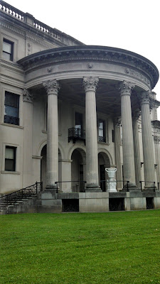
By now time was against us and it was getting late in the afternoon. I wanted to make it down into western Pennsylvania for the night, but I also wanted to make a few quick stops by some historical mansions along the Hudson River. Because it was late, we didn't have the opportunity to tour the inside. We did get to view the grounds around the outside. They were the Ogden & Ruth Livingston Mills Home, the Vanderbuilt Mansion, and the FDR mansion.


Now it was time to drive off into the sunset and into the evening to get halfway across Pennsylvania. It was a full, fun, and adventurous day, full of beauty and history! And we're only halfway in our road trip. Time for sleep! 

2014-06-09: Road Trip Day #3 Connecticut, Massachusetts, New Hampshire

On day three of our summer road trip to New England, we found 16 Geocaches in Connecticut and Massachusetts. Our first stop was this statue located in Windsor, CT. It is of Major John Mason who was born in England in the year 1600. He immigrated to the New World in 1630 and founded the towns of Windsor, Old Saybrook, and Norwick. He was the Magistrate and Chief Military Officer of the Connecticut Colony. He died in 1672. This monument was erected by the state of Connecticut in 1889. This is just another example of the great benefits of Geocaching. You learn so much history!

Across the street was the First Church, the oldest Congregational Church in Connecticut. Its beginnings trace to 1630 in Plymouth, England, where 140 men and women sailed on the Mary & John bound for the colony of Massachusetts. Hearing from the indians of the fertile land along the Connecticut River, a small contingent of settlers, including the above mentioned Major John Mason, headed southwest establishing the first Connecticut town of Windsor in 1633. In 1635 the First Church congregation ventured from the settlement in Dorchester, MA and joined the rest in Windsor, CT.

Next door to the church is the Historic Palisado Cemetery which is home to the oldest legible gravestone in Connecticut. That gravestone belongs to the Reverend Ephraim Huit who died in 1644.

Heading further north up the road along highway 159, we passed by this "Drastic Park" made from scrape metal on the side of someones front yard. After stopping for a quick photo opp, I checked my phone and lo and behold there's a Geocache located there as well! A magnetic hide-a-key located inside the mouth of one of the dinosaurs.


Just a few more miles up the road near the Bradley International Airport, was our next to Geocache stops. The first at the Connecticut Fire Academy and this memorial to the brave men and women who put their lives in danger for others. Next door was another cache at the New England Air Museum.


Crossing over into Massachusetts, we made it to our next Geocache located at the entrance to Forest Park, in south Springfield, MA. There we found what had to be a 20' totem pole carving of Omiskanoagwiak, the Wolf People Medicine Man of the Pioneer Valley Indians.


From there, we detoured a little to the east to grab another Virtual Geocache. Most geocaches have an actual container and logsheet to sign. A Virtual Geocache was allowed in the early days of caching for use where a container could not be placed. Like the above medicine man statue was a virtual. It required emailing some information requested from the plaque. But they no longer exist to create new ones and when one gets archived, it cannot be re-created. So we always look for these types and sometimes go out of our way just to find one.

The next one was in the town of East Longmeadow, settled in 1744 and known for its sandstone quarries. There we found a stature called "The Quarryman" honoring those who quarried red and brown sandstone from over 50 quarries during the 1800's.

From there we continue on I-91 north to Holyoke, MA and stopped along the Connecticut River to view the dinosaur footprints. This was the location of an Earthcache. Similar to a virtual, there's no actual logsheet to sign. You read and learn about the location and then email the required information.


A big lizard was here!
The trail leading to the dinosaur footprints.
The next stop on the list wasn't much of a photo opp, but a piece of history. The virtual cache location was a piece of land with a large boulder and plaque. The plaque reads: "This boulder stands on part of the original home lot of Moses Hutchinson, one of the first five settlers of Old Pascommuck. On May 24, 1704, Pascommuck Settlement was attacked by Indians. Of the 33 people then living in this region, 19 were killed, 8 escaped, 3 were rescued, and 3 were carried captive to Canada.

Further up the road gave us a chance to stretch our legs and do some hiking. The next several Geocaches were located within the 400 forested acres of Mt Holyoke and J.A.Skinner State Park. Upon the mountain was the Summit House built in 1851, a memorial for a WWII plane that crashed here, some great views, and even some early graffiti! Yes, there was a name and date carved on one of the boulders from 1873. This carving went undiscovered until the 1970's.


Two more stops in Old Deerfield and in Greenfield for two more virtual caches. Old Deerfield was Indian land called Pocomtuck, settled by men from Dedham in 1671. Attacked by Indians, burnt and abandoned in 1675. Reoccupied and attacked in 1704 by the French and Indians, who took 47 lives, and carried off 112 captives to Canada, of whom 60 were later redeemed.

Finally, we settled in for the night at the Riverside Hotel located right alongside the Connecticut River on the border of New Hampshire and Vermont. A beautiful view from our room overlooking the river and the end to another great day of Geocaching, adventure, hiking, and history.

The view from hotel room.

From the old bridge looking back at hotel.

Ain't she pretty!

Friday, January 22, 2016

2014-06-08: Road Trip Day #2 Virginia to Connecticut

On day two, we wake up in Southern Virginia, get some breakfast and continue on up I-95. Our first Geocaching stop was a few hours north at the Stonewall Jackson Shrine in Guinea Station, VA. Accidentally shot by one of his own men during the Civil War at The Battle of Chancellorsville. He was brought here to recover, but caught phenomenon and died a few days later.


Although Candy and I find history very interesting, the grandkids were no longer amused and just wanted to get to Maryland. We wanted to take them into Washington D.C. to show them some sites, but we too had gotten weary of their "I'm bored" comments and looked forward to dropping them off. So we looped around the beltway and dropped them off at their fathers in Westminster, MD.

After saying our goodbyes, we quickly got back on the road and headed for The Big Apple: New York City! It was Sunday afternoon now and I was hoping to view the city and be out of there that evening before all the Monday traffic.

What a great time visiting the city. We parked over by the water at Battery Park and began walking through the streets. We got to see the newly finished GZ memorials, the Freedom Tower, the Statue of Liberty, and more. Just a glimpse of the city and realizing we'll need to come back someday and spend an entire week!


That evening we hurried out of the city on up to West Haven, Connecticut for the night. Another great day in the books!