Hello again and welcome back to the AwayWeGo's Geocaching Adventure Blog. Before I get started, I just wanted to say thank you for stopping by and following along with our travels. We hope they have not only been entertaining, but informative and making you want to get out exploring and Geocaching yourself. Always feel free to share this blog with your friends and please leave your comments below. We'd love to hear from you.
Today's Geocaching Adventures took us to North Central Texas. Texas is so large you kinda have to use two directional words to narrow down the area! Kinda in the Abilene to Wichita Falls to Fort Worth triangle if you will. We had 11 unfound geocaching counties on the radar, but managed to make it to only 7 before skipping the rest and heading back to the hotel. A nearly 500 mile loop just to get those! I think we would have tried to get the others, but imagining what the puppies were destroying after 12 hours locked up in the hotel room...!? Yeah better get back!
So this morning we walked and fed the pups and putting the "Do Not Disturb" on the hotel door, don't want housekeeping to be mauled by the 6 lb Chihuahua and 3 lb Pomeranian attack dogs! We drove over to nearby Denny's for a hearty breakfast and then Starbucks for our coffee on the road. The hotel being in Abilene and Taylor County which we already have, we skipped the local caches.
Driving up US-277 north to Jones County, we arrived in a town called Anson and our first cache. The Anderson Chapel Cemetery (GC1J1X3) is about five miles west of town on US-180. The oldest known burial is from 1896 and that of Bertha C Anderson. Though there are many unknown burials with a cross or a single rock as a headstone among the 94 known internments. I couldn't find much on the history here other than a Hugh Anderson (1846-1922) donated the land for the cemetery and that the chapel had burned down at some point.
Our next cache was located within Anson, the Jones County Seat, at the larger more modern cemetery (GC16B4Q & GC13DQN). With over 6400 headstones, I didn't spend much time "browsing."
 Continuing on US-180 eastbound over into Shackelford County, our next stop was the Bud Matthews Switch (GC2PT75). In 1900, the Texas Central Railway extended a line northwest from Albany across this portion of Rose Ella (Matthews) Conrad's cattle ranch. Ella and her brother John A. "Bud" Matthews, for whom this site is named, promptly constructed cattle pens and a loading chute at this location. Surrounding ranchers soon were shipping their cattle from this switch to markets in Fort Worth. As many as 105,000 head of cattle were shipped annually until the railroad ceased operations in 1967. Since that year, local ranchers have continued to load cattle onto trucks from this site.
I didn't find the Geocache here though. There's a lot of hidden pockets and places to hide a micro cache on train cars. Over the years of caching and getting stung by wasps, I've gotten cautious about sticking my hands into places where potential critters can hang out. Especially here in Texas with the addition of scorpions, deadly spiders, and rattle snakes! And having left my gloves in my car, I just gave it a quick looking over.
 Then we arrive in Albany, Texas just a few miles to the east. Not necessarily the cache, but the town itself was one of the highlights for the day! There was a lot of history here to see. So let's start from the beginning... William Henry Ledbetter (1833-84), a native of Georgia, came to Texas in 1858 and established a salt works on Hubbard Creek (8 miles southwest) in 1862. Ledbetter withstood fierce Indians attacks before moving near Fort Griffin (15 miles north). He was elected first county judge in 1875. In the mid-1870s, Ledbetter built this picket house near the army post, using construction methods typical of this frontier region. It was moved here and restored by the city of Albany in 1953.
 Chosen county seat of Shackelford in 1874, Albany had a 43-acre townsite donated by Sheriff Henry C. Jacobs. County clerk W. R. Cruger named city for his old home, Albany, Ga. A wooden picket courthouse was erected. The post office opened August 1, 1876. By late 1877 there were 16 buildings - homes, hotels, saloons, a blacksmith shop. Merchants were T. E. Jackson and firm of Woody & Hatcher. Physicians W. T. Baird and W. M. Powell and lawyer A. A. Clarke located here. D. H. Meyer and Edgar Rye began (1879) publishing "The Albany Tomahawk". Already on the western cattle trail, city expanded as a frontier shipping point when Houston & Texas Central Railroad built a terminus here in 1881. By 1882 a church building had been erected. Music lovers organized a cornet band. In 1883 an opera hall opened, and a permanent courthouse of native stone was built. Succeeding D. R. Britt as the school principal, W. S. Dalrymple founded an adult study club, "The Chautauqua Literary and Scientific Circle". Albany had an academy, and then a college in 1898-1915. Local activities include ranching, petroleum production, small farming, and annual staging of the historical drama, "The Fort Griffin Fandangle".
 |
| Shackelford County Jail Erected 1877-78 |
 |
| T.E. Jackson Warehouse Established 1878 |
 Charles A. Hartfield purchased the lot on this site in 1881. A noted area cook, he quickly established "Charley's Restaurant," which included a bakery and boarding house. Hartfield was so successful that he planned an elegant rock structure in which to house his business. Construction began in March 1884 amid a flurry of development in the area. Scottish stonemason Patrick McDonnell, who was responsible for much of the stonework on the new courthouse, was foreman of the Hartfield worksite. The project's scope proved too grand for Hartfield's finances, however, and in September 1884 he sold the building to J.C Lynch. Financially ruined, Hartfield was found dead within a year.
Lynch sold his building in 1885 to three Albany businessmen; Max Blach, N.H. Burns, and Sam Webb. Charles Hartfield's widow, Lettie Hartfield, joined them as an equal partner and the group completed the structure, probably using Charles Hartfield's original plans. The building was occupied over time by such businesses as a grocery, a gerneral merchandise store, a bowling alley, and an auto repair shop. The Albany Masonic Lodge began meeting in the structure as early as 1893, and it became known as "The Masonic Building" to local residents. Real estate magnet L. H. Hill purchased the building in 1925, and the Masonic Lodge bought it in 1940.
Damage from nesting bats caused part of the building's limestone front to tumble into the street in 1954. The Masons took down the facade and rebuilt it with yellow brick. Sold again in 1996, the building was renovated and its facade was reconstructed to reflect its former grandeur as one of Albany's finest early structures.
 Charles Hartfield also purchased this land next door in 1882. As he began construction on the restaurant in 1884, he sold this property to Max Blach, VP of the Albany Water Company. He and partner N. H. Burns brought a system of running water to the town in 1884.
Blach began construction on this one story native stone structure also in March 1884. The building was completed in April and leased to J. R. Davis, who put it to its most infamous use. The White Elephant Saloon opened for business on May 1, 1884. Among its instantly popular features was a white elephant display which was removed from the rooftop early in the establishments heyday.The perpetrators were believed to be citizens who disapproved of the saloon's raucous business.
Despite its popularity, Davis announced his intent to close the saloon in February 1886. The Blach building soon was leased to W. M. Wigley, who operated a dry goods and furniture store on this site. Succeeding furniture businesses occupied the building for many years.
Blach's heirs sold the structure to S. C. Coffee in 1919. Coffee sold it in 1923 to T. J. Crow, who conveyed it to Albany businessman L. H. Hill in 1925. The structure was used for various purposes over the years: it was the home of the Albany News in the 1940's and was the workshop and office of a pipe organ maker in the 1950's and 60's. The Hill family maintained ownership of the edifice until 1977.
 The Lynch Building: this was Albany's first stone mercantile store. It was erected in stages, combining Greek Revival and Victorian Italianate designs. In 1878, W. H. Miller built 1-story east unit, and permitted Albany Masonic Lodge to erect a second story. Local rancher J. C. Lynch in 1881 built the 2-story west unit. The "Live and Let Live" drugstore was an early tenant. L. H. Hill and Family owned the property from 1896 through 1974. Clifton Caldwell bought the property and restored it in 1974-75.
 |
| Presbyterian Church erected 1898 |
 |
| Ford Model A truck parked in front of classic car museum. |
 |
| Restored Sinclair gas station |
 |
| Restored Gulf gas station |
After spending an hour walking around looking at the buildings and reading the historical signs, we finally decided to go after a Geocache. There were several in town but after spending too much time already, I just chose one at the volunteer fire department (GC5GDA9) and made the quick find.
Now heading north on US-283 and trying to make up some time, we made a quick cache stop for the "Sorriest Land in the County." (GCP6QE) There's nothing at the location to see, but the story about the land surrounding made it worthwhile.
On April 1, 1897 James H Nail, Sr and WI Cook paid the Holstein Family of Shackelford County, Texas the sum of $49,000 cash in hand for 27 3/4 sections of land (17,760 acres). On Christmas Day of 1899, Mr Nail wanted to buy, Matilda “Dude” Nail Cook and W.I. Cook, out. After heated discussions, the Cook’s ended by buying out Mr Nail. Angry at his sister for not selling out to him, Mr Nail boasted to everyone, “I’ve just sold Dude the sorriest piece of land in Shackelford County and she’ll be broke in a year, you can bet on it!”
As it turned out, the decision of Matilda Nail Cook not to sell out to her brother was either the wisest or the luckiest decision she ever made because in 1926 the Cook Oil Field was discovered on the southern part of the ranch. For a long period of time, the Cook Oil Field was the largest shallow oil field in the world. 79 Years later, the Cook Oil Field is still producing oil and new wells are still being successfully drilled. The discovery well was, in fact, the last roll of the dice that a group of men would make before going completely broke. As they were hauling their rig to the selected sight, it broke down. The rig could go no further unless additional money was raised for repairs. At this point, they made a field decision to drill on the spot where the rig broke down and hit a gusher!
There's more on the cache page about the Cook's supporting a children's hospital in Fort Worth, but I'll let you click the link for more information.
Further up the road was our next Geocache at Fort Griffin State Park (GC3C5PP). Again, there were several caches here but we only had time for one. In the 19th century, the U.S. government established forts along Texas' frontier to protect pioneers. By the early 1850s, Col. Jesse Stem farmed along the Clear Fork of the Brazos River, and Thomas Lambshead established his Clear Fork Farm. As others moved to the area, troops at Camp Cooper in present-day Throckmorton County, including then-Lt. Col. Robert E. Lee, provided military defense. Camp Cooper closed at the start of the Civil War in 1861.
 After the war, the U.S. Army established Camp Wilson, later renamed Fort Griffin, near this site in 1867.
Fort Griffin sat on the high ground above the river. A settlement developed between it and the water's edge. The town, known also as "The Flat," included merchants, cattlemen and their families. Its permanent populace supported a newspaper, the Fort Griffin Echo, as well as an academy, Masonic lodge and several stores and saloons. A rough element of cowboys, gamblers and renegades mixed with black and white troops to form a lawless scene. Among those attracted to the town were Doc Holliday, Wyatt Earp, Lottie Deno, Big Nose Kate, Hurricane Bill and Hurricane Minnie.
After the war, the U.S. Army established Camp Wilson, later renamed Fort Griffin, near this site in 1867.
Fort Griffin sat on the high ground above the river. A settlement developed between it and the water's edge. The town, known also as "The Flat," included merchants, cattlemen and their families. Its permanent populace supported a newspaper, the Fort Griffin Echo, as well as an academy, Masonic lodge and several stores and saloons. A rough element of cowboys, gamblers and renegades mixed with black and white troops to form a lawless scene. Among those attracted to the town were Doc Holliday, Wyatt Earp, Lottie Deno, Big Nose Kate, Hurricane Bill and Hurricane Minnie.
Unfortunately there was much more here to see, but we had many miles yet ahead of us. And an unexpected phone call was needed and even Verizon had spotty service way out here. So we needed to move on up the road. But we will be back to check out the rest of this now considered ghost town.

The next county on the list and our next two caches (GC13F33 & GC3VY6D) are located in Throckmorton County. The Texas legislature created Throckmorton County - named for pioneer doctor William E. Throckmorton - in 1858, with organization delayed until 1879. F.E. Conrad donated land for the town square and built a frame courthouse on this site. The firm of Martin, Byrne and Johnston designed this 1890-93 courthouse built by J.L. DeWees and Jacob Rath. The two-story Italianate-style building features polychromatic walls of quarried sandstone, quoins, pilasters, horizontal bands, arched doors and windows and a Mansard roof with brackets, pediments and a square cupola. A matching annex was built in 1938.
 |
| Throckmorton County Jail |
The next county and our next cache was also one of my favorite things about Geocaching. Located in the south-west corner of Baylor County lies what little remains of the ghost town of Bomarton, Texas. This once-prosperous town was named for settler W. H. Bomar. Things got off to a promising start with the arrival of the Wichita Valley Railroad in 1906. Bomarton was now connected to both Seymour and Abilene. A post office in the store of Tom McClure was established the same year. By 1910 Bomarton had had a school for three years and two churches that were constructed about the same time.
Two cotton gins were soon added to the town's list of businesses and Bomarton had an innovative public grazing area dairy cattle.
From a population of 580 in 1920, Bomarton reached its high-water mark in 1930 with 600 Bomartonites. The town sailed through the Great Depression with a decline of only 2 people. But the town wasn't so lucky after WWII when it dropped dramatically. By 1960 it was already down to 150 and twenty years later there were only 27 people calling the place home. The 1990 figure was given as 23 and was used again on the 2004 map.
 The St. John Catholic Church (GC10WK6) of Bomarton was established in 1908, when services and masses were held in Mary's Creek Schoolhouse or in the home of Matt Marak. The first church edifice was built in 1909, with John Cocek, Matt Marak, Leopold Skrehot, and Alois Sykora, trustees. Father Paul Mosler was installed as the first pastor in 1910. The brick building you see here was built in 1936 and is one of the few remaining buildings.


One more quick cache (GC2F6NX) behind a BBQ restaurant in Seymour, Texas, then off to our next county.
Arriving in Foard County and the town of Crowell, we head to the cemetery for three quick caches: GC6V1X8, GC3WH0V, and GC2FJH0. The last was rather creative as it consisted of 5 Geocaching containers inside one another until you got to the smallest at the center which contained the log sheet to sign.
From there we drove quickly east on US-70 over into Wilbarger County and another cemetery cache (GC54W3P). Upon arriving, there was a funeral service just finishing up and so we waited at the entry gate as cars were exiting. Finally we caught a break and was able to enter taking one of the paths in that wasn't being used by those leaving. We circled around to GZ which was about 100 yards from were the service was. Moments later the cache was in hand and we were on our way.
Our next county was Archer to the south-east. Driving down US-287, I should have turned south onto TX-25. However I decided to go the long wide turn south, going into Wichita Falls before heading into Archer County. At this point we both needed another Starbucks. It was either add another 20 minutes to our route and get one now, or wait the 3 hours until we make it back to Abilene!
 With fresh coffee in hand, we headed down to Archer City for our final cache (GC431MW) and final county for the day. The cache was hidden at the former Archer County Jail, now a museum. By 1909 Archer County had outgrown its original jail, a 16-foot square frame building. Construction on this larger facility was completed in September 1910. The sandstone structure was designed with living quarters for the sheriff and his family on the ground floor. The second and third floors had cells and a hanging gallows which was never used. The first prisoner held in this jail was arrested for stealing a horse. More than 8,000 prisoners were jailed here until the county opened a new facility in 1974.
With a long drive still ahead of us and thinking of the Geo-Puppies locked up in the hotel room for 12 hours, we skipped the last three counties and headed straight back to Abilene. Looking at the map later I saw we could have gotten one more along the way. But the caches and the route I had planned took us further east and we were driving to the southwest. We actually drove through the northwest corner of Young County and past by two caches. Oh well. It just means we'll be back another day!
Thanks for stopping by and until next time... Happy Caching!
 Choctaw County was the last along US-84 in Alabama and a county needed. I stopped at the Bladon Springs State Park for an Earthcache (GC3JAB8). The springs here, named after the original property owner, James Bladon, were first opened to the public as a therapeutic spa in 1838. Seven years later, state geologist and University of Alabama professor Richard T. Brumby and two colleagues from the University of Louisiana traveled to the springs to conduct a comprehensive analysis. Brumby reported his findings in a 27-page book, "An Analysis of the Bladon Springs," published in 1845. Following the report, the tourist trade increased so much that a resort was built, including a bowling alley, cabins, skating rink, and last but not least, a Georgian Revival hotel that could house 200. The resort is gone, but four springs remain, one of which is still covered by the gazebo from the resort days.
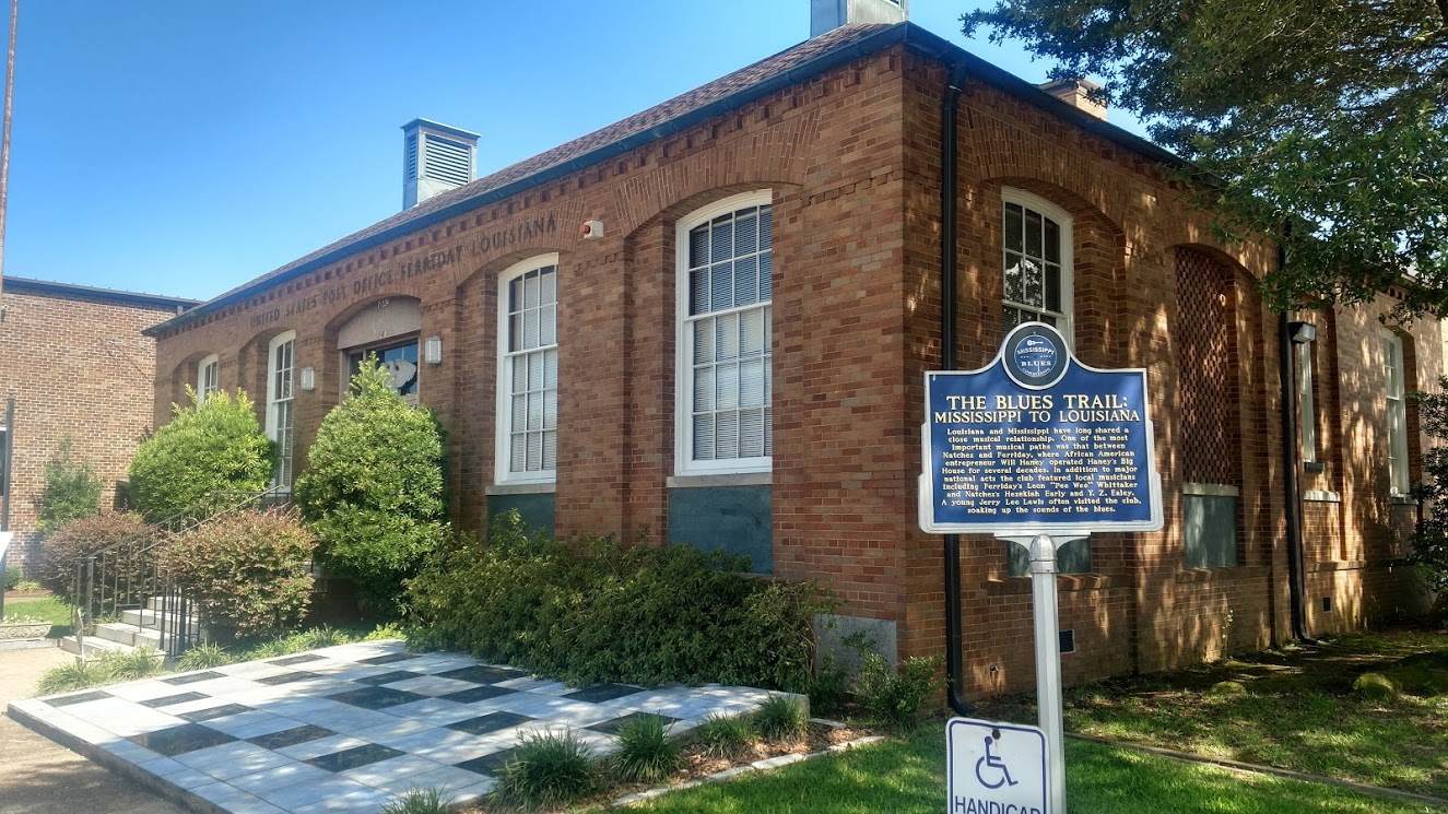 Crossing the state line into Louisiana, they have Parishes instead of counties. My first stop in Concordia Parish is the Delta Music Museum (GC1D5VZ) along the Blues Trail. Louisiana and Mississippi have long shared a close musical relationship. One of the most important musical paths was that between Natchez, MS and Ferriday, LA, where African American entrepreneur Will Haney operated Haney's Big House for several decades. In addition to major national acts the club featured local musicians including Ferriday's Leon "Pee Wee" Whittaker and Natchez's Hezekiah Early and Y. Z. Ealey. A young Jerry Lee Lewis often visited the club, soaking up the sounds of the blues.