Showing posts with label trail. Show all posts

Sunday, August 6, 2017

2017-07-01: Back in Florida for Two Weeks

Welcome back! So on Monday June 12, I finished my last day at work on Phase 1 of a solar power construction project. Spending another week hanging out in Texas, the plan was to fly to Orlando, Florida on Monday the 19th and stay there for a week seeing family and taking care of some doctors appointments. Then driving back to Texas in a U-Haul, bringing back a lot of our stuff since our stay is going on almost two years instead of the planned few months.

Well since when do things go as planned! First thing the plane was delayed a day due to weather. The flight was scheduled to leave Midland at 4:30 PM, a short stop in Dallas, then land in Orlando at 10:30 PM. Well correct that. It was first delayed a couple hours, so I still arrived at the airport, but then cancelled a day. I could have boarded a flight from Midland at 6:00 PM, to Dallas, to Los Angeles, to Charlotte, to Miami, then to Orlando at 2:30 PM the next day. If they'd have bumped me up to first class on every leg, sure. But no, so no I didn't.

So I called the hotel and the car rental and postponed my check-in. I flew out instead on Tuesday the 20th. By the time I touched down in Orlando, checked in with Enterprise Rent-A-Car, and got settled into the hotel, it was nearly midnight. And boy was I tired!

One last call to my lovely wife who had to stay behind in Texas
 and then time for sleep!

So my first day in Orlando and I'm already a day behind and I have to hit the ground running! I think I checked out of the hotel before 7AM. I've got the cardiologist at 1:00 and my sons for dinner after that. It wasn't long before I realized I was back in Orlando when I hit that traffic. I'm still down in southeast Orlando near the airport heading westbound when I spot a Walmart. That was my first stop to pickup deodorant, shampoo, toothpaste and all those essentials that I didn't want to hassle with in my carry-on luggage. Again, I hate flying.

As usual before leaving a Walmart, I check for Geocaches. There's one on the side of the parking lot. After a short search, I found the tiny cache container. However, I got nothing with me to help get the log sheet out of the container. So not being able to sign the log, I can't claim the find. Oh well, gotta move on.

Working my way west across south Orlando, I stopped by where I used to work before moving to Texas. Many of the faces have changed except for the two there working at that moment. There was a driver still around, but all the drivers had already taken off on their routes. It was good to catch up with my former coworkers. There's some customers I wouldn't mind seeing also, but I'm not going to go driving all over the state to do so.

Continuing west and heading into Ocoee, Winter Garden, and then Clermont, I spot a Jeep dealership. I still had to burn some time before my doctors appointment, so I pulled in for a quick look around. They didn't have any new ones in stock of interest, but a 2015 Wrangler Unlimited Artic Edition that was loaded with all the options. But it was this frost blue color and my preference is white. I talked to the salesman and got his card. I'd have to think about that one.

Turning north on US27, I start heading up towards the doctors in Mt Dora along the scenic route. After making the turn on Hwy 19 north and driving this country road for a few miles, I spotted this sign and got a chuckle. I just had to stop turn around and get a picture of it. Now being from Florida, I know it is the second home to a lot of snowbirds. As well as the permanent home to a lot of retirees! Well I didn't realize just how popular it REALLY was. I found the home of Dr Von Frankenstein! Florida truly is the retirement capital of the world!

A few miles further and I entered the small town of Howey-in-the-Hills, FL. Yes, there really is a town with that name in Florida. Checking my geocaching app, I noticed a couple of caches hidden since we were last here. They were on this nice boardwalk and trail leading down to Little Lake Harris. I took the short stroll, probably two miles round trip, and found both caches GC7785X & GC5QKH1.


Just around the corner from that park, I noticed a point of interest on the maps. It was the Howey Mansion and former home of the founder of this town. I'm just going to tell you of the very short version here, but I encourage you to follow this link (Howey Mansion) and read the full history and see the amazing photos of this historic mansion.

William John Howey was born on January 19, 1876 in Odin, Illinois. It was in 1908 when Howey found himself in Winter Haven, Florida where he perfected his citrus farming and sales program techniques. He believed that if he took raw land and controlled its development into mature citrus groves, he could guarantee investors a successful enterprise while making a profit on each step of citrus cultivation. In 1914, he began buying land for $8 to $10 per acre and later sold them at $800 to $2000 per acre, cleared and planted with 48 citrus trees per acre.
The Florida Land Boom tripled Howey’s enterprises and the “Town of Howey” was incorporated on May 8, 1925. In 1927, the name was officially changed to Howey-in-the-Hills to reflect the location of the town in an area of rolling hills which he dubbed “The Florida Alps”. In 1927, construction of his mansion was completed; a 20-room, 7,200 square foot mansion at the cost of $250,000, around $3.2 million after inflation. To celebrate, he hosted the entire New York Civic Opera Company of 100 artists, drawing a crowd of 15,000 arriving in 4,000 automobiles to the free outdoor performance.

Howey died of a heart attack on June 7, 1938 at the age of 62. His wife, Mary Grace Hastings, lived in the Howey mansion until her death on December 18, 1981 and was laid to rest in the family mausoleum on the mansion grounds along with William and their daughter Lois.

Arriving now in Mt Dora, I still had about an hour until the doctors appointment. I did a quick Google maps search for a Great Clips and there was one about 10 minutes away. Hopefully they wouldn't be too busy. I check in and was seated with only about a 5 minute wait. The girl cut my hair and did a fantastic job! I hadn't been able to get a decent haircut in Texas. I wish they had Great Clips out there. And I still arrived at my doctors with about 5 minutes to spare.

After two tests at the cardiologist, I'm back on my way in about an hour.

Now to drive back down to Ocoee,  about 30 minutes away, to pick up my two sons for dinner. Because of our wide variety in taste for food and the younger being a vegetarian, I decided on Golden Corral. They have a great buffet and a large selection to accommodate any palate.

After dinner my sons couldn't agree on what to do for the rest of the evening. The older, working at and being a fanatic, wanted to go to Disney to see the fireworks. The younger wanted to go to the old mall and play ping pong. Yes, there are so many empty stores in this mall that one space is rented out to this guy who has ping pong tables setup where you can play ping pong for as long as you want for just $4.00. Neither wanted to go to the movies as a compromise. But by now we are at the mall and so I made the decision to go inside.

Inside the mall, all the power is out. Even the theater has been emptied and people all standing around waiting. So the movies are a no go. We continue past and go down towards the ping pong place. And of course with no movies to watch the ping pong tables were all taken. We even passed by the bowling alley, and they were packed. So I returned them to their house and we made plans to meet again one on one so that we could do what they wanted to do.

That evening and for the rest of the time in Florida, I stayed at my mothers house up in Umatilla which is about an hour NW of Orlando. The next morning I took this photo of the male peacock all dressed up with his tail trying to impress the ladies for mating season. Just some of the many animals she has on her property.


So over the past two weeks between doctors visits and other errands around Central Florida, I did manage to find a few Geocaches here and there. Nothing real interesting, just some some basic urban caches. I did get three First-to-Finds though!

While I was there, I did spend a lot of time at the Glendale Cemetery in Umatilla. It's a half block down the street from my mothers house. The cemetery dates back to the 1880's, but most of the burials begin in the 1940's. Because Geocaching takes me to a lot of cemeteries, I also use the Find-a-Grave website for history and research. I also contribute and try to keep it up to date. After walking through the cemetery twice, I think I added about 30-35 photos to existing listings as well as added a few internment myself.

While using the Find-a-Grave website, I discovered another very small old cemetery a few miles down the road. Now I have been coming up here to visit my mother for over 15 years and never knew this other small cemetery was even here. There's not even any signage here, but it's often referred to the Old Fort Mason Cemetery. But even that is suspect because there's not much information about Fort Mason.

In a December 5, 1919 interview by one of the early pioneers of Eustis, Charles T. Smith presented some apparently accurate facts to the Lake County Citizen newspaper of May 25, 1923. When Smith and Guilford D. Clifford arrived in what would become Eustis, a few settlers were already there homesteading before 1876.

Charles Smith wrote in 1919: "Fort Mason was located about 2 1/2 miles northeast of Lake Eustis on the homestead of Warren Smith. The line of depression formed by the moat or ditch that surrounded the stockade was quite easy to follow 40 years ago." He saw the remains of the fort when he visited in 1875.

It is generally stated that the fort was built under the command of Brig. Gen. Abraham Eustis and his 1,500 troops during the 1836 Second Seminole War campaign. Little else is known about the military Fort Mason. Regulations required the commanding officer at every post submit reports, usually every month, however no records were ever found for Fort Mason. No one is really sure of what it actually looked like.

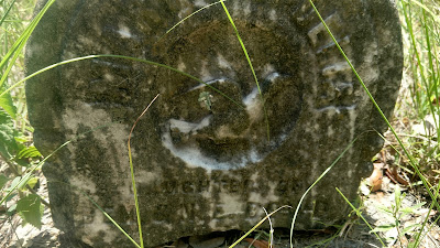
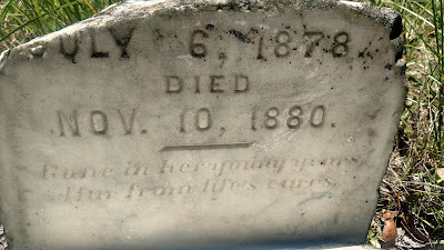
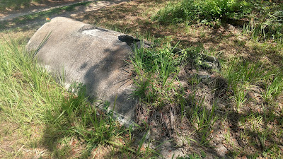
As for the nearby cemetery, all that's left is just a few headstones dating back to the 1880's. Looking at the first photo below, you can see a tall thin headstone by the oak and another smaller to the left. Further to the left is an overgrown iron fence plot with three headstones in it. Behind that is an open field with a dirt driveway along the treeline leading to that white building in the distance. About halfway back under the trees are a couple more headstones and all that remain in the African-American cemetery. In the last photo below, are whats left of two large above ground graves in very poor condition.


More doctors appointments meant delaying my drive back to Texas another week. On the bright side, I did get to spend more time with my sons, my mother and aunt, and catch up with some friends.

One day with my oldest son, I got to spend the day with him and meeting his girlfriend at Disney. We started out at Disney's Hollywood Studios. I hadn't been there since it was called MGM Studios. While there I finally had the chance to grab a Virtual Geocache (GC3338). You can't hide any actual cache container on Disney property, but there are 6 Virtual Geocaches created back when they were still allowed. Now I have 4 of the 6 in the find column.

Anyway, we finished the night at the Magic Kingdom and got to see the new fireworks show which also transforms the castle into a giant screen to play various scenes. The best fireworks show I've ever seen! Overall a very fun day and add the fact the it was raining for the first half of it, that didn't stop us from being kids again playing in the rain. During the summer months, that's the best time to go to Disney. When there's a chance of rain! Most visitors tend to hid out in covered walkways and stores trying not to get wet. As long as you don't mind getting wet, it makes for shorter ride lines and being cooler.

The next day I spent with my younger son. We had lunch and then went to the mall to try and play ping pong again. I think we waited for an hour but the guy never showed up to open the place. So we settled on a movie. Afterwards passing by the bowling alley and noticing an empty parking lot, we sought to play a few games. No luck. The league teams were arriving soon and the lanes were booked. Instead we played three rounds of billiards. It was a fun afternoon.

On Saturday July 1st, TeamFelixG stopped by my mother's house to pick me up and we drove north into the Ocala National Forest at Salt Springs for a Geocaching Event. Here I got a chance to meet up with some cachers I hadn't seen in a long time.
After about an hour we were joined up with framptoncomesalive and headed out to grab some caches. We started out finishing up the Lighthouse GeoArt caches which they had already completed about half of it. Now I have half a lighthouse myself. Next trip to Florida...

Along with some other caches and off-road trails, we ended the very hot day with 35 cache finds.

Tomorrow I return the rental car and pickup a U-Haul truck to bring our stuff back to Texas. What started out as a short temporary work stop in Texas has turned into 1 1/2 years and counting. Before we had to fit everything into two little Toyota's as work moved us from place to place. Now that we're set in one place, having more of our personal items and photos on the wall make it seem more like home.

On this drive back, I'm taking the scenic route. No long boring I-10 halfway across the country. I'll be going up to Georgia before heading west on US-84 stopping for caches along the way.

See you soon.

Sunday, December 18, 2016

2016-11-20: Hiking and Geocaching in the Fort Davis Mountains State Park

Today was a day where the weather was finally cooling down enough here in West Texas to go out and do some hiking. YAY! We decided to start with an easy trail in the Fort Davis Mountains State Park. If you have been following along with us, you'll recall we made a stop here in Fort Davis not too long ago during one of our Geocaching Adventure trips. However at that time we didn't have time to do any actual hiking, just touring the remains of the fort.

For our first hike of the season, we chose the Indian Lodge Trail. With a length of 1.37 miles and having a "challenging" rating, I would have called it more of a moderate hike. The trailhead begins behind the Indian Lodge and ascends to the views of the Davis Mountains. The trail ends connecting with the Montezuma Trail leading down to the campgrounds. Adding in the short walk back to the lodge along the road, and I'd say our total hike was just over 2 miles in length.

And of course, what's a hike without doing a little Geocaching along the way! We found a total of seven caches today, including a FTF (first to find GC6VDZP) and re-found my very first Geocache (GCHE45) which I found back in April of 2006! The log had since been replaced so I couldn't get a picture of my first signed log though.

Overall it was a great hike on a perfect weather day with some great views! We'll have to come back soon and tackle some of the other trails and caches. Thanks for stopping by to read our blog. Be sure to leave your comments and let us know you stopped by. See you next time.


Re-found my very first cache from April 2006!


Tuesday, October 18, 2016

2016-09-03: Geocaching Through More Texas Ghost Towns and Cemeteries

Welcome back to another one of our Geocaching Adventures. We got off on a late start this morning because we had a few errands to run around town. Then about 11:00 AM we headed east along I-20 towards Odessa. Our first stop was a new cache (GC6RCF4) and an attempt at being the First-to-Find (FTF). Upon arriving to the cache site, we find the parked car belonging to gaxguy and gaxrose. They had pulled up just moments before us and were signing the logsheet. Congratulations on the FTF. We'll settle for the 2TF. We chatted for a few minutes and then headed off to Starbucks for a much needed coffee.

Now back to I-20 eastbound and in hunt of some more West Texas ghost towns and old cemeteries along the backroads north of Big Spring. Our next Geocache (GC1HK91) brought us to the last remnants of Iatan, TX. The Iatan Cemetery is the only thing that remains of the town of Iatan. The settlement was established in 1881 in Mitchell County when the Texas and Pacific Railway setup a station along the line there and immediately became a shipping point for cattle. Daniel Crowe was granted a post office on March 20, 1890 and it remained until moving six miles east to the town of Westbrook September 10, 1924. A school, which also served as a Methodist church, was established in 1891. In 1930 sixty students were enrolled, but the district was consolidated with the Westbrook school district in 1938. The population of Iatan in 1940 was reported at 125, but by 1950 it had declined to twenty, where it remained for at least the next ten years. By 1972 only a railroad station remained at the site. And today only the cemetery remains.

Just a few miles up the road from Iatan, was the New Hope Cemetery and our next Geocache (GC1MZEW). I couldn't find any history about this small cemetery on the internet. I also forgot to take pictures too. But there were only 8 graves there ranging between 1907 and 1918 including two unknowns and one more recent 1977. The slightly unkept cemetery sat on the outskirts of a farm by the roadside in a fenced in area.

Moving on to the intersection of Farm Road 670 and Farm Road 1229, comes our next Geocache (GC1P58R). This structure is the former Rogers School. The oldest documentation comes from the Mitchell County Commissioner's Court Records dated February 15, 1908. However the school could date back to as early as the 1890's when the county first began establishing community schools. In 1934-1935 the community schools began consolidating into seven district schools. Though I could not find an exact time, it was probably during this period when the school was permanently closed. Across the street appears to be an old farm house.


If you head north on FM1229, you'll find the next Geocache (GC1N468) at the Handley Cemetery. The site was given by John J. Handley (1842-1935), Confederate veteran who settled here in 1892, after living earlier in Georgia and in Smith and Comanche Counties, Texas. A farmer, John Handley lived to see agriculture rival ranching. The Teville (named for "T" Junction in road) post office was opened here in 1906; but closed in 1910. W.B. Berry, along with W.H. Badgett, surveyed the 4-acre cemetery in 1914. Graves were moved from across the road into this ground. Later in 1945, Mr. and Mrs. E.T. Strain gave one acre of land to enlarge the cemetery. There are four generations of Handley's family and neighbors at rest here.

The oldest marker that I saw here was among the McGuire family. Little Baby Ora, daughter of William Thomas and Rosa Lee McGuire, born on February 7, 1896 and died a few short days later on May 18, 1896.


The next Geocache (GC10TB0) was just a few minutes away and the site of another ghost town. The community began in 1890 when D. T. Bozeman, a teacher in a nearby country school, settled in the area and built a wagonyard and a store. A post office was granted to the community in 1891, with Bozeman's wife, Ellen, as postmistress. The post office and town was named for a family friend, Thomas Cuthbertson. A school was started at the community in 1893 but lasted only four years. Bozeman installed a telephone switchboard in his home in 1904, and his wife served as the operator for local subscribers. In 1907 a new county school district was established in Cuthbert.

During the teens and early 1920s Cuthbert grew to include two stores, a church, a blacksmith shop, a gin, a school, and a telephone office. In 1920 the T. and P. Abrams No. 1 oil well, one of the first commercial oil ventures in the Permian Basin, was drilled just over a mile north of the town. A post office, two businesses, and a population of twenty-five were reported at the community in 1936, the year that its school was consolidated with that of Colorado City. After World War II the improvement of rural roads in the area led to Cuthbert's decline as it lost its trade to Colorado City. The Cuthbert post office was discontinued about 1960, when the town reported one business and a population of twenty-five. By 1974 only a cemetery and scattered farms remained in the area.

One of the sad tombstones was for Ruth and Baby Hester Hewett whom they both died during childbirth on February 24, 1928.


Next on the agenda was a tragic place in history. The Marcy Expedition geocache (GC1HA61) was at a historical marker along State Road 350 at the Colorado River. From the marker:
At a grove of mesquite and wild china trees by a creek near here, Captain Randolph Barnes Marcy's expedition camped October 7, 1849 while blazing the famous Marcy Trail. They saw nothing deadlier than quail and wild turkeys in the area. But the next day tragedy struck.
Lt Montgomery Pike Harrison (1826-1849), grandson of President William Henry Harrison and older brother of later President Benjamin Harrison, left camp alone to scout a ravine. When he did not return by dark, the company fired a howitzer to signal him but received no answer. Searchers the next day found signs that Harrison, always friendly to the Indians, had stopped and smoked with two Indians, believed to be Kiowas. 
He was disarmed, however, taken one mile south and then shot with his own rifle. The Indians scalped and stripped the body and threw it into the ravine on Canyon Creek. They were pursued but never captured.
Marcy later reported that when his men heard of Harrison's death, many hid their faces to conceal their tears. The body was packed in charcoal and taken in a coffin made from a wagon bed to Fort Smith for burial. 
Despite this tragedy, Marcy's Trail became a major wagon road, taking gold seekers to California and troops and supplies across the West Texas Frontier.
Driving over to the town of Dunn we found our next Geocache at the Dunn Cemetery (GC27ZJK). On State Highway 208 ten miles south of Snyder in south central Scurry County, Dunn was originally a watering hole for freighters carrying supplies from the Texas and Pacific Railway station at Colorado City north to Snyder and Lubbock. The town was founded by a man named W.J. Richardson and was the ancestor of the Geocacher who hid this one.

The town was named for and began on the land of Alonzo Truesdale Dunn, who's ancestors along with 8 other families came from Ireland to America in 1821, living first in Charleston, SC, then in Boligee, AL. In Dec. 1833 they began trek to colony of Sterling C. Robertson by ox-wagons and carryalls. The Dunn home became a way station and mail drop for mail and passenger hacks, and Dunn became postmaster when a post office was granted to the community in 1890. That same year a school opened. Over the years the town grew into a trade center. A cotton gin opened there in 1930, and eight years later the old Dunn well was filled and covered to make way for State Highway 208. In 1980 and 1990 Dunn had a post office and reported a population of seventy-five.


A few ordinary Geocaches later and we arrive at Ira Cemetery (GC1HHHP). Mr. Ira Green went into business sometime at this location in the early 1890's. His wagon broke down while he was traveling. When Ira unloaded his wagon to make repairs, the merchandise-starved settlers came and bought him out. So Ira Green decided to settle here and built a general store in the area sometime before 1893. The store soon became a popular meeting place and a way station and mail drop for the stagecoaches and mail hacks going north from the Texas and Pacific Railway station at Colorado City. By 1893 Ira had its first school. When the post office was established in 1896, Green became postmaster. In 1899 new lands in the vicinity were put up for sale, and many new settlers moved to Ira. The first producing oil well in Scurry County was drilled near Ira in 1923, but the Sharon Ridge field, where the well was located, was never fully exploited. Though Ira had reached its peak in the early 1900s, it weathered the later period when many small Scurry County towns were disappearing and in 1980 reported a post office, twelve businesses, and an estimated population of 485. In 1990 its population dwindled down to 250 where it is close to that today.

A few miles north of town up Farm Road 1609 is another small cemetery and our next cache (GC1H7RC). A somewhat neglected cemetery, Canyon Cemetery contains 24 graves dating back to 1892 up through 1970. I'm not sure why it was called Canyon as I couldn't find any information about a official town name. It may have just been a small community of settlers.


By now it was time to started heading back. Having gotten a late start and driving around these back roads all afternoon, we were hungry and in need of a bathroom! So we headed south towards I-20 and Big Spring. Just as we entered town and a few blocks north of I-20 there's the Mt Olive Cemetery and two more caches. We just HAD to stop for a quick look! Because it was a quick look, we didn't find the first cache (GC1KBQE). However, we did find the second cache there (GC1R1P5).

Finally, we stopped at McAlister's Deli before heading home. Whew! A busy day today and another great Geocaching Adventure. We also learned some history too. Thanks for stopping by and we hope you have enjoyed our blog. Feel free to share it with your family and friends. Until next time...

Monday, March 28, 2016

2016-03-26: More Hiking and Geocaching in the Guadalupe Mountains National Park

Hello again and welcome back to another one of our Geocaching adventures. After last weeks exhausting hike up Guadalupe Peak, today was supposed to be one of those driving from cache to cache days. However, one of Candy's co-workers heard about our hike and saw the photos and she wanted to go hiking with us. She is also in the Marine Reserves and was leaving soon, so a change of plans and back to the Guadalupe Mountains National Park.

This time we decided on hiking through the McKittrick Canyon trail. That trail had an earthcache (GC1WAPB) near the trailhead and visitors center, as well as two virtual Geocaches out on the trail. When we arrived at this visitors center, a few miles east of last weeks visitor center for the peak trail, we found that the restrooms were out of order. So we drove back to the main road and the nearby rest area. While there, we found the two quick LPC Geocaches also.

Now back at the visitors center, we gathered our backpacks and headed onto the trail. It was a little bit later a start than last week as it was now close to noon. I also came prepared this time for the "day use fee" and did not have to search for loose change.

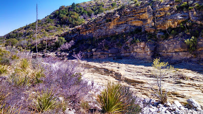
This hike was definitely easier than last week being mostly flat in the beginning. The McKittrick Canyon trail follows along the mostly dry stream bed, crossing through it several times as the trail and stream wind through the canyon. It was another clear blue sky day which made for some excellent views of the mountains on both sides of our hike. I'll let you enjoy a few pictures before I continue writing.


The next few pictures show the dry stream bed. For the first mile or so, there isn't any water flowing at all. From the looks of the erosion and the smoothness of some of the rock, it appears as though they get a whole lot of water flowing through here at times. But since we've been to West Texas, it hasn't rained that much.


After about a mile and a half down the trail we began to see a small clear stream flowing within the bed. It had a pretty decent flow rate going so it was a little puzzling. It seemed as though it may have been coming from a spring and then disappearing into the rock again. The way the trail weaved in and out, we never did see the beginning or the end of the water flow to know from where it came or where it went to. I figured on the way back, maybe we'll follow the stream bed instead of the trail to see how and where it originated.

About this time we encountered the park ranger hiking up the trail. I slowed a bit to let him catch up to me while the girls continued their pace. After a few minutes I asked him about the stream. He didn't really say it was a spring, but just that it began and ended.

He told me the story that the once land owner, Wallace Pratt (I'll get to him shortly), said the stream flowed constantly back in the 1920's and 30's through the canyon until it exited into the desert and dried up. Then in the late 30's and early 40's there were two floods. Mr. Pratt said that after the second flood, the stream just sank into the ground. And from then on it just flows on a few segments for a short distance.

So I still don't know how it originates or where it ends. But we will have to return again for another hike. Maybe we'll follow the stream bed then to find out.


So now for the next half mile or so, we're still hiking along with the park ranger and I notice on my GPS that we're getting closer to our first virtual Geocache (GC3A26). At about 300' away from the cache pointing to the right, the park ranger also says he has arrived at his destination. It seems we were going to the same place. Although he didn't know anything about Geocaching because I was explaining it to him along the way and that it was the main reason that had us hiking this trail.

We left the trail at these two stone pillars which led up to this old stone. The Wallace Pratt Lodge was the summer residence of Wallace Pratt (1885-1981), the principal donor of the lands that would become Guadalupe Mountains National Park. Pratt was a petroleum geologist employed by the Humble Oil Company, scouting for oilfield leases in west Texas. Pratt visited the Guadalupe Mountains in 1921, and taking a liking to the place, he bought a quarter share of the McCombs Ranch. There was at one time a road that led down into the canyon to the house. But the park service had it torn up and removed long ago.

In 1929 Pratt bought out his partners, ending up owning a large portion of the canyon, which featured waterfalls flowing over travertine dams, a lush, quiet place in the high desert. In the winter of 1931-1932 Pratt started construction of a house in the canyon, designed by Houston architect Joseph Staub. The cabin was built by Staub's former employee Vance Phenix and Vance's brother Dean, a carpenter, with stonemason Adolph May. The cabin was built of local limestone and heart pine. There was even a separate two car garage for their "his and hers" Mecedes-Benz's.The Pratt family spent summers at the cabin, which they called the Stone Cabin, and briefly lived at the cabin during Wallace Pratt's early retirement, while they built their final retirement home, the Ship On The Desert, outside of the canyon. The cabin accommodated the Ship on the Desert's architect during its construction. After the family moved to Tucson, Arizona, they donated the cabin, new house and surrounding lands of more than 5,000 acres (2,000 ha) to the National Park Service, the nucleus of Guadalupe Mountains National Park. The cabin was listed on the National Register of Historic Places on March 26, 1975.


So after touring through the old house, we thanked him and continued further up the trail. Now here's where it gets really interesting...


About another mile down the trail we catch up to another couple who left the Pratt House just before us. They were at a fork in the trail. There was a sign there pointing to the "Grotto" to the left and continuing the McKittrick Trail to the right. They asked us if we had been on the trail before, but this was the first time for us all. They were looking for the trail that took them to higher elevation to view the canyon. We wanted the correct trail that led to the virtual cache! They remembered something the park ranger had told them about the Grotto, but didn't remember if that meant to follow that trail. Our GPS was leaning 3.4 miles slightly right. But that doesn't mean much winding around through the mountains. So they went left and we went right.

About a 100' further and we began climbing. Now up to this point and for the last 3 miles to the visitors center, we ONLY had a 200' elevation increase! Now we were starting to climb. I think this was the way the other couple needed to go also.

Even though the elevation was increasing more dramatically, it was still a fairly easy trail for a moderate rating. Then we encounter the rocks!!! The trail went from a smooth incline to an extremely rocky, big boulder steep incline! This was more like rock climbing than a hiking trail. Even the severe rated trail for the peak wasn't this rough. But we're adventurers, so we continue on. Perhaps it's just a short rough section that gets back to normal just around the next boulder. And according to the GPS, we're still heading in the right direction.

Continuing to climb, up another 100', then another 100', just when you think that if you climb over this spot and around that corner, there we'd find the normal trail again. Somewhere around the 400'-500' mark, it looked like a split so I quickly went ahead to the left to see if there was a way through. Nope that was a dead end. So I yelled back to have them head the other way.
I went ahead quickly up that side as well and saw no end in sight. It was just more large rocks and steep climbing. Finally I suggested we call it quits and head back down. It looked like we were getting closer to the top, but I'd hate to have climbed another 200'-300' only to encounter and dead end cliff wall.

So we all agreed and headed back down the rocks. Finally we get back down to the normal looking trail when suddenly there's a fork in the trail. WHAT? We don't remember that! Where did THAT come from? I zoom in on the GPS and noticed that we had came from the left. NO WAY!!! The TRAIL actually switched back to continue up the other direction! We didn't even notice that. So in reality, we were NOT climbing up the trail but just a rock wash.


The two pictures above don't do justice, but kinda give you a sample of what we climbed. We didn't take many pictures in that area as we kept our phones in our pockets to keep our hands free for climbing! In the photo below, you see the thick trees at the bottom? Down in there is where we missed the switchback on the trail. Now from there follow the crevice up the left to that large shaded area. That's about where we climbed to before turning back down.


So while we were at the switchback, three hikers came through and we asked if they had been on this trail before. Nope, it was their first time as well on this trail but said they hiked a lot. It showed as they walked fairly quickly. After debating a brief moment, we decided to continue forward on the correct trail to see where if we could make it to the other virtual Geocache, still more than three miles away. But that was a straight line distance, not the actual trail distance.

We caught up with the three hikers after a couple of switchbacks as they were seated and grabbing a snack. One of them began asking us what our plan was and if we had a car parked at the visitors center. He informed us that the front gate would be locked at 6:00 pm and we should be back at the visitors center by 5:30 in order to make the drive out the gate in time. By now it was 2:30 and there was no way to make it to the virtual cache AND still have time to make it back. So we decided to turn around and head back.

Just about that time, the couple we met by the Pratt House and later at the fork to the Grotto came walking down the trail from further up. They were puzzled at how they had passed us when I explained about our misfortune of making the wrong turn and we hiked up the rocks. They said the Grotto wasn't that far down their trail which they took. After looking at it, they doubled back and followed the trail we took. They however made the switchback and passed us while we were rock climbing.


The walk back was brisk, yet seemed to take forever. Especially that last mile! I kept watch on the GPS and it wouldn't move for long stretches as we rounded the base of a mountain along the trail. It just kept pointing to the mountain as we had to round the base to the other side. Then the compass would point straight and we'd start closing in on the car. But the needle would start to veer off to the side again as we rounded another corner. Our total hiking distance according to the GPS was 9.19 miles.

It was another great Geocaching adventure and a fun hike. Not as sore this time as last week. Even with our wrong turn climbing up the rocks, we still had a good day. Candy's co-worker also enjoyed her day hiking and learning about Geocaching. It's too bad she's being transferred in a couple weeks. Maybe we'll be able to get one more hike in before that.

That's it for now. See you back again next time.