Showing posts with label mountains. Show all posts

Saturday, January 9, 2021

2019-04-20: Geocaching, Hiking, and Exploring the Beautiful Wichita Mountains Wildlife Refuge in Oklahoma

For today's adventure, we are once again Away-WE-Go for this Easter holiday weekend. Most of these blog posts I'm usually by myself on my Sunday drive back to work. Having this long weekend off, we decided to take a drive up to Oklahoma.


If you recall last month on my long roadtrip back from Minnesota, I had stopped at the Wichita Mountains Wildlife Refuge. I mentioned that they perform a live Passion Play every Easter and have been doing it for nearly 80 years. You can read more about that by revisiting my blog page here. Candy and I thought it would be a great idea to go and see it. So we drove up yesterday.

The granite walls of the Wichita Mountains offered refuge to waves of people over many centuries, beginning with Nomadic Native Americans. In the late 1800's, conservationists made plans to re-establish bison and other imperiled species in the region. Looking for the best habitat, they decided that the sheltered prairie of the Wichita Mountains was the ideal location.

This morning we came here to see more of the natural refuge, do some hiking, and hopefully see some wildlife. For our first stop we drove over to French Lake and parked by the Bison Trail for a hike over to the dam. The many dams located in this refuge which form all the lakes were constructed in the 1930's as park of the Federal Work Projects. We hiked the Elk Trail back to the GeoJeep. It was a pleasant, clear, perfect weather morning. Got some nice views of the lake and the dam. The only wildlife we saw was a bunch of turtles and some fish in the lake.


From there we drove south on Indiahoma Road down to our first geocache. The "Heart Rock Earthcache" (GC3AQ2J) is a large outcrop of lava rock forced up from below the surface. Many, many years of erosion created this heart shaped rock on a pedestal that's about chest high when standing next to it. If it wasn't at such an angle, it'd make a great picnic table. While there is a pull-off parking area for the scenic views, there's no mention of this heart rock formation. Just another reason why I like geocaching to find the unique roadside attractions.


Just as we got back to the GeoJeep, we were just in time to see a parade of more than a dozen old tractors going by. Now I'm not really into tractors but seeing some antique machinery being driven down the road was pretty cool.


Back up on State Road 49 through the middle of the Refuge, we come upon Prairie Dog Town. A field of hundreds of prairie dogs running around and popping up and down from their underground city. I wish I had my Nikon camera with me but I left it back in Texas. So I only have this fuzzy phone photo. Takes good pics normally, but not so good when you zoom in close.


Next we drive over to the southside of Quanah Parker Lake to the Little Baldy Trailhead. Crossing the Quanah Creek Dam which forms the lake, we begin hiking the Little Baldy Trail. Little Baldy is one of the rocky hills within the refuge. We hiked up to the top of for the views and for the Little Baldy virtual geocache (GC1E4D).


Returning to the GeoJeep and continuing down the road a few miles we finally saw some bison. So we pulled over, took some photos, and watched for a while.


It was now mid-afternoon and we didn't plan very well. We're now out of water and hungry because we didn't think about bringing snacks or food. We stopped by the Holy City of the Wichitas for a quick look to see what of the situation. People were already gathering and picking out their spots to watch the Passion Play which was still 10 hours away from starting. Candy got a quick look around at the buildings. They had bottled water but nothing to eat. So we needed to go back into Lawton to eat and return later.

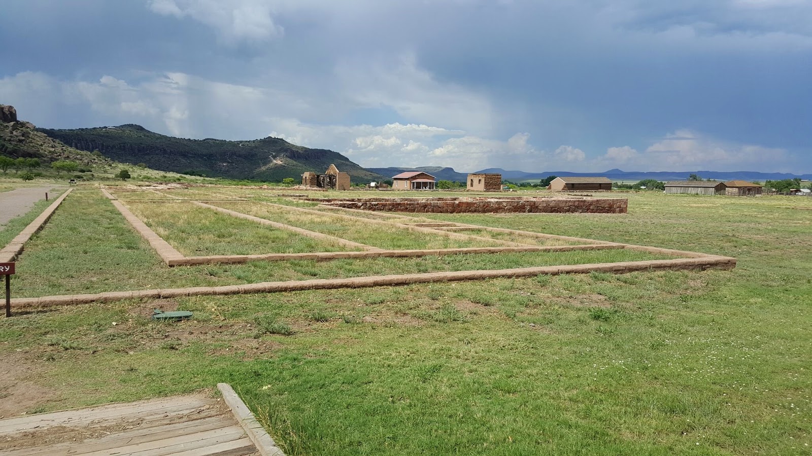
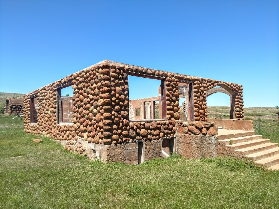
As we were driving out we stopped at this structure. Completed in 1927, Benjamin Ferguson and his family lived in this house until 1942. About a half mile to the east is the Ingram Homestead. They were both built out of the round granite core stones that cover the hillsides of the refuge, and both were acquired during the 1901 land lottery held at Fort Sill. They reflect the hard work, ingenuity, and craftmanship of earlier generations.

In 1942, the U.S. Army used the right of eminent domain to acquire the homesteads to expand the artillery range of the adjacent Fort Sill. Fifteen years later the planned expansion was scrapped and the homesteads became a part of the Refuge. In 1981 they were added to the National Register of Historic Places.


After grabbing some dinner and now back at the hotel to freshen up after all the hiking today, we were too exhausted to drive back to the Refuge to sit and wait for the play to start. But now that we have a better understanding of what it would be like, we're better prepared to come back again. Though next time we'll have folding chairs, a cooler with drinks, and plenty of food.

Still a great day of hiking and exploring the Wichita Mountains Wildlife Refuge. Come back tomorrow for the roadtrip home. I've got a few interesting places on the agenda for the roadtrip home. See you then...

Sunday, November 29, 2020

2019-03-10: A Packed Geocaching Roadtrip Returning from Minnesota to Texas Day 4: Oklahoma & Finally Home!

WOW, What a trip! This packed geocaching roadtrip from Texas to Minnesota began a week ago yesterday. Now I'm finally back home. But wait let me not jump ahead and leave out today.


CuteLittleFuzzyMonkey (CLFM) and I started out early this morning in Lawton, Oklahoma. After breakfast and coffee, we drove over to the Fort Sill visitors center. Fort Sill was originally staked out January 8, 1869 by Maj Gen Phillip Sheridan to stop Indian Tribes from raiding border towns in Texas and Kansas. The garrison was originally called Camp Wichita and was referred to by the Indians as "the Soldier House at Medicine Bluffs." Sheridan later changed the name to Fort Sill in honor of his West Point classmate Brig Gen Joshua Sill, who died in the Civil War.

Today it is a U.S. Army Base covering almost 94,000 acres. It serves as home of the United States Army Field Artillery School as well as the Marine Corps' site for Field Artillery MOS school, the United States Army Air Defense Artillery School, the 31st Air Defense Artillery Brigade, and the 75th Field Artillery Brigade. Fort Sill is also one of the four locations for Army Basic Combat Training. It has played a significant role in every major American conflict since 1869.

Because CLFM has a military I.D., it was a little easier for the both of us to enter the base, as long as he was driving. So we swapped seats and now I was the navigator. Our first goal was to find the grave of a famous warrior.

Geronimo (1829 - 1909) was a prominent leader and medicine man from the Bedonkohe band of the Apache Tribe. From 1850 through 1886, Geronimo fought against Mexican and United States military campaigns in Northern Mexico's Chihuahua and Sonora and in the United States' New Mexico and Arizona.

In 1886, he "surrendered" for his third and last time. This last time he didn't break out. He was first sent to San Antonio, TX as a POW. Then transferred to Fort Pickens in Florida, Mt Vernon Barracks in Alabama, and finally Fort Sill, Oklahoma in 1894. With the exception of becoming an "attraction" in Pawnee Bill's Wild West Show around the country, Geronimo spent the remainder of his life farming with his family on land surrounding Fort Sill. He died of pneumonia on February 17, 1909 after being through from his horse and laying out in the cold overnight.

He is buried there at Fort Sill among the rest of his family and other Apache POW's. His gravesite is the virtual geocache we came looking for (GC3B0D).


Also located within Fort Sill are our next two geocaches, a virtual (GCKPGE) and an earthcache (GC27G76). From the historical marker: "This Unique Landmark at the eastern end of the Wichita Mountains was noted, described, and explored by all early expeditions and was held in deep reverence by the Indian tribes of this area from time immemorial.

"The four contiguous porphyry bluffs form a picturesque a mile in length on the south side of Medicine Bluff Creek, a tributary of Cache Creek and Red River. It is evidently the result of an ancient cataclysm in which half of a rock dome was raised along a crack or fault.


"When Fort Sill was established in 1869, the Indians named it “The Soldier House at Medicine Bluffs.” The site is rich in legends and history. You are facing the north side of bluff no. 3, which consists of a sheer cliff 310 feet high, rising abruptly from the creek. A rock cairn erected by medicine men on its summit was still standing when Fort Sill was founded. Here the sick were brought to be healed or disposed of by the Great Spirit, young braves fasted in lonely vigils seeking visions of the supernatural, and warriors presented their shields to the rising sun for power. Legends say that this was also a famous place for Indian suicides. The huge fissure between bluffs no. 2 and 3 was known as the “Medicine Man’s Walk.”"


Leaving Fort Sill, we loop around over to the Wichita Mountains Wildlife Refuge. Established in 1901, the 59,020 acre refuge hosts a rare piece of the past - a remnant mixed grass prairie, an island where the natural grasslands escaped destruction because the rocks underfoot defeated the plow. The refuge provides habitat for large native grazing animals such as American bison, Rocky Mountain elk, and white-tailed deer. Texas longhorn cattle also share the refuge rangelands as a cultural and historical legacy species. More than 50 mammal, 240 bird, 64 reptile and amphibian, 36 fish, and 806 plant species thrive on this important refuge.

The Wichita Mountains Wildlife Refuge is also home to many virtual geocaches and earthcaches. We don't have the time to find all of them, but we will go after a few of the easier drive by caches. The longer hikes along the trails will have to wait another day.

The first virtual geocache (GCAE84) is located by this rock structure. Kinda like a small cave to serve some purpose of an early settler.


Another virtual cache by the stone archway leading into the Medicine Bluff Park (GC2413). Then there's this small little man-made cave, though this one has a door (GC2412). You know I think we may have ventured into The Shire! These are all Hobbit Houses! Bilbo Baggins must be on another adventure.


Nearly 60,000 acres of natural beauty. No sighting of any elk, bison, or deer yet.


On April 4, 1926, Rev. Anthony Mark Wallock (1890–1948), an Austrian immigrant raised in Chicago, initiated an Easter service and dramatic production with cast of five in the Wichita Mountains of Oklahoma. The play quickly grew into a large, traditional passion play, attracting thousands of spectators each year. The 1926 Easter service, held near Medicine Park in the Wichita Mountains, drew two hundred visitors and grew to five hundred the next year. In 1930 approximately six thousand people witnessed the pageant. Oklahoma City's WKY radio broadcast the production live in 1936, and it was carried nationwide on two hundred stations. By the late 1930s the event annually drew more than 100,000 observers.

In 1934–35 the Works Progress Administration (WPA) built the present Holy City of the Wichitas five miles west of its original location. A dedication ceremony in 1935 commemorated the completion of numerous full-sized buildings and structures, including the temple court, Pilate's judgment hall, Calvary's Mount, the Garden of Gethsemane, watch towers, rock shrines, and perimeter walls. By the next year WPA workers had built the Lord's Supper building, Herod's Court, a chapel, and other amenities.

The script generally depicts Jesus' life from birth through crucifixion and resurrection. In its first years, the several-hours-long drama began in the early morning, between two and three o'clock, and culminated at sunrise with the resurrection. At sunrise in 1935 skywriter Art Goebel inscribed "Christ Arose," above the pageant grounds, and in subsequent years aviators were hired to write or to drop flowers at the end of the ceremony. Attendance peaked in the 1940's and slowly declined to as few as three thousand in the 1980's. In 1985, trying to bolster the crowd, the pageant changed its schedule to begin at midnight and end in the dark at four in the morning. In 1986 the start time changed to nine o'clock in the evening, although many traditionalists desired the sunrise ending. In 1997 three thousand people experienced one of the nation's longest-running Easter pageants.

The event has never charged admission. The 150-acre site is leased from the federal government by the Wichita Mountains Easter Pageant Association, a private organization. Situated in the Wichita Mountains National Wildlife Refuge, the Holy City of the Wichitas admits tourists during daylight hours.

This is also our next virtual geocache (GCAFF3). I tried to do a panoramic photo of the site, but it doesn't do it justice. You just gotta see it in person if you're ever in the area.


The next virtual geocache is located at the Jed Johnson Dam (GC1BE1). The Dam and Lake Jed Johnson was created in 1940 across the Blue Beaver Creek. Covering 57 acres, its primary purpose is preservation of wildlife habitat. The surrounding area is home to deer, elk, longhorn cattle, and bison.


Just one more virtual cache and then it's time to be heading south. This one was at a huge family sized picnic table at one of the campgrounds. Supposedly, the largest camping site picnic table in Oklahoma (GC5B5D).

One of the nearby towns that surround the WMWR is Cache, Oklahoma. And for a geocacher, it's mandatory to stop and find atleast ONE cache in cache! After a few photos by the "Welcome to Cache" sign, we drove to the nearby Pete Coffey Mennonite Church to grab the "Cache Stash" traditional cache (GC6GVYK).


So now it's after lunch, though we haven't even eaten lunch. We still have 300 miles and about 5 hours of driving to get home, CLFM even further. So we skip all remaining geocaches and make a beeline for home stopping only for food and gas. It was some long days caching well into the night. After 119 caches, dozens of new counties, and over 3000 miles later, it'll be good to be home. (And that doesn't even include all the geocaches that CLFM managed to get while I was in training meetings for two days.) Now I need a vacation to recoup from my vacation!

Now to plan the next roadtrip. There are new ways to follow me. Follow the blog directly by using buttons on the right of your computer screen. Or through various social media platforms:  FacebookMeWeParlerGabTwitterInstagramMAGAbook, and Reddit. Follow us on any or all of these platforms and whichever you choose, please leave your comments. We'd love to hear from you and it encourages us to continue sharing our adventures.

Sunday, March 22, 2020

2018-05-13: More Geocaches, a Bridge With a Swing, Ghost Towns, Cemeteries, and Texas History

On today's 360+ mile drive in my new GeoJeep, I find a swing on a bridge, some old cemeteries, an abandoned ranch house, a missing motel, and much more. There's a lot to see in Texas, so let's get started.

My first stop after leaving Killeen is the Bear Creek Cemetery in Bertram and my first two geocaches (GC7DVVQ, GC442E2). Established in 1865, this cemetery has over 1500 permanent residents here. This one in particular is Texas Ranger Millard S. Moreland who died in 1891 at age 35.


Continuing westbound on Hwy 29, I arrive at the Colorado River and the Old Inks Lake Bridge. Built by the Austin Bridge Company in the mid-1930's, this truss bridge is now a pedestrian bridge after the new bridge was built along side. I parked at the east end to grab that first cache (GCMQ7H) near the entrance.

I started to walk down towards the other geocache on the bridge, but it was almost to the other side. Plus the last few cachers had logged DNF's. Having second thoughts, I was about to turn around back to the GeoJeep. But then I figured I'd walk across and get some good photos from the middle. Well it was a good thing I did. I've been on plenty of old bridges. But this was the first time I ever saw a swing on one! (See the first pick up top.) Now that's what you call a swinging bridge! Took some more pictures, then looked and looked and found the missing geocache (GC52MVG).


Moving along down the road, I exit from Hwy 29 onto US-377 in the community of Grit, Texas. A few miles down from there I stopped for a quick roadside geocache called Weird Rock Ranch (GCZMJT).

A couple of miles later there was another roadside geocache for a Texas ghost town called Streeter (GC11953). The first settlers were Irish (1855) and within a few years they were joined by German immigrants. Settlement was first along Big and Little creeks and Honey Creek and the town was first known as either Bluff Creek Community or Honey Creek Community.

In September, 1890, a post office was established and the submitted name was Streeter after early settler Samuel T, Streeter. In 1870 a Baptist church formed and the town had a cotton gin and a flour mill. There had been a school, earlier, on Honey Creek, but Streeter didn't have a school of their own until 1900. Streeter was quarantined for smallpox in 1903 and telephone service began in 1917. The post office closed its doors in 1970. The population of Streeter which had been reported as 100 people from 1925 dropped to only 60 by 1964. Streeter has since rebounded to about 100 people.

Nothing to see except the old house near the cache which was buried deep in the trees and overgrown brush. Supposed to be a cemetery there too but not exactly sure where.

I did find Gamel Cemetery to the southwest. There wasn't a geocache hidden there and unfortunately all of my geocache supplies were back in the GeoPrius in Fort Stockton. But I did look around a little bit at the headstones and hiding places. I'll talk a little more about this cemetery when I return to hide a geocache soon.


Continuing southwest on US-377 towards I-10, I got off the main road to get to my next geocache. On the corner was this old abandoned house engulfed by nature. It would have been cool to go in and explore, but being on private property that's not such a good idea.


I made it to Red Creek Cemetery (GC1JR4E). Red Creek Cemetery is located in Kimble County. There is no sign identifying the cemetery.There is no historical marker. The land for Red Creek Cemetery was donated to the Community by Frank Latta on 23 May 1896, to be used "for general burial purposes." The first marked grave is that of T. Roy Black (31 August 1897). Frank Latta was laid to rest here 23 March, 1902.

Three young men who made the supreme sacrifice for their country repose here in final rest. Thomas St. Clair lost his life in World War I in Europe; a memorial stone in tribute to Lloyd G. Ivy was placed here following his courageous death in World War II; and John Wilbur Gentry (World War II) rests here. The latter's brother, Lawrence Gentry, lost his life while serving as a military mechanic during the second World conflict. At least eleven veterans of the Civil War - one who served the Union Army and ten who fought for the Confederate cause - are among early settlers buried in Red Creek cemetery.


Continuing south on Ranch Road 385 for a couple of miles, I arrived at my next geocache at the ghost town of Yates, Texas (GC1M4K5). Yates, also known as Yates Crossing, is twelve miles northeast of Junction in eastern Kimble County. It was named by Joseph A. Yates, who opened a post office in June 1907 on his land near a ford of the Llano River on the road from London to Fredericksburg.

Camp meetings were held by early settlers under the live oaks near Yates. Tully J. Lange became Yates's second and final postmaster in June 1909. By the 1920's Yates was the center of a farming community in the Llano River valley. Throughout the decade Yates had a post office, a general store, a gas station, and a population that reached at least fifty-one. The area was advertised as a vacation spot for tourists and campers.

The post office closed in March 1930, and though Yates continues to be shown on maps, its last reported population was ten in 1958. Aside from a few scattered houses, the only thing business related that I saw was this old Kimble Motel sign.


Through Yates on this same spot on the Llano River is the Old Beef Trail Crossing. This Llano River crossing became a main line of the Spring cattle drives from 1867 to the 1880's. Capt C. A. Schreiner and his partners herded cattle on their way to Abilene and Dodge City on the Western Trail; many area cowboys rode with them. Preceded by a trail boss and chuck wagon, as many as 2,000 cattle per herd took half a day to cross. With the air full of dust, local ranchers sat on their own horses watching their own cattle closely to ensure that none of their own herd joined the trail drive. This site later became a vehicle crossing.


Back on US-377 south, I caught this old truck parked by this broken windmill and had to turn around for a photo.


Just down the road was my next roadside geocache near a historical marker (GC1M4J3). Teacup Mountain was named for its peculiar formation. Probably used as a lookout post by both whites and Indians in pioneer days. Near here occurred the Indian killing of pioneer James Bradbury Sr., 1872; and the capture of a wanted man by Lt N.O. Reynolds and four fellow Texas Rangers in 1878.


Named for the soaring Teacup “Mountain” to the west of the site, not much is known of this community other than there were 10 inhabitants at one time and they were served by a single store. The post office “may” have been located in the general store according to The Handbook of Texas. 1947 was the last year anyone bothered to count the number of residents and now there’s no one left to ask.

My last geocache of this trip was at Gentry Creek Cemetery (GC1M4HX). Raleigh Gentry was one of the first settlers in Kimble County, coming to the county in the early 1850's, when he settled on Bear Creek, some five miles with its junction with the North Llano. Here he built a home, erected stables, corrals, outhouses, cleared land and had an ideal paradise from a material standpoint. He prospered, farmed enough land to produce grain for use of his family and his stock, raised cattle, and enough hogs for his family use. In the early 1860's the war clouds gathered and became darker and darker, and finally the able bodied men had to go to war or join the frontier defense. Raleigh Gentry had six stalwart sons; Alan, Lee, Guliford, William, George, and Jack.


His son William married Nancy Frazier, but he answered the call of the Southland and joined the Confederate forces. He left his wife and son John at home, never to return.

In 1862, Raleigh Gentry sold his holdings on Bear Creek and moved some fifteen miles northeast and made a new location, now known as Gentry Creek, but here trouble awaited them. The Indians taking advantage of the lonely situation and the further fact that many of the men folks had gone to fight with the South made repeated raids on Gentry Creek, stealing horses and killing anyone that got in their way. On one occasion, two of the Gentry boys were hunting horses about a mile from home, when they saw the horse herd surrounded by a band of Indians and being driven off. The boys escaped to their home.

In 1867 Allen Gentry and his brother, Lee, went northeast to the Little Saline on a hog hunt and were soon joined by Felix Hale. Their hunt led over the line into Mason County. The part divided, Allen Gentry took one side of the creek, and Felix Hale and Lee another side in their hunt for the hogs. Allen was attacked by the Indians and killed in the very sight of his brother, Lee, who wanted to rush to the defense of his brother but he was told by Felix that it would be suicide and he would lose his own life. Hale and Lee dashed to the first neighbors' and gave the alarm, and parties organized to rescue the body of Allen Gentry and also to pursue the Indians. The body was found and placed on a blanket, and the four corners tied to a long green pole, and in this was the frontiersmen formed a hearse and conveyed the body to the residence of Matthew A. Doyle, the nearest neighbor, a distance of four miles. Here the body was placed in a hack and carried to the Gentry Creek. The body was buried in what developed into the Gentry Creek Cemetery.


Another buried here and worth mentioning is Dan C, Bird, grandson of George C. Kimble, an Alamo hero for whom Kimble County is named. Bird's son, Jack, passed away in California in 1981, and according to his wishes, Jack's cremated remains were scattered above Teacup Mountain that looms in the distance from Gentry Creek Cemetery.

That was it for today. Drove onto I-10 at Junction all the way to Fort Stockton. Thanks for stopping by and we'll see you next week for another tour of Texas.

Sunday, December 18, 2016

2016-11-20: Hiking and Geocaching in the Fort Davis Mountains State Park

Today was a day where the weather was finally cooling down enough here in West Texas to go out and do some hiking. YAY! We decided to start with an easy trail in the Fort Davis Mountains State Park. If you have been following along with us, you'll recall we made a stop here in Fort Davis not too long ago during one of our Geocaching Adventure trips. However at that time we didn't have time to do any actual hiking, just touring the remains of the fort.

For our first hike of the season, we chose the Indian Lodge Trail. With a length of 1.37 miles and having a "challenging" rating, I would have called it more of a moderate hike. The trailhead begins behind the Indian Lodge and ascends to the views of the Davis Mountains. The trail ends connecting with the Montezuma Trail leading down to the campgrounds. Adding in the short walk back to the lodge along the road, and I'd say our total hike was just over 2 miles in length.

And of course, what's a hike without doing a little Geocaching along the way! We found a total of seven caches today, including a FTF (first to find GC6VDZP) and re-found my very first Geocache (GCHE45) which I found back in April of 2006! The log had since been replaced so I couldn't get a picture of my first signed log though.

Overall it was a great hike on a perfect weather day with some great views! We'll have to come back soon and tackle some of the other trails and caches. Thanks for stopping by to read our blog. Be sure to leave your comments and let us know you stopped by. See you next time.


Re-found my very first cache from April 2006!


Monday, July 4, 2016

2016-06-12: More History, Cemeteries, an Old Fort, and an Oasis in West Texas

Hello again and welcome back to our Geocaching Adventures Blog. We hope you have enjoyed our stories so far and invite you to leave your comments below. Today's Geocaching Adventure has us driving deeper into the South West Texas to find Geocaches in each of the Brewster and Presidio counties. And being Texas where everything is bigger, driving just three counties over to get our first cache and a new county was 98 miles away! So let's get right to it...

Driving south on US 385, the first stop was an Earthcache (GC2KQE0) just north of Marathon, TX. This cache brings you a spot along the side of the highway where you can get a good view of how the earth buckles under the pressure of shifting continental plates.


Continuing south and into the town of Marathon, our next two Geocaches was at the Marathon Cemetery (GC272P8 and GC190F6). According to Albert Chambers, an early resident of Marathon, the first people who were buried in Marathon were six Chinese railroad workers. They were buried on the north side of what later became the Albert Chambers home. This burial site was slightly to the southeast of the Old Chambers Hotel, a local historical building. Mrs. Fannie Harris, a long-time Marathon resident, related that the next burials were south of the old George Harris home in Beakley Draw known as the Village Green. In 1905 a flood displaced many of the graves. Mr. Guy Combs and Mr. W.J. McIntyre donated land south of town for an Anglo cemetery as well as land for a Mexican cemetry. Additional land was donated by the Combs family in 1951. Mr. Lewis Harmon, another early Marathon resident, has stated that the first burial in the new cemetery was a Mr. Quick, although no record of his death has been located. The rock work for the entrance gate and four corner posts was done by L.Cordova in 1933. The plaque on one of the entrance posts was donated by Laura & Thomas B. Henderson. It reads as follows: IN MENORY OF THE DONORS OF THIS LAND Guy S. Combs, Nora C. McGehee, Lila C. Matthews, W.J. McIntyre, 1902 Marathon Cemetery Ass'n 1961.  A recent survey of the Anglo cemetery shows that there are 587 marked graves and approximately 127 unmarked and lost graves. Approximately 12 graves remain in the civilian cemetery at Fort Pena Colorado, and only one grave remains in the military cemetery. Several of the graves from these two cemeteries have been moved elsewhere. Many unknown graves are located on area ranches. No survey has been made of the Mexican cemetery.

A few blocks away was our next stop at the Marathon Oasis (GC22ZR4) located in a park called Gage Gardens. Part of the Gage Hotel and sprawling across 27-acres of lush greens, the Gage Gardens encompasses a native landscaped garden park with lovely ponds, beautiful fountains, nine-hole putting green, rose garden, vineyard, fruit orchard and a large fire pit with banquette seating. Guests can meander around the quarter-mile walking trail through the meticulously landscaped garden or take the more challenging one mile jogging loop with interval exercise stations. Blooming with colorful indigenous plants that flourish year round, the garden is a welcome home for migrating birds and butterflies, and provides the ideal spot for a relaxing walk with your partner or dog, an afternoon picnic, an idyllic wedding or private party.


Speaking of the Gage Hotel, built in 1927 for pioneer Texas rancher Alfred Gage by acclaimed architect Henry Trost and has 15 guest rooms. Next door to the hotel is the Albion E. Shepard House, now restored and owned by the Gage Hotel. In 1883, completion occurred of the extension of tracks by the Galveston, Harrisburg and San Antonio Railway Line located between El Paso and San Antonio. Retired Sea Captain Albion E. Shepard arrived in the region as a railroad surveyor. He acquired much land in the area. Tradition documents the naming of Marathon to Capt Shepards observations of the similarity of the valley and its encircling hills to Marathon, Greece, where the mountains meet the waters of the Mediterranean Sea. At this site, Capt Shepard applied for a Post Office in September 1882 where he became the first postmaster. The Marathon town site was created on December 6, 1885. This two-story home was built by Shepard in 1890 and was later acquired by a neighboring rancher of the Hess Family where it remained until the 1980's. Today it is owned and was restored by the Gage Hotel in 2012, containing five guest rooms in the main house with two rooms in the carriage house out back.


Another building of interest in Marathon is the "Club House." Built in 1888 and was the oldest school house in Brewster County, Texas. It was restored in 1928 and used for all public meetings and all elections.


OK, this was neither a Geocache or nor historical site. Actually I'm not sure what it is other than maybe the first, smallest, and original Target Store. I don't know exactly, but we were driving down the road and there it was out in the middle of nowhere. We just had to do a u-turn and get a photo. Just one of the many things you see while out Geocaching!


The next Geocache was a quick park and grab in a picnic area at the intersection of US-67 and US-90 where there was also a historical sign describing the Flat Rock mountains nearby (GCM38C).

A few miles further down the road was the town of Alpine, TX and our next Geocache (GC47NWN). On September 11, 2001, a ceremony was to be held for the ground breaking of the new building for the United States Border Patrol but was halted due to the 9/11 terror attacks of that day. Ten years later, another ceremony was held unveiling a piece of steel extracted from the rubble at the World Trade Center as a memorial to the victims.


View of the Texas Alpine mountains from the memorial.
Continuing west on US-67/90 for a few miles, we travel through the Paisano Pass and grab our next Geocache (GC478TC). From the historical marker at that site: "Legend recounts that two Spaniards meeting here greeted each other "Mi Paisano" (My Countryman). First known to history when Juan Dominguez de Mendoza camped here on January 3, 1684. Well known after 1850 as a point on the Chihuahua Trail, an emigrant road to California."

Next along the way is a small town called Marfa. We stopped for our next cache (GC2CZ32) at a rest area and viewing spot for the Marfa Lights. The Marfa lights, also known as the Marfa ghost lights, have been observed near U.S. Route 67 on Mitchell Flat east of Marfa. They have gained some fame as onlookers have ascribed them to paranormal phenomena such as ghosts, UFOs, or will-o'-the-wisp, etc. However, scientific research suggests that most, if not all, are atmospheric reflections of automobile headlights and campfires. It was late afternoon when we stopped and the only light we saw was a big ball of fire called the sun.

Heading northbound on our way back home, we stopped by Fort Davis National Park for a quick Virtual Geocache (GC5958). We got there within 30 minutes of closing and storm clouds rolling in. They had just closed the register and we told them we were stopping for the Geocache, so they just let us tour for free. We did a quick 10 minute walk through the grounds and Candy still managed to take 63 photos! And we avoided the rain by just a few minutes after exiting the parking lot.


Further up the road beyond the rain and one last stop at the Balmorhea State Park in Toyahvale, TX to get an Earthcache (GC1W9T6) and a Virtual Cache (GCD374). This place was packed! I think everyone in the county was here on this hot afternoon to cool off in the San Solomon Springs. Again we were only interested in the caches, so we informed the front gate upon arrival and they just let us pass without paying the entry fee. And again after 10-15 minutes we had the required answers and on our way.

Well that's it for today. Thanks for following along and we'll see you next time out on the Geocaching Trail...