Showing posts with label president. Show all posts

Saturday, May 7, 2022

2020-10-21: Geocaching Through History in Northeast Texas and an International Border

On this last day of our NC-TX roadtrip, I only had one goal for today, a bucket list item! That was to finally make it to the last surviving border marker between the United States and the newly formed COUNTRY of the Republic of Texas. We did stop to see a few other historical sites along the way also. This would finally wrap up our fourth state in four days. So without hesitation, climb aboard the GeoJeep and let's go for a drive! 


So we ended day 3 yesterday in SW Arkansas taking the backroads to pickup some new counties. The last caching county needed along our route was Lafayette County which we added first thing this morning by stopping at the Buckner Memorial Cemetery (GC38VDQ). And again resisting the urge to spend a lot of time looking around, I quickly found the geocache, signed the log, and continued into Texas.

Passing through Texarkana, we picked up US-59 and drove south towards the International Border Marker. After about an hour we stopped in historic Jefferson, Texas for a couple of virtual geocaches and a look around (GCC0AA, GCGAT8). Named in honor of President Thomas Jefferson, this town was loaded with history and had a lot to see.

The first stop around town was at the Jay Gould Railroad car. From the historical marker: "Built in 1888 by the American Car & Foundry Company of St Charles, MO, this was the private railroad car of Jay Gould (1836-1892). A native of New York, Gould was a noted financier and owner the of numerous railroad companies, including the Union Pacific, the Missouri Pacific, the International & Great Northern, and the Texas Pacific. This car, named the "Atalanta," remained in the Gould family ownership until the 1930's.


"Elaborately designed and elegantly furnished, the Atalanta features two observation rooms, two bath's, a butlers pantry, kitchen, dining room, and office. Interior materials include mahogany and curly maple woodwork, silver bathroom accessories, and crystal light fixtures.


"Following Jay Gould's death in 1892, the car was used by his son, George Jay Gould (President of the Texas and Pacific Railroad), and his wife, actress Edith Kingston. The car later was brought to Texas from St Louis and used as a family residence during the 1930's east Texas oil boom. Purchased in 1953 by the Jessie Allen Wise Garden Club, it was moved to this site in 1954."

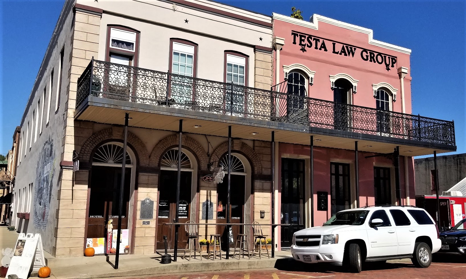
Captain William Perry was among the first settlers of Jefferson, arriving in 1840. Through his shipping business, he played an early part of the growth and establishment of Jefferson as an inland port. He bought and developed tracts of land in the area, becoming quite wealthy in the process. One of his developments was the Excelsior House. The oldest hotel in East Texas, the wood frame part was built in 1850's and the brick wing was added in 1864. Among its famous guests were Presidents Ulysses S Grant and Rutherford B Hayes, and poet Oscar Wilde. Added into the National Register of Historic Places, it was restored in 1963-64 by the Jessie Allen Wise Garden Club..


Below is the Kahn Saloon. Built during the early 1860's, this structure served as a boarding house and as a mercantile before opening as the Kahn Saloon in 1900. Temperance movement leader Carrie Nation was denied entrance here during one of her campaigns through Texas. The popular gathering place was closed after local prohibitionists won a 1907 election.

Jefferson native Marion Try Slaughter launched his career as country music singer Vernon Dalhart at the Kahn Saloon. Starred later for operas in New York, and recorded for Edison's talking machine. His rendition of "The Prisoner's Song" (1924) was the first folk ballad to sell over a million records, and led to rise of country music as an American art form. Within ten years he earned and lost a fortune, later living in obscurity.


One last item of interest in the history of Jefferson, Texas. Established by Boyle and Scott about 1875, Jefferson became home to the first ice factory in Texas. They sold ice at ten cents per pound. B. J. Benefield delivered the ice to their customers. The plant was later moved to Harrisburg.

Back on the road down to my bucket list geocache (GCTBR8). "In the early 1700's, France and Spain began disputing their New World international boundary that included this area; each nation claimed what is now Texas. When the U.S. purchased the Louisiana Territory from France in 1803, the boundary was still in dispute. Leaders agreed to a neutral area between the Arroyo Hondo and the Sabine River, and the 1819 Adams-OnĂ­s Treaty formally defined the border. When Texas became a Republic in 1836, it appointed a joint commission with the United States to survey and mark the established boundary from the Gulf of Mexico up the Sabine River and on to the Red River. John Forsyth represented the U.S., and Memucan Hunt represented Texas in the work, which proved to be long and difficult.

"The survey crew began the demarcation process on May 20, 1840 at the Gulf, placing a 36-foot pole in the middle of a large earthen mound. Proceeding north, they placed eight-foot posts denoting the number of miles from the 32nd parallel. Upon reaching the parallel, they placed a granite marker on the west bank of the Sabine River. From that point, they traveled due north to the Red River, completing their work in late June 1841.


"As a result of erosion, the first granite marker on the Sabine fell into the river long ago, but a second granite marker on the northward path of the surveyors had been placed here to mark the north-south meridian. This is the only known marker remaining, and it is believed to be the only original international boundary marker within the contiguous U.S. Today, the border between Texas and Louisiana follows the Sabine River to the 32nd parallel, at which point it connects to the boundary established by Hunt and Forsyth. The Texas Historical Foundation purchased this site to provide public access to the early boundary marker."

So if you're like me and one that stops to read historical markers, this one should be on your bucket list. And as a surveyor, I thought this was especially cool that it being the ONLY one like it in the U.S.

That was all the stops for today. We continued the rest of the way to Killeen for a couple of days before heading to West Columbia. There we start our next project and will be in that area for a few months. Soon I'll be bringing you our adventures from SE Texas. See you back again soon...

To follow along on our travels and keep up with my latest blogs, you may do so here of course. But also by using your favorite of these social media platforms: FacebookMeWeGabRedditParlorTwitterRVillageGETTR and Instagram. These all link directly to my profile. Again, please feel free to comment and / or share.

Saturday, February 12, 2022

2020-09-20: Walking Around the Historical Augusta, Georgia and Finding a Few Geocaches

On this second day of our roadtrip, we started out in Augusta, Georgia. We've passed through this city many times but never really taken the time to explore it. So this morning before we continued the rest of our drive up to the RV park in North Carolina, we spent some time checking out the historical riverfront area of Augusta. So let's take a walk through this historic community.

Founded in 1736 on the western bank of the Savannah River, Augusta, Georgia became the second town of the 13th British colony. General James Edward Oglethorpe, the colony’s founder, ordered the settlement and chose its location at the head of navigation of the Savannah River below the shoals created by the fall line. Oglethorpe’s vision was to establish an interior trading post for purchasing furs and other commodities from Native Americans to compete with New Savannah Town, a small outpost on the South Carolina side of the river.


Augusta thrived as a trading post from the beginning, with several of the South Carolina traders moving their base of operations to the new settlement. By 1739 a fort was completed, and the official surveyor of the colony, Noble Jones, laid out the town. Its colonial plan was similar, but not as elaborate as the one used in Savannah. Augusta’s plan focused on one large square or plaza and was four streets deep and three streets wide. Fort Augusta was adjacent to the 40 town lots on the west side near the river. Augusta named two of its original streets for Georgia’s colonial governors: Reynolds Street for John Reynolds, and Ellis Street for Henry Ellis. These streets are still prominent features of the Downtown Augusta, Broad Street, and Pinched Gut Historic Districts.


As traders populated the town, they brought their wives and began to have children. The desire for a more civilized atmosphere dictated the need for a church. As a British colony, Georgia petitioned the Society for the Propagation of the Gospel for a minister after constructing a church building in 1749. The first minister, the Reverend Jonathan Copp, arrived in 1751 and began conducting services according to the rites of the Church of England. After Georgia’s division into parishes in 1756, the Augusta District fell into St. Paul’s Parish, and the Augusta church became known as St. Paul’s Church (GC7B87M).


The brick pavers above layout the site of the first church in Augusta in 1749. The first church was destroyed during the French and Indian War (1754-1763). When rebuilt, the church became part of Fort Cornwallis until its destruction in 1781, in the Second Siege of Augusta, during the Revolutionary War. The Trustees of the Academy of Richmond rebuilt the third church on this property in 1789. This church was where the First Presbyterian Church was founded in 1804. Later, the congregation would build a new church on Telfair Street and move in, in 1812. The Episcopalian congregation would regain ownership in 1818. Robert Lund designed a new church which was completed and consecrated in 1821. The congregation grew and built a church school in 1843, with an orphanage added in the 1850's. During the Civil War, the property served as a hospital for the Confederacy.


The Great Augusta Fire of 1916 burned the fourth church, along with over 30 blocks of downtown Augusta and Olde Town. Fortunately, they were able to save some of the church furniture. Services continued to be held under a tent and at the courthouse until a new home could be built. The fifth church is the one we see here today. The exterior was designed to resemble church number four, Federal Style. The interior was redesigned in the Georgian style. The baptismal font is from the first church and many items rescued from the fire, from the fourth church, are still in use here today.

According to the Find-A-Grave website, there are 166 burials scattered about on the St Paul's Church graveyard (GC1PA14) dating back to 1754. The cemetery is still used today though not as often as I'm sure even a small burial plot is prime real estate and very expensive.


After the Revolution Augusta became the temporary capital of the new state of Georgia between 1786 and 1795, and many of the leaders of the government moved to the town. One of the most notable was George Walton, a Signer of the Declaration of Independence, who built his home, Meadow Garden, on what was then the outskirts of town. The other of Georgia's Declaration of Independence signers, Colonel William Few Jr, was buried at the St Paul's Cemetery in 1828.


The town continued to grow in size and population governed by a group of Trustees of the Academy of Richmond County. In 1791 they added Telfair Street, named for Georgia Governor Edward Telfair. Telfair Street today is another major artery through the Augusta Downtown and Pinched Gut Historic Districts. President George Washington’s visit in 1791 was a highlight of this period. Legend has it that Augustans planted the large ginkgo tree in his honor at the proposed site of the Richmond County Courthouse, constructed in 1801 and now known as the Old Government House. The Trustees of the Academy built a new school building in 1802, the old Academy of Richmond County.

As Georgia expanded westward and the states of Alabama and Mississippi attracted many of its prosperous planters, Augusta’s economy began to stagnate. The Charleston and Hamburg Railroad in South Carolina reached a point directly across the Savannah River from the heart of downtown Augusta in 1832. In 1833 the Georgia Railroad, chartered in Athens, Georgia, began building westward from Augusta toward a yet unnamed settlement that would eventually become Atlanta.


The railroad did not ensure Augusta’s future, as the tug on Americans to move westward grew ever stronger, but other factors had a positive impact on the city. Spurred by the invention in 1793 of the cotton gin, local farmers grew upland cotton in the surrounding countryside making Augusta the center of a large inland cotton market.

Augusta served as a major center of the Confederacy, providing cotton goods, shoes, guns, munitions, food, and many other commodities. In addition, the city was a religious center of the South hosting meetings for the formation of both the Protestant Episcopal Church in the Confederate States of America at St. Paul’s Church, and the Presbyterian Church in the Confederate States at First Presbyterian Church. The meeting took place there at the invitation of its pastor, Reverend Joseph Ruggles Wilson, who lived with his family in the parsonage, the Woodrow Wilson Boyhood Home.


Next door to the future President’s home was the parsonage of First Christian Church, home of future U.S. Supreme Court Justice Joseph R. Lamar. Wilson and Lamar, both sons of prominent Augusta pastors, were best friends as children.


Following the Civil War, Augusta’s economy struggled but rebounded with the enlargement and expansion of the Augusta Canal in 1875. Several large new cotton mills were built along its banks. As the old city continued to expand, most religious denominations realized the need to establish a second congregation in the western end of the city, and often a third or fourth in the suburban areas. With the expansion of the Augusta Canal, the city was once again a thriving center of a cotton economy. Cotton warehouses lined Reynolds Street between St. Paul’s Church on the east and 9th Street on the west.


Augusta's Imperial Theatre began in 1917 as a vaudeville showcase named The Wells Theatre. On Sunday, October 6, 1918, over 3,000 cases of Spanish Flu were reported. With the death of 52 servicemen from nearby Fort Gordon, the city announced the closure of all public venues, including the theatre. The quarantine began October 7, and during this time Jake Wells encountered great financial difficulties. He sold The Wells to Lynch Enterprises. On November 27, 1918, shortly after the sell, the quarantine is lifted and the theatre opened two weeks later. The Wells Theatre's was soon changed to The Imperial Theatre. Throughout the early 1900's the theatre continued to provide the city of Augusta and the surrounding area with great entertainment. In 1929, as vaudevillian acts decreased in popularity and motion pictures enjoyed meteoric success, Miller decided to renovate the Imperial into a full-time movie house in the popular art deco style. Decades later due to the decline of the downtown area, the Imperial continued as a film theatre until it closed in 1981. In 1985 it was recognized for its architectural significance and reopened as a performing arts venue with the help of local performing arts groups like the Augusta Ballet and the Augusta Players.


Saw this sign on another business in the historic district. I'm don't think there is a long history to research here, but I liked the appropriate name for the bar and thought I'd share it with you.


In 2005, a statue was dedicated in the historic district and James Brown Plaza in honor of the "Godfather of Soul" (GC11BDX). Born in South Carolina in 1933, the family moved to Augusta when he was five years old. He began singing in talent shows as a young child, first appearing at Augusta's Lenox Theater in 1944. As a singer, songwriter, musician and one-of-a-kind performer, James Brown has thrilled millions around the world with his hit recordings and electrifying performances. 


While there is much more that can be said of Augusta's history and many more places to see, we still have a long drive ahead of us to the RV park in North Carolina. So let us get back on the road for now. Until the next time...

To follow along on our travels and keep up with my latest blogs, you may do so here of course. But also by using you favorite of these social media platforms: FacebookMeWeGabRedditParlorTwitterRVillageGETTR and Instagram. These all link directly to my profile. Again, please feel free to comment and / or share.

Saturday, November 20, 2021

2020-06-03: Another Geocaching Roadtrip Through the Backroads of Georgia

Well our time in Florida is done and it's off to a new project in North Carolina. According to Google it's just a simple 8 hour day trip drive to get there. But where's the fun in that! In reality, it actually took us 2 1/2 days to get there! We try to avoid the Interstate Highways and take the backroads, sightseeing and geocaching along the way.

On this first day of our roadtrip through Georgia, we visited several old cemeteries, old churches, and some other historical places. Finding 14 geocaches, we picked up 11 new caching counties in the process! So come onboard, ride along and see what and who we've found today...


Our first stop after leaving Florida was a geocache in the Howell Cemetery (GC2FPY3) for Echols County, Georgia. The cemetery has about 130 interments, most dating from 1916 through the present. But there is one burial listed on the Find-A-Grave website dated 1839. The small community of Howell once had a post office established in 1899 which remained until 1957. A township was incorporated in 1905, but it was eventually dissolved in 1995.


Also in Echols County is the Wayfare Primitive Baptist Church and Cemetery, previously known as the Cow Creek Baptist Church and Cemetery (GC3F0E8). The church was established in 1847 and the first meeting held in September. The cemetery has nearly 1800 interments and the oldest headstone dates back to 1845. 


At the end of the entry road, there is another historical marker describing an Indian skirmish at Cow Creek. "New here, on August 27, 1836, Georgia Militia companies commanded by Col. Henry Blair, Captain Lindsay, and Capt. Levi J. Knight, fought a skirmish with Creek Indians and routed them, killing two and taking several prisoners. During this summer the Indians had committed many raids and massacres as they traversed the border counties on their way to Florida to join the Seminoles. Georgia troops had been following them for weeks, and overtook this band in the cypress swamp, on the edge of Cow Creek."

Driving over to Lakeland, GA in Lanier County, I stopped by Camp Patten for my next geocache (GCT6ZP). Camp Patten was donated by Mr. Lawson Leo Patten (1896-1983) to the South Georgia Council of the Boy Scouts of America in 1965 to further promote the ideals and methods of the Scouting movement.


A half-mile up the road was the Burnt Church and Haunted Cemetery (GC121CF). One of the first churches constituted in the area was Union Baptist Church. It was organized on October 21, 1825 on the banks of the Alapaha River at Carter's Meeting House. Captain Jesse Carter settled the land earlier in 1925 to provide more room for his family, slaves, and hundreds of cattle. In 1836 as a band of Creek Indians passed on their way to join the Seminoles at Noochee, near present day Fargo, they set fire to the Union Church. It was later called the Burnt Church. (Note: I've found conflicting dates for the fire. Some websites have it as 1836 and others 1854. It's possible that there were two fires or that the church was rebuilt in 1854. The church also was subject to a restoration in 1998.)


It is said that the church and cemetery grounds are haunted. A teacher and several of her students, who were using the church as a school, perished in the flames. She and the children were buried along side one another, but time and weather has wiped away all traces of their graves. Stories are told though that loud, unintelligible voices of children can be heard and apparitions known locally as "walkers" can be seen among the many tombstones.

Perhaps one of those "walkers" is this unknown man who hasn't found his eternal rest:


Moving right along, a quick stop for a geocache in Berrien County (GC8CZCH). And a quick roadside cemetery geocache for Atkinson County (GC6NNX5). Continuing to check counties off the list, two quick geocaches for Coffee County (GC617BC, GC6047Y), including this obvious container hidden in plain site.


Moving right along into Irwin County, there was a quick park and grab in the town of Ocilla (GC5JPDC). Followed by a short woodsy walk in Paulk Park in Fitzgerald for Ben Hill County (GC507M3).


And then there's the Wild Hog Express (GC1FZ6C). Located in Wilcox County, the town of Abbeville is said to be the wild hog capital of Georgia.


Then when I got to Eastman in Dodge County, I had originally set to find a cache at the Eastman House in town. But there were some renovations being done outside making it too difficult approach and find the cache. So I quickly look up and find a cemetery cache outside of town.

I'm so glad that was the case because you know I like cemeteries, especially with an old church, and then toss in some history too! (GC1CX07) President Jefferson Davis, his wife and children arrived at this site on May 8, 1865. He had rejoined his wife 20 miles south of Dublin. Traveling with them were the Davis’ four children, Varina, Maggie, Jefferson, Jr. and Joseph. Traveling with President Davis was John Regan, Postmaster General of the Confederacy, Captain Gevin Campbell and Lt. Barnwell. Personal aides John Wood, Preston Johnson, son of General Albert Sidney Johnson, Francis Lubbock, the former Governor of Texas, and Colonel Charles E. Thornburn, a secret agent for the Confederate Government. Traveling with Mrs. Davis and her children were Mrs. Davis’ sister Margaret Howell, Mrs. Burton Harrison, the President’s private secretary, a seven-man mounted military escort, and some of the President’s personal servants.

The following morning the president’s party crossed the present Highway 341 at approximately where Friendship Baptist Road is now. They followed this route to what is referred to as 5 points. Further along Friendship Baptist Road they would come to Levi (Tiger Bill) Harrell’s farm where they stopped for the noon meal. Turning south, they passed through what is now Rhine and then west to the river.

Mrs. Davis was to remain behind and follow the next day. Fearing the roads would become impassable due to the heavy rains that had started to fall would heighten the chances of Mrs. Davis’ capture, Preston Johnson returned to the campsite to inform Mrs. Davis to leave immediately and join her husband in Abbeyville.

Many have pondered why the Davis’ didn’t stay in the Parkerson Church located just across the swamp. The Parkerson Church is the one of the oldest churches in Dodge County having been built in June 1831. (Dodge County being Pulaski and Telfair Counties at that time.) The original building was a log house built by Jacob Parkerson, a Revolutionary War Veteran who donated the land and the first to be buried here in 1843.


The second burial here is Private William Hannibal Weekes who died in the Civil War at the young age of 28. There are less than 300 total interments at this cemetery.


Next on the list was some more history at the Orange Hill Cemetery (GC8N95D) in Hawkinsville for Pulaski County. There are more than 3000 interments here dating as far back as 1833. There are many large and elaborate monuments here.


One broken headstone I'd like to tell you about belongs to 30 year old Tom Woolfolk. He was convicted of killing nine family members with a short handled axe in Macon on the night of August 6, 1887. He was tried several times in Bibb and then Perry, Georgia and was publicly hung on October 28, 1890. Up until the last minute he proclaimed his innocence. He was one of the last people to be hung before they did away with public hangings.

"The Shadow Chasers" by Carolyn DeLoach, (Woolfolk revisited), is a book about this case. The author uncovered much undiscovered evidence and was able to conclude that the actual murderer was Simon Cooper, a hired hand of the family. After Cooper's death, a diary was found that he had written, notating the Woolfolk murders just as Tom had stated. He had also written a statement, "Tom Woolfolk was mighty slick, but I fixed him. I would have killed him with the rest of the damn family, but he was not at home."


The victims are buried in Macon's Rose Hill cemetery. Its reported that thousands of people also came to Macon for the funeral. That they lined the streets of what is now Spring St. and Riverside Dr. as the horse drawn hearses went by. There weren't enough hearses in Macon/Bibb County to accommodate all the victims and many had to be borrowed from surrounding areas. The victims were Richard F. Woolfolk, father, then aged 54; his wife Mattie H (Tom's stepmother), aged 41; their six children, Richard F. Jr., 20; Pearl, 17; Annie, 10; Rosebud, 7; Charlie, 5; baby Mattie, 18 months old; and 84-year old Temperance West, a relative of Mrs. Woolfolk.

Tom is buried beside one of his sisters from his Father's first marriage to Susan M. Woolfolk. He was the youngest of 3 siblings from the first marriage. His mother passed away shortly after his birth at the age of 24. The sisters from the first marriage were not living with their father at the time of the murders.

One final quick roadside geocache (GC40DP0) in Twiggs County before calling it a day.

We found a total of 14 geocaches today and managed to pick up 11 new counties for our geocaching map. I hope you enjoyed the ride-a-long. Another big day tomorrow as we continue making our way through Georgia on our way to North Carolina.

To follow along on our travels and keep up with my latest blogs, you may do so here of course. But also by using you favorite of these social media platforms: FacebookMeWeGabRedditParlorTwitter, RVillage, GETTR and Instagram. These all link directly to my profile. Again, please feel free to comment and / or share.

Saturday, January 30, 2021

2019-05-04: Moving Day Roadtrip from Texas to North Carolina Day 2 in AL, GA, & SC Historic Cemetery, House, and Gas Station

Well after 16 hours of driving and geocaching yesterday, it's time to hit the road again for day two of my roadtrip from Texas to North Carolina. Todays drive will take me from Alabama, through Georgia, to South Carolina. So jump in and let's see what we can find!


My first stop was for the "Trussville Civitan" Alabama's First Geocache (GC126). This cache was hidden way back on January 2001. The are only 48 geocaches left that were hidden during that month. For geocaching statistics, there's a Jasmer Calendar that lets a cacher know what months their found caches were hidden in. I only had one open spot for 2001 and it was January.

So I arrived near the geocache location in the parking area of a park. At the center of the park was this Veterans War Memorial. Took a quick photo before I went for a walk.


There was a walking and biking paved trail down along the Cahaba River. There were quite a few people out getting their morning exercise along that trail. I'm more interested in what was in the woods and headed for that. Only a few hundred feet in and away from the curious eyes of the muggles, I found the 18 year old prize that has been found nearly 1700 times and added my name to the log. YAY! Now just two more spots for July and August of 2000 to fill in the blanks. Even harder as there are only seven of those in the United States.


Before leaving town I spotted this old gas station and just had to stop for a photo. The building was originally constructed as a Gulf Service station in the late 1950's. In 2013 the building was bought by Rocky Neason who turned it into the Classic Cars and Garage Museum. The station was transformed into a Standard Oil Gas Station replica and filled with many 50's & 60's era antiques collected by Rocky Neason during his 31 years in the industry. There was a 50's 2-seater T-Bird and a 60's mid-year Corvette behind the bay doors during my visit. But I understand the cars get traded out with his collection from time to time.


Moving along for a cache in St. Clair County, Alabama. "Final Resting Place" (GC7ETF0) is a geocache located in the Moody Cemetery. There are over 900 interments here dating back to 1860. With the muggle here mowing the lawn, I just found the cache and moved on.

A few quick park and grab caches for Calhoun County (GC82XM4, GC36J12) and a Dunkin Donuts coffee. Crossing the state line into Georgia, I exit I-20 for two more quick caches in Carroll County (GC7F5J3, GC7F5GY).

Now I'm in downtown Atlanta. Not my favorite place to be. But there are some "must do" geocaches there. Fortunately it is Saturday so traffic isn't too bad. The first is a D5/T5 challenge cache called "The Lower 48 States" (GC5EQQT). Located a couple blocks from the state capital, it is an easy cache to find yet a very difficult cache to claim. It requires you to find at least one cache in each of the lower 48 states. I've managed to find one in 49 states, only missing Hawaii.

Then I take a drive over to the historic Oakland Cemetery. It was established in 1850 as the Atlanta Cemetery on 6 acres of land southeast of the city. It was expanded to 48 acres by 1867 and renamed in 1872 to reflect all the oak and magnolia trees. The magnificent entry gate pictured below was constructed in 1896. From 1936 to 1976, the cemetery is neglected and fall into disrepair. The cemetery was placed on the National Register of Historic Places and a restoration began. Eventually the Historic Oakland Foundation was created and maintains the grounds. An average of 105,000 visitors tour this cemetery every year. Today it is my turn.


There are two virtual geocaches there. The first one I found is for "The Master" (GCD42A). The geocache is dedicated to one of golfs greatest players, Robert Tyre "Bobby" Jones, who won multiple Masters Championships in the 1920's. You'll find his headstone at the coordinates.

The other virtual geocache is called "The Lyin' Cache" (GC64DF). Oakland’s most centrally located character area is the final resting place of approximately 7,000 Confederate soldiers, many of whom are unknown. Following Oakland’s acquisition of additional land, this four-acre portion of the cemetery began its transformation in 1866 by the Atlanta Ladies Memorial Association (ALMA). Several hundred of these graves were originally marked by simple painted wooden headboards, then replaced by marble markers with rounded tops in 1890.

Near the center of the Confederate Burial Grounds, Oakland’s tallest monument is a sixty-foot granite obelisk memorial to the Confederate Dead. Erected by the ALMA, the foundation of Stone Mountain granite was laid in 1870, on the day of the funeral of Robert. E. Lee. The monument wasn’t completed and dedicated until Confederate Memorial Day, on April 26, 1874.

Flanking the obelisk to the northeast, the Lion of Atlanta monument commemorates unknown Confederate soldiers who died in the Battle of Atlanta. The large sculpture carved in marble from Tate, Georgia was commissioned by ALMA and unveiled in 1894. With the famous Lion of Lucerne as his model, T.M. Brady depicted a weeping lion, representing courage, dying on a Confederate flag.


(Jumping ahead to 2020... Sadly, political and civil unrest has led to vandalism of this nearly 130 year old memorial. On the nights of May 28, May 31, June 5, and June 6, 2020, members of BLM and Antifa went into Oakland Cemetery and vandalized the Lion statue, the Obelisk, some of the headstones, and one of the historical markers within the Confederate Burial Grounds. The geocache has been archived.)


The monument at the Neal family plot is one of the most beautiful in Oakland Cemetery. Mary Elizabeth (Lizzie) Neal was the daughter of Thomas Neal and Mary (Mollie) Cash. Before moving to Georgia from Louisiana three years earlier, she lost six siblings. She suffered from rheumatism for several months before her death. Her sister, Emma, cancelled a trip to the Arctic to care for her Lizzie in the last days of her life. Created by her father after her and her mother's deaths, Lizzie is thought to be represented by the woman on the right of the monument.


Three more interments here worth mentioning. Joseph Jacobs (1859-1929) was a businessman and pharmacist. While it was John Pemberton who invented Coca-Cola in 1885, it was Joseph Jacobs that introduced it to the public on May 8, 1886.

Also, there's Margaret Mitchell (1900-1949), author of the book "Gone With the Wind." On August 11, 1949, she was hit by a drunk driver while crossing the road at Peachtree and 13th with her husband on the way to see a movie. She died eight days later.

Finally, and jumping again forward to 2020, singer, songwriter, and actor Kenny Rogers was laid to rest in Oakland Cemetery on March 20, 2020.

All in all there are estimated to be about 70,000 interments here. I spent almost two hours exploring this cemetery and didn't get see it all. But I do need to get back on the road. It's late in the afternoon and I still have ground to cover. So let's get moving.

The next six geocaching stops were quick roadside or parking lot caches to get six new counties in Rockdale County (GC5GT56), Newton County (GC84173), Walton County (GC2X92M), Greene County (GC1AFQN), Taliaferro County (GC19WT6), and Warren County (GC1DZ99). Along the way traveling down these backroads, you often see houses or buildings that have long been abandoned and nature is consuming them. If you're anything like me you begin to wonder what they once were and what happened that allowed them to get to this condition.


Continuing over into McDuffie County we stop for some history. "The Rock House" (GC21JD6) is an 18th Century stone dwelling and is the only surviving house associated with the Colonial Wrightsboro Settlement (1768). Its builder, Thomas Ansley, used weathered granite, quarried in its natural form from the nearby geographic fall line, as building material. The granite, along with pine timbers and cypress shingles, gave the house a distinctive Georgia character. The architectural style of the Rock House is similar to stone houses in the Delaware Valley of New Jersey from which Ansley migrated. It is the earliest dwelling in Georgia with its original architectural form intact.

The home is now owned by the Wrightsboro Quaker Foundation and has been rumored to be haunted. The Augusta Paranormal Society visits this location from time to time.


Across the street is a large monument erected in 2002 among many small crosses. "The great tornado (Type 5) entered McDuffie County at RR Mile Post 42. At 12:45 PM, March 20, 1875 the Rock House lost windows, a cook house, corncrib and gin. In the center of the cemetery a giant oak was blown down. This marker was in the center of the tornados path." There are 18 names with dates listed of those who are believed to be buried there. The dates range from 1809 through 1848.

Continuing to research the history of the Ansley Family, the last name was Anne Ansley (born 1801 - died 1848) was the daughter of Abel and Lydia Ansley. Before she died, she married Willey Carter and they had eleven children. One of those eleven children was Littleberry Walker Carter, who eventually became the Great-Grandfather of President James Earl "Jimmy" Carter, Jr.


Crossing the Savanah River over into South Carolina, I stop at the Welcome Center for a quick geocache for Aiken County (GC1048M). Then take the first exit and drive north a couple miles for another quick roadside geocache to pick off Edgefield County (GC81EPX).

For Lexington County (GC4N3FV) it was "The Duck Inn Travel Bug Motel." A creative geocache container large enough to hold plenty of travel bugs and coins to move up and down the Interstate. And finally the last geocache of the day was in Richland County (GC4GX30).


Another long day of driving and geocaching. I continued to the town of Lugoff, SC where the next geocache is located. But instead of finding the cache, I check into a hotel. It's after 9 PM and I'm tired! Not a bad day though, picking up a lot of new counties and finding some historical places. I appreciate you riding shotgun and hope you enjoyed the roadtrip. We got one more day tomorrow to get to North Carolina. Until then, it's sleep time.

Saturday, November 28, 2020

2019-03-09: A Packed Geocaching Roadtrip Returning from Minnesota to Texas: Day 3 in Kansas and Oklahoma

Hello again and welcome to Day 3 of the roadtrip returning from a business meeting in Minnesota and driving back to Texas. CuteLittleFuzzyMonkey (CLFM) and I took three days driving from TX to MN. Do we make it back to Texas today? Let's get going and see...

We left Manhattan, Kansas at sunrise and headed east on US-24 down the road into Wamego, KS. The town of Wamego is the birthplace of Walter P. Chrysler. You'll also find the Columbian Theater where you can see turn-of-the-century murals from the 1893 Chicago Worlds Fair. Probably the most popular attraction is the OZ Museum and all the Toto statues around town.


But what CLFM and I came for was our first geocache, a webcam geocache (GCPGXD). There were several webcams around town. We took our pose in front of the United Methodist Church.


Our final stop before leaving town was the Old Dutch Mill (GC83C3) virtual cache. Built in 1879 by Dutch immigrant John B. Schonhoff on his farm twelve miles north of Wamego, this old mill was used to grind grain into flour and cornmeal. In 1925, thirty-five team and wagons moved the windmill to this site. Each stone was taken down, numbered, and rebuilt exactly as the original. A bust of Ceres, goddess of grain, is set above the window. The mill is 25 feet in diameter and forty feet high.


Then we backtracked a few miles to Manhattan, KS because we forgot about the virtual geocache at the Kansas State Vietnam Veterans Memorial (GC6887).

Heading south on Hwy 177 for a few miles, we arrived at Konza Prairie Research Nature Preserve. The Konza Prairie located in the Flint Hills and is managed by Kansas State University as a long term ecological research site. This vast ecological system provides some spectacular views as you arrive at the visitors center. This was once part of the 2923 acre Dewey Ranch and was purchased in sections by the Nature Conservancy and Kansas State University from 1971 to 1979 for a total of 8600 acres today. The Konza Prairie was named after the Konza Indians. It also offers a trail system that can be combined for a 6 mile loop.

There was a virtual geocache and an earthcache along the highway (GCB63B, GC1DJV8). Then there was another virtual geocache (GC6E84) on the westside of the preserve as well as another virtual "Ashland Community" (GC6E86) outside to the north. Looking at the satellite imagery, it looked like we should be able to drive around the outside and get both of those. We really weren't up for the 6 mile hike at this time. So we gave it a shot.

Getting to the Ashland Community was pretty easy and we parked right out front of the historical building. Then following Google Earth, we continued down the muddy road around and into the westside of the preserve. Drove right up to within a couple hundred feet of the old water well. Sure made it easier than a long hike. And with the muddy conditions, I got to put the GeoJeep in 4x4 mode again.


Now jumping onto I-70 west for a short trip to the hill overlooking Fort Riley. This virtual geocache brings us to an Atomic Cannon (GC698E). Now I've never even heard of an atomic cannon! This is why I love geocaching! According to the historical marker at the site of the cannon: "This is one of only three atomic cannons in existence. The other two are located at Ft. Sill, Oklahoma and the U.S. Army Ordinance Center in Aberdeen, Maryland. This cannon was placed in service on November 17, 1952 and was deactivated in August 1963. Two 375 HP engines were used to transport the 42-foot, 280-mm cannon at 35 M.P.H. to the desired firing locations. The cannon can fire a projectile 11 inches in diameter for more than 20 miles. This cannon was never fired."

From the parking area, you can see the barrel of the massive cannon pointing outward. Standing next to it, it's like the huge cannons on a Navy battleship. Looking back downhill, that's CLFM nearby, I-70 going left to right, Junction City to the far left, and Fort Riley way off in the distant right side.


Driving on US-77 southbound in Herington, KS, we stop at the Father Padilla Memorial Park. There we find a not-as-big-cannon and our next virtual geocache (GCACE0). It seems like a pea shooter by comparison.


At the park across the street was this bench that was just calling out for me to take a photo!


Back to I-70 westbound, we take a ride over to Abilene, Kansas. There we found a large boulder which marks the northern terminus of the Texas Cattle Trail (GCGA9K). The plaque gives a little history, including the following, over three million cattle were delivered here. The trail was in operation from 1867 to 1871. The dollars brought in by the cattle trade and those hustling the cowboys gave Abilene the foundation of prosperity that still carry it today. The wild wild west was definitely here! Gunfights in the street, fistfights in the saloons, and prostitutes working the cowboys made for many wild nights. The upper class citizens of Abilene desired a more reputable image and laws were passed here that brought the cattle trade to an end. The cattle drives moved west to cities like Ellsworth, Hays and Dodge. Abilene continued to prosper without the cattle trade and is still a successful community.

Also in Abilene, you'll find the Dwight D. Eisenhower Presidential Library and Museum. And of course it's also another virtual geocache (GCBB05). President Eisenhower was born in Texas and lived there until age 1 1/2. His parents then moved back to Abilene. There he grew up and remained until he joined the military. Even though after his military and political career he moved to Gettysburg, he always considered Abilene his hometown and where his Library and Museum was built.


Next on our target list was a virtual geocache at the site of the Old Salina Brick and Tile Company (GC2E7C). We got the required bit of information needed for the answer and moved on.

Also located in Salina, Kansas is some aviation history (GC7B69P). In 1942 the Smoky Hill Army Airfield was constructed southwest of Salina. When the base closed in 1967 it left Salina with one of the largest Municipal Airport runways in the world. Turns out that wasn't the end of Salina's aviation story. For many years aircraft parts were built in several of the old base buildings by several familiar manufacturers. In more recent years it has become home to K-State Polytechnic with pilot programs in flight including a unmanned flight program. Military aircraft are still a common site at the airport with several reserve units having training facilities on the airport properties. 38 years after the closing of the military airfield a record breaking round the world flight took off (02/28/05) and landed (03/03/05) on the historic runway. The "Global Flyer" was quite an event and this monument is the centerpiece of a newly dedicated park with extensive history of the Airfield.


Heading south from Salina on I-135, we go down a short drive to Coronado Heights Park (GC3483). Located up on a hill overlooking Saline and McPherson Counties. Coronado Heights receives its name from Spanish Explorer Francisco Vasquez de Coronado who visited central Kansas in 1541. He was looking for the Native American community of Quivira where he was told "trees hung with golden bells, and pots and pans were beaten of gold." Coronado didn't find his gold.

In the 1930's, the Works Progress Administration built a picnic area and castle like building out of Dakota limestone. There was also a traditional geocache hidden a short walk down one of the trails (GC1TNG5).


Continuing southbound on I-135, there's a roadside attraction photo opp and our next virtual geocache (GC348A). Though I don't know how I missed taking a photo myself. So I'll use CLFM's photo. This used to be the "Happy Chef" which stood outside the Happy Chef Restaurant in McPherson. Someone bought it and moved it here. Now it looks like Mr Moneybags from the Monopoly game.


On the way to Canton to pay respects to Edgar Miller, we found two geocaches (GC824R0, GCG6V6) on the road to and in the cemetery. Edgar was an 18 year old ranch hand who bravely rode across the prairie to get help for his bosses wife who was very ill. He was captured by Cheyenne warriors who tortured, scalped, and murdered him, leaving his body in the weeds. For the complete riveting story, visit the Santa Fe Trail Research website.


Then there's the "Nothing But Blue Sky" virtual geocache in Newton, KS (GCAE93). Located in Centennial Park is this huge piece of artwork sculpture created by three artists.


Finally making it down into Oklahoma, we make string of geocaching stops in cemeteries to claim new counties. One cemetery geocache in each county of Alfalfa (GC2BFZ3), Grant (GC3NNQM), Garfield (GC71GHP), Kingfisher (GCMJND), Blaine (GC4J0Y3), and Caddo (GC7KGVK).

By now it's getting late, already dark, but we're still going on. Also in Caddo County, in the town of Anadarko, OK, we stop by the former Rock Island Railroad Depot (GCGA01). Built in 1902, it is now a museum and a virtual geocache. The museum was closed at 9:30 PM while we were there, but I did manage to see the cool old fire truck parked out front.


Moving down to Grady County, we get our last cache for the day. A virtual geocache for another one of those miniature Statue of Liberty monuments (GCFC05).


We finish the day near midnight finally getting some sleep down in Lawton, OK. Twenty-eight geocaches, about a dozen new counties, and nearly 18 hours later I'm exhausted! But it was a great day for geocaching and sightseeing through history.

Until tomorrow... ZZZzzzzz........