Showing posts with label river. Show all posts

Saturday, December 5, 2020

2019-04-01: Geocaching and Exploring Early Mexican-American History in the Rio Grande Valley of Texas

Hello and Welcome Back! So after my long and packed roadtrip from Texas to Minnesota and back, I had another two weeks off before getting called back to the wind farm down in the Rio Grande Valley. I managed to get one week of work behind me before overnight and this mornings rains made it too muddy to work. But a rain day off from work means an extra day for geocaching and exploring early Mexican-American history of small towns in the Rio Grande Valley.


My first stop is the town of Roma, Texas, just a few miles down the road from where I'm staying. A new cache was published over the weekend called "Cactus House" (GC85FFK). Just a couple of blocks from Roma's point of entry bridge over the Rio Grande River into the United States, is an old long abandoned brick house that's been taken over by nature. I found the geocache on this Monday morning and a nice clean log sheet to claim a First-to-Find!


From there I went a few blocks over to the Roma Historic District. Not a typical border town settlement, Roma, founded in 1765, is distinctive for its historic high-walled, gated, family compounds that reflect strong ties to 18th century northern Mexico, which was then part of the Spanish Empire. The planning, colonization and land grant system was the brainchild of Jose de Escandón and focused on civil development. Today, Roma is the only American Spanish colonial settlement that preserves the character of Escandón’s town planning.

The community is directly across the river from Ciudad Miguel Alemán, Mexico. The Roma Historic District, a National Historic Landmark district in the City of Roma, contains architecture influenced by Spanish colonial culture and by the bustling 19th century Rio Grande trade route that brought goods and people from the Gulf of Mexico to the continent’s interior. The Roma Historic District contains the best and most intact collection of ethnically diverse buildings and structures in the border region.

The site of Roma was part of the Mexican town of Mier about 10 miles northwest of modern Roma, in what was New Spain’s Nuevo Santander. Don José de Escandón founded the Spanish colonial province of Nuevo Santander in the mid-18th century. Spanish colonists from Mexico settled Mier in the 1750's and received land grants along the Rio Grande, where they formed family ranches. In the 1760's, the Spanish colonial government granted two tracts on the northern side of the river to the Salinas and Sáenz families, who were among the founding families of Mier and whose descendants still reside in Roma. The tracts they received were the first permanent European settlements at the Roma site.

Soon after the Mexican War for Independence ended in 1821, Roma became an independent community. One of the earliest records of Roma is in American colonist Stephen F. Austin’s chart of Texas, which literally put Roma on the map. After the Mexican-American War ended, Roma belonged to the United States. In the 1840's, Euro-American entrepreneurs settled in Roma, Texas, and married into the founding families.

German immigrant and master-builder Enrique (Heinrich) Portscheller settled in the region in 1865, married a Mier woman, and eventually moved to Roma. Portscheller added to the beauty of the local building techniques with his trademark decorative molded brick and use of New Orleans-type wrought-iron balconies. In addition to his work in Roma, Portscheller designed buildings in the border towns of Mier, Rio Grande City, and Laredo. Though there are other towns where this type of brickwork endures, Roma sustains the highest level of density, integrity, and quality in its 19th century Rio Grande brick and stone craftsmanship.

The John Vale / Noah Cox House (GC7JGVK) served as both a home and business location for John Heinrik Vale and Noah Cox, who were deeply embroiled in Civil War activities in Roma. Vale, a Swedish immigrant, had come to America in 1840 seeking adventure. During the Mexican American War, Vale volunteered for Zachary Taylor’s Army of Occupation and was encamped in Camargo. He chose to remain in the region, marrying a woman from Ciudad Mier in Tamaulipas and taking up residence across the Rio Grande in Roma. In 1853 he built a two-story home on the town’s main plaza.


Three years later he sold the house to Cox, a representative of the New Orleans firm of Stadeker & Mecklinburger & Cox, who continued to use the house as both a residence and mercantile center. In addition to his mercantile operations during the Civil War, Cox also served in the Confederate Texas Cavalry. For his part, Vale engaged heavily in the lucrative cotton trade that funneled through the city of Roma during the Civil War, doing business with Joseph Kleiber, a key player in Confederate business operations on the Gulf of Mexico. 

The geocache I found, my second attempt at looking, was on the ruins of the wall which surrounded the side and backyard. Hopefully they don't completely restore this section of the wall because I like the way it looks now.


Also built by John Vale around 1850's, the Leocadia Leandro Garcia House is similar in style and construction to the Noah Cox House across the Plaza. Originally, the house contained commercial space on the ground floor with residential space above. The house was later remodeled as a building for a dance hall and now owned by the Knights of Columbus.


Manuel Guerra, the legendary political and economic boss of Starr County, commissioned Portscheller to build his family compound in 1884. A native of Mier, Guerra printed his own currency to be redeemed by his ranch workers at his store. The two-story brick structure sits assuredly along the upper western edge of the plaza, extending for half a block with fine classical brick detailing and a historic two-color metal balcony that delicately embellishes its second story. A one-story warehouse completes the L-shaped complex enclosing a courtyard with original outbuildings. Never to be outdone by competitors, the Guerra family also operated the first gas station in Roma with a pump installed near the chamfered corner entrance (since removed).


The seven men, pictured in 1911, in Roman collars and broad brimmed hats were Missionary Oblates of Mary Immaculate (OMI) who had travelled from their missions scattered throughout the Rio Grande Valley along the river. Since 1849, this Calvary of Christ have been building churches and chapels from Brownsville to Laredo.


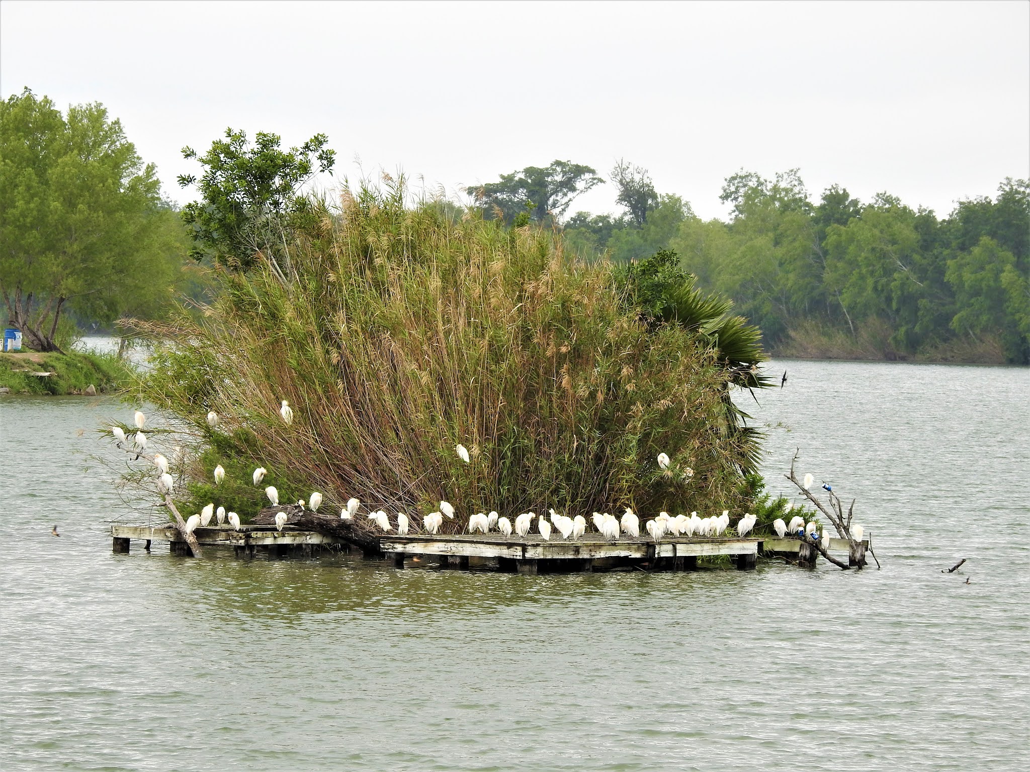
Arriving in Mission, Texas and turning back towards the river, I make another stop in Anzalduas Park. It's a riverside park popular with bird watchers. I was here once before and found a couple of geocaches. But there was one that I previously DNF'd (GC6AF7Y). Today was redemption as I found it this time. Out on the Rio Grande I could see why this park was popular among bird watchers.


At my next geocache (GC84NC2), I see the ruins of this structure up on the hill. Next to the Juan Diego Academy stands the remains of the Villa Queen of Peace (photo below and at top of page). Though the cache page says Oblate Monastery, I can't find any information about it's history or that it was indeed a monastery. So I'm not sure when it was built or what happened to it. If you have any information as to its history, please comment below.


Nearby was geocache (GC6Z60B) and my next piece of history. The La Lomita (meaning small hill) Chapel was constructed by the Oblates in 1865, then rebuilt in 1899 on these 122 acres willed to them in 1861 as it was nearly halfway between Brownsville and Roma. The Oblates moved their ministry to the growing city of Mission in 1908. Now it is a historical landmark, a park, and a place of pilgrimage.


Looks like an oven outside the chapel.


I hope you have enjoyed the sampling of early Rio Grande Valley history. There is much more to see if you every get the chance to be down in this area. I didn't even get to any of the cemeteries. Overall I managed to find many more quick roadside geocaches for a total of 32 finds for the day.

Until next time, I look forward to your comments here or on any of my social media accounts. Hopefully I have inspired you to go out and explore the rich history along the many backroads and small towns of this great country.

There are new ways to follow me. Follow the blog directly by using buttons on the right of your computer screen. Or through various social media platforms:  FacebookMeWeParlerGabTwitterInstagramMAGAbook, and Reddit. Follow us on any or all of these platforms and whichever you choose, please leave your comments. We'd love to hear from you and it encourages us to continue sharing our adventures.

Sunday, August 16, 2020

2018-08-26: Starting a New Wind Project in the Rio Grande Valley of Texas

Finally after nearly two years on a solar project in West Texas, it is completed. Now it's time for a new chapter. My next assignment is a wind farm located down in the Rio Grande Valley in South Texas. I'll be staying in a small cabin in Falcon State Park for a few days until I find something more permanent. The cabin is very basic. But it's a short walk to some great sunset views across Falcon Lake and the Rio Grande River.


As for the project, it's gonna be a small wind farm of just 66 turbines that stand 330 feet tall. They'll stretch from the Rio Grande River 12.5 miles back to this hill I'm parked on.


You often hear that you shouldn't drink the water down in Mexico. I'm not sure what it does to you. But if this monstrous praying mantis on the horizon is any indication, then I'll be sticking to bottled water!


Over these next months I hope to bring you stories and photos as I begin to explore South Texas. There are Geocaches to find and new counties to achieve in my effort to complete the Texas County Challenge.

See you back here soon...

Thursday, July 2, 2020

2018-07-04: The Quest For 10,000 Geocaching Finds: Necropolis of Britannia Manor GOAL COMPLETED!

YAY! 10,000 GEOCACHES FOUND!! A Huge Milestone Made Complete With An Awesome Milestone Worthy Cache!


But wait let me step back a moment. In yesterdays blog, I covered my first stop this morning at the Oakwood Cemetery in Austin, Texas, highlighting some of the historic occupants there. But what I didn't tell you was that I was also collecting clues for the milestone geocache. I had my sights set on making the Necropolis of Britannia Manor III (GC2B034) my 10,000 cache find.

Necropolis of Britannia Manor III is the second most favorite cache in Texas, and that's because the top spot is held by the oldest cache in Texas with a ten year head start. The Necropolis is a multi-stage story with eight chapters. It takes several hours to complete which leads you to an amazing final. The whole thing is an adventure onto itself. It's the only geocache I know of that even has it's own Facebook page!

So there are a few more caches I needed to find before getting to number 10,000, so as I was going around town I found a few more along the way. After leaving the cemetery, I grabbed a cache there on the corner of MLKjr and I-35 called Moonlight Tower #18 RIP (GC2MHWJ). It was one of the locations of the 1895 lighting tower project. Thirty-one lighting towers standing over 150+ feet tall illuminated the growing city. Only 15 remain standing, but not the one at this location.


I was passing by Mount Bonnell along the Colorado River where I stopped to take in the views and also grabbed a virtual cache (GC1436) and an earthcache (GC1WHVV).


Five more quick roadside geocaches and a local four-legged muggle watching nearby. And I've made all the necessary stops and gathered all the clues needed to take me to the final destination: the Necropolis of Britannia Manor III.


So I've tried not to give away any answers or clues for the stages. There's just a short walk from the parking area to the GIANT Geocache container. Along that walk you'll find many ghoulish displays and items to dare you to continue your journey. They say this one is best to do just after sunset, but I didn't have the luxury of doing that. But I'm sure this would rival many a haunted house. I'll leave you with just a few photos of what you'll find along the way as well as a pic of the Final Container. I took a video of the inside and was debating on posting it here as well. But I'll leave that as a surprise to you. If you ever find yourself in Central Texas anywhere near Austin, this is a MUST DO BUCKET LIST Geocache to find! And it forever marks my 10,000th find!


Sunday, June 14, 2020

2018-06-10: Geocaching Through History From Central to West Texas

Welcome back to another of my 360+ mile Sunday drives from Killeen in Central Texas to Fort Stockton in West Texas. Along this weekly drive, I explore the backroads and small towns, cemeteries and ghost towns, and anything of interest along the way. Most of the places I discover are thanks to the game of Geocaching. We got a long way to go, so let's get started.

Now most of the time during this drive, I start finding geocaches early along a route. Then I get side tracked, start heading to this cache and that cache, and next thing I know it's the middle of the afternoon and I still have 300 miles to drive. Today I was determined to make it past Llano before making my first stop. And that I did.

To encourage settlement of the new frontier in the 1830's and 40's, the Republic of Texas granted large portions of land to prospective impresarios. Among the more notable was the one issued to Francis Fisher, Buchard Miller, and Joseph Baker. Comprising some three million acres of land between the Llano and Colorado Rivers, it became known as the Fisher and Miller Colony.

Going westbound on Highway 29, I turned south towards Castell. In 1847 on Fisher-Miller land grants, 3 settlements were begun by German emigration company under commissioner general John O. Meusebach. There was Bettina, the first communal settlement in Texas. It was abandoned in less than a year when supplies ran out. Leiningen three miles to the east, but non-existent today. Castell was the first and only permanent Llano County settlement. It was led by Count Emil von Kriewitz. The towns namesake was Count Carl Frederick Castell-Castell, business manager of the Adelsverein.


The German Lutherans in this area were served by circuit-riding lay minister Dietrich Rode as early as 1870. A congregation was organized in 1893 on the north side of the Llano River in the Leiningen settlement about three miles east. A second church, known as Leiningen Two or Zion, was built on the south side of the river in 1907. The two congregations merged as St Johannes Evangelische Gemeinde in 1926, and a new sanctuary was built. Worship services were conducted in German until the 1950's, and the name was changed to St. Johns Lutheran Church.


Next to the church is the Cemetery and geocache (GC1NVGG). The congregation of St John Lutheren Church had been meeting in its new sanctuary for some four years when the death of one of its members, Anna Charlotte Lillie (Kowierschke) Bauer (1905-1930), led to the purchase of this half acre for use as the church cemetery. Her in-laws J. W. Bauer (1874-1932) and Bertha (Flint) Bauer (1872-1956) are buried nearby in the same plot. The older grave of Christian Schneider (1838-1920) was moved here from an endangered location near the Llano River.

There was a second geocache in town closer to the river, but I didn't find it (GC1NVGB).

Arriving in the town of Mason, Texas, there were two geocaches there that I still hadn't looked for yet. The first was at a historical marker entering the town (GC6E7PP). Created January 22, 1858 and organized August 2, 1858, Mason County was named for its most important settlement, Fort Mason. Garrisoned intermittently from July 6, 1851, to March 23, 1869, Fort Mason was named for Lt. G.T. Mason of the United States 2nd Dragoons, killed in Mexican War action on April 25, 1846 near Brownsville. Fort Mason was one of a chain of posts situated a day's horseback ride apart, from Red River to the Rio Grande, for protecting frontier from Apaches, Comanches, and other Indians.


Exiting the west end of town I stopped for another historical marker and another geocache (GC6E82Z). A native of Kentucky, Thomas S. Milligan (1810-1860) moved to this area in 1855 and operated a change station for the stage line. He was also a rancher and supplied beef to the soldiers at Fort Mason. Shortly after Mason County was organized in 1858 he became the first elected sheriff. Two years later he was killed by hostile indians near his home 1.6 miles NW. His grandson Allen Thomas Murray (1880-1929) became county sheriff in 1924 and like his grandfather, also died in the line of fire. He was killed by a bootlegger in 1929.

When arriving in the ghost town of Grit, Texas, I turned south onto US-377 to head down towards Junction and I-10. I then made a quick roadside geocache stop (GC3PV6R).

A couple of more miles down the road and I arrived at the Long Mountain Cemetery and two more geocaches (GC6EVX0, GC3PV5Q). Long Mountain probably gets its name from a nearby summit, also called Long Mountain. The area, which had been settled for some time by scattered ranchers, began to develop into a community in 1915. There are 240 burials here dating back to a Samuel Silas Jackson in January 1867. The second photo below is that of Dan (d.1900) and Sarah (d.1928) Martin's headstone which has their portraits on it. I'm sure it was placed by a more recent family member.


The next few miles provided just some ordinary roadside geocaches for some quick stops (GC3PV4T, GC58AJJ, and a DNF at GCKNF4). There was another roadside cache that had some history in the location, but nothing left there to see. The ghost town of Erna (GC1JR4C) is said to have been settled shortly after the Civil War, in part by German immigrants. J. N. Andrews operated the only store in the community in 1890. A post office was established there in 1915 with Amos Brewer as postmaster. The office was discontinued in 1919, and mail for the community was sent to Streeter in Mason County. Only a few scattered houses marked Erna on county highway maps in the 1940's. From the mid-1940's through the mid-1960's the population was reported at fifty. By the 1980's only the place name appeared on county maps.

An old farmhouse along one of the rural dirt roads.
The next geocache and ghost town down the road at the Saline and Little Saline Cemetery (GC1M4JK). A few settlers arrived in the area in the 1860's, but the threat of Indian raids kept many people away until the 1870's or 1880's. Shortly after 1900 the Saline school had eighty-four students and two teachers. The school and a church marked the community on county highway maps in the late 1930's. The school closed in 1947, and students were sent to the London school in Kimble County.

The family of Henry Parks settled here in the early 1860's, having found abundant grazing for their cattle. A band of Comanche Indians descended upon the pioneer family. Henry and Nancy Parks and their young grandson, Billy, were slain, their home burned and the cattle driven away. The Parks family were laid to rest where they had been slain. The three bodies, all in one grave, became the first burial in Little Saline cemetery.

The photo below is on the headstone of Marvin Harrison Hight who died December 1917 at age 22. I couldn't find any specific information on him, but I suspect he may have died in battle during World War I.


Continuing south on to my next cache (GC11951), I arrived in London. No not in England, but in Texas. London, aka London Town materialized sometime in the late 1870's or early 1880's when former Union Army officer Len L. Lewis moved into the area to trade horses. Lewis married locally and with holdings of a half-section of land, he planned the future town. Ed, Tom, and Robert Stevenson opened a store there in 1881 and the town was platted to include a square and forty town lots. A post office opened in the Stevenson store in 1892 under the name London and it was used to denote the town as well. London is famous locally for its dance hall located on the main street. The London Cemetery (GC6EG0K) has just over 400 burials dating back to 1908.


Jumping on to I-10 westbound, I continue on down to Copperas Cemetery (GC1M4H9). A deed for this cemetery was executed by D.P. Cowsert to E.S. Alley, County Judge, on May 30, 1890, donating one acre of land out of E.S. Haines Survey #55. First grave was that of William A. Cowsert on February 1, 1888. Residents of the Copperas community tend to cemetery. David Cowsert, who died during World War I, was returned home and buried here in the land of his ancestors. At least eight Civil War veterans , including Colonel John Griffith, were interred in the Copperas Cemetery. Veterans from other wars are among the dead in this beautiful little cemetery in the Copperas and Bois d" Arc valleys. An official historical law officers's marker denotes the burial spot of Ranger Captain Gully Cowsert.


Next door to the cemetery is what remains of the Copperas Methodist Church (GC1M4HA). Organized in 1881 by circuit rider, Andrew Jackson Potter, who helped firmly establish the Methodist church in West Texas. Before construction of church on this site in 1917, services were held in schoolhouse or under brush arbor 3/4 mi. SW on west bank, Copperas Creek. Building site was donated by J. A. Cowsert. Lumber was hauled here by wagon from Menard. Labor was donated by members and other local residents.


Five miles further down I-10 westbound is Roosevelt, Texas. Exiting off the Interstate, I first arrive at a historical marker and my next geocache (GC1M4GR). "From nearby Fort Terrett, this road in 1852 led south to Fort Clark and north to Fort McKavett. Selected mainly because it had water available, it served as the route for freight and mail in 1868, when the forts were reactivated. Over this route went troops, supplies, immigrants and pioneers. It was noted also for the passage of forays of Col. Ranald MacKenzie against hostile Indians to the northwest. After the forts were abandoned in 1883, ranchers drove cattle to market over parts of the road.

Near the historical marker was this old church. It was the Roosevelt Presbyterian Church. A plaque on the wall says the church was organized in 1933 and the building erected in 1947. The building looked to be in decent shape although the sign out by the road was pretty faded. With a population of about 150, I imagine it is still in use today.


Roosevelt, Texas was established with a post office in 1898 and was named by its founder, W. B. Wagoner, for Theodore Roosevelt, who reportedly visited the area with the First United States Volunteer Cavalry (the Rough Riders). It served as a shipping point for feed and supplies for local sheep and goat ranchers. The Patterson and Riek Ranch, established in 1897, imported Angora goats from South Africa in 1925.

In the 1920's the community hosted polo matches, as local ranchers bred polo ponies for national markets as well as horses for the United States Cavalry. Hill Country tourism also added to the local economy in that decade with the establishment of several businesses, including the Luthringer Hotel.

The population of Roosevelt, estimated at twenty-five in 1925, averaged 100 from 1941 through the middle 1980's. In 1990 it was ninety-eight. The population dropped to fourteen in 2000.

The old general store (GC1M4GB) in Roosevelt known as Simon Bros Mercantile opened in the early 1900's and is still in operation. The Back Door Cafe is located behind the store and contains a beautiful mahogany bar that languished for many years in a local barn. The remains of the school and the memorial church are located east of town.The post office is located inside the store and is one of the two smallest still operating in Texas (the other is at Telegraph).


Well it has been a busy day with 18 geocaches and a lot to see. From Roosevelt I still had 180 miles to go and was planning to drive all the way through to Fort Stockton. But after about an hour, I-10 was getting pretty boring! About halfway I was approaching a rest area. I opened up the app and saw that there was a cache there (GC2K4XW). Well that's a no-brainer. I quickly pull in, stretch my legs and grab a cache.

Now on to Fort Stockton to relax for the night and get rested for work tomorrow. Thanks for stopping by. If you've enjoyed my stories, please send me a note in the comments, or through Facebook and Twitter.

Sunday, March 22, 2020

2018-05-13: More Geocaches, a Bridge With a Swing, Ghost Towns, Cemeteries, and Texas History

On today's 360+ mile drive in my new GeoJeep, I find a swing on a bridge, some old cemeteries, an abandoned ranch house, a missing motel, and much more. There's a lot to see in Texas, so let's get started.

My first stop after leaving Killeen is the Bear Creek Cemetery in Bertram and my first two geocaches (GC7DVVQ, GC442E2). Established in 1865, this cemetery has over 1500 permanent residents here. This one in particular is Texas Ranger Millard S. Moreland who died in 1891 at age 35.


Continuing westbound on Hwy 29, I arrive at the Colorado River and the Old Inks Lake Bridge. Built by the Austin Bridge Company in the mid-1930's, this truss bridge is now a pedestrian bridge after the new bridge was built along side. I parked at the east end to grab that first cache (GCMQ7H) near the entrance.

I started to walk down towards the other geocache on the bridge, but it was almost to the other side. Plus the last few cachers had logged DNF's. Having second thoughts, I was about to turn around back to the GeoJeep. But then I figured I'd walk across and get some good photos from the middle. Well it was a good thing I did. I've been on plenty of old bridges. But this was the first time I ever saw a swing on one! (See the first pick up top.) Now that's what you call a swinging bridge! Took some more pictures, then looked and looked and found the missing geocache (GC52MVG).


Moving along down the road, I exit from Hwy 29 onto US-377 in the community of Grit, Texas. A few miles down from there I stopped for a quick roadside geocache called Weird Rock Ranch (GCZMJT).

A couple of miles later there was another roadside geocache for a Texas ghost town called Streeter (GC11953). The first settlers were Irish (1855) and within a few years they were joined by German immigrants. Settlement was first along Big and Little creeks and Honey Creek and the town was first known as either Bluff Creek Community or Honey Creek Community.

In September, 1890, a post office was established and the submitted name was Streeter after early settler Samuel T, Streeter. In 1870 a Baptist church formed and the town had a cotton gin and a flour mill. There had been a school, earlier, on Honey Creek, but Streeter didn't have a school of their own until 1900. Streeter was quarantined for smallpox in 1903 and telephone service began in 1917. The post office closed its doors in 1970. The population of Streeter which had been reported as 100 people from 1925 dropped to only 60 by 1964. Streeter has since rebounded to about 100 people.

Nothing to see except the old house near the cache which was buried deep in the trees and overgrown brush. Supposed to be a cemetery there too but not exactly sure where.

I did find Gamel Cemetery to the southwest. There wasn't a geocache hidden there and unfortunately all of my geocache supplies were back in the GeoPrius in Fort Stockton. But I did look around a little bit at the headstones and hiding places. I'll talk a little more about this cemetery when I return to hide a geocache soon.


Continuing southwest on US-377 towards I-10, I got off the main road to get to my next geocache. On the corner was this old abandoned house engulfed by nature. It would have been cool to go in and explore, but being on private property that's not such a good idea.


I made it to Red Creek Cemetery (GC1JR4E). Red Creek Cemetery is located in Kimble County. There is no sign identifying the cemetery.There is no historical marker. The land for Red Creek Cemetery was donated to the Community by Frank Latta on 23 May 1896, to be used "for general burial purposes." The first marked grave is that of T. Roy Black (31 August 1897). Frank Latta was laid to rest here 23 March, 1902.

Three young men who made the supreme sacrifice for their country repose here in final rest. Thomas St. Clair lost his life in World War I in Europe; a memorial stone in tribute to Lloyd G. Ivy was placed here following his courageous death in World War II; and John Wilbur Gentry (World War II) rests here. The latter's brother, Lawrence Gentry, lost his life while serving as a military mechanic during the second World conflict. At least eleven veterans of the Civil War - one who served the Union Army and ten who fought for the Confederate cause - are among early settlers buried in Red Creek cemetery.


Continuing south on Ranch Road 385 for a couple of miles, I arrived at my next geocache at the ghost town of Yates, Texas (GC1M4K5). Yates, also known as Yates Crossing, is twelve miles northeast of Junction in eastern Kimble County. It was named by Joseph A. Yates, who opened a post office in June 1907 on his land near a ford of the Llano River on the road from London to Fredericksburg.

Camp meetings were held by early settlers under the live oaks near Yates. Tully J. Lange became Yates's second and final postmaster in June 1909. By the 1920's Yates was the center of a farming community in the Llano River valley. Throughout the decade Yates had a post office, a general store, a gas station, and a population that reached at least fifty-one. The area was advertised as a vacation spot for tourists and campers.

The post office closed in March 1930, and though Yates continues to be shown on maps, its last reported population was ten in 1958. Aside from a few scattered houses, the only thing business related that I saw was this old Kimble Motel sign.


Through Yates on this same spot on the Llano River is the Old Beef Trail Crossing. This Llano River crossing became a main line of the Spring cattle drives from 1867 to the 1880's. Capt C. A. Schreiner and his partners herded cattle on their way to Abilene and Dodge City on the Western Trail; many area cowboys rode with them. Preceded by a trail boss and chuck wagon, as many as 2,000 cattle per herd took half a day to cross. With the air full of dust, local ranchers sat on their own horses watching their own cattle closely to ensure that none of their own herd joined the trail drive. This site later became a vehicle crossing.


Back on US-377 south, I caught this old truck parked by this broken windmill and had to turn around for a photo.


Just down the road was my next roadside geocache near a historical marker (GC1M4J3). Teacup Mountain was named for its peculiar formation. Probably used as a lookout post by both whites and Indians in pioneer days. Near here occurred the Indian killing of pioneer James Bradbury Sr., 1872; and the capture of a wanted man by Lt N.O. Reynolds and four fellow Texas Rangers in 1878.


Named for the soaring Teacup “Mountain” to the west of the site, not much is known of this community other than there were 10 inhabitants at one time and they were served by a single store. The post office “may” have been located in the general store according to The Handbook of Texas. 1947 was the last year anyone bothered to count the number of residents and now there’s no one left to ask.

My last geocache of this trip was at Gentry Creek Cemetery (GC1M4HX). Raleigh Gentry was one of the first settlers in Kimble County, coming to the county in the early 1850's, when he settled on Bear Creek, some five miles with its junction with the North Llano. Here he built a home, erected stables, corrals, outhouses, cleared land and had an ideal paradise from a material standpoint. He prospered, farmed enough land to produce grain for use of his family and his stock, raised cattle, and enough hogs for his family use. In the early 1860's the war clouds gathered and became darker and darker, and finally the able bodied men had to go to war or join the frontier defense. Raleigh Gentry had six stalwart sons; Alan, Lee, Guliford, William, George, and Jack.


His son William married Nancy Frazier, but he answered the call of the Southland and joined the Confederate forces. He left his wife and son John at home, never to return.

In 1862, Raleigh Gentry sold his holdings on Bear Creek and moved some fifteen miles northeast and made a new location, now known as Gentry Creek, but here trouble awaited them. The Indians taking advantage of the lonely situation and the further fact that many of the men folks had gone to fight with the South made repeated raids on Gentry Creek, stealing horses and killing anyone that got in their way. On one occasion, two of the Gentry boys were hunting horses about a mile from home, when they saw the horse herd surrounded by a band of Indians and being driven off. The boys escaped to their home.

In 1867 Allen Gentry and his brother, Lee, went northeast to the Little Saline on a hog hunt and were soon joined by Felix Hale. Their hunt led over the line into Mason County. The part divided, Allen Gentry took one side of the creek, and Felix Hale and Lee another side in their hunt for the hogs. Allen was attacked by the Indians and killed in the very sight of his brother, Lee, who wanted to rush to the defense of his brother but he was told by Felix that it would be suicide and he would lose his own life. Hale and Lee dashed to the first neighbors' and gave the alarm, and parties organized to rescue the body of Allen Gentry and also to pursue the Indians. The body was found and placed on a blanket, and the four corners tied to a long green pole, and in this was the frontiersmen formed a hearse and conveyed the body to the residence of Matthew A. Doyle, the nearest neighbor, a distance of four miles. Here the body was placed in a hack and carried to the Gentry Creek. The body was buried in what developed into the Gentry Creek Cemetery.


Another buried here and worth mentioning is Dan C, Bird, grandson of George C. Kimble, an Alamo hero for whom Kimble County is named. Bird's son, Jack, passed away in California in 1981, and according to his wishes, Jack's cremated remains were scattered above Teacup Mountain that looms in the distance from Gentry Creek Cemetery.

That was it for today. Drove onto I-10 at Junction all the way to Fort Stockton. Thanks for stopping by and we'll see you next week for another tour of Texas.