Showing posts with label train. Show all posts

Saturday, October 2, 2021

2020-03-30: Roadtrip Day 4: Driving Through Alabama and Arriving in Georgia

Today was the fourth and final day of our Texas to Georgia roadtrip. This has been a great drive so far on the backroads and byways, seeing the sites, geocaching and picking up new counties along the way. For today we found some Civil War history, old cemeteries, a bird-dog champion and more. But I'm getting ahead of myself. Hop on in the GeoJeep and let's get rolling... 


Leaving out of Montgomery, Alabama, our first stop was southeast of town for a geocache at the Carter Hill Cemetery (GC2VFET). With just over 300 interments, the Carter Hill Cemetery dates back to 1844 with the burial of Andrew Allen. Along with his wife and two sons, they are the first four burials in this cemetery.

And then one more quick roadside geocache (GC2R7Y8) before leaving the county.

Continuing eastbound into Bullock County, we arrive in Union Springs and the Bird Dog Field Trial Capital of the World (GC56NF0). On February 21, 1996, the City of Union Springs and the Tourism Council of Bullock county dedicated this life-size bronze statue of an English Pointer. Sculpted by Bob Wehle, the monument pays tribute to the 11 men honored by the Bird Dog Field Trial Hall of Fame, to Bullock County’s unexcelled upland game country and bird dogs, and to the men and women who participate in the sport of field trialing.


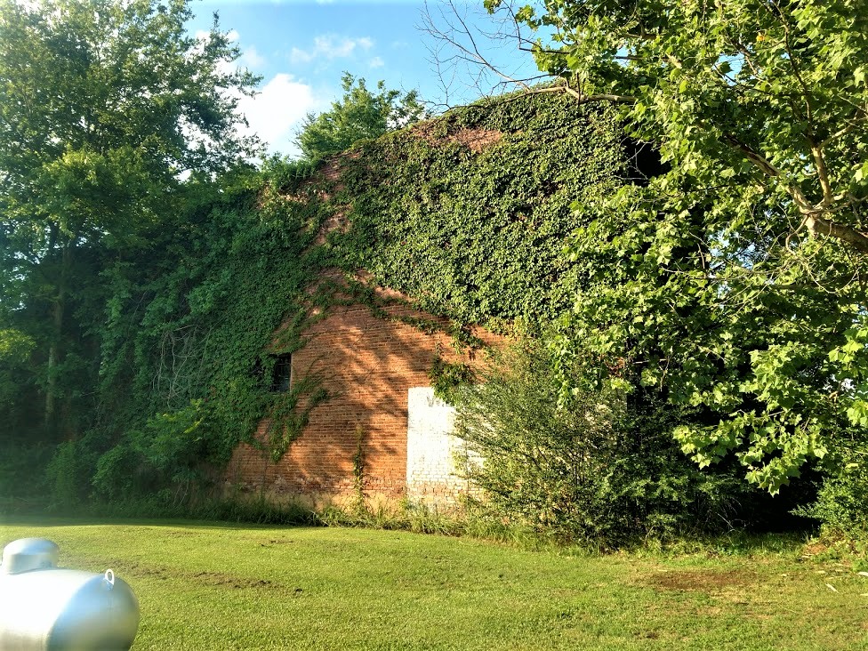
Also located in Union Springs was this Log Cabin Museum. From the historical marker: "Early settlers of this area cleared land and built their first homes of logs in the 1830's. This cabin was built by Rueben Rice Kirkland (1829 - 1915) about 1850. He and his first wife had ten children while living in the log home.

"At one time an additional bedroom and chimney were on the right side, and the back porch was closed in for cooking and eating. A small log kitchen stood a few feet from the back and was later converted to a smoke house. The milk house beside the well was on stilts to protect butter and milk from animals.

"In 1981 the Bullock County Historical Society moved the cabin into Union Springs from its original site at Stills Cross Roads in Southern Bullock County and restored it as a museum."


If you look at the very first photo at the top of the blog, you can see that this new location of the cabin is off to the side of the Old City Cemetery, also known as The Confederate Cemetery. The historical marker reads: "Micajah Norfleet Eley donated land in 1849 for the Baptist Church and an adjoining public cemetery. The oldest cemetery in Union Springs, it served the city for 36 years. The Confederate Monument at the center (seen in the top photo) was unveiled at the intersection of Prairie and Hardaway Streets on March 29, 1895 by the Ladies Memorial Association. In 1973 it was moved to its present location.


"Locally known as the Confederate Cemetery, it includes the tombstones of some twenty-two Confederate soldiers. Below the Confederate soldiers' grave sites is a marker which reads: "Union Prisoners of War, 1861-1865, Victims of Plague."


US-82 eastbound over into Barbour County, the next geocache (GC2MY21) was a quick roadside stop at another historical marker. There wasn't anything to see there. Just the historical marker for the Election Riot of 1874 which read: "Near here is Old Spring Hill, the site of one of the polling places for the November 3, 1874 local, state, and national elections. Elias M. Keils, scalawag and judge of the city court of Eufaula, was United States supervisor at the Spring Hill ballot box. William, his 16-year-old son, was with him. After the polls closed, a mob broke into the building, extinguished the lights, destroyed the poll box and began shooting. During the riot, Willie Keils was mortally wounded. The resulting congressional investigation received national attention. This bloody episode marked the end of Republican domination in Barbour County."

Crossing the state line into Quitman County, Georgia, I quickly exit the bridge and turn back towards the reservoir for my next geocache (GC8M6AW). To the right just outside the photo below is the US-82 bridge which crosses over the lake. This little path heading down to the water is what remains of the old road that you used to drive between Alabama and Georgia before the Walter F. George Lock and Dam was built in 1962. Now it sits underwater.


Our last two geocaches were in Randolph County. The first was a quick roadside park and grab just east of the town of Cuthbert (GC7EV1G). The second was in the town of Shellman, Georgia (GC887JW). Originally called Ward Station, Shellman was established in 1883 and named after Major W. F. Shellman, who was the traffic manager for the Central Georgia Railroad. This was the Shellman Railroad Depot.


There's also these muraled silos in Shellman that portray the history and scenes of Shellman's past.


The next county over is Terrell and that's where we'll be staying and working. Time to settle in and relax after a long road trip. I hope you have enjoyed these last four days traveling along the rural backroads and byways of this great country of ours. And if I have inspired you to get off the Interstates and onto the scenic roadways, leave me a comment and let me know.

To follow along on our travels and keep up with my latest blogs, you may do so here of course. But also by using you favorite of these social media platforms: FacebookMeWeGabRedditParlorTwitter, and Instagram. These all link directly to my profile. Again, please feel free to comment and / or share.

Saturday, July 24, 2021

2019-07-21: Geocaching the Rural Backroads to a Historic Church, an Abandoned Cemetery, and the First Hilton Hotel

Hello friends, geocachers, travelers, and those who may have found me by accident. On this day it's another of my long 300+ mile Sunday drives from home base in Central to work base in North Central Texas. Not a whole of to see today, but what I did see was historic as well as a sad forgotten cemetery. And you probably at one time or another stayed a night in this mans hotel. This particular building was his very first hotel. As always, the GeoJeep Travel Bug passenger seat is open. So hop on in and let's go for a drive.


Well the first group of geocaches weren't anything really interesting or or brought me to any historical place. They were just some roadside very rural backroads caches. So I thought I'd take a drive through the countryside to see if I could find them. The first one hadn't been found since February of 2016. I couldn't find it and it still hasn't been found (GC1J29N). Probably long gone and should be archived.

The next one hadn't been found in two years (GC25RMW). It was a regular sized cache and also obviously missing. I had a replacement in the GeoJeep, so loaded with some swag for kids and a logsheet and placed it there. Three more quick backroads caches and then get back to civilization (GC1G34Y, GC21XWY, GC3GVFW).

Making it to Lampasas, I've been wanting to get this next geocache for a while but there has always been muggle members in attendance. Today I got lucky having spending some time on the rural backroads. The services are over and nobody is around. St. Mary's Episcopal Church (GC500RZ) was built in 1884 of native limestone. It is the oldest church in the area still in use. Modeled after a gothic church in Rugby, England and birthplace of W.T. Campbell, pioneer communicant. The interior decor, including the oak alter and pews, are original.


Continuing up the road to the town of Early, Texas, I just had to take a photo by the town sign. I suppose this is one place that you don't ever want to be late to! Before leaving town, I make a stop at the picnic area up the road for another geocache (GC7ZWE2).


Arriving in the town of Cisco, Texas, I first head towards the "Hidden Cemetery" on the eastside outskirts of town (GC3J2RT). The cemetery is commonly referred to the Central Methodist Cemetery, although there is no sign indicating that and the cemetery is no longer maintained. The FindAGrave website shows there to be 19 buried here dating back to 1903 with two unknown dates. It is sad to see the neglected condition of these forgotten resting places just off the roadway. Many people pass by every day and not even realized they're there. Maybe one day some local historians or Boy Scout group could clean this cemetery up and erect a sign.


Back in Cisco, I find my next geocache at a Union Pacific caboose (GC7D6EM). A look inside one of these old train cars gives one a glimpse into the life of a railroad workers life away from home. It's gotta be a rough life working and living on the rails.


An unexpected surprise and one of those reasons I like geocaching are the other locations and bits of history nearby that they also bring you to. Most everyone is familiar with the name Hilton Hotels. Next to where the caboose was is the Old Mobley Hotel built in 1916 by H.L. Mobley. During Cisco's oil boom in 1919, Mobley sold his hotel to a 32-year-old ex-legislator and banker from New Mexico by the name of Conrad Hilton. On the night of the purchase, Conrad Hilton "dreamed of Texas wearing a chain of Hilton Hotels." While Hilton did sell this hotel in 1925, he continued on to becoming the "World's Foremost Innkeeper."

This building continued to be used as a hotel for many years later. It was made a Texas Historical landmark in 1970. Conrad Hilton passed away in 1979. The people of Cisco, along with the Conrad N. Hilton Foundation, restored and redeveloped this area as the Conrad N. Hilton Memorial Park and Community Center. It was dedicated on October 13, 1984.


Also located within the ground of the park, is this old clock from the former First National Bank of Cisco. It was presented to the Conrad Hilton Center on its 20th Anniversary on 2006.


So that was it for today. By this time it was 5:30 PM and I still had almost 2 hours of driving to get to work base in Munday, Texas. Plus grab a bite to eat and stop by the grocery store and get food for the week! Thanks for riding along with me. I hope you enjoyed the step back into time. Until next week, happy travels!

Sunday, June 13, 2021

2019-07-14: Geocaching Through Texas Ghost Towns, Cemeteries, Abandoned Places and a Train Depot

Welcome back to another episode of my Sunday 300+ mile drive from Central to North Texas while Geocaching through ghost towns, cemeteries, abandoned places, and history. Oh, and a great "Santa Claus Bank Robbery" story too! The passenger seat of the GeoJeep is open so climb aboard and let's go for a backroads roadtrip!


My first stop was just down the road and a quick park and grab cache (GC288JF). Then another quick stop in the old downtown of Lampasas (GC23Z9K). Good thing it's a Sunday morning cause this one is probably harder during the week with activity of muggles around and about. Driving north on US-183, I stopped for two geocaches at the Goldthwaite City Park (GC7VARK, GCTPY1).

Next up was the ghost town of Democrat Community (GC333E9). From the historical marker: "Although settlement of this area dates to 1878, this graveyard was not established until the turn of the 20th century. The earliest documented grave is that of one-year-old Lee Ella Deen, daughter of W. F. and M. L. Deen, who died in November 1904. In February 1905, J. L. Chancellor deeded the surrounding three acres of land to the citizens of the Democrat and Rock Springs communities for use as a public burial ground. Among the early graves in the cemetery are those of a number of infants and children, victims of the influenza epidemic that raged worldwide in the early 20th century, and veterans of the Civil War, World War I and World War II. A reflection of area history, the cemetery remained in use at the turn of the 21st century."

The church across the road from the cemetery is used as a community center now by the few remaining residents of the Democrat and the Rock Springs Communities.


Driving further up into the town of Comanche, I arrived for my next geocache at the old train depot (GC6H0EC). Comanche was established in 1858, when Captain John Duncan offered the county 240 acres on Indian Creek as a site for a county seat. The commissioners' court accepted the donation, and Ransom Tuggle was authorized to lay out the townsite. T. J. Nabors built the first house. The new town replaced Cora as county seat in May 1859. The first courthouse was a "picket house"—a structure of logs cut and split on the ground, set vertically in a ditch, and covered with boards also made on the ground. The post office was established in 1860 and a newspaper, the Comanche Chief, began publication in 1873. The town, a supply base for Texas ranches during its early history, was incorporated in 1873.


By 1892 Comanche had 2,500 residents, the Fort Worth and Rio Grande Railway, a daily stage, and numerous businesses. By 1915 the population was 4,500, and the town was a flourishing farm-market center and transportation center. Over the years the population would fluctuate down to as few as 3,415 and back up to nearly 4,500 again.

This geocache was a 2-stage multi-cache. I obtained clues at the train depot to figure out the final coordinates of the cache container which was located at the town's Oakwood Cemetery. When Captain John Duncan this land to establish the county seat, he specified sufficient portions be set aside for a graveyard, churches, and schools. A cemetery of about 6.5 acres was established and named Oakwood for the impressive oak trees growing on the site. The earliest marked grave is that of one-year-old John Neely, who died in January 1861.

The one grave that caught my eye was of M.R. (Boss) Greene (10-14-1843 to 5-12-1877). He was a Deputy U.S. Marshall who pursued  Dee and James Bailey for passing counterfeit quarters in Comanche. After a 10-mile chase, he captured and disarmed the brothers. Catching Greene off guard because of an unruly horse, one prisoner took Greene's rifle and shot him. He returned fire with his hand gun but was fatally wounded in the exchange. The prisoners escaped only to be recaptured and hanged on a live oak tree here in the cemetery where Greene is buried.


The next geocache was at the Amity Cemetery (GC2YQ7R). From the historical marker here: When 14-year-old Charles Farley died in Feb. 1878, his parents buried him near their farmhouse, as this frontier locality had no cemetery at the time. Three months later Fannie Nichols (1875-78) died and was buried nearby. The Farleys then donated an acre of land as a community graveyard. The neighbors built an adjacent brush arbor for funerals and general gatherings. In the summer of 1878, Baptists organized a church, naming it Amity (friendship). Before erecting their own buildings, Baptists and Methodists held services in the brush arbor or at Amity School (1 mi. NW).

William H. Lindley (1840-1913) bought land south of the Farley Farm in 1885. When new surveys placed the cemetery on his land, Lindley deeded the burial ground to the public. Later his son-in-law, George Brown, gave an additional acre to be used if needed. A large tabernacle with permanent fixtures replaced the brush arbor and was used for funerals until 1938 or 1939, when it was severely damaged by a storm. Free-will donations have maintained the cemetery since 1951. A "First Sunday in June Singing" which Amity Baptist Church originated in 1897 now serves as an annual memorial day and homecoming. By 1978 Amity Cemetery has nearly 400 graves.

On the way to my next stop, and one of the things I like about driving the backroads, was this unexpected picturesque scene of the giant hay wheels sitting on this green pasture. Contrast with the blue sky and white clouds I just had to stop and capture the photo.


Up US-183 north of Rising Star, Texas was this abandoned building. I couldn't find out anything about it and couldn't decipher the name on the front. I also couldn't find the geocache on the side by the tree either (GC5M0MG). Looks like it may have been a store or gas station. Someone even suggested it looks like it could have been a post office. Got a lot of stuff stored inside now.


Also nearby is the Romney Lutheran Cemetery geocache (GC1HMM2). It's a small rural cemetery with less than 100 interments. The earliest known marker dates back to 1901. The town of Romney was established in 1880 when former West Virginian J.W. White arrived and named the community after his former hometown. The community was granted a post office in the early 1890s which remained open through 1931. Romney had always been an agricultural community, primarily cotton. At the turn of the 20th Century, it had most essential businesses as well as a school. A boll weevil infestation in 1914 curtailed growth although it limped along into the 1960s when it still had a gas station and two stores. The 1940 population was given as 40 residents. A slow decline drove this number down to a mere 12 by the 1980 census - where it has remained.


To the east of Romney was the Long Branch Church and Cemetery geocache (GC1KEEB). Formerly organized on July 16, 1885, the Long Branch Baptist Church held its first worship services in an old schoolhouse on land donated by R. B. Covington. The thirteen charter members were served by W. B. Cobb, the church's first minister, until August 1886. Missionary pastors continued to hold monthly services over the years. The congregation, which built its first sanctuary on this site in 1905-06, has provided significant service to the Long Branch Community and the surrounding area throughout its history. The cemetery has nearly 700 interments dating back to 1882.


Then there was also the Pleasant Hill Baptist Church and Cemetery (GC7G2XZ) near the town of Carbon. The few original charter members met in the old Pleasant Hill Schoolhouse in 1892 and organized the Pleasant Hill Baptist Church. Although the first church structure, built in 1905, was destroyed by fire later that year, another was erected in 1906. A new structure was also built in 1945. Several pastors of this church have also held eminent positions at institutions of higher learning in the area. This congregation has remained active in community and mission programs. The cemetery has just over 300 interments and dates back to 1904.


Heading back towards US-183, near the intersection is a TXDOT sign which displays the distance back to the town of Carbon. There's also a geocache near the sign (GC12CTF). I'm glad someone at TXDOT has a sense of humor for the properly distanced placement as well as the geocacher picking this spot to hide a cache. Now I'm thirsting for a carbonated beverage!


My second to last stop of the day was another cemetery geocache in Cisco at the Oakland Cemetery (GC3M5V5). With over 7500 interments located in this cemetery dating back to the 1870's. There are two that I want to bring to your attention: Sheriff George Emory "Bit" Bedford and Deputy George W. Carmichael. They were mortally wounded during what was called the "Santa Claus Bank Robbery" of 1927. Around noon on December 23, 1927, four men dressed up at Santa and attempted to rob the First National Bank of Cisco, Texas. At the time it was one of Texas' most infamous crimes and led to the largest manhunt in state history.

Because of the numerous bank robberies that took place in the recent months, the Texas Bankers Association announced a $5,000 reward for anyone shooting a bank robber during the crime. So when a bystander managed to escape early during the robbery and shouted out into the streets to get the attention of law enforcement, that also attracted anyone and everyone with a gun to assist in taking down one of the four Santa's. There is more to this story, though a quick read, and I encourage you to click the link in the previous paragraph and read the entire account at the Texas State Historical website. You'll be glad that you did!


Continuing north a couple miles out of Cisco, I spotted a cemetery sign and had to investigate further. This small unkept cemetery was called Reagan Cemetery and according to the FindAGrave website contains 14 burials. Though I don't know why it called Reagan as there are no Reagans' buried here. Nor could I find any information about a town or community in the area called Reagan. The oldest is dated 1879. There wasn't a geocache here, so I hid one myself (GC8BNM4) to bring others to this forgotten cemetery.


So that was it for stopping. It was already after 5PM and I still had 100 miles of driving to go. Along with getting a bite to eat, going to the grocery store so I have lunch for work tomorrow, etc etc. Thanks for riding along and I hope you come back again for another geocaching adventure.

Saturday, April 24, 2021

2019-06-19: Roadtrip Back to Texas Day 2 in SC, GA, and AL Finding History, Old Cars, Trains, Ghost Town and a Tragic Story

WOW, Busy day today! I woke up bright and early this morning ready to go on Day 2 of this Geocaching roadtrip from North Carolina back to Texas. I didn't get off work yesterday until just after noon, so it was a late start getting going. I only made it down into South Carolina. It's Wednesday morning and there are lots of counties and caches on the agenda. I gotta start the new project in Texas on Monday morning. So hop on in the passenger seat and let's hit the road!


After checking out of the hotel in Spartanburg, I drove down I-85 to Greer and my first geocache for Spartanburg County. "Easy Wood's"  is a virtual geocache (GCG9YP) for Woods Chapel Methodist Church and Graveyard across the highway from the BMW plant. Fun fact for the next time you're on Jeopardy or something... what's the difference between a graveyard and a cemetery? A graveyard is next to a church whereas a cemetery is by itself. The Rev. Henry Wood, for whom the church is named, was a Revolutionary War soldier who lived from 1756 to 1843.

Over in Greenville County was a quick and easy little multi-cache (GC2370V) that I had not seen before. A multi-cache consists of at least a stage one or multiple stages to get clues for the final location. This stage one was a travel bug dog tag attached to a tree behind a shopping center. The travel bug code had two numerical digits which you use to substitute into a new set of coordinates which take you to the final location for the real cache. The bonus for this one was that not only do you get a cache find but also get to log a travel bug discovery.

Then a quick park and grab cache for Pickens County (GC4W54R). Also located in Pickens County is Clemson University. There I made a stop for a virtual cache called "Death Valley" (GC1989). There were several different geocaches on campus. However I only made time for just this one. Clemson's Memorial Stadium has the nickname Death Valley because it's view of the cemetery on the hill before the upper decks were constructed.


Driving on down US-123 into Oconee County, there was another quick parking lot cache find to claim that county (GC3C0ZD) and my last for South Carolina.

Crossing the Tugaloo River into Stephens County, Georgia, I stopped soon thereafter for my next geocache at a historical marker. The "Old Tugaloo Town" (GC7TCX9) historical marker reads: "North of this marker, in the center of the lake, once stood and important Indian town. The area now marked by a small island was settled around 500 A.D. and occupied by Cherokee Indians around 1450. Traders were coming to the town by 1690.

"In 1716, while Col. Maurice Moore treated with Charity Hague, Cherokee Conjuror, a group of Creek ambassadors arrived. The Creek Indians, supported by Spain and France, wished to drive the British from the Carolinas, in the Yamassee War. The Cherokees killed the Creek ambassadors and joined the British. By 1717, Col. Tehophilus Hastings operated a trading center at Tugaloo where gunsmith, John Milbourne cared for Cherokee firearms. Indian agent, Col George Chicken visited Tugaloo in 1725 and described it as "...the most ancient town in these parts.

"Tugaloo remained a principal Cherokee town until destroyed by American patriots fighting these allies of the British in 1776."

Slowly making my way westbound, the next county was Habersham County. I stopped in the town of Cornelia for my next geocache at the historic train museum (GC3QGWC). The historic Cornelia Train Depot was first built by the Southern Railway Company in the late 1880's, soon after the town was founded. The railroad depot was originally called Blaine Station for the Republican presidential candidate James Gillespie Blaine. When the first charter of the town was secured by the attorney representing the railroad, Pope Barrow, the name was changed to Cornelia in honor of his wife. The official date of incorporation was October 22, 1887.

The original terminal was damaged in 1910 in a fire, and rebuilt in 1914 to its current appearance. This large passenger and freight station was once the home to two rail lines The Blue Ridge & Atlantic Railroad (also known as the Tallulah Falls Railway) and The Georgia Air Line Railroad, now known as Norfolk Southern. This depot is the symbolic and historic heart of Cornelia and in fact the town's first boundaries were set at one half mile increments in all directions from the depot. Today this depot serves as a railroad museum filled with relics from the days when the railroad ruled, it is also a great place to sit and enjoy the passing trains roll by.


Standing outside the train depot is the 7ft tall Big Red Apple monument. The pedestal it rests on is 8ft tall. The monument was constructed in 1925 and donated by Southern Railway to celebrate the annual festival of the many apples grown in the region.


Driving south on US-441, I crossed over into Banks County and a geocache right at the historical marker at the county line (GC7ED1F). The marker reads: "This line, sometimes called “The Four Mile Purchase Line,” was the boundary between Georgia and the Cherokee Nation from 1804 to 1818. It was established when Georgia bought a four mile strip from the Indians so as to take in Wofford’s Settlement on Nancytown Creek. James Blair was agent for the government, James Vann and Katahahee for the Cherokees. It formed the boundary between Jackson Co. and the Cherokees; later Franklin Co. and the Cherokees, and is now the line between Habersham and Banks Counties."

Back up into White County, I get the "Train of Thought" geocache (GC5PBVQ) for another county at the Mt Yonah Book Exchange. There you'll also find this old railroad train narrow gauge engine.


And then a quick stop for the cache and scenic views at the Popcorn Overlook (GC1F76H) in Rabun County in the Blue Ridge Mountains.


Driving westbound on US-76, I make a quick park and grab stop for Kelly's Bridge (GC34MR8) to pick up Towns County. Followed by two more quick roadside park and grabs in Union County (GC6E5W2, GC72R98), another in Fanin County (GC7YT9F) and one more in Gilmer County (GC3R4BH).

Down in Pickens County, I stop for a virtual geocache (GC7442) at the Zell Miller Mountain Parkway monument. Dedicated in 1986 to the "strong character, integrity, and moral fiber of the people of Appalachia are exemplified in this native son of Georgia's mountains, Zell Miller has dedicated his life to aiding his fellow man. Scholar, author, businessman, teacher, champion of developmental highways, legislator, serving as Lieutenant Governor longer than anyone in Georgia history."


And then there was the "Bomb's Away" geocache in Bartow County (GC50RGA). Not sure why someone would have this setup in their front yard, but when you think you've seen it all... expect the unexpected!


Just down the road from the bomb, is "Old Car City USA, the World's Largest Old Car Junkyard" that has been here since 1931. (GC46W33) I couldn't find the cache that was hidden. And since it was closed, I couldn't go exploring the 6 miles of trails through the woods full of old cars. Not that I had time to do so anyway! But it would be fun to get back here one day to do so. But just what they had out front and peaking through the fence and windows inside was worth the stop.


Quick park and grab caches in Floyd (GC65626) and Polk Counties (GC27Z53) and I was heading for the state line and into Alabama.

My first stops in Alabama were for Cherokee County where I found two geocaches. Driving west on US-278, I took a side road and arrived in the town of Spring Garden for my first cache (GC2583K). Spring Garden was originally named Ambersonville after one of the early families that settled the community. A post office was established in 1842 as Liberty and changed to Spring Garden in 1844. The Selma, Rome, and Dalton Railroad began rail service through the town in 1870. The line later became part of the Southern Railway and was abandoned in the 1970's.

This building here was last known as the W.L. Westbrook General Merchandise Store. Constructed in 1878, it was first known as the P.H. Savage General Merchandise Store, then T.F. Stewart General Merchandise Store. William Lester Westbrook died in October of 1981 and can assume that the store closed around that time period. The second photo I found in the Library of Congress database looks to be from the late 1980's or early 1990's and the store is already abandoned. (The photo I took is from the post office side. The street view is completely covered in vines!)


(photo:  Library of Congress)

The other geocache in this county was a few miles away. The Goshen United Methodist Memorial Park (GC49R24) was established by members, relatives, and friends after a tornado destroyed the church on Palm Sunday, March 27, 1994.

On this Sunday morning, 20 children had begun the service by marching around the sanctuary waving palm branches while the congregation sang the hymn: "Tell me the stories of Jesus." The worship service began with Jesus' triumphal entry into Jerusalem, and was to end with remembering His tragic death on the cross. At approximately 11:30, a tornado with winds up to 250 mph, and moving at a speed of 55 mph descended upon the church. The edge of the half mile wide storm caused a window to break, and within four seconds the building exploded propelling the congregation into literally living the Holy Week story of joy, suffering, death, and resurrection.

Jehovah Jireh, the Lord will provide, had just been sung when the winds blew the roof and the south wall to the north, trapping, injuring, and killing many worshippers. For two hours, persons assisted in the rescue efforts freeing those trapped underneath the debris and treating the injured. By 1:00, four hundred volunteers had arrived to help. Due to the heroic work of many rescue and medical workers, as well as unexpected helpers, 126 people survived. Of the twenty killed, six were children. Those surviving gave remarkable stories of experiencing God's presence and sustaining power in the rescue efforts and through the hard days that followed.


Driving up into Dekalb County, I stopped at the Lebanon Courthouse for a virtual geocache (GCB0CE). The historic courthouse was constructed during the 1840's when Lebanon, the county seat of Dekalb County, was a thriving community with inns, taverns, and government offices. This building remained in use as a courthouse until 1876, when the stagecoaches serving Lebanon gave way to progress. The county seat was then moved to Fort Payne, where railway service was available.

By the time I got here the sun was already setting behind the building making it hard to get a decent photo.


Finally it's getting to be 9:00 pm by the time I get to Scottsboro, Alabama in Jackson County. I grab one last geocache (GC6F458) in a Walmart parking lot to claim the county. Those are about the only caches I want to find in the dark, under a street light!

Well after 15 hours of driving and caching, I'm ready for the hotel! That's it for today. Let's get some sleep and start again early tomorrow morning. I hope you come back again and ride along with me. I'm out... ZZzzzz....

Saturday, March 20, 2021

2019-05-27: Roadtrip Day3! The North Carolina County Challenge: Finding an Old School, Civil War History, BBQ, and Railroad Museums

So today is Day 3 and the last day of my holiday weekend roadtrip geocaching around North Carolina to try and complete my caching county map. Unfortunately though, like I said in Day 2's blog, I had to turn the corner and start heading east before I was able to get all the counties. But I still have more to get to today as I travel east along the south-central part of North Carolina. 

Let's hit the backroads and drive through North Carolina history. The passenger seat is open on the GeoJeep. Climb in and see what we can find... 


After checking out of the hotel bright and early this morning, I drove up to Burke County for my first geocache (GC6GJMA). This one was hidden by a geocacher outside her own house. Problem was that she moved away and it doesn't look like the house has been occupied in a while. Probably won't last much longer.

Moving right along into Alexander County for a quick parking lot cache at a grocery store (GC7MF94). Going east on I-40 into Davie County, I exit on US-64 to the town of Mocksville. I find the quick cache (GC467NN) near the fire station and keep going.

Entering the town of Lexington in Davidson County, I stop in the town square for a look back into history. The name Lexington was given to a crossroads settlement that consisted of a store, a tavern, and a few houses in 1775 shortly after the first skirmish of the Revolutionary War in Lexington, Massachusetts. The town was officially incorporated in 1828. The first Davidson County court house was completed in 1858, and was the only masonry building in the county at that time. The courthouse was used as barracks for Yankee soldiers in the civil war during which was damaged by fire in 1865, and rebuilt in 1867.


Lexington is also known for its BBQ (GC6C85). North Carolina has a long history regarding barbecue. The Spanish brought hogs to the Americas in the 1600's. As the pigs took over, pork became the meat of choice. Over time, the barbecue methods from around North Carolina converged into the style that’s known today as Eastern-style barbecue, a thin tangy sauce made with vinegar and red pepper flakes. Once the meat is smoky and tender, it’s chopped up and mixed with more of the vinegar sauce. Eastern-style barbecue is served by the plate or on a bun, usually accompanied by white cabbage and mayonnaise slaw. This is the original style of North Carolina bbq.

Sometime around World War I, an East-West split started to happen in the towns and cities of the Piedmont region west of Raleigh. There, pitmasters started using only the shoulder of the pig and vendors started adding ketchup or tomato paste to the traditional vinegar sauce. The style grew in popularity throughout the Piedmont region. It especially took hold in Lexington, which became the center point for Western-style barbecue. Barbecue is big in Lexington. The town of just under 20,000 hosts an annual barbecue festival that draws upwards of 175,000 attendees.


One more quick roadside geocache (GC46YJ8) in Davidson County at a historical marker for the Yadkin College which opened in 1856. It began as the Yadkin Institute, a high school for young men by the Methodist Church. It was re-chartered by North Carolina as Yadkin College in 1861.

Then followed by a quick roadside geocache (GC1V14A) in Rowan County.

Moving south into Stanly County was another historic old school building (GC15ENE), pictured at the top of this page and the next two. Pfeiffer University is a private university located in Misenheimer, North Carolina, established in 1885. The school first began its operation on the edge of Hudson, NC and was called Oberlin School, and was later endowed by Mrs. Mary P. Mitchell and was named in her honor as the Mitchell School. A fire destroyed the original school in 1907, and it was then moved to Lenoir. The new location proved to be inadequate and was relocated in 1910, to Misenheimer.


The Mitchell School began awarding high school diplomas in 1913, and began offering junior college classes in 1928. In 1934, the Pfeiffer family of New York City, gave several generous financial gifts to the school. The school changed its name to Pfeiffer Junior College, after it was accredited the same year. In the 1950's, the school began offering senior level college courses, and was then accredited as a four-year college in 1960. In 1996, the college received university status, as Pfeiffer University.


On the way to my next set of geocaches I passed through Albemarle, NC. One of those always interesting roadside attractions was spotted outside Jerry's Automotive. A shortened VW Bus with the monster head and arm sticking out that reminded me of the old Ed Roth or Rat Fink CARtoon drawings. I had to stop for a photo.


My next two geocaches were also quick roadside stops, one in Montgomery County (GC1M50J) and the other in Union County (GC82RBK).

Driving down to my next geocache, I passed by this old abandoned house. It looked like it was once a nice home. I wonder who once lived here and why they abandoned such a nice house. It's a shame it's just falling apart.


The next geocache (GC4JA4H) and county comes with a ghost story. The Ghosts of Indian Rock In Anson County, about 3 miles northeast of Wadesboro there's a small bridge crossing a creek. Most people drive across the bridge without a thought of what lurks nearby, but the locals know. They know it as Indian Rock. Near the creek known as Gould's Fork Creek there is a cave that was carved by Catawba Indians long before the white man settled in Anson County. But it's what happens here that has the locals spooked. That's all I'll share with you. You can read "the rest of the story..." over on the geocache page.

Moving over into Richmond County, I had two virtual geocaches on my to-do list. "Justice Rolls Down" (GCG67R) was the virtual located in the town of Rockingham. Outside the county courthouse were three historical markers and a monument. The historical markers were for a Brigadier General, a Governor, and a U.S. Congressman. The monument honors the county's veterans who served.


The next virtual geocache (GCG67V) was located in the town of Hamlet, NC. The first building constructed on Main Street by E. A. Lackey in 1901. It once was Carsons Drugs, Hamlet Pharmacy, and then Birmingham Drug which remained in business for over 50 years until 2019. During WWII, soldiers stayed in the rooms upstairs while waiting to board their trains. In 1990 the movie Billy Bathgate was filmed here and this was used as the hotel and restaurant in the movie.


Across the street from the historic train depot was the Tornado Building. I thought it had something to do with the weather. After some research for this blog, I discovered it to be a railroad museum.

The Tornado was the first steam engine locomotive in North Carolina. Originally built in 1839 by D.J. Burr & Co. of Richmond, Virginia, the Tornado was classified as a 4-2-0 steam engine locomotive. The numbers stood for four leading wheels, two driving wheels and no trailing wheels and a total length of 50 feet including tender and box car. It was one of four locomotives delivered to the Raleigh & Gaston Railroad, the others being the Tempest, Volcano and Whirlwind.

Weighing in at six and a half tons, the Tornado was on the light side by most locomotive standards; however she pulled thirty loaded cars and routinely hauled up to 160 tons of freight on 50-mile runs between the towns of Henderson and Gaston, North Carolina. In 1840, the Tornado became the first steam locomotive to reach the state capital of North Carolina on the Raleigh & Gaston Railroad, where she arrived to gawking crowds of residents.

In the spring of 1865, the Union Army captured the Tornado when they took the North Carolina Railroad between Goldsborough and Raleigh. After much use and a gradual phase out of this model in favor of the newer 4-4-0 models, this Tornado replica was originally rebuilt in 1892 for the Raleigh Centennial Exposition. It was featured in the Great Centennial Celebration parade in October of that same year. It arrived in the Town of Hamlet in 1950 and was again fully-restored with North Carolina DOT funds between the years of 2007-2009.

The building in which it is now housed was specially-created to accommodate the Tornado. The structure also houses a 1927 Model-T, a 1930 Model-A Ford and a 1949 fire engine. Now I wish I would have checked to see if it was open so I could go inside.


In the late 1800's, John Shortridge established a woolen and saw mill along Marks Creek in the sand hills of North Carolina. In 1879, a railroad running from Wilmington passed through the area that would become Hamlet to the Pee Dee River, where it connected to a line running to Charlotte. Another railroad was being built from Raleigh through to Augusta; it was through the influence of early residents that these tracks also crossed through Hamlet. 

The Hamlet depot, the only Victorian Queen Anne style station in North Carolina, was built in 1900 for the Seaboard Air Line Railroad as both a passenger station and division headquarters. This two-story station was originally constructed at the crossing of the Raleigh and Augusta Air Line and Central Carolina Railways. Hamlet grew with the railroad, as it provided hospitality for travelers passing from New York to Florida. By 1936, Hamlet was dubbed the “Hub of the Seaboard,” with five Seaboard Air Line Railroad lines leading out from the city and about 30 passenger train departures each day. Freight trains still come to Hamlet for maintenance at the CSX Transportation Maintenance Shops.


Running out of time, I start making my way back as quickly as possible. In Moore County I find a quick roadside geocache along US-1 (GC1WYKK), one in Scotland County (GC1W6AA), another in Hoke County (GC3WBFA), Lee County (GC2QJFE), and finally Chatham County (GC7TCRR).

That is all the time I had for this weekend. Unfortunately, I couldn't make it as far west as I wanted too and had to leave those counties for another roadtrip. The other two counties in the middle, well I'm not exactly sure how I missed those. Still a good trip since just a few weeks ago when I first arrived in North Carolina I think I only had about 24-25 counties completed. And I still have some time left here. Maybe I can get those on the way back to Texas.