Saturday, February 27, 2016

2016-01-24: Cemeteries, Canyons, and History Around Crosby County Texas

Today was a Geocaching day for finding lonely caches and cemeteries around Crosby County Texas. Lonely caches are either difficult or caches that are way out of the way in the middle of nowhere and nobody wants to drive to go find them.

So today we headed east on US-82 out to our first cache at the Crosbyton Cemetery (GC5HGV5). In 1909 when James Boggs, one of the -N- cowboys became ill and was thought to be dying, Julian Bassett had the Crosbyton cemetery laid out. TJ Walling, foreman, Buck Creamer, and JP Goins did the work. However, Boggs did not die. The first person buried at the Crosbyton cemetery was Willie Oliver, eighteen month old daughter of Mrs. Laura Oliver. She was buried on the north side where a small wooden fence enclosed the grave.


Just down the road, still in Crosbyton, is the Mt Zion Cemetery and our next cache (GC54293). Developed as a burial ground for the community's African-Americans in the early to mid-1900s, many of the stone grave markers have become chipped and broken. Pieces remain, but whole sections of names and dates of deaths are missing. About 10 years ago  Doddrick Quincy, a 16-year-old Boy Scout of the South Plains Council, lead a crew of Troop 333 Scouts in restoring the cemetery as part of his Eagle Scout project. The Scouts had to find unmarked graves and try to learn who is buried in each plot. The cemetery was built by the Mt. Zion Church, an African-American church built in 1924.


Our next cache was near an intersection that had four historical signs telling about a nearby ranch, the Texas Rangers, Old Dewey Lake, and the Mackenzie Trail. Though there wasn't anything there to see or take a picture of, it was interesting reading.

Moving along to another cache (GCHRXD) at a Texas rest area along US-82. This was a fun rest area! There was a creek running along the back side with a hiking trail. Now you can't pass up a hiking trail!


Our next cache was one of those out-of-the-way lonely caches that rarely get visited. Along the way we passed by some really great views and took some pictures. We also passed by a couple of historical signs. The first was about the Leatherwood School. To summarize it read:
This area of Crosby County was settled in 1898 by the family and relatives of M.G. Leatherwood. As other families began to arrive, the need for a nearby school became apparent. As a result, the Leatherwood Common School District was created in 1912.   
The first classes held in the spring of 1913 in a one-room schoolhouse on land donated by M.G. Leatherwood, were taught by Ellsworth Ham. The location of the school was changed twice before it was moved to this site at the eastern edge of the county.
At the height of its growth, Leatherwood School employed three teachers who taught 36 students in a three room schoolhouse. The final classes were held in 1949 when the area was made part of the Crosbyton School District.
 Another historical marker we passed:
The Pansy Baptist Church was organized in 1905 to serve the residents of the Pansy community. Church services were conducted in the school building until when the congregation constructed its first sanctuary. An arbor was built on the church grounds for revival services.
After a couple of moves and rebuilds, the latest being in 1965. Through the years population dwindled in the rural community of Pansy. In 1995 the remaining members voted to disband. The church building was donated to the Mt Zion Baptist Church, an African-American congregation in Floydada. The building was moved 32 miles by 140 volunteers. 


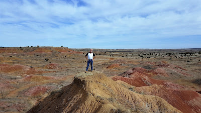
We finally arrive at our next Geocache (GCHRBA) called Cosmic View. A scenic area of the canyon and almost a year since the previous cacher logged a visit. It was definitely worth the trip though. We each took a turn for a photo and then a panoramic view.


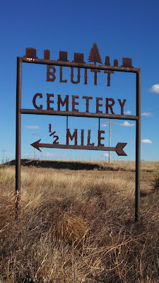
Our next stop was Red Mud Cemetery (GC4ZZ83). First known as Tap Cemetery, as the little town of Tap was about 1/2 mile NE of this site. As Redmud Creek was nearby, it later became known as Redmud Cemetery. Will Barger homesteaded this land, and was shot by a neighbor in April 1886. His wife died of TB in July 1886 and was buried by his side. The number of graves increased and in 1906 the land owners on the north and south gave one acre each for the cemetery. In 1909 a group took the care of the cemetery as a project and the day for the annual cemetery working was set on June 6, it is still observed each year.


So as we were walking around the cemetery, we spotted this odd headstone. At first glance it looks as though Ida Peterson died BEFORE she was born. But after closer inspection, it seems as though they stamped the "9" in 1948 upside down!


We found a total of eleven caches for today before heading back home to end another great weekend of Geocaching.

2016-01-23: Strange Houses, Hiking Hills, History and Cemeteries

Today was a day for Geocaching fairly close to Lubbock. Getting a late start after breakfast, we headed east over to Ransom Canyon to grab a virtual cache (GCGPZH). High above overlooking the canyon is a very unique house. It kinda reminds me of a kids Viewfinder from the one side. You can't tell from the photos below, but the side facing the lake is just a giant glass window.


A couple of houses down and across the street is this Hobbit looking house.


As we continued to cache around the lake, hundreds, maybe thousands of ducks were flying by overhead. Not sure you are able to see them flying in formation on the device you are reading this one. Hopefully you can.


After Ransom Canyon, we headed south down US-84 a few miles to the town of Slaton. There we found our next Geocache at the Slaton Harvey House (GC1EKVV). From the historical sign: The city of Slaton has historic ties to the railroad. For decades the site was ranchland until the Santa Fe Railway sought a location for a division point to service trains. The Santa Fe bought the land in April 1911, naming the townsite for rancher and banker O. L. Slaton. Passenger and freight service became central to the economy, and the company built a passenger depot and Harvey House the following year. Scottish immigrant Fred Harvey created the Harvey House chain in 1876, partnering with the Santa Fe Railway, which built the restaurants and provided space on their trains for food and supplies. Harvey provided the equipment, management and hospitality staff, including the hostesses known as Harvey Girls.

The Slaton Harvey House served efficient but elegant meals to 42 passengers at a time around a horseshoe shaped counter on the first floor, which also housed the kitchen, bakery, gift shop and manager's office. The manager and his family and the Harvey Girls roomed on the second floor. The Slaton Harvey House, a commercial and social center, operated for 30 years, briefly reopening to serve troops during WWII. The building remained a passenger depot until 1969; the railroad later converted it to a freight depot and operations center before vacating the property in the 1980's. Slaton citizens coordinated the preservation and restoration of their landmark building.


From there we drove north on some backroads to stretch our legs and do some hiking. There were a couple of caches with a high terrain rating. Sounds like an adventure! We arrived at the first area (GC4C0MZ) and I drove around the curve past it and then back again trying to figure out the best parking and approach to the top of the hill. It was an exhilarating climb with a fantastic view! So peaceful and quiet with only the sound of the wind out there.


A couple miles away on the east side of Horseshoe Canyon was the next cache (GC1K5MW) and the next hike. Slightly easier than the first one, but still an amazing view and peaceful. Only one car had passed the whole time up and back.


On our way to the next couple of caches out in the middle of nowhere, we passed by a herd of deer grazing in a field.


Our last cache for today was located at Emma Cemetery south of the town of Ralls. Emma is on that short list of ghost towns that were once county seats. Business partners R. L. Stringfellow and H. E. Hume were store owners in the Crosby County seat of Estacado, when they bought a section of land in 1890. A post office was granted that year and the name submitted was Emma - after a woman who later married one of the partners. History doesn't seem to record if she became Mrs. Stringfellow or Mrs. Hume.

The central location made Emma a consideration for the county seat and since residents of Estacado were already drifting to the newer community, an election was held in the Fall of 1891. Emma squeaked through by a six-point margin (109-103). The residents of Estacado moved the courthouse and other prominent buildings to Emma and the town prospered for awhile. By 1910 there was a population of 800 and Emma had all essential businesses including a bank and newspaper.

Emma's future seemed bright up until it was bypassed by the railroad in 1910. The shoe was now on the other foot and Emma lost out to the new town of Crosbyton in an election held in September of 1910. This election was also close (198 to 120) and soon the former townspeople of Estacado and Emma were moving again - this time in an organized exodus that consisted of steam engines, mules and most of the male population. The former courthouse was dismantled and taken to Cedric and the next year the Emma post office moved to Ralls. Today only the historical marker is left.

History lesson is over. Now back to Geocaching. Cemetery caches are one some of our favorite caches to find. This one happens to be a virtual cache (GCHA69). Now since we've been Geocaching, we must have been to a hundred or more cemeteries. THIS is a first! Every headstone we've ever seen said "Died", "Death", or simply "D". Poor Tommie Horrell had the truth told about him. He was MURDERED on Jan 5, 1894 at the young age of 24.


While we ended the day with only ten caches, they were really good quality caches. Unusual houses, history, hiking, a cemetery... this is why we like this game! Where do we go to tomorrow? You'll just have to come back and see!

Friday, February 26, 2016

2016-01-17: Geocaching Along the Texas and New Mexico Borders

So today was a Geocaching day to pickup where we left off yesterday. Picking up new counties and Geocaches of interest along the West Texas and New Mexico borders. We headed west on US-62 down into Brownfield, TX and turned onto US-380 westbound in Terry County.

Before arriving at our first Geocaches for the day, I saw a historical marker on the side of the road. As we are driving around exploring new areas, not only is Geocaching a good way to find places of interest but also the historical markers. So we pulled over to find that the building before us is what remains of the ghost town of Tokio. There were two towns in Texas that went by the name Tokio. (correct spelling) During WWII, the other changed it's name to Wiggins.

This town kept the name. The first school was built in 1911. Tokio was granted a post office in 1912. In 1929, Tokio had a population of only 15. It's record high population was in the 1940's with 125. Over the years, larger school buildings were constructed until the school finally merged with the Brownfield School District after the 1945-46 school year. There are still a few residences in the area, but the town officially folded and all that remains is the old school building.

Stopping for three quick caches in the town of Plains, we continued west on US-380 to the state line. There were several caches located near the state line. The most interesting was a virtual cache (GC41C6) at the memorial for the founder of the now ghost town of Bronco, TX.

At the age of 13, Herschel Robert Field saddled his horse, left his home in Batesville, AR and braved his way through Indian territory to become a cowboy in West Texas. In 1891, he began working for the T Fork Ranch in Wichita County, Texas and later the XIT Ranch. He eventually decided to move to Arizona, but along the way he was attracted by the grazing lands in Western Yoakum County. Field saw this area as a place where a cowboy with limited means might start his own ranch. In 1903, he purchased some land and started a store right at the Texas-New Mexico line.

Soon after he opened the store, he applied for the rights to a post office. He secured the post office from the agency in Washington, but they rejected the name. A traveling salesman suggested Bronco after seeing a cowboy ride a wild horse. And that's how the town got it's name. Settlers began congregating around Field's store in Bronco. By 1912 the population grew to about 25. At it's peak in the 1960's, the towns population grew to 180. Today there are only about a dozen residences scattered about and all the businesses have closed.


Continuing west on US-380 and into New Mexico, we entered into the town of Tatum. There was a metal fab shop there that made all kinds of sculpture and signs and we just had to pull over for a couple of pictures.


We found a few Geocaches in Tatum and turned north on Hwy 206 picking more caches every now and then. Now most of the time, you tend to find unusual out of the way sites because another Geocacher has placed a cache nearby causing you stop. But along this highway, we found one of the Roswell alien crash sites. Well maybe not really, but there's a farmer with a sense of humor!


Local wildlife.
One of the caches along the way was inside a 100 Grand Candy tin (GC5JBT5) at the entrance to the Candy Oil Field Service Treating Plant. And of course with Candy being named Candy and the company being named Candy and the cache having a candy theme. OK, well you get the idea...


We continued up Hwy-206 to Milnesand and turned back east on Hwy 262, eventually picking up Hwy 114 back to Lubbock. Overall we found 17 caches and a few more new counties. But best of all we had a nice drive through history.

Thursday, February 25, 2016

2016-01-16: Geocaching Through History in West Texas

Today's Geocaching adventure allowed us to learn some history, view some great scenery, pickup some new caching counties, and just having some fun in West Texas. It was still kinda cold out, but by heading southbound at least there wasn't any snow on the ground.

So we headed down US-84 to our first stop in the town of Post in Garza County. I'm sure we have all heard of Post Cereals. And usually when I thought about Post Cereals, I think Battle Creek, Michigan. However Charles W. Post, internationally known creator of Post Cereals, advertising genius, inventor, innovator, and founder of Post City in 1906 had other ideas. Through the purchase of the Curry Comb Ranch and adjacent land approximating 225,000 acres, he began his dream of building self-contained model community of towns and farms.

Mr. Post financed, supervised and built the town without profit to himself. Settlers were offered ownership of business or farm sites far below cost. Mr. Post planned the community of debt-free private ownership in every field of endeavor, and sought to make his vision true to its purpose.

I found his story very fascinating. And our first Geocache brings us to the Old Post Sanitarium (GC509R3). Built in 1912 by C. W. Post's Double U Company and was the first hospital in this part of West Texas. The finest facilities of the day included x-ray laboratory, operating and sterilization rooms, nurses training, diet kitchen, all rooms private, and steam heat.

It is now a museum for all things pertaining to West Texas. But two rooms are dedicated to the original hospital setting and C. W. Post's office furniture from Michigan.


Next stop was a cemetery cache (GC5G98H) at the Terrace Cemetery on the east side of Post. After Post, we headed south on FM669 down to a town called Gail in Borden County. At the Gail Cemetery was another cache (GC5KWZH). This cemetery dates back as early as 1891.

Also located in Gail was the Borden County Courthouse and the location of our next Geocache. The Coyote Hitching Post (GCPJ6C) cache looks like it just might be an original hitching post from many years ago!

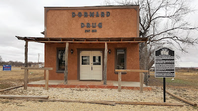
Right across the street from the courthouse, was the Dorward Drug Store. David Dorward arrived in Borden County in 1892. He opened the drug store in 1901. As the town began to decline in population, Dorward Drug became the focal point of the community by providing over-the-counter medicines, refreshments, ice, and most importantly, a gathering place to hear the local and area news. When the telephone switchboard closed in 1918, the drugstore had the only telephone serving Gail and surrounding farms and ranches until the 1950's. Telephone messages received by Mr Dorward at the store would then be delivered to local residents or to outlying farmers and ranchers. The drugstore had fallen into bad shape, but was restored in 2012 when new owners acquired the land.


Continuing west on US-180, enjoying the landscaping and a few old abandoned buildings along the way, we drove over to Lamesa, TX. Our first cache in town was called The Big Show (GC22VH3). A rare drive-in movie theater, that's closed during the winter, but still in operation during the rest of the year.


There were several Geocaches in this town, but another one of our favorites besides the drive-in was a piece of historic Americana. This nostalgic statue (GC33QT6) was once the Uniroyal Tire & Rubber Gal now wears the uniform of the local high school.


So after several more caches around town, we headed out southwest of town to the middle of nowhere. But because of Geocaching we found this old Chevy pickup cab sitting in a field (GC1235H). When you come across something like that you just gotta take a photo!


We continued southwest into the town of Andrews, located within Andrews County. There we stopped for a virtual cache (GCF255) at the county courthouse. Even though it was closed being the weekend, we were able to look through the glass doors to get a peak at the 2,000,000 Kirby vacuum cleaner which was made in 1979.

Also in Andrews and another cache was the Andrews County Veterans Memorial (GC30QMV) honoring all the veterans from the county who fought in all the wars to date.


Driving north towards home, we ventured slightly west over to the Ghost Town of Shafter Lake. In 1908 the population of Shafter Lake was about 500. It has 3 hotels and a couple of trade stores. The editor of the paper advertised that there were vast fields of green lush grass and fresh water in the lake. The grass wasn't green, and the water was alkaline, because there is no outlet the water just sits there. In 1910 there was a vote on whether Andrews or Shafter Lake was the County Seat. Shafter Lake lost, and the population dwindled down to just a few families. In 1916 a tornado went through what was left and destroyed every thing except one house. It happened to be the Post Masters house (GC1B72), and his descendants live the newer house next door.


On the way back to Lubbock, we stopped for several more caches in new Texas counties. While here in Texas, we've seen plenty of oil wells. But along the way today, this was the FIRST time we saw one painted up in camouflaged!


Overall we found 17 new Geocaches, several more new counties, learned lots of history, and saw some great sites. That's it for today's adventure. We hope you have enjoyed reading our stories and following along. Please feel free to comment and let us know you were here. Also feel free to share our blog with your friends.