Friday, February 26, 2016

2016-01-17: Geocaching Along the Texas and New Mexico Borders

So today was a Geocaching day to pickup where we left off yesterday. Picking up new counties and Geocaches of interest along the West Texas and New Mexico borders. We headed west on US-62 down into Brownfield, TX and turned onto US-380 westbound in Terry County.

Before arriving at our first Geocaches for the day, I saw a historical marker on the side of the road. As we are driving around exploring new areas, not only is Geocaching a good way to find places of interest but also the historical markers. So we pulled over to find that the building before us is what remains of the ghost town of Tokio. There were two towns in Texas that went by the name Tokio. (correct spelling) During WWII, the other changed it's name to Wiggins.

This town kept the name. The first school was built in 1911. Tokio was granted a post office in 1912. In 1929, Tokio had a population of only 15. It's record high population was in the 1940's with 125. Over the years, larger school buildings were constructed until the school finally merged with the Brownfield School District after the 1945-46 school year. There are still a few residences in the area, but the town officially folded and all that remains is the old school building.


Stopping for three quick caches in the town of Plains, we continued west on US-380 to the state line. There were several caches located near the state line. The most interesting was a virtual cache (GC41C6) at the memorial for the founder of the now ghost town of Bronco, TX.

At the age of 13, Herschel Robert Field saddled his horse, left his home in Batesville, AR and braved his way through Indian territory to become a cowboy in West Texas. In 1891, he began working for the T Fork Ranch in Wichita County, Texas and later the XIT Ranch. He eventually decided to move to Arizona, but along the way he was attracted by the grazing lands in Western Yoakum County. Field saw this area as a place where a cowboy with limited means might start his own ranch. In 1903, he purchased some land and started a store right at the Texas-New Mexico line.

Soon after he opened the store, he applied for the rights to a post office. He secured the post office from the agency in Washington, but they rejected the name. A traveling salesman suggested Bronco after seeing a cowboy ride a wild horse. And that's how the town got it's name. Settlers began congregating around Field's store in Bronco. By 1912 the population grew to about 25. At it's peak in the 1960's, the towns population grew to 180. Today there are only about a dozen residences scattered about and all the businesses have closed.


Continuing west on US-380 and into New Mexico, we entered into the town of Tatum. There was a metal fab shop there that made all kinds of sculpture and signs and we just had to pull over for a couple of pictures.


We found a few Geocaches in Tatum and turned north on Hwy 206 picking more caches every now and then. Now most of the time, you tend to find unusual out of the way sites because another Geocacher has placed a cache nearby causing you stop. But along this highway, we found one of the Roswell alien crash sites. Well maybe not really, but there's a farmer with a sense of humor!


Local wildlife.
One of the caches along the way was inside a 100 Grand Candy tin (GC5JBT5) at the entrance to the Candy Oil Field Service Treating Plant. And of course with Candy being named Candy and the company being named Candy and the cache having a candy theme. OK, well you get the idea...


We continued up Hwy-206 to Milnesand and turned back east on Hwy 262, eventually picking up Hwy 114 back to Lubbock. Overall we found 17 caches and a few more new counties. But best of all we had a nice drive through history.

Thursday, February 25, 2016

2016-01-16: Geocaching Through History in West Texas

Today's Geocaching adventure allowed us to learn some history, view some great scenery, pickup some new caching counties, and just having some fun in West Texas. It was still kinda cold out, but by heading southbound at least there wasn't any snow on the ground.

So we headed down US-84 to our first stop in the town of Post in Garza County. I'm sure we have all heard of Post Cereals. And usually when I thought about Post Cereals, I think Battle Creek, Michigan. However Charles W. Post, internationally known creator of Post Cereals, advertising genius, inventor, innovator, and founder of Post City in 1906 had other ideas. Through the purchase of the Curry Comb Ranch and adjacent land approximating 225,000 acres, he began his dream of building self-contained model community of towns and farms.

Mr. Post financed, supervised and built the town without profit to himself. Settlers were offered ownership of business or farm sites far below cost. Mr. Post planned the community of debt-free private ownership in every field of endeavor, and sought to make his vision true to its purpose.

I found his story very fascinating. And our first Geocache brings us to the Old Post Sanitarium (GC509R3). Built in 1912 by C. W. Post's Double U Company and was the first hospital in this part of West Texas. The finest facilities of the day included x-ray laboratory, operating and sterilization rooms, nurses training, diet kitchen, all rooms private, and steam heat.

It is now a museum for all things pertaining to West Texas. But two rooms are dedicated to the original hospital setting and C. W. Post's office furniture from Michigan.


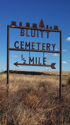
Next stop was a cemetery cache (GC5G98H) at the Terrace Cemetery on the east side of Post. After Post, we headed south on FM669 down to a town called Gail in Borden County. At the Gail Cemetery was another cache (GC5KWZH). This cemetery dates back as early as 1891.

Also located in Gail was the Borden County Courthouse and the location of our next Geocache. The Coyote Hitching Post (GCPJ6C) cache looks like it just might be an original hitching post from many years ago!

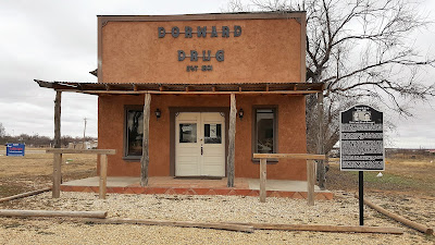
Right across the street from the courthouse, was the Dorward Drug Store. David Dorward arrived in Borden County in 1892. He opened the drug store in 1901. As the town began to decline in population, Dorward Drug became the focal point of the community by providing over-the-counter medicines, refreshments, ice, and most importantly, a gathering place to hear the local and area news. When the telephone switchboard closed in 1918, the drugstore had the only telephone serving Gail and surrounding farms and ranches until the 1950's. Telephone messages received by Mr Dorward at the store would then be delivered to local residents or to outlying farmers and ranchers. The drugstore had fallen into bad shape, but was restored in 2012 when new owners acquired the land.


Continuing west on US-180, enjoying the landscaping and a few old abandoned buildings along the way, we drove over to Lamesa, TX. Our first cache in town was called The Big Show (GC22VH3). A rare drive-in movie theater, that's closed during the winter, but still in operation during the rest of the year.


There were several Geocaches in this town, but another one of our favorites besides the drive-in was a piece of historic Americana. This nostalgic statue (GC33QT6) was once the Uniroyal Tire & Rubber Gal now wears the uniform of the local high school.


So after several more caches around town, we headed out southwest of town to the middle of nowhere. But because of Geocaching we found this old Chevy pickup cab sitting in a field (GC1235H). When you come across something like that you just gotta take a photo!


We continued southwest into the town of Andrews, located within Andrews County. There we stopped for a virtual cache (GCF255) at the county courthouse. Even though it was closed being the weekend, we were able to look through the glass doors to get a peak at the 2,000,000 Kirby vacuum cleaner which was made in 1979.

Also in Andrews and another cache was the Andrews County Veterans Memorial (GC30QMV) honoring all the veterans from the county who fought in all the wars to date.


Driving north towards home, we ventured slightly west over to the Ghost Town of Shafter Lake. In 1908 the population of Shafter Lake was about 500. It has 3 hotels and a couple of trade stores. The editor of the paper advertised that there were vast fields of green lush grass and fresh water in the lake. The grass wasn't green, and the water was alkaline, because there is no outlet the water just sits there. In 1910 there was a vote on whether Andrews or Shafter Lake was the County Seat. Shafter Lake lost, and the population dwindled down to just a few families. In 1916 a tornado went through what was left and destroyed every thing except one house. It happened to be the Post Masters house (GC1B72), and his descendants live the newer house next door.


On the way back to Lubbock, we stopped for several more caches in new Texas counties. While here in Texas, we've seen plenty of oil wells. But along the way today, this was the FIRST time we saw one painted up in camouflaged!


Overall we found 17 new Geocaches, several more new counties, learned lots of history, and saw some great sites. That's it for today's adventure. We hope you have enjoyed reading our stories and following along. Please feel free to comment and let us know you were here. Also feel free to share our blog with your friends.

Wednesday, February 24, 2016

2016-01-10: Geocaching Around Lubbock Texas

Because it was so cold yesterday, today we decided to stay local and do some urban Geocaching around Lubbock. Our first stop was to see the Buddy Holly Center and Museum. It was closed this early, but we did get to see the giant glasses (a virtual cache GC6E04) and the memorial statue (GC640VA). Buddy Holly's hometown was Lubbock, Texas and they certainly pay tribute to him.


Not too far away over at the Eastlawn Memorial Gardens, is another virtual Geocache (GCC1AB) at Buddy Holley's gravesite next to his parents. There'a another Geocache here (GC1KJJV) highlighting the supposedly haunted aspect of this cemetery. This cemetery is one of the largest in Texas with over 60,000 graves and was established back in 1892.


Also while in the cemetery and with all the snow on the trees, Candy couldn't help it but to go over to one of the trees and shake all the snow off the branches! By selecting one of the taller branches, that also meant it comes down on her head too.


Exiting the backside of the cemetery brought us out to the Canyon Lakes Park. Within the city limits of Lubbock is the Yellow House Canyon, a narrow and shallow channel. The city created a series of small dams that created a series of narrow lakes. And Canyon Lakes Park was created. There's also a series of eight Geocaches around the lake as well. And of course we can't just leave them without looking first!


From there, we drove over to the campus of Texas Tech. Since it was Christmas Break, there weren't many students still here which made Geocaching a little easier. Though most of the ones we looked for, we could not find. We did see some very nice statues.


So that was it for today. We did learn a lot about the local history. Now time to go back to the apartment and thaw out again.

2016-01-09: Geocaching Through the Snow and the Cold

OK, so the high temperature for the day is only in the 30's, there's still plenty of snow on the ground, and what are we to do but go Geocaching! There are new places to explore, new counties to get, and more caches to find.

So we start off by going east on US-82 and our first stop was the Ralls Cemetery for a cache (GC2WF1M). The cemetery was blanketed in snow, but we were determined to get to it. Having all the snow made for a very picturesque visit as well. We didn't go checking out different headstones, but they did have this huge monument of The Lord's Prayer near the cache site.


From Ralls, we continued west towards Crosbyton and then northbound on Hwy 651. Next stop was the cache at Lakeview Cemetery (GC5MA3G), followed by the cache at Forest Lawn Cemetery (GC5MCGX). The road going up through here leads into the canyon and with the recent snow makes for a good photo.


We made our way on up to US-62, west to Floydada and then back south to Ralls again. Along the way we picked up four more Geocaches, but it was just too cold and we headed back home. We got to explore a little bit of the area and pick up a new county. Hopefully it will warm up soon.


2016-01-03: Moving Day! Geocaching From Jasper to Lubbock Texas

Today was moving day! Our time here in Jasper is over and it was time to move on to the next location. Candy's next job assignment is across the state over in Lubbock, TX. Even though we're staying within the same state, Texas is a BIG state! So we got an early start this morning, heading out about 6:30 am.

We drove our usual weekend route up US-69 to Lufkin, stopping at Cracker Barrel for breakfast and then Starbucks for coffee. From there we continued north up to Jacksonville. Hey, we're back in Florida! No not really... we passed through Jacksonville, TEXAS. There, we turned onto US-175.

A few more miles up the road, we came to our first Geocaching stop in the town of Poyner. Located in Henderson County, another new Geocaching county for us. The Poyner Cemetery cache (GC1N6A2) was a quick find and once again we were on our way.


Continuing even further and our next new county needed was another cemetery cache. Located in Van Zandt County Texas, was the Cedar Creek Cemetery. There were two Geocaches in this cemetery (GC4FBJA & GC1986Y) and we found them both.

We finally reached I-20 in South Dallas and headed westbound. Our next county needed was Parker County, just west of Fort Worth. It was a quick park and grab cache (GC633FF) at the gate of a closed church right off the interstate.

Next stop was some history in the ghost town of Thurber, TX. The reason we like Geocaching is this virtual cache (GCB72B) reminding us to exit the highway and step back in time. Thurber was a once thriving coal mining community from the 1800's and once the largest city between Fort Worth and El Paso. The four photos below are the original smokestack from the former power plant, an old office building, the remains of the Thurber Mining office, and that of the old fire house. In it's heyday, Thurber had a population of 10,000. The town was officially dissolved in the 1940's and today's unofficial population is 5 people.


Another quick Geocache on the outskirts of Abilene for a find in Taylor County and a few miles later at a rest area in Nolan County. After passing through Sweetwater, we turned onto US-84 northbound. We passed by this huge windmill farm and pulled off onto the shoulder of the road for a photo opp.


Finally arriving in Lubbock after almost 600 miles and about 10 hours later, we see LOTS of snow on the ground. It seems as though they had a blizzard pass through here about a week earlier. We'll be in a hotel here for a couple of days until they get an apartment ready. Thanks for riding along and we'll soon go exploring and Geocaching around West Texas.