Showing posts with label hiking. Show all posts

Saturday, October 26, 2019

2017-11-18: Geocaching Close to Home at a Cemetery, a Nice Hike, an Old Bridge, and a Dancing Tree

Hello and welcome back to our Geocaching Adventures Blog. Today was kind of a lazy day. We did get out for some caching and enjoyed the beautiful weather, but stayed close to home in Killeen and Fort Hood, Texas.

Our first stop was a small historic cemetery and ghost town next to the airport. From the historical marker: "Brown (Okay Community) Cemetery" Elisha Ivy, for whom Ivy Mountain Road was named, established a home and store in this vicinity in the 1860's. In the 1870's, a community known as Liberty Hill was developed northwest of his property. In 1896, when the rural settlement applied for a post office, it's name was changed to Okay. Area residents supported churches, a school, and businesses, and Samuel Marion and Mary Elizabeth (Evans) Brown set aside land for a community burial ground formally deeding it in 1907.

As military installations in the area grew, the community of Okay was displaced and ceased to exist in the 1940's. In 1953, the U.S. Government decided to extend the runway at Gray Air Force Base, where the Brown (Okay Community) Cemetery was located, approximately 1,600 feet southwest of this site. The Army Corps of Engineers moved 70 graves, 30 of which were unidentified individuals, to this location and aligned the burials similarly to original positions. The earliest marked grave dates to 1882 and is that of infant David Davis. Today the cemetery is a reminder of Okay Community and the families who lived there.

After looking around at the different headstones, I forgot all about the cache and left without finding it. Oh well. Just means we'll be back another day!

Have you ever found yourself driving down the road and spotting something out of the corner of your eye and you just start laughing? Well that happened on our way to the next cache! Driving down Maxdale Road on the way to the small community of Maxdale, we were passing through part of the Fort Hood Recreation Area. It's just a wooded area set aside for hiking and some off road trails. I think the army base may sometimes perform some training maneuvers there also. But as I was driving though I spotted what looked like an old dead tree doing some John Travolta disco dance moves! Oh I just had to make a u-turn and get a photo. While the picture doesn't quite come alive like the images I had going through my head, perhaps the tree has the Fever on Saturday Nights! Maybe this is what the large walking talking trees from the Lord of the Rings movie do when nobody is around. HaHaHa!

OK, enough of the dancing trees. A short ways further down the road and we arrive at Parrie Haynes Equestrian Center and our next two caches (GC4B0BF, GC4B0BN). The first was by the office. The host there noticed we had been looking for some time and came out to inquire if we were looking for that "Geo thing." I said yes and she pointed out where it usually is but said some kids were playing around there and it may have been moved. Well we expanded our search and eventually found it, returning it to where she had said.

The second cache was a short hike down a trail. There was a trail ride or some kind of horse event going on, so a lot of muggles riding horses everywhere. Most were off in the woods, but occasionally we encountered one or two riding along the dirt hiking trail. When we arrived at the cache location it was in the middle of some trees next to an old windmill and watering hole.

Arriving in the ghost town of Maxdale, Texas, we first stop at the old truss bridge built in 1914 (GCMFXE). Crossing the Lampasas River, it has been replaced by a more modern bridge a short distance away. This cool historic bridge is no longer open to cars. Just the brave pedestrians willing to venture out onto the wood planks, some of which are missing. But there is a geocache hidden out there so of course I'm going! Though it isn't that bad, so I would have gone anyway. As for the cache itself, it hadn't been found in five months. Two of the last four cachers having logged DNFs were experienced cachers too. Even those that did find it had posted about the container being damaged and a wet log. I spend about 20 minutes looking and came up empty. Since this was a historical place and a cool location, and the original hider was no longer active, I decided to go ahead and replace the cache with a new container. I happened to have a magnetic key holder which was perfect for this location. Some disagree with this practice and I'd wouldn't normally do this if there wasn't anything to see here. But I wanted to continue bringing other cachers to this location. 


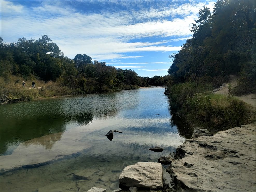
Crossing over the newer bridge, brought us into what's left of Maxdale, Texas. The area began settlements in the 1860's, it wasn't officially established with a post office until 1883. The town never really blossomed, reaching a maximum 50 residents in 1925. The post office closed in 1926 and the town slowly started declining. The population today is reported at only 4 residents.

Over at the Maxdale Cemetery is our last two geocaches, one traditional cache GC298G0 and one virtual cache GCG2EJ. From the historical marker: Established in the 1860's to serve the rural community of Pleasant Grove, this community is one of the oldest in Bell County. Land for the graveyard was given by Frank N. McBryde Sr, whose 1883 application for a post office for the community resulted in the name change to Maxdale. The earliest documented grave is that of Louisa Marlar (1849-1867), although an 1863 tombstone marks the site of a grave reinterred here from another location. Others interred here include pioneer settlers and veterans of the Civil War, World War I, World War II, and Korea.

The one headstone that caught my eye was this one belonging to: "Thorpe and Mosley, Killed in 1876 by John Carver."


That was it for today. Like I said, not a big adventure but enjoyed the wonderful day and saw some interesting places. Until next time...

Thursday, June 13, 2019

2017-10-28: A Crumbling School, Cemetery, a Bridge, Dinosaurs, and Chocolate!

Welcome back and WOW what a day! Today we have everything from a crumbling school, to a cemetery, an old bridge, going way back to the days of dinosaurs, and finishing the day with decadent CHOCOLATE! So lets get started...

After finishing up work yesterday in West Texas, we made the long drive to Killeen last night. Today was a day for geocaching and exploring. After breakfast, we made our way up to Bosque County for our first cache and a new county. The Mosheim School (GC15B39) is a crumbling landmark of an era faded into the past. The town formerly known as Live Oak was settled in the 1850s with Jonathan Dansby given as an early (if not the first) settler.


A man named Jeff Howard built the first store in 1886 and submitted the name Mosheim for a post office which was granted the following year. In 1896 Mosheim had fifty people, a school, and several businesses. The population went from 171 in 1904, to 100 by 1925 and then reached its zenith in 1941 with 200 Mosheimers. It remained close to 200 until the late 1960s when it declined to 75. The town lost its post office in 1976.


The school was built in 1923 and by 1970 it had closed it's doors. Looking at various photos of the school online, the taller section above the entry along with the roof had collapsed sometime between 2013 and 2016. There's a really good article at the KWTX website talking to two locals who grew up and went to that school.

Just up the road is the town of Clifton, where we found our next two caches at the cemetery (GC6RW7N, GCT7BK). Clifton was founded in the winter of 1852–53, when the families of Samuel Locker, Monroe Locker, Frank Kell (whose grave and statue in the photo), and T. A. McSpadden settled in the vicinity. The town was named Cliff Town after the limestone cliffs that surround it. Over the years the name was altered to Clifton. The site was originally on the banks of Clear Branch. The Masonic hall and a log schoolhouse were the first public buildings. The post office was established in 1859. The First Presbyterian Church of Clifton was organized in 1861 and is the oldest church in continuous service in the county. The Baptists built the first church building in Clifton in 1884–85. After the Civil War J. Stinnett built a flour mill that was powered by the Bosque River. It was replaced in 1868 by a limestone mill, which was eventually converted to the electric power plant that provided the first electricity for Clifton homes. A three-story school known as Rock School was built around 1870 and served the community for more than twenty years. In 1893 a new building was constructed on property donated to the Clifton school system.


In 1880 the Gulf, Colorado and Santa Fe Railway built a station a mile south of Clifton. Merchants moved their businesses closer to the railroad station, and the town thrived as a business and trade center. The Merchant Exchange and Flour Mill, the first steam flour mill in the Bosque valley, was established in 1887 or 1888. The Clifton Record, a newspaper that began publishing in 1895 under the ownership of W. C. O'Brian, continued to serve the community through the years. Clifton also served as the county seat between 1890 and 1892. Clifton Lutheran College, later known as Clifton College, opened in 1896. The community was incorporated in 1901. An earlier attempt at incorporation in 1891 failed when the election results were declared invalid. A fire on December 23, 1906, destroyed a large portion of the business district, which was eventually rebuilt. The Clifton Volunteer Fire Department was organized in 1907. The town's need for a hospital was met by Dr. V. D. Goodall and Dr. S. L. Witcher in 1938. The Lutheran Sunset Home for the elderly was established in Clifton in 1954. The town had an estimated population of 204 in 1904 and 3,195 in 1990. It had 100 businesses in the 1980s. In the early 1990s an exotic-animal preserve open to tourists was located southwest of Clifton on Farm Road 3220. In 2000 the population was 3,542 with 262 businesses.

After leaving the cemetery, we headed to the north side of town to visit a piece of history before it becomes history. The Clifton Whipple Truss Bridge (GC6RW6C) was built in 1884. Still in use as one of only two bridges crossing the North Bosque River east of town. It had asphalt over the original wooden planks. But it's days are numbered. You can kinda see in the photograph, they're building a new modern bridge right next to it. And the word is when the new one is completed that the planks will be removed making it impassable. That's a shame. I like these old bridges. They should at least leave it for pedestrians, fishing, or just because.


Around the corner from the bridge was this rock structure. Wasn't sure what it was as there were no signs or anything. Perhaps a part of the old mill? So I began to Google for answers. Not even close to being an old mill. The City of Clifton offered the State of Texas 80 acres of land along the Bosque River for a state park. The state never accepted the donation, and the area remained a city park. Civilian Conservation Corps (CCC) Company 878 arrived in June 1933 to begin work on the park. The CCC built picnic and fireplace units, a semicircular seating area, entry portals, concession building and latrine all out of limestone. The CCC left their camp in Clifton in January 1934. This is what remains of the abandoned latrine!

Then there's this building on the corner. The sign says "First Chance," but I couldn't find any information on it. Then Bryan Davis from the BackRoads of Texas FB Group was able to help me out. He sent me this information: "My late friend Anna (Wood) Compton knew a lot of local history. Not sure many will recognize this photo from 80 years ago. This was a popular stopping point just before crossing the Bosque River on the west side of Clifton, where the old Whipple Truss Bridge stood. Anna lived here with her parents in the 1930s and her dad sold bait and tackle, picnic supplies, barbeque, cigarettes, and other goods. The Wood family lived in a back room partitioned with a sheet from public view. What fascinated Anna and me was that nothing appeared being done to preserve the limestone structure which was her childhood home. I've been told it is the oldest structure in present-day Clifton, pre-dating the move of Clifton to its present location with the arrival of the railroad about 1881. I recall Dan Orbeck and Ferman Grimm saying their families also owned the structure at various times. I'm sure there are issues with it being in a flooding zone, but I hope some measures are being taken to insure this landmark, which has survived some 150 years and numerous floods, receives proper preservation."

Thank you Bryan. I never thought the building would have been that old! Here's a picture Bryan sent me from back in the past:


From there we drove north on up into Somervell County and a town called Glen Rose. The town had a couple of statues around the courthouse square.


Also in the town square, is the tiny Hopewell Post Office and our last cache for the day (GC9B44). There are (or were) Hopewells in Franklin, Houston, Red River, Smith, Upshur and Williamson Counties. Somervell’s Hopewell is now covered by Squaw Creek Lake. Fortunately, great effort was taken to preserve a part of the forgotten community by moving its tiny post office to Glen Rose to sit on the courthouse square next to the museum. It's short history lasted from 1901 through 1904.


From there we drove over to the Dinosaur Valley State Park. In 1908, a flood of epic proportions roared down the Paluxy. It washed out all bridges and culverts on the river and scoured the riverbed. A year later, nine-year-old George Adams discovered something amazing in the river:  large, three-toed tracks - theropod tracks. Nearly 20 years later, a fossil collector for the American Museum of Natural History in New York named R. T. Bird saw one of the theropod tracks in a shop in New Mexico. He decided to come to Texas and check out the site. While exploring in the river, he was amazed to discover what looked like sauropod tracks, along with the theropod tracks. The tracks were the first proof that sauropods walked on land. The park opened in 1972 to preserve these valuable dinosaur track sites and to allow people to learn from and enjoy them. They also have some nice hiking trails along the river.


Getting late in the afternoon, and both starving by this point, we stopped in the town of Hico for dinner at the Jersey Lily's Mexican Restaurant. It was pretty good. The town is also known for this legend that supposedly Billy the Kid really wasn't shot and killed in his young life. But lived out a long life under an alias here in Hico. But what we REALLY liked best about this whole town was a visit to Wiseman House Chocolates! While at the restaurant I was looking up other things and town and saw this place. We just had to go visit after dinner. And it was a good thing we did!

They had this pure hot chocolate that was the best hot chocolate we've ever tasted. Something about taking pure melted chocolate, adding a tiny bit of water to keep it from hardening, and sipping it from a shot glass. So rich and delicious that's all you really need. The best chocolate I've ever had. We ended walking out with over $100 worth of several different types of chocolate, including this pure chocolate high healed shoe for Candy! I think it'll just be displayed in our kitchen forever. I can't see eating this shoe. Does chocolate go bad? Guess we'll never know.


Well that's the end of a wonderful day! I thank you for reading and following along in our adventures! Until next time...

Sunday, December 18, 2016

2016-11-20: Hiking and Geocaching in the Fort Davis Mountains State Park

Today was a day where the weather was finally cooling down enough here in West Texas to go out and do some hiking. YAY! We decided to start with an easy trail in the Fort Davis Mountains State Park. If you have been following along with us, you'll recall we made a stop here in Fort Davis not too long ago during one of our Geocaching Adventure trips. However at that time we didn't have time to do any actual hiking, just touring the remains of the fort.

For our first hike of the season, we chose the Indian Lodge Trail. With a length of 1.37 miles and having a "challenging" rating, I would have called it more of a moderate hike. The trailhead begins behind the Indian Lodge and ascends to the views of the Davis Mountains. The trail ends connecting with the Montezuma Trail leading down to the campgrounds. Adding in the short walk back to the lodge along the road, and I'd say our total hike was just over 2 miles in length.

And of course, what's a hike without doing a little Geocaching along the way! We found a total of seven caches today, including a FTF (first to find GC6VDZP) and re-found my very first Geocache (GCHE45) which I found back in April of 2006! The log had since been replaced so I couldn't get a picture of my first signed log though.

Overall it was a great hike on a perfect weather day with some great views! We'll have to come back soon and tackle some of the other trails and caches. Thanks for stopping by to read our blog. Be sure to leave your comments and let us know you stopped by. See you next time.


Re-found my very first cache from April 2006!


Monday, March 28, 2016

2016-03-26: More Hiking and Geocaching in the Guadalupe Mountains National Park

Hello again and welcome back to another one of our Geocaching adventures. After last weeks exhausting hike up Guadalupe Peak, today was supposed to be one of those driving from cache to cache days. However, one of Candy's co-workers heard about our hike and saw the photos and she wanted to go hiking with us. She is also in the Marine Reserves and was leaving soon, so a change of plans and back to the Guadalupe Mountains National Park.

This time we decided on hiking through the McKittrick Canyon trail. That trail had an earthcache (GC1WAPB) near the trailhead and visitors center, as well as two virtual Geocaches out on the trail. When we arrived at this visitors center, a few miles east of last weeks visitor center for the peak trail, we found that the restrooms were out of order. So we drove back to the main road and the nearby rest area. While there, we found the two quick LPC Geocaches also.

Now back at the visitors center, we gathered our backpacks and headed onto the trail. It was a little bit later a start than last week as it was now close to noon. I also came prepared this time for the "day use fee" and did not have to search for loose change.

This hike was definitely easier than last week being mostly flat in the beginning. The McKittrick Canyon trail follows along the mostly dry stream bed, crossing through it several times as the trail and stream wind through the canyon. It was another clear blue sky day which made for some excellent views of the mountains on both sides of our hike. I'll let you enjoy a few pictures before I continue writing.


The next few pictures show the dry stream bed. For the first mile or so, there isn't any water flowing at all. From the looks of the erosion and the smoothness of some of the rock, it appears as though they get a whole lot of water flowing through here at times. But since we've been to West Texas, it hasn't rained that much.


After about a mile and a half down the trail we began to see a small clear stream flowing within the bed. It had a pretty decent flow rate going so it was a little puzzling. It seemed as though it may have been coming from a spring and then disappearing into the rock again. The way the trail weaved in and out, we never did see the beginning or the end of the water flow to know from where it came or where it went to. I figured on the way back, maybe we'll follow the stream bed instead of the trail to see how and where it originated.

About this time we encountered the park ranger hiking up the trail. I slowed a bit to let him catch up to me while the girls continued their pace. After a few minutes I asked him about the stream. He didn't really say it was a spring, but just that it began and ended.

He told me the story that the once land owner, Wallace Pratt (I'll get to him shortly), said the stream flowed constantly back in the 1920's and 30's through the canyon until it exited into the desert and dried up. Then in the late 30's and early 40's there were two floods. Mr. Pratt said that after the second flood, the stream just sank into the ground. And from then on it just flows on a few segments for a short distance.

So I still don't know how it originates or where it ends. But we will have to return again for another hike. Maybe we'll follow the stream bed then to find out.


So now for the next half mile or so, we're still hiking along with the park ranger and I notice on my GPS that we're getting closer to our first virtual Geocache (GC3A26). At about 300' away from the cache pointing to the right, the park ranger also says he has arrived at his destination. It seems we were going to the same place. Although he didn't know anything about Geocaching because I was explaining it to him along the way and that it was the main reason that had us hiking this trail.

We left the trail at these two stone pillars which led up to this old stone. The Wallace Pratt Lodge was the summer residence of Wallace Pratt (1885-1981), the principal donor of the lands that would become Guadalupe Mountains National Park. Pratt was a petroleum geologist employed by the Humble Oil Company, scouting for oilfield leases in west Texas. Pratt visited the Guadalupe Mountains in 1921, and taking a liking to the place, he bought a quarter share of the McCombs Ranch. There was at one time a road that led down into the canyon to the house. But the park service had it torn up and removed long ago.

In 1929 Pratt bought out his partners, ending up owning a large portion of the canyon, which featured waterfalls flowing over travertine dams, a lush, quiet place in the high desert. In the winter of 1931-1932 Pratt started construction of a house in the canyon, designed by Houston architect Joseph Staub. The cabin was built by Staub's former employee Vance Phenix and Vance's brother Dean, a carpenter, with stonemason Adolph May. The cabin was built of local limestone and heart pine. There was even a separate two car garage for their "his and hers" Mecedes-Benz's.The Pratt family spent summers at the cabin, which they called the Stone Cabin, and briefly lived at the cabin during Wallace Pratt's early retirement, while they built their final retirement home, the Ship On The Desert, outside of the canyon. The cabin accommodated the Ship on the Desert's architect during its construction. After the family moved to Tucson, Arizona, they donated the cabin, new house and surrounding lands of more than 5,000 acres (2,000 ha) to the National Park Service, the nucleus of Guadalupe Mountains National Park. The cabin was listed on the National Register of Historic Places on March 26, 1975.


So after touring through the old house, we thanked him and continued further up the trail. Now here's where it gets really interesting...


About another mile down the trail we catch up to another couple who left the Pratt House just before us. They were at a fork in the trail. There was a sign there pointing to the "Grotto" to the left and continuing the McKittrick Trail to the right. They asked us if we had been on the trail before, but this was the first time for us all. They were looking for the trail that took them to higher elevation to view the canyon. We wanted the correct trail that led to the virtual cache! They remembered something the park ranger had told them about the Grotto, but didn't remember if that meant to follow that trail. Our GPS was leaning 3.4 miles slightly right. But that doesn't mean much winding around through the mountains. So they went left and we went right.

About a 100' further and we began climbing. Now up to this point and for the last 3 miles to the visitors center, we ONLY had a 200' elevation increase! Now we were starting to climb. I think this was the way the other couple needed to go also.

Even though the elevation was increasing more dramatically, it was still a fairly easy trail for a moderate rating. Then we encounter the rocks!!! The trail went from a smooth incline to an extremely rocky, big boulder steep incline! This was more like rock climbing than a hiking trail. Even the severe rated trail for the peak wasn't this rough. But we're adventurers, so we continue on. Perhaps it's just a short rough section that gets back to normal just around the next boulder. And according to the GPS, we're still heading in the right direction.

Continuing to climb, up another 100', then another 100', just when you think that if you climb over this spot and around that corner, there we'd find the normal trail again. Somewhere around the 400'-500' mark, it looked like a split so I quickly went ahead to the left to see if there was a way through. Nope that was a dead end. So I yelled back to have them head the other way.
I went ahead quickly up that side as well and saw no end in sight. It was just more large rocks and steep climbing. Finally I suggested we call it quits and head back down. It looked like we were getting closer to the top, but I'd hate to have climbed another 200'-300' only to encounter and dead end cliff wall.

So we all agreed and headed back down the rocks. Finally we get back down to the normal looking trail when suddenly there's a fork in the trail. WHAT? We don't remember that! Where did THAT come from? I zoom in on the GPS and noticed that we had came from the left. NO WAY!!! The TRAIL actually switched back to continue up the other direction! We didn't even notice that. So in reality, we were NOT climbing up the trail but just a rock wash.


The two pictures above don't do justice, but kinda give you a sample of what we climbed. We didn't take many pictures in that area as we kept our phones in our pockets to keep our hands free for climbing! In the photo below, you see the thick trees at the bottom? Down in there is where we missed the switchback on the trail. Now from there follow the crevice up the left to that large shaded area. That's about where we climbed to before turning back down.


So while we were at the switchback, three hikers came through and we asked if they had been on this trail before. Nope, it was their first time as well on this trail but said they hiked a lot. It showed as they walked fairly quickly. After debating a brief moment, we decided to continue forward on the correct trail to see where if we could make it to the other virtual Geocache, still more than three miles away. But that was a straight line distance, not the actual trail distance.

We caught up with the three hikers after a couple of switchbacks as they were seated and grabbing a snack. One of them began asking us what our plan was and if we had a car parked at the visitors center. He informed us that the front gate would be locked at 6:00 pm and we should be back at the visitors center by 5:30 in order to make the drive out the gate in time. By now it was 2:30 and there was no way to make it to the virtual cache AND still have time to make it back. So we decided to turn around and head back.

Just about that time, the couple we met by the Pratt House and later at the fork to the Grotto came walking down the trail from further up. They were puzzled at how they had passed us when I explained about our misfortune of making the wrong turn and we hiked up the rocks. They said the Grotto wasn't that far down their trail which they took. After looking at it, they doubled back and followed the trail we took. They however made the switchback and passed us while we were rock climbing.


The walk back was brisk, yet seemed to take forever. Especially that last mile! I kept watch on the GPS and it wouldn't move for long stretches as we rounded the base of a mountain along the trail. It just kept pointing to the mountain as we had to round the base to the other side. Then the compass would point straight and we'd start closing in on the car. But the needle would start to veer off to the side again as we rounded another corner. Our total hiking distance according to the GPS was 9.19 miles.

It was another great Geocaching adventure and a fun hike. Not as sore this time as last week. Even with our wrong turn climbing up the rocks, we still had a good day. Candy's co-worker also enjoyed her day hiking and learning about Geocaching. It's too bad she's being transferred in a couple weeks. Maybe we'll be able to get one more hike in before that.

That's it for now. See you back again next time.