Showing posts with label hotel. Show all posts

Sunday, May 15, 2016

2016-04-03: A Presidential Geocaching Adventure, History and More Cemeteries

Today's Geocaching Adventure took us on a Presidential drive to a historical home. After a busy 6-day work week, it was good to get out and do some exploring. We decided to relax this time out instead of our recent hikes. Taking time for a good home cooked breakfast, we headed east on I-20 into Midland, Texas. Our first stop was a Starbucks since we haven't had one in a long while!
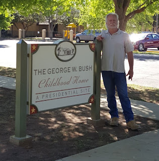
President George W. Bush childhood home.Our first Geocache was a Presidential Virtual! (GC89D4) The home of TWO Presidents! From the historical sign out front:

"George Herbert Walker Bush and wife Barbara came to Texas in 1948, moving to Midland with their young son George Walker Bush in 1950. They bought this house in 1951 and while here faced the loss of their daughter Robin and celebrated the birth of two sons. The years spent here were vital for young George, who attended Sam Houston Elementary, made lifelong friends and played baseball. The family moved to a larger home in 1955 and then later moved to Houston.

This c. 1939 traditional style house reflects transition from Tudor to Ranch detailing. Unique in history, it was home to two Presidents: George H. W. and George W. Bush; two Governors: George W. Bush (TX) and Jeb Bush (FL); and First Lady Barbara Bush."

However, while we were there it hadn't opened yet for the day. It was Sunday around 11:00 AM and we weren't up for waiting a couple of hours for an inside tour. Maybe next time we're in the area.

George W. Bush childhood home

Leaving the downtown presidential home, we continued east several miles outside the city of Midland to another of Texas' historical marker caches. This one was located near Midland County's first producing oil well (GC2A3Q4). There wasn't much to actually SEE at this spot, but here's what the historical marker reads:
The discovery of oil in the Permian Basin during the 1920's helped sustain the area economy during The Great Depression, and many oil and gas companies established headquarters in Midland. Not until the 1940's, though, did Midland County begin seeing its own productive wells. Geologist H. L. Beckman worked with the Rowan Drilling Company to stake out Humble Oil and Refining Company's No.1 Mrs. O.P. Buchanan oil well at this site. They spudded the well on September 14, 1944 and completed it on November 6, 1945 at a total depth of 12,574 feet. The well produced 332 barrels of oil in 29 hours and became Midland County's first producing oil well. It was plugged on August 1, 1947.
On the way to our next cache, we arrived in Garden City and the Glasscock County Courthouse and Jail. On May 9, 1893, a little over one month from the date of Glasscock County's formal organization, the first county commissioner's court issued bonds to erect a combination courthouse / jail buildings. The small 2-story structure was completed on February 12, 1894. Originally, the ground floor was used for court session and the 2nd story for the jail. On August 27, 1910, a larger building was completed and has been in continual use since 1910. The smaller building was then used entirely as the jail until a new one replaced it in 1980.

A few blocks away was the Garden City Cemetery and our next Geocache (GC30CB1). We couldn't get the cache located in the cemetery as there was a gardener mowing right near the cache location. The one we did find was located outside the cemetery near the entrance.

The next cache on the agenda was for another Texas ghost town (GC14VV1). Not much to see here except for the historical marker:
The pioneer settlement of Cummins developed at this site about 1890 around the saddle and harness shop of the earliest permanent settler, Mississippi native Robert Benjamin Cummins (b. 1848). A post office the following year the nearby town of Sterling City (1.9 miles east) was founded. The two towns became rivals for the designation of county seat when the Texas Legislature created Sterling County from Tom Green County on March 4, 1891. An intense publicity campaign developed, aided by the writings of the respective town newspaper editors: W. L. Thurman of the Cummins paper, the "North Concho News", and S. R. Ezzell of the "Sterling Courier". An election, conducted May 20, 1891, appeared to be a victory for Cummins until several voting boxes were dismissed for technical reasons, resulting in a tie. A second election on July 7 gave Sterling City a 13-vote margin and it was named the county seat. Most Cummins businesses and residents had moved to Sterling City by the end of 1891. Nothing remains of the early townsite, which once included a school, saloon, meat market, mercantile, blacksmith shop, and grocery stores.
Now that you know the story of the rivalry between Cummins and Sterling City, let's drive over to see what all the fuss was about. Arriving at the newer Sterling County Court House, you can still see the original 1912 County Jail building to the right of it. Like most of the old west jails we've seen, the lower level included living quarters for the sheriff and this one had seven jail cells on the upper floor.

Sterling County Courthouse and Jail

Across the street from the courthouse was this restored 1910 Hotel. Although I think the upper floors are still used as guest rooms or apartments, the lower floor appears to be an antique store.

Old Sterling City Hotel


A few blocks away was an old train depot. There wasn't a cache placed there, but I noticed the historical sign pointing the way to it and had to check it out. Attracted by the area's livestock production, nearby shipping points, and the financial support of the town, the Concho, San Saba & Llano Valley Railroad began building a line to Sterling City in 1909. A boxcar served as the depot until this mission revival building was completed. Highway and pipeline construction caused a decline in rail traffic and the line closed in 1958. Only this restored depot remains as a reminder of the early rail service that helped develop the area, and is now used as a community center.

Old Sterling City Train Depot

Our last cache here was at the Sterling City Cemetery (GC47QPH). Still in use today and well maintained. But a few miles down the road was another of the Texas ghost towns and the only thing that remains is the Montvale Cemetery (GC14PMK).
The community of Montvale was established in 1884 when the pioneer settlement of St. Elmo was relocated here. Then a part of Tom Green County, Montvale was located on the Shafter Military Trail, an early road from Fort Concho. A community school, the earliest in the area, was in operation by 1886. Three years later the town was platted by H. B. Tarver, the surveyor for Tom Green County. It is believed the settlement was named for a nearby hill referred to in Tarver's field notes as Mt. Vale. Early businesses in Montvale included the saddle and harness shop of R. B. Cummins and the general store and blacksmith shop of B. Z. Cooper. The town was also the site of a Methodist church, a hotel, a post office and a variety of stores. About 1889 R. B. Cummins started the town of Cummins (5.4 miles northwest) upriver from Montvale. Both settlements began to decline in 1891 with the establishment of Sterling City (3.5 miles northwest) as the seat of government for the newly created Sterling County. A community cemetery is all that remains of the townsite of Montvale, a pioneer settlement that played an important role in the area's development.


Just south of the cemetery was our next cache at the Sherwood Lane Bridge (GC14VW4). It hadn't been found in two years and sad to say we hadn't find it either. It is an old single lane bridge still used when the small river flows too deep over the gravel road. And from the looks of the debris under and around the bridge, the water appears to have risen 3-4 feet above its current height! Probably why we couldn't find the Geocache. Maybe swept down river some where...

Sherwood Lane Bridge


Continuing down US87 south, we happened upon a roadside attraction and our next Geocache (GC1QBG9). I'm not sure who Minnie Brown is, but she must have a following here in this part of West Texas. There were many displays here to look at along the side of the road at this house, but I only posted a few. You'll have to go and check out the rest of them. It's FREE and all you'll need to do is pull safely off the highway onto the wide shoulder area.


Our final stop brought us to the historical marker for another Texas ghost town (GC14VTW). There wasn't much anything here to see and so I didn't take any photos. The town of Broome, on the North Concho River and U.S. Highway 87 ten miles southeast of Sterling City in east central Sterling County, was founded in 1924 as a station on the Panhandle and Santa Fe Railway and was named for early rancher C. A. Broome. The community acquired a post office that was discontinued in 1939. In 1947 the settlement had a combination store and filling station and a population of twenty-five. Its population was eighteen in 1980, and by 1990 no population figures were reported for the community.

That was it for today. Sorry for the delay in writing this blog post. With me working 60+ hours a week now it has cut into our Geocaching time on the weekends. But stay in touch and check back soon. We hope to be able to get back to our weekend Geocaching Adventures shortly.

Monday, March 21, 2016

2016-03-19: Geocaching History in Pecos Texas and a Couple of Cemeteries

With the move last weekend from Lubbock down to Monahans, Texas, we didn't get a chance to go Geocaching and exploring. So today was a good day to get out and explore some new areas and pick up some new counties. Candy had to work a few hours this morning so we got a late start.

We headed west on I-20 towards Pecos and by now it was getting close to lunch time and neither one of us have eaten anything all morning. So a quick Google of restaurants in Pecos and I decided on Old Mill BBQ and Burritos. I ordered the BBQ brisket and sausage, while Candy ordered a cheese burger and fries. And we still got the traditional nachos and salsa while waiting for our food. All the food there was pretty good, so it'll definitely be getting a return visit from us.

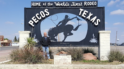
Pecos Texas Home of the World's First RodeoNow that we have full bellies, it's time to go exploring and Geocaching! Out first stop was at the rodeo. The first cache (GC234FP) was to highlight that the town of Pecos hosted the worlds very first rodeo. Held a block south of the Pecos courthouse on July 4, 1883. The rodeo started with claims of three cattle ranches having the fastest steer ropers; the NA, the W, and the Lazy Y ranches.

Settlers in town for the Fourth of July picnic were spectators. The prizes were blue ribbons cut by pocket knife from a new dress of a 4-year old girl in the crowd.

The best roper was Morg Livingston of the NA Ranch and second place was Trav Windham of the Lazy Y.

A photo of the Judge Roy Bean Courthouse replica.Just down the road was the West of the Pecos Museum and our next Geocache (GC47RDM). On the outside was a replica office and courthouse of Judge Roy Bean, Justice of the Peace and the Law. Phantly Roy Bean, Jr. (c. 1825 – March 16, 1903) was an eccentric U.S. saloon-keeper and Justice of the Peace in Val Verde County, Texas, who called himself "The Law West of the Pecos". According to legend, Judge Roy Bean held court in his saloon along the Rio Grande on a desolate stretch of the Chihuahuan Desert of southwest Texas. After his death, Western films and books cast him as a hanging judge, although he is known to have sentenced only two men to hang, one of whom escaped.

The headstone for Pecos Texas gunslinger Robert Clay Allison.Next to the office was the gravesite of Clay Allison. Robert Clay Allison (September 2, 1841 – July 3, 1887) was a cattle rancher, cattle broker, and sometimes gunfighter of the American Old West. He fought for the Confederacy in the Civil War. Allison had a reputation for violence, having survived several one-on-one knife and gunfights (some with lawmen), as well as being implicated in a number of vigilante jail break-ins and lynchings. He is posthumously known as the man who "...never killed a man that did not need killing." A drunken Allison once rode his horse through town nearly naked—wearing only his gunbelt.

Also on the grounds was an old jail replica and the Mesquite House, the oldest house in Pecos.

Photo of the West of the Texas Museum hotel and saloon.

Then came the museum itself. On the right was the original saloon and hotel on the left. Touted as the “best hotel between Fort Worth and El Paso”, The Number 11 Saloon, with guestrooms on the second floor – was built in 1896 of Pecos Valley red sandstone. The quarry was just 8 miles east of Pecos. The three story hotel was added in 1904 by R.S. Johnson. Mr. Johnson, a retired Texas Ranger, was in charge of the saloon and his wife ran the hotel. The hotel served as a headquarters for land promoters, salesmen and families of settlers in the early years of Pecos Valley development. The hotel and saloon were restored in 1962 and opened as the West of the Pecos Museum in 1963. Many civic organizations and groups contributed volunteer hours and resources to the museum’s exhibits. Original pressed tin ceiling, hand – carved newel posts were preserved.. Most of the furnishings in the Number 11 Saloon are original. Over 50 rooms of pioneer history and memorabilia are housed in the old hotel and saloon.
A bartender at the Pecos Texas Saloon.

Photo of a bullet hole located at the Pecos Saloon.

An old jail house located in Pecos Texas.

Photo of the Mesquite House, the oldest house in Pecos Texas.

A few blocks away was the Old Pecos Cemetery (GC1P62N). The original burial site of the gunslinger Clay Allison before being relocated outside the museum. The Old Pecos Cemetery was used from 1880 to 1910 by settlers in the Pecos Valley. Originally established for railroad construction workers who died during the building of the railroad. There are only 6 marked graves remaining and some wooden crosses for the unknown.

A photo of the Old Pecos Cemetery entrance.Three wooden crosses for unknown graves at the Old Pecos Museum.

Leaving Pecos, we headed north on US-285 to Hwy 302 into the small town of Mentone. A quick rest area cache (GC2H0BC) on the west end of town before getting a virtual cache (GC621F) at the Loving County Courthouse. Though I don't understand the name that well considering that "Loving" County is the LEAST populated county in the lower 48 states! In September 2000, National Geographic Magazine did a series of articles on various Zip Codes in the United States. Here is a link to their website for this location: Zip Code 79754.

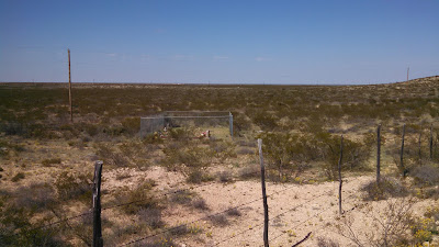
Photo of the headstone for Shady Davis who died in 1912.Our next cache and always a favorite was one placed at a cemetery (GC638RA). Since Loving County is sparsely populated, there aren't any "official" cemeteries. Burials are typically on the family ranch. This Geocache was the only cemetery cache located within the county and had only 3 grave sites. The first was dated 1912 for Shady Davis. Shady Davis was a young cowboy who was fatally injured by being dragged by his horse during a roundup. The two other graves were from 1992 and 2007.
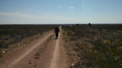
Located on the Slash (Johnson Brothers) Ranch but accessible via a few oil field access roads, it was some rough driving for the GeoPrius. We both agreed (again) that it was time for a Jeep! One of these days... Anyway, we got to within .15 miles from the cemetery when we encountered a rut I thought to be too deep for the car. So we hiked it the remaining way.

A photo of the three graves located on the Slash Ranch in Texas.

A photo of the walk back to the GeoPrius.

After another lonely cache in the middle of nowhere (GC2MX4H), we continued north on US285 almost to the New Mexico state line. There was the location of our next historic Geocache (GC36AG6) along the old section of the Pecos River Railroad. First opening in 1891, it later merged with the Panhandle and Sante Fe Railroad in 1948. Eventually this original section was abandoned in 1990-91.

The old railroad tracks for the abandoned Pecos River Railway.

That was pretty much it for the day. Not a whole lot, but we did have a good adventure and especially enjoyed touring the museum and learning about the history of the area. Tomorrow we have a big hike planned, so we hope you return for that. See you soon.

Thursday, March 3, 2016

2016-02-28: Geocaching Through History and Counties in North Texas

Hello again and welcome back to our Geocaching adventure blog. We hope you have been enjoying our travels so far. Today we set out to find caches in some new Texas counties. We're past the halfway point finishing the day with 133 of the 254 Texas counties.

Setting out from Lubbock after breakfast, we headed north on I-27. Our first stop was the Abernathy Cemetery in Hale County. A quick cache find here. The cache was located in some trees behind this headstone. Of all the cemeteries we've been in and the headstones looked at, I think this was the first with a Corvette on top. I'm sure this one cost a pretty penny too. However, after spending so much on this headstone, you would have thought they would have spelled "BELEIVE" correctly!


Continuing north on I-27 and a few more quick caches near an old grain silo, another at the Hale Center Cemetery, and follow by the Kress Cemetery.


Then, a couple miles to the northeast of the town of Kress and sitting out in the middle of farm land lies three very lonely graves. The Wright Cemetery cache page (GC5R9B1) doesn't give much history, but I was able to locate some info at Find A Grave showing 11 burials here. I only found 3 headstones. Looks like headstones have been run over by farm tractors throughout the years.


About a mile down the road from the cemetery looking across the farms and the flat plains, I saw a tiny black silhouette of an old truck and just had to investigate. And this is what we found sitting out on the corner of the dirt road and the end of the driveway to the farm house. It had seen better days and would make a great restoration project.


The next cache on our journey today was at Rose Hill Cemetery (GC31F7A). The history of this community cemetery dates back to October 1890. Just three months after Swisher County was organized and Tulia was named county seat. The first recorded burial here is that of 18 year old Louis Harral who died on October 17, 1890. His parents obtained permission from landowner T. W. Adams to bury their son on this hillside south of the Middle Tule Creek. Twelve days later, 4 year old Robert Alonzo Hutchinson died and was buried on the hill near Louis. In 1906 five acres of land surrounding the graves were officially set aside for a community cemetery.


Also in Tulia on display at the local VFW is our next cache (GC14K6N). This retired North American F-86 SabreJet.


Our next stop located in Briscoe County was built in 1894 of handcut stone hauled here by horse-drawn wagons from Tule Canyon. The Briscoe County Jail (GC2KVTG) stands as the lasting reminder of what courage and dedication mean in preserving law, order and integrity.

Early day sheriff's families rented the lower floor as a residence. It was also used by Red Cross workers for sewing during World War I. Near the old jail is the county courthouse and administration building.


Continuing east from Tulia over to the town of Silverton for our next cemetery cache (GC5N53J). I couldn't find much history about Silverton Cemetery, but while finding the cache I spotted these to headstones belonging to Robert S. Christian (23) and Warner S. Reid (24). They both died on the same day of October 23, 1895. After doing further research, I found newspaper article from from 1995 that had the story of these two. In summary, while moving a very large herd of cattle along with 75 other cowboys; lightning struck killing these two young men, both their horses, and ten cattle. You can see the full story from the newspaper link.


A couple more caches later and we're in the little town of Quitaque and our next  two caches (GC1RVHP). The first settler in the area was the Comanchero trader José Piedad Tafoya, who operated a trading post on the site from 1865 to 1867, trading dry goods and ammunition to the Comanches for rustled livestock. In 1877 George Baker drove a herd of about 2,000 cattle to the Quitaque area, where he headquartered the Lazy F Ranch. Charles Goodnight bought the Lazy F in 1880 and introduced the name Quitaque, which he believed was the Indian word for "end of the trail."

Residents used other area graveyards to bury the deceased until 1922 when brothers Alvin and Edgar Howard donated ten acres for cemetery use. The first person interred in RestHaven Cemetery (GC1QZJV) was Katie Daniel in 1922.

The next town down the road was originally called Turkey Creek, then Turkey Roost by the locals. Eventually it was shortened to just Turkey by the time the Turkey Hotel, now a Bed & Breakfast, opened its doors in 1927. There was supposed to be a cache hidden near the hotel (GC1X8B3), but  we couldn't find it and neither could the last few cachers. It looked as though there may have been some bushes there at one time. And the cache owner hasn't been active since 2010.


Turkey is also known for being the hometown of Bob Wills which is our next virtual cache (GCCDBD). James Robert "Bob" Wills (1905 – 1975) was an American Western swing musician, songwriter, and bandleader. Considered by music authorities as the co-founder of Western swing, he was universally known as the King of Western Swing. Wills formed several bands and played radio stations around the South and West until he formed the Texas Playboys in 1934 with Wills on fiddle, Tommy Duncan on piano and vocals, rhythm guitarist June Whalin, tenor banjoist Johnnie Lee Wills, and Kermit Whalin, who played steel guitar and bass. The band played regularly on a Tulsa, Oklahoma radio station and added Leon McAuliffe on steel guitar, pianist Al Stricklin, drummer Smokey Dacus, and a horn section that expanded the band's sound. Wills favored jazz-like arrangements and the band found national popularity into the 1940s with such hits as "Steel Guitar Rag", "New San Antonio Rose", "Smoke On The Water", "Stars And Stripes On Iwo Jima", and "New Spanish Two Step".

Also in town is this old restored gas station and Bob Wills and the Playboys tour bus.


Moving on to our next county and next cache (GC62PGC). This area of Motley County was first called "White Flat" due to the tall white needlegrass which covered the flat prairie land. A post office, named Whiteflat, was established for the rural settlement in 1890 at the request of W. R. Tilson.

At its height, the community boasted four grocery stores, three service stations, three garages, two cafes, a hardware store, two gins, and three churches. A school first housed in a one room schoolhouse built by volunteers, opened in 1890. It was replaced by a four room school in 1908, and in 1922 a new two story brick structure was erected (see photo). It also served as a community gathering place.

Dependent on an economy based on agriculture and small family farms, the community began to decline during the depression and dust bowl years of the 1930's. The Whiteflat school closed in 1946 when it was consolidated with Matador schools. The local churches disbanded in the 1960's, the post office closed in 1966 following the death of the last postmaster, and the last remaining retail store closed in 1968. A few residence still exist, but it's pretty much a ghost town.

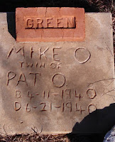
The Whiteflat Cemetery (GC2P34E) dates back to 1894. The hardest thing to see although quite common at that time, are headstones for babies and children. And here the Green family had three. And based on the headstones, they were probably of little means as well.


Our next cache in Motley County was Bob's Oil Well (GC17NTQ) and a piece of American roadside attractions. From the historical marker: "Greenville, Texas native Luther Bedford "Bob" Robertson (1894-1947), a veteran of WWI, came to Matador in the 1920's. He was a gas station attendant in 1932 when he decided to open a service station here. To promote his new business, he built a wooden oil derrick over the station. He patented his design, and in 1939 replaced the wooden derrick with one of steel that reached 84 feet in height and included lights.
Robertson was a gifted businessman and promoter, and he used any opportunity to advertise his operation and attract customers. He kept a cage of live rattlesnakes for the amusement of tourists, and from that initial attraction grew a zoo that included lions, monkeys, coyotes, a white buffalo and other animals. He paid long distance truckers to place advertising signs at strategic points across the nation noting the mileage to Bob's Oil Well in Matador, and they became well known to the motoring public. As a result of his success, Robertson enlarged his operation to include a grocery, cafe and garage.
Bob Robertson dies in 1947, and two weeks later a high wind toppled the steel derrick that had been the trademark of his business. His widow restored it two years later with even larger lights. The business did not continue long after, however, and closed in the 1950's. Later efforts to re-open it were short lived. Today, the site serves as a reminder of a time when such bold roadside architecture was in its infancy and of a man who, through his business, widely promoted his adopted hometown."


The Motley County Jail was next. Similar to the Briscoe County Jail above, this 2-story jail was erected in 1891, the year Motley County was organized. Cells were on the top floor of the structure and the jailer's living quarters on the lower level. The first courthouse, also built in 1891, later burned, but this jail remains as a symbol of Motley County's frontier heritage.


Our last cache to highlight was at the Cottle County Heritage Museum (GC13AA8). I liked the old ambulance and fire truck outside. 


It was a long day and I think we drove over 300 miles. But we learned a lot of history, saw some cool sites, and just had a great day driving through Texas.