Showing posts with label railroad. Show all posts

Friday, November 25, 2022

2021-03-26: Day 4 of Turning a 1400 Mile Road Trip into a 3404 Mile Adventure! From Ohio into Indiana.

So today was Day 4 of our adventurous road trip where we turned a simple 1400 mile drive from NC to TX into a 12 day 3404 mile sightseeing tour! On this fourth day we finished traveling through Ohio and into Indiana, continuing to pick up new geocaching counties and finding more remnants of the old National Road. So come ride along with us as I share our geocaching adventures with you.


Waking up in Columbus, Ohio this morning, our first stop was for some Starbucks coffee. Well, Candy got a Starbucks coffee. I got the geocache in the parking lot (GC25QYX). Then we drove a few blocks away to a Dunkin Donuts where I then got a coffee and donuts for myself as well as a muffin for Candy.

Continuing our westbound roadtrip and following the Historic National Road (now US-40), we pulled into the Sunset Cemetery in Franklin County for several geocaches hidden here (GC77D86, GC4QFG8, GC54E7E, GC4ER7X). All three geocaches had a lot of favorite points awarded to them so we just had to stop by and find them. A nice Veterans Memorial was on display. But Jack's Cache was by far the favorite and even posted both a photo and video of it below. Be sure to have your sound turned up when playing the video!


(Turn Sound ON With Video!)

One of the advantages of driving the backroads on a roadtrip are the unexpected gems that get to be discovered along the way! Passing through the small Village of Lafayette in Madison County, Ohio, what first got me to stop was spotting this tour of Jeep history somebody had displayed on this fence. It was a perfect photo opp for the Geo Jeep Travel Bug!


Then taking a closer look at the old buildings along this stretch of the historical highway. This first one here I can't find much information on it. The plaque above the front entrance says "Deer Creek Tp, Sub-Dist No 1, 1906." I'm thinking it was an early school that has long been closed. One of the rear buildings has B. S. A. on it and can only assume that at some time in its historical past that the Boy Scouts of America had rented the building. If any of you can provide further details, please use the comment box below. It would be greatly appreciated.


This other building across the street is on the National Register of Historical Places. From the historical marker: "The Red Brick Tavern is a classic roadside inn and tavern from the heyday of the National Road. Constructed between 1836 and 1837, it was in operation when the road was completed past its front door. Over the years, the Red Brick Tavern was a popular place for travelers along the Historic National Road in Ohio. The Tavern hosted six presidents of the United States; John Quincy Adams, Martin Van Buren, William Henry Harrison, John Tyler, Zachery Taylor, and Warren G. Harding."


Running north and south along the west side of Lafayette is Deer Creek. To claim a geocache in Madison County we went to the Deer Creek Cemetery (GC1ZDYX) which is next to the creek. While some of my favorite geocaches are cemetery caches, I was more interested in the geocache next to the cemetery.

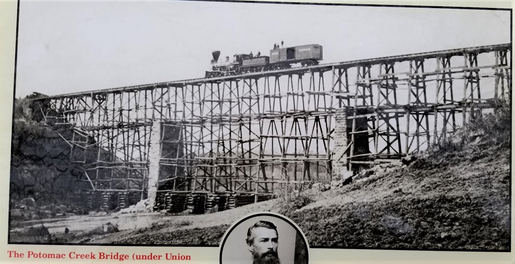
Crossing the creek about a 1000 feet south of the current alignment of the National Road / US-40, spans the remnants of an early railroad bridge This Interurban bridge was part of the railway that was part of the Springfield London Columbus route. This railway was run by the Columbus London & Springfield Railway from 1902-1939. The Interurbans provided a quick and cheap alternative to regular railroad for transporting people. As for the geocache, well I couldn't find it. Along with many others. It has since been archived.


The next county over is Clark County. It's also where my next two geocaches are located (GCZEFX, GCRDQC). In 1841, Ezra Baker gave the township land to the northeast edge of Enon for a cemetery. Land was added to the Enon Cemetery in 1884, in 1906, and again in 1978. There are earlier burials than 1841, but these were moved from family plots. Three Revolutionary soldiers, two War of 1812 soldiers, many from the Civil War, plus soldiers of more recent wars, are buried in the cemetery. There is a Soldier’s Monument, bearing the names of 31 local men who died during the Civil War, but not necessarily brought home for burial.


Continuing westbound a few miles and dropping down into Greene County, we make a stop for a quick geocache in the corner of a parking lot to claim the county (GC104NY).

After Greene was Montgomery County and the next three geocaches. The first one was located at the Polk Grove Cemetery (GC3W2YG). The cemetery is located next to the Polk Grove United Church of Christ. Since I didn't have time to look around the cemetery, I'll just leave you with this little tidbit. What's the difference between a cemetery and a graveyard? A graveyard is what they used to call a cemetery located on church grounds.

The second geocache was another location along the historic National Road. Patty's Bridge (GC196PD), located in Englewood Metro Park, is named after the James Patty family who owned a 160-acre farm in Butler Township. The Patty's brick farmhouse, torn down in about 1975, was located on the high ground northeast of the bridge. The original stone abutments for the bridge are still in place and demonstrate the skill of the workman building the highway. The National Road was America's first interstate highway.


Thomas Jefferson was president when construction of the road began in 1807. It started in Cumberland, MD and reached this part of Ohio in about 1838. The original route of the National Road took it due west of Patty's Bridge and into Harrisburg (now Englewood) Ohio. After Englewood Dam was completed in 1922, the National Road (which later became U. S. Route 40) was rerouted to the south and over the dam. By 1840, the National Road was completed to Vandalia, IL and then later to St. Louis, MO. Today this road spans the entire United States from Cumberland, MD to San Francisco, CA.


We stopped for one more geocache in Montgomery County. It was for a tasty treat at the Esther Price Candies chocolate factory (GC44BKB). It was an expensive geocache. Yep, we bought about $60 worth of chocolates by the time we left!


Our final county geocache for Ohio was a quick roadside stop in Preble County (GC2PMGT).

Crossing over into Indiana, the first county is Wayne County. And for our next geocache we stopped at the Old National Road Welcome Center (GC1WJPK). The Indiana portion was built between 1829 and 1834, linking the eastern seashore with the western interior. The automobile revived The National Road in the 1920's. As cars and trucks took to the road, the federal government established a nationwide network of paved, all-weather highways.

The Old National Road was one of the first routes designated under the new federal highway numbering system in 1926, US Route 40, a transcontinental highway. Once again, the new road gave way to new opportunities. Like the blacksmith shops and taverns of the past, gas station, diners, and motels lead the way to a new era of prosperity. Until the 1970's, with the completion of Interstate 70, US-40 was one of the country's primary east-west routes.

Next door over in Henry County, my geocaching county stop was at the New Lisbon Cemetery (GC8RFP1). After finding the geocache, just a quick glance around and a photo before continuing down the road.


Wanting to make up time and get to Indianapolis before it gets too late, I hop onto Interstate 70. The next county is Hancock County. We stopped for a quick westbound rest area geocache (GCPTZV).

We finally pulled into Indianapolis and I head to the Indianapolis Speedway. But it was too late. The Speedway was closing. From there we drove to the south side of the city to the Holy Cross and St Joseph Cemetery. I was here once before way back in 2007. I was once an over-the-road truck driver. The trucking company I worked for had a terminal several blocks away. While I was there getting the truck serviced, I saw online that there were some famous interments in this cemetery and walked down to see them.


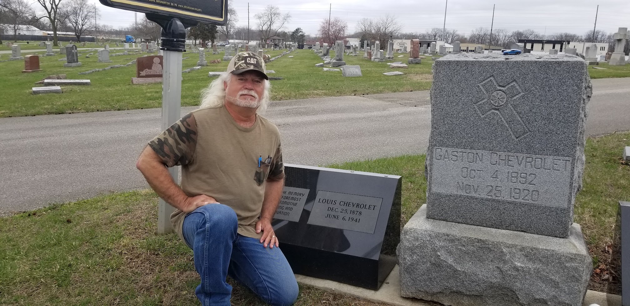
Now they have some much needed upgraded headstones to replace the neglected and broken previous headstones. And a new historical marker which reads: "There are few better known names in automotive circles world wide than Chevrolet. Millions drive the Internationally respected cars, but few know that the company and its revered name originated with three brothers, Louis, Gaston and Arthur Chevrolet. Of Swiss heritage, their story is one that reflects the very foundation of American society. Louis migrated to America at the turn of the 20th century, and after earning enough money, sent for his brothers.

"The brothers immersed themselves in automotive technology as designers, mechanics, and racing drivers. All three raced multiple times in the famed Indianapolis 500, with Gaston winning the 1920 classic. Capitalizing on their huge popularity, Louis founded the Chevrolet Motor Company in 1911. And, despite leaving the firm in 1916, the automotive giant retains the name."


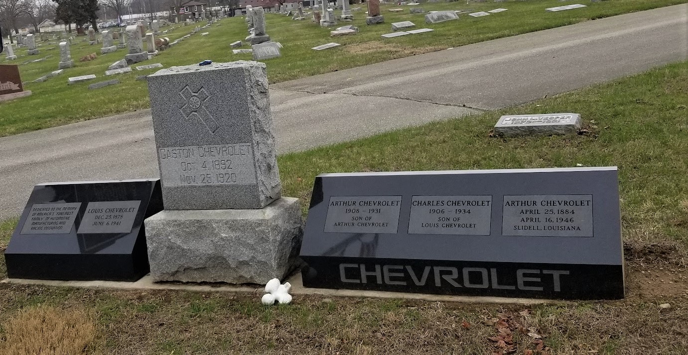
After Gaston won the 1920 Indianapolis 500, he died later that year in a racing accident. Louis died of a heart attack in 1941. Arthur retired in 1942 to Slidell, Louisiana where after suffering from depression, he committed suicide in 1946.

To get credit for Marion County, we went to Concordia Cemetery just a block away. There we found two geocaches to complete the spot on the map (GC2B3N9, GC2B45F).

That was it for Day #4. We drove up to Crawfordsville in Montgomery County. That's the next county we need and the next location of our geocaches. So we found a place to stay there for the night. Tomorrow we'll finish up Indiana and start into Illinois. I look forward to seeing you back again.

To follow along on our travels and keep up with my latest blogs, you may do so here of course by clicking the "Follow" button to the right. But also by using one or more of your favorite of these social media platforms: FacebookMeWeGabRedditParlorTwitterRVillageGETTRInstagram, and TruthSocial. These all link directly to my profiles. Again, please feel free to comment and / or share.

Saturday, October 8, 2022

2021-03-24: Turning a 1400 Mile Drive into a 3404 Mile Road Trip! Day 2 in Virginia, DC, Maryland, and Pennsylvania

On this Day 2 of our 3400 mile road trip from NC to TX, taking the long route, we geocached our way from Virginia through Maryland, DC, West Virginia, and into Pennsylvania history. Picking up new geocaching counties along the way, we were sightseeing places of Revolutionary and Civil War prominence that included churches, houses, cemeteries and more. So come join us as we travel back in time...


Our first two geocaches were quick urban hides to get credit for the county. In Virginia, there are not only the counties but also some of the larger cities have their own "boundaries" separate from the county. So the first of the geocaches was for Spotsylvania County (GC1FYJ1) and the other just a few blocks away was located within Fredericksburg (GC82XNE).

Our next geocache and county was up the road into Stafford County. It was a old virtual geocache at a piece of Civil War history (GCB1C). This huge stone block base is all that remains of a train bridge which spanned the Potomac Creek. The Richmond, Fredericksburg, and Potomac Railroad crossing this bridge was a major supply route for Confederate troops along the river. Early 1862, the troops were ordered to abandoned their positions here. The advancing Union troops found the bridge destroyed in an effort to slow them down. In May 1862, engineer Herman Haupt supervised the unskilled Union army soldiers in harvesting two million feet of lumber and reconstructing the bridge in just nine days (see photo at top of page). Over the next three years and continued destruction by the Confederates, the bridge was rebuilt four times using this same foundation. You can see the modern roadway through the trees on the right side.


Our next "county" geocache, one of Virginia's separate townships, was in Falls Church. Just a quick parking lot LPC (light post cache) (GC3XCZE), but it fills in a blank on the county map and keeps us moving forward.

Our next two geocaches are practically in the same spot at the intersecting corners of Arlington County, Fairfax County and Falls Church. Located in a small park in a residential neighborhood is the original 1791 survey stone marking the proposed western corner of the diamond shaped District of Columbia for the newly formed United States Capital. Maryland was donating land NE of the Potomac River, while Virginia was to donate land SW of the river forming the diamond shape. However, Virginia rescinded and we have the current half-diamond configuration of Washington D.C. today. The two geocaches located here are a virtual for the survey marker (GC6781) and a Challenge for finding 300 Virtual caches (GC572WE).


Just a short distance away, and in Fairfax County, is another Virtual geocache at this 9-11 Memorial (GCA072). There are a LOT of virtual caches in and around Washington DC, but we don't have the time at this point to get to them all. So we just try and grab a couple every time we pass through the area.


In an effort to not get too bogged down and spend the entire day in Virginia, I make another quick park & grab parking lot LPC find in Loudoun County (GC3V6QF).

We add Clarke County to our map by picking up a geocache in the County Seat of Berryville (GCXGQF). From the historical marker: "The year after Clarke County was formed in 1836, construction began on a brick courthouse based on county justice David Meade's design. The courthouse was remodeled in the Neoclassical style about 1850 when the portico and copula were added. Portraits of locally prominent judges and lawyers from the 1840's to the present are displayed in the courtroom. The last public hanging in Clarke County occurred here in 1905."


There was much to see around the courthouse square. One of which is this statue erected as a memorial to those Clarke County residents who fought and died during the Civil War defending states rights and the Confederacy.


The other was the Grace Episcopal Church and Graveyard erected in 1832. Do you know what the difference between a cemetery and a graveyard? Originally graveyards were burial grounds on church property, whereas cemeteries were land specifically designated for burials. Some very old churches actually have clergy or other very prominent members buried WITHIN the church under the floor. Their flat headstones would be down the isles between the pews.


My next two geocaches are in the Winchester Township. On previous roadtrips through Virginia I had just skipped the small townships, instead just focusing on the larger and rural counties. But I'm gonna have to fill these in on the map sooner or later. Might as well get to working on them.

During the Civil War, the Union and Confederate armies each used the Frederick County Courthouse (GC4XT0K) as a hospital and a prison. The Greek revival style courthouse was completed in 1840. It was the third courthouse constructed on this location. In 1758, the first courthouse was the site of George Washington's first election to office, when voters here elected him a member of the Virginia House of Burgesses.


Though these buildings have not been around that long, Colonel James Wood, a native of Winchester, England, laid out and founded the new Winchester in Virginia prior to 1743. It received a charter of incorporation from the colonial legislature in February 1752. Colonel Wood was the first surveyor of Orange County from which the county of Frederick was carved by an act of the House of Burgesses passed in 1738.


The Taylor Hotel, also our next virtual geocache (GC890KN), was a major stopping point for travelers because of its location on the Valley Turnpike and also was the center of town life. During the Civil War it was the headquarters for several commanders, most notably Confederate General Thomas J. "Stonewall" Jackson. This is the Taylor Hotel below as it looks today.


Arriving in November 1861, his stay at the hotel was short. Continuing crowds of people eager to meet the famous Stonewall Jackson, he moved a few days later to a private residence of the Lewis T. Moore house, which is now the Stonewall Jackson Headquarters Museum (GC4XT6Y) pictured below. He used this as his headquarters until March 1862 when he left Winchester to begin his Valley Campaign.


Finally exiting Virginia and making our way into West Virginia, our next stop was in the town of Middleway to grab a geocache for Jefferson County (GCM0TN). From the historical marker: Middleway, founded in the late 1700's, flourished as a trading center for most of the 1800's. About 1820, the Lutherans and German Reformed congregations joined together to build this church. Some years elapsed and the building was erected and finally the Presbyterians agreed to bear one third of the cost. Services were alternated, thus the name Union Church.


As the village declined, the Union Church and its cemetery deteriorated. In a more recent act of destruction, vandals smashed tombstones with bats and knocked others askew. The nearby Grace Episcopal Church, built in 1851, (pictured below), having acquired the forsaken property, stepped in and has restored the site to its former dignity.


For Berkeley County, I stop for one of the famous WVTim gadget caches. Since 2012, it has had over 1400 finders and awarded nearly 700 favorite points. Located on the grounds of a fire station, it's made to look like an old fire house. I'm not gonna give you the GC code to this one cause I'm gonna tell you how it works. In order to open the compartment that contains the log sheet, you must first open the compartment which contains a package of balloons. Insert the balloon into tube on the side leaving enough around the tube for you to blow on and inflate the balloon. As the balloon expands on the inside, it opens the door containing the swag and log sheet. A fairly simple gadget cache but fun none the less. Oh and please take your balloon with you as you don't want another cacher to using the same one as you.


Up next in Morgan County, I stopped for a quick guard rail cache (GC4AX47) but still a significant point of history. From this point along the banks of the Upper Potomac River, Stonewall Jackson began shelling Hancock, Maryland from Orrick's Hill, January 5, 1862 after it refused to surrender Jackson's men were able to plunder a large cache of rifles, ammo, and blankets from a supply train that came into Alpine Station. After destroying remaining supplies, the B&O Railway track and the bridge over the Great Cacapon, Jackson marched his army of 8,500 men to Romney and captured it.

Crossing the bridge over into Maryland, we followed the river westbound until we got to that narrow piece of Maryland that separates West Virginia from Pennsylvania. Turning north a few hundred feet into Pennsylvania for our next geocache in PA's Fulton County and a significant piece of survey history. Here is located a stone survey marker for the Mason-Dixon Line (GC2BCKX).


The Mason–Dixon Line was surveyed between 1763 and 1767 by Charles Mason and Jeremiah Dixon in the resolution of a border dispute between British colonies in Colonial America. The disputants engaged an expert British team, astronomer Charles Mason and surveyor Jeremiah Dixon, to survey what became known as the Mason–Dixon Line. It cost the Calverts of Maryland and the Penns of Pennsylvania £3,512/9 to have 244 miles surveyed with such accuracy. To them the money was well spent, for in a new country there was no other way of establishing ownership.

Mason and Dixon's actual survey line began to the south of Philadelphia, Pennsylvania, and extended from a benchmark east to the Delaware River and west to what was then the boundary with western Virginia. The surveyors also fixed the boundary between Delaware and Pennsylvania and the approximately north–south portion of the boundary between Delaware and Maryland. Most of the Delaware–Pennsylvania boundary is an arc, and the Delaware–Maryland boundary does not run truly north-south because it was intended to bisect the Delmarva Peninsula rather than follow a meridian.

And finally our last geocache of the day was a virtual (GCED74) at the Sideling Hill Welcome Center on I-68. The Interstate 68 highway through Maryland is also known as the National Freeway. It runs parallel to US-40 and the original National Road which was built in the 1800's. I'll talk more about the National Road more next week when we visit some of the remnants along the way including the first toll booth in the United States.

That's it for today. To follow along on our travels and keep up with my latest blogs, you may do so here of course by clicking the "Follow" button to the right. But also by using one or more of your favorite of these social media platforms: FacebookMeWeGabRedditParlorTwitterRVillageGETTRInstagram, and TruthSocial. These all link directly to my profiles. Again, please feel free to comment and / or share.

Saturday, July 23, 2022

2021-03-03: Roadtrip! Our First Day of a 4000+ Mile Road Trip from Texas to Louisiana

WOHOO!! Time for another road trip!! After four months in southeast Texas, we laid the groundwork on this project and turned it over to the remaining crews. So where's the next big project? Well the next big project is just across the state back in West Texas. 

But first, I gotta make a quick overnight stop in Florida for my father's funeral. Then we head back up to Maiden Creek, North Carolina for two weeks worth of work putting the finishing touches on a project we started last year. And for an adventure we're gonna take the long way back to Texas. I mean what's the excitement of just driving the quickest interstate highway to your destination right? So a 500 mile roadtrip turns into a 4,000 mile roadtrip!


Day #1 of this road trip and my first goal is just getting out of Texas to get a jump on putting miles in the rear view mirrors. Our first stop was at a virtual geocache and an earthcache (GCCF25, GC7VW68) in Dequincy, Louisiana.

In 1897, the Kansas City Southern (KCS) Railroad laid track through the town of DeQuincy and the first depot was built on this site. In the early 1920's KCS began rebuilding or remodeling many of its stations along the line in Western Louisiana. This building was completely rebuild in 1923 and eventually turned into a museum in the 1970's.


Located trackside of the DeQuincy Railroad Museum is a 1913 Steam Locomotive and a 1947 Pullman passenger car. While we were checking out the outdoor displays, a modern day Kansas City Southern freight train whistled past.


Our first new geocaching county to check off the list was up next for Allen Parish. We stopped in the town of Oakdale and the Calcasieu River Dam (GC81VQW). After taking a few photos I began looking unsuccessfully for the geocache. Previous finders said that it was buried, something they're not supposed to be. It has since been archived.


Still needing a geocache for the county, or Parish as they are called in Louisiana, I made a stop for a quick roadside cache (GC8XN4V) as we continued eastbound.

The next county on the list was Evangeline Parish. Near the town of Bayou Chicot is the Vandenburg Cemetery and my next geocache (GCW780). A well maintained cemetery with over 800 interments here, the oldest dating back to 1818. It's too bad that I don't have more time to look around here.

Did you know there is a difference between a cemetery and a graveyard? I mean everybody, including myself, usually just calls them cemeteries. But traditionally a graveyard is a cemetery that's attached to a church. Just like my next geocache...

The White's Chapel United Methodist Church (GC3730Q) was built in 1894 by Hugh and Lee Evans on land donated by Wilson A. O'Quin Sr. It was named in honor of Rev. Frederick White who organized it in 1870. There are less than 300 interments buried here with the oldest dating back to 1877, a SGT Leon Joseph Campbell.


While it was great to visit an old historic church and graveyard, I wasn't able to find the geocache. And not wanting to get too far behind in miles, I skip the next few geocaches and drive quickly beyond Baton Rouge. Though that also meant skipping a few needed counties too. That just a reason for another road trip!

When normally passing through down I-10 east-west, most people take the I-12 shortcut between Baton Rouge and Slidell. Since I still wanted to get those lower counties, I went south into Ascension Parish and the town of Prairieville. The Prairieville Cemetery (GC35J5A) is scattered with old growth oak trees which makes for a beautiful setting and a little spooky too. The cemetery has over 3000 interments dating back to 1812.


Moving right along, the next geocache is just a quick roadside park and grab at an I-10 exit for a find in St. James Parish (GC50YRT). While here we ran into another geocacher named SWAseekers, who was also on a county caching run in Southern Louisiana.

Next in St. John the Baptist Parish, I met up with SWAseekers once again for a quick parking lot geocache (GC8BC9X).

Since we didn't want to get into New Orleans during the busy evening hours, we decided to call it a day. Plus it was already after 5:00 PM and we were hungry and tired. Tomorrow morning we'll visit New Orleans while it is less crowded. Thanks for riding along and we'll see you again soon!

To follow along on our travels and keep up with my latest blogs, you may do so here of course by clicking the "Follow" button to the right. But also by using one or more of your favorite of these social media platforms: FacebookMeWeGabRedditParlorTwitterRVillageGETTRInstagram, and TruthSocial. These all link directly to my profiles. Again, please feel free to comment and / or share.

Saturday, May 7, 2022

2020-10-21: Geocaching Through History in Northeast Texas and an International Border

On this last day of our NC-TX roadtrip, I only had one goal for today, a bucket list item! That was to finally make it to the last surviving border marker between the United States and the newly formed COUNTRY of the Republic of Texas. We did stop to see a few other historical sites along the way also. This would finally wrap up our fourth state in four days. So without hesitation, climb aboard the GeoJeep and let's go for a drive! 


So we ended day 3 yesterday in SW Arkansas taking the backroads to pickup some new counties. The last caching county needed along our route was Lafayette County which we added first thing this morning by stopping at the Buckner Memorial Cemetery (GC38VDQ). And again resisting the urge to spend a lot of time looking around, I quickly found the geocache, signed the log, and continued into Texas.

Passing through Texarkana, we picked up US-59 and drove south towards the International Border Marker. After about an hour we stopped in historic Jefferson, Texas for a couple of virtual geocaches and a look around (GCC0AA, GCGAT8). Named in honor of President Thomas Jefferson, this town was loaded with history and had a lot to see.

The first stop around town was at the Jay Gould Railroad car. From the historical marker: "Built in 1888 by the American Car & Foundry Company of St Charles, MO, this was the private railroad car of Jay Gould (1836-1892). A native of New York, Gould was a noted financier and owner the of numerous railroad companies, including the Union Pacific, the Missouri Pacific, the International & Great Northern, and the Texas Pacific. This car, named the "Atalanta," remained in the Gould family ownership until the 1930's.


"Elaborately designed and elegantly furnished, the Atalanta features two observation rooms, two bath's, a butlers pantry, kitchen, dining room, and office. Interior materials include mahogany and curly maple woodwork, silver bathroom accessories, and crystal light fixtures.


"Following Jay Gould's death in 1892, the car was used by his son, George Jay Gould (President of the Texas and Pacific Railroad), and his wife, actress Edith Kingston. The car later was brought to Texas from St Louis and used as a family residence during the 1930's east Texas oil boom. Purchased in 1953 by the Jessie Allen Wise Garden Club, it was moved to this site in 1954."

Captain William Perry was among the first settlers of Jefferson, arriving in 1840. Through his shipping business, he played an early part of the growth and establishment of Jefferson as an inland port. He bought and developed tracts of land in the area, becoming quite wealthy in the process. One of his developments was the Excelsior House. The oldest hotel in East Texas, the wood frame part was built in 1850's and the brick wing was added in 1864. Among its famous guests were Presidents Ulysses S Grant and Rutherford B Hayes, and poet Oscar Wilde. Added into the National Register of Historic Places, it was restored in 1963-64 by the Jessie Allen Wise Garden Club..


Below is the Kahn Saloon. Built during the early 1860's, this structure served as a boarding house and as a mercantile before opening as the Kahn Saloon in 1900. Temperance movement leader Carrie Nation was denied entrance here during one of her campaigns through Texas. The popular gathering place was closed after local prohibitionists won a 1907 election.

Jefferson native Marion Try Slaughter launched his career as country music singer Vernon Dalhart at the Kahn Saloon. Starred later for operas in New York, and recorded for Edison's talking machine. His rendition of "The Prisoner's Song" (1924) was the first folk ballad to sell over a million records, and led to rise of country music as an American art form. Within ten years he earned and lost a fortune, later living in obscurity.


One last item of interest in the history of Jefferson, Texas. Established by Boyle and Scott about 1875, Jefferson became home to the first ice factory in Texas. They sold ice at ten cents per pound. B. J. Benefield delivered the ice to their customers. The plant was later moved to Harrisburg.

Back on the road down to my bucket list geocache (GCTBR8). "In the early 1700's, France and Spain began disputing their New World international boundary that included this area; each nation claimed what is now Texas. When the U.S. purchased the Louisiana Territory from France in 1803, the boundary was still in dispute. Leaders agreed to a neutral area between the Arroyo Hondo and the Sabine River, and the 1819 Adams-Onís Treaty formally defined the border. When Texas became a Republic in 1836, it appointed a joint commission with the United States to survey and mark the established boundary from the Gulf of Mexico up the Sabine River and on to the Red River. John Forsyth represented the U.S., and Memucan Hunt represented Texas in the work, which proved to be long and difficult.

"The survey crew began the demarcation process on May 20, 1840 at the Gulf, placing a 36-foot pole in the middle of a large earthen mound. Proceeding north, they placed eight-foot posts denoting the number of miles from the 32nd parallel. Upon reaching the parallel, they placed a granite marker on the west bank of the Sabine River. From that point, they traveled due north to the Red River, completing their work in late June 1841.


"As a result of erosion, the first granite marker on the Sabine fell into the river long ago, but a second granite marker on the northward path of the surveyors had been placed here to mark the north-south meridian. This is the only known marker remaining, and it is believed to be the only original international boundary marker within the contiguous U.S. Today, the border between Texas and Louisiana follows the Sabine River to the 32nd parallel, at which point it connects to the boundary established by Hunt and Forsyth. The Texas Historical Foundation purchased this site to provide public access to the early boundary marker."

So if you're like me and one that stops to read historical markers, this one should be on your bucket list. And as a surveyor, I thought this was especially cool that it being the ONLY one like it in the U.S.

That was all the stops for today. We continued the rest of the way to Killeen for a couple of days before heading to West Columbia. There we start our next project and will be in that area for a few months. Soon I'll be bringing you our adventures from SE Texas. See you back again soon...

To follow along on our travels and keep up with my latest blogs, you may do so here of course. But also by using your favorite of these social media platforms: FacebookMeWeGabRedditParlorTwitterRVillageGETTR and Instagram. These all link directly to my profile. Again, please feel free to comment and / or share.

Saturday, February 12, 2022

2020-09-20: Walking Around the Historical Augusta, Georgia and Finding a Few Geocaches

On this second day of our roadtrip, we started out in Augusta, Georgia. We've passed through this city many times but never really taken the time to explore it. So this morning before we continued the rest of our drive up to the RV park in North Carolina, we spent some time checking out the historical riverfront area of Augusta. So let's take a walk through this historic community.

Founded in 1736 on the western bank of the Savannah River, Augusta, Georgia became the second town of the 13th British colony. General James Edward Oglethorpe, the colony’s founder, ordered the settlement and chose its location at the head of navigation of the Savannah River below the shoals created by the fall line. Oglethorpe’s vision was to establish an interior trading post for purchasing furs and other commodities from Native Americans to compete with New Savannah Town, a small outpost on the South Carolina side of the river.


Augusta thrived as a trading post from the beginning, with several of the South Carolina traders moving their base of operations to the new settlement. By 1739 a fort was completed, and the official surveyor of the colony, Noble Jones, laid out the town. Its colonial plan was similar, but not as elaborate as the one used in Savannah. Augusta’s plan focused on one large square or plaza and was four streets deep and three streets wide. Fort Augusta was adjacent to the 40 town lots on the west side near the river. Augusta named two of its original streets for Georgia’s colonial governors: Reynolds Street for John Reynolds, and Ellis Street for Henry Ellis. These streets are still prominent features of the Downtown Augusta, Broad Street, and Pinched Gut Historic Districts.


As traders populated the town, they brought their wives and began to have children. The desire for a more civilized atmosphere dictated the need for a church. As a British colony, Georgia petitioned the Society for the Propagation of the Gospel for a minister after constructing a church building in 1749. The first minister, the Reverend Jonathan Copp, arrived in 1751 and began conducting services according to the rites of the Church of England. After Georgia’s division into parishes in 1756, the Augusta District fell into St. Paul’s Parish, and the Augusta church became known as St. Paul’s Church (GC7B87M).


The brick pavers above layout the site of the first church in Augusta in 1749. The first church was destroyed during the French and Indian War (1754-1763). When rebuilt, the church became part of Fort Cornwallis until its destruction in 1781, in the Second Siege of Augusta, during the Revolutionary War. The Trustees of the Academy of Richmond rebuilt the third church on this property in 1789. This church was where the First Presbyterian Church was founded in 1804. Later, the congregation would build a new church on Telfair Street and move in, in 1812. The Episcopalian congregation would regain ownership in 1818. Robert Lund designed a new church which was completed and consecrated in 1821. The congregation grew and built a church school in 1843, with an orphanage added in the 1850's. During the Civil War, the property served as a hospital for the Confederacy.


The Great Augusta Fire of 1916 burned the fourth church, along with over 30 blocks of downtown Augusta and Olde Town. Fortunately, they were able to save some of the church furniture. Services continued to be held under a tent and at the courthouse until a new home could be built. The fifth church is the one we see here today. The exterior was designed to resemble church number four, Federal Style. The interior was redesigned in the Georgian style. The baptismal font is from the first church and many items rescued from the fire, from the fourth church, are still in use here today.

According to the Find-A-Grave website, there are 166 burials scattered about on the St Paul's Church graveyard (GC1PA14) dating back to 1754. The cemetery is still used today though not as often as I'm sure even a small burial plot is prime real estate and very expensive.


After the Revolution Augusta became the temporary capital of the new state of Georgia between 1786 and 1795, and many of the leaders of the government moved to the town. One of the most notable was George Walton, a Signer of the Declaration of Independence, who built his home, Meadow Garden, on what was then the outskirts of town. The other of Georgia's Declaration of Independence signers, Colonel William Few Jr, was buried at the St Paul's Cemetery in 1828.


The town continued to grow in size and population governed by a group of Trustees of the Academy of Richmond County. In 1791 they added Telfair Street, named for Georgia Governor Edward Telfair. Telfair Street today is another major artery through the Augusta Downtown and Pinched Gut Historic Districts. President George Washington’s visit in 1791 was a highlight of this period. Legend has it that Augustans planted the large ginkgo tree in his honor at the proposed site of the Richmond County Courthouse, constructed in 1801 and now known as the Old Government House. The Trustees of the Academy built a new school building in 1802, the old Academy of Richmond County.

As Georgia expanded westward and the states of Alabama and Mississippi attracted many of its prosperous planters, Augusta’s economy began to stagnate. The Charleston and Hamburg Railroad in South Carolina reached a point directly across the Savannah River from the heart of downtown Augusta in 1832. In 1833 the Georgia Railroad, chartered in Athens, Georgia, began building westward from Augusta toward a yet unnamed settlement that would eventually become Atlanta.


The railroad did not ensure Augusta’s future, as the tug on Americans to move westward grew ever stronger, but other factors had a positive impact on the city. Spurred by the invention in 1793 of the cotton gin, local farmers grew upland cotton in the surrounding countryside making Augusta the center of a large inland cotton market.

Augusta served as a major center of the Confederacy, providing cotton goods, shoes, guns, munitions, food, and many other commodities. In addition, the city was a religious center of the South hosting meetings for the formation of both the Protestant Episcopal Church in the Confederate States of America at St. Paul’s Church, and the Presbyterian Church in the Confederate States at First Presbyterian Church. The meeting took place there at the invitation of its pastor, Reverend Joseph Ruggles Wilson, who lived with his family in the parsonage, the Woodrow Wilson Boyhood Home.


Next door to the future President’s home was the parsonage of First Christian Church, home of future U.S. Supreme Court Justice Joseph R. Lamar. Wilson and Lamar, both sons of prominent Augusta pastors, were best friends as children.


Following the Civil War, Augusta’s economy struggled but rebounded with the enlargement and expansion of the Augusta Canal in 1875. Several large new cotton mills were built along its banks. As the old city continued to expand, most religious denominations realized the need to establish a second congregation in the western end of the city, and often a third or fourth in the suburban areas. With the expansion of the Augusta Canal, the city was once again a thriving center of a cotton economy. Cotton warehouses lined Reynolds Street between St. Paul’s Church on the east and 9th Street on the west.


Augusta's Imperial Theatre began in 1917 as a vaudeville showcase named The Wells Theatre. On Sunday, October 6, 1918, over 3,000 cases of Spanish Flu were reported. With the death of 52 servicemen from nearby Fort Gordon, the city announced the closure of all public venues, including the theatre. The quarantine began October 7, and during this time Jake Wells encountered great financial difficulties. He sold The Wells to Lynch Enterprises. On November 27, 1918, shortly after the sell, the quarantine is lifted and the theatre opened two weeks later. The Wells Theatre's was soon changed to The Imperial Theatre. Throughout the early 1900's the theatre continued to provide the city of Augusta and the surrounding area with great entertainment. In 1929, as vaudevillian acts decreased in popularity and motion pictures enjoyed meteoric success, Miller decided to renovate the Imperial into a full-time movie house in the popular art deco style. Decades later due to the decline of the downtown area, the Imperial continued as a film theatre until it closed in 1981. In 1985 it was recognized for its architectural significance and reopened as a performing arts venue with the help of local performing arts groups like the Augusta Ballet and the Augusta Players.


Saw this sign on another business in the historic district. I'm don't think there is a long history to research here, but I liked the appropriate name for the bar and thought I'd share it with you.


In 2005, a statue was dedicated in the historic district and James Brown Plaza in honor of the "Godfather of Soul" (GC11BDX). Born in South Carolina in 1933, the family moved to Augusta when he was five years old. He began singing in talent shows as a young child, first appearing at Augusta's Lenox Theater in 1944. As a singer, songwriter, musician and one-of-a-kind performer, James Brown has thrilled millions around the world with his hit recordings and electrifying performances. 


While there is much more that can be said of Augusta's history and many more places to see, we still have a long drive ahead of us to the RV park in North Carolina. So let us get back on the road for now. Until the next time...

To follow along on our travels and keep up with my latest blogs, you may do so here of course. But also by using you favorite of these social media platforms: FacebookMeWeGabRedditParlorTwitterRVillageGETTR and Instagram. These all link directly to my profile. Again, please feel free to comment and / or share.