Showing posts with label earthcache. Show all posts

Friday, February 18, 2022

2020-10-18: Westbound Roadtrip Through North Carolina and Tennessee

Westbound and down, eighteen wheels are rollin'.... OK, so there aren't 18-wheels. But our time in North Carolina has come to an end and I gotta week to start the next project in Guy, Texas. TIME FOR ANOTHER ROAD TRIP! Time for geocaching, sightseeing, and exploring more backroads and byways between here and there.

Today we drove all the way over to Chattanooga, Tennessee. We discovered an old mill, a waterfall, a giant Harley-Davidson, a copper mine, and a historic cemetery. So climb into the GeoJeep and let me show you...


Not to take up too much time starting out, I quickly drive up to I-40 and head westbound. The first few hours were nonstop all the way to Cherokee, NC and our first geocache (GCGYMA).

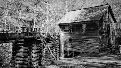
For 50 years, nearby farmers brought their corn and wheat to Mingus Mill, built in 1886. The miller usually charged a toll of one-eighth of the grain the customer brought for milling. The gristmill's stone was turned by a water-powered, cast-iron turbine. From water pressure built up in the penstock at the flume's end, the turbine generated 11 horsepower, enough to run all the mill's machinery. On the second floor, the smut machine blew wheat grain free of debris, while the bolting chest separated ground wheat into grades by sifting it through fine to coarse bolts of cloth.

Mingus was the largest gristmill in the Smokies. Its 200-foot-long wooden flume brings water to the mill's turbine. As early as the 1820's, more progressive millers began using turbines to power their mills rather than waterwheels. The Mingus family sold the mill to the National Park Service in the 1930's.


Continuing the scenic drive west on US-74, we headed for Juney Whank Falls and our next geocache (GCMBAZ). This puzzle cache requires gathering information along the 4.4 mile Deep Creek - Indian Creek loop trail. However once we arrived at the trailhead we weren't up for a long hike. So we just took the short hike to the first of several waterfalls for some photos.


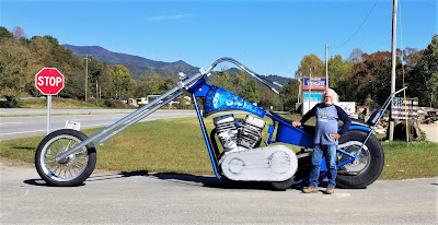
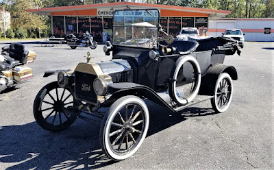
Here's one of those reasons why I like driving the backroads and byways through rural towns and communities across this great country. Passing by Cherokee County Cycles, I spotted this HUGE Harley-Davidson custom motorcycle along with a couple of other cool vehicles in the parking lot. I just had to pull in and get a few pics!


Crossing over into Tennessee, we check out the Great Copper Basin Earthcache (GCNP87) and a new caching county of Polk County. In 1843, a prospector, hoping to find gold south of the Coker Creek mine fields, instead located one of America's richest copper reserves. Over the next century, American and foreign companies chartered more than a dozen copper mines in the Ducktown Basin. The last mines closed in 1987. Many of the buildings still remain today.


We ended our day in Chattanooga at the National Cemetery for two virtual geocaches (GC5148, GC4E66). On Dec. 25, 1863, Maj. Gen. George H. Thomas, “The Rock of Chickamauga," issued General Orders No. 296 creating a national cemetery in commemoration of the Battles of Chattanooga, Nov. 23-27, 1863. Gen. Thomas selected the cemetery site during the assault of his troops that carried Missionary Ridge and brought the campaign to an end. The site Thomas selected was approximately 75 acres of a round hill rising with a uniform slope to a height of 100 feet; it faced Missionary Ridge on one side and Lookout Mountain on the other. Gen. Grant established his headquarters on the summit of the hill during the early phase of the four-day battle for Lookout Mountain.


By 1870, more than 12,800 interments were complete: 8,685 known and 4,189 unknown. The dead included men who fell at the battles of Chickamauga, Missionary Ridge and Lookout Mountain. There were also a number of reinterments from the surrounding area, including Athens, Charleston and locations along the line of Gen. Sherman’s march to Atlanta. A large number of men—1,798 remains—who died at the Battle of Chickamauga were relegated to unknowns during the reinterment process. In addition to Civil War veterans, there are 78 German prisoners of war buried here.

The Andrews Raiders Monument, erected by the state of Ohio in 1890, is among the most unique memorials in the cemetery. The granite base and die is topped with a bronze replica of “The General,” the Civil War-era wood-burning locomotive famous for its great chase of 1862.


Today, the Chattanooga National Cemetery encompasses just over 120 acres and nearly 60,000 permanent residents.

After 300 miles of driving, it was time to call it a night. Tomorrow is another day with new adventures and things to see. I hope you have enjoyed today's journey and will return for many more...

To follow along on our travels and keep up with my latest blogs, you may do so here of course. But also by using you favorite of these social media platforms: FacebookMeWeGabRedditParlorTwitterRVillageGETTR and Instagram. These all link directly to my profile. Again, please feel free to comment and / or share.

Saturday, August 28, 2021

2019-12-28: Spending the Day in Big Bend National Park

It's been 13 years since I was last here at Big Bend National Park in West Texas. Spending the last few years just a few hours north of here, I figured it was about time I paid another visit. We spent two nights in Alpine, TX as our base so we could get here early, stay all day, and not have a long drive home afterwards. Big Bend NP is over 1200 square miles and that's a lot to explore and see. So let's get going!


We arrived just after dawn to a cloudy morning which kinda hindered having some great sunrise photos. Our first geocache was an earthcache called "Fins of Fire" (GC3AZVV) facing the Chisos Mountains to the east, describing the layers and spikes and the creation of the mountains from volcanic activity.


Continuing the beautiful route down the Ross Maxwell Scenic Drive, we arrived at the Solol Vista Overlook and another earthcache (GC2NJRH). The amazing views here are awe inspiring. And from this vantage point we barely get a glimpse of our destination Santa Elena Canyon some fourteen miles in the distance. From here though it's just a tiny notch in the mesa across the valley.


In the panoramic photo below taken from the Sotol Overlook, from left to right are: Trap Mountain, Goat Mountain, Santa Elena Canyon, Kit Mountain, across the valley to Tule Mountain, Burro Mesa, Little Christmas Mountain, and Christmas Mountain.


After the overlook, we stopped at Tuff Canyon for another earthcache (GC72D1C). Tuff Canyon is the deepest of the dry washes in Big Bend NP. This also makes it very dangerous during or after a rain as the gathering waters pick up velocity and can cause a flash flood rushing between the canyon walls. Over time the rushing waters slowly dig a deeper channel while at the same time eroding and smoothing the layered rock walls.


The mountains and cliff walls are plentiful. Just driving the roads, you won't even need to get out of your car to be amazed at the views.


Now we get to the Santa Elena Canyon observation area (GC37ECH). The Santa Elena Canyon is one of the most famous landmarks within Big Bend National Park. Looking from the overlook area, that's the United States on the right, Mexico on the left, and the shallow Rio Grande River flowing up through the middle and curving to the left. A lot of people stop there to get their photos. However if you keep following the road around, it will take you down to the entrance, or should I say the exit.


Where the Rio Grande exits the canyon, there's the Santa Elena Canyon Trailhead. The Terlingua Creek drains into the Rio Grande River just as it exits the canyon. You can see it in the next photo coming in from the left. Most of the time the water level is low enough and you can easily walk across rocks without getting wet. Once you cross over and climb the short hill you enter the trailhead that has been paved creating an easy hike with stairs and switchbacks up 160 feet to the point from which I took the photo.


Once you make the short hike up and over at the trailhead, you make your way down the trail into the cool canyon. Because of the 1500 feet canyon walls that seem to raise up forever, they block out the sun except for the short time it is directly overhead. We continued our hike down and back to see how far we could go. Officially it's a 1.5 mile out and back hiking trail.


At this point, we came to the end of the trail. This is about as far as you can hike without getting wet. Now I was wanting a kayak so I could keep going to see what's around the corner. One of these days I just might do that.


Backing up a little ways there's this huge rock that had fallen near the edge of the bank of the Rio Grande. I talked Candy into climbing out on the rock with me and handed my phone to another hiker to take our photo. I think this turned out much better than trying to take a selfie and still get the full canyon effect.


Having made our way back in the GeoJeep, it was time to hit some of the offroad trails. First we drove back up the Ross Maxwell Scenic Drive and looped around over to the Panther Junction Visitors Center. This time we finally bought one of those National Park Passport books that you get stamped each time you visit a national park or historical site.

From there we made our way down to Glenn Springs Road. It's a gravel road that even a regular car can make it through, see the first pic at the top of the blog. There might be some parts that may be a little rough, but I'd drive down most of it if I still had the Prius and the turn around if I got to an impassible section.

After several miles it turns into Black Gap Road as it nears the spring. There it does become a rougher section that really requires high clearance vehicle. Just past the Glenn Spring primitive campsite I found my next virtual geocache (GCR2A8). The U.S. Calvary once used this location for a few years. If you look hard enough you can still find parts of the foundations of some of the buildings. At the top of the nearby hill you'll find some scattered wooden crosses for the cemetery. To get credit for finding the virtual cache you need to email the number of crosses. The Find-A-Grave website only lists five memorials here. If you use that number you won't have the correct number as there are more than that. And not having any names on the wooden crosses, they are known only to God.


Another hour or so of offroad fun in the GeoJeep and we make our way to the exit roads and back up to Alpine, Texas. It wasn't until later that I realized the Black Gap Road was one of the trails in the Jeep Badge of Honor series. If I had used the BoH app to check in from the trail, I could have gotten my first badge. Oh well, I guess that's a good excuse to have to come back and explore some more of the Big Bend National Park. There is still much to see out here that I haven't gotten to yet. And I recommend this place to be put on your bucket list one day. Just try to avoid summer as the temps are easily in the triple digits!

To follow along on our travels and keep up with my latest blogs, you may do so here of course. But also by using you favorite of these social media platforms: FacebookMeWeGabRedditParlorTwitter, and Instagram. These all link directly to my profile. Again, please feel free to comment and / or share.

Saturday, August 14, 2021

2019-11-25: Our Return to Hiking the Lighthouse Trail in Palo Duro Canyon Texas

Welcome back friends, family, geocachers, RV'ers, Jeepers, and everyone else who just happened to drop by my AwayWeGo's Geocaching Adventures blog. This is more about just geocaching though. I'm here to share my travels around this great country. The geocaching just helps me find some of those out-of-the-way very rural backroads "not-on-your-tourist-map" great sightseeing treasures.

If you'd like to follow along via many of the social media sites. I'll provide links at the end of this blog. I'd also love to hear from you, so please feel free to comment here or on the social sites. And please by all means share my stories with your friends too. I hope my stories inspire you to get out and explore.


Well after my opening paragraph, today we DID do the touristy thing and return to the Palo Duro Canyon. We both had this Thanksgiving week off so we decided to take a drive up to Amarillo, Texas and do some hiking in the Canyon. We were here a few years earlier to make this hike and that's where I proposed to her. (see "She Said Yes!") We've been married now for just over three years.

Plus along the hiking trail up to the famous rock formation called The Lighthouse, there was a trail of geocaches hidden. Many of those caches had been missing and we had to DNF them. They've since been replaced and now we can redeem those DNF's.


The weather couldn't have been better! It was cool out and with sunny skies, it made for perfect hiking. It also made for some pretty good photos I think. This next photo I call Sitting Chief. I don't know if it has an official name, but that's what I think of every time I see it.


Some background info from the Palo Duro website: The history of the canyon goes back a long ways. The Clovis and Folsom peoples first lived in the canyon and hunted large herds of mammoths and giant bison. More recently, the Apache, Comanche, and Kiowa took advantage of the canyon's plentiful resources. These early cultures left behind rock art and bedrock mortars where they ground mesquite beans and roots for food. The early Spanish explorers probably discovered the canyon and called it Palo Duro, Spanish for Hard Wood.

The Red River War between the U.S. Army and southern Plains Indians lasted from June 1874 to the spring of 1875. A decisive battle occurred in the canyon on Sept. 28, 1874. Colonel Ranald S. Mackenzie led the 4th U.S. Cavalry in a surprise attack at dawn on a camp of Comanches, Kiowas and Cheyennes. The families fled up the canyon, leaving everything behind. MacKenzie’s troops captured 1,400 ponies and shot most of them. Soldiers also burned all the teepees and winter stores. With no horses or supplies, the families had no choice but to return to the reservation. The reign of Native Americans over the Panhandle plains ended soon after.


Charles Goodnight, a former Texas Ranger, drove 1,600 Longhorn cattle to Palo Duro Canyon in 1876. He and his partner John Adair, an English aristocrat, founded the JA Ranch in 1877. At its peak in 1885, the ranch grazed 100,000 head of cattle on 1,325,000 acres spread across the Panhandle. After Adair died, his widow, Cornelia, took over as Goodnight’s partner. In 1887, Goodnight decided to scale back his ranching activities. The partnership ended that year, and the partners divided the land. Most of the canyon belonged to the JA Ranch up until 1890. Adair descendants continue to run the JA Ranch today.

The state bought the land for the park from Fred S. Emory in 1933. Soon after, Civilian Conservation Corps workers arrived, and spent the next five years creating a park. First, they built a camp for their home base, and then they set to work in the immense canyon. The men built the winding road to the canyon floor. Until it was finished, they hiked in and out of the canyon on what is now the CCC Trail. CCC workers made all of the park’s original improvements, including El Coronado Lodge (now the Visitor Center), the cabins on the rim and canyon floor, and trails. Designers planned the park to maximize views and complement the surroundings. The CCC used local stone and wood for building materials. In addition, workers forged decorative metal and crafted furniture. The park opened in 1934 before it was complete. It is the second largest park in the state parks system today, with about 28,000 acres


So of the 6 or 8 remaining caches along the trail that we needed to find, we only DNF'd just one... again. Since our last visit there was added a virtual geocache (GC7B6H7) and an earthcache (GC81YE8) up at Lighthouse Point. Upon arriving, we did the obligatory oohs and aahs, took in the views and captured some photos. Then after a short time we hunted for the answers for the caches before descending down into the canyon for our hike back to the parking lot. It is a beautiful Texas State Park and one of my favorite places in the country. I'm sure we will be returning again often.


I hope you have enjoyed our visit today to Palo Duro Canyon up in the panhandle of Texas. To follow along on our travels and keep up with my latest blogs, you may do so here of course. But also by using you favorite of these social media platforms: Facebook, MeWe, Gab, Reddit, Parlor, Twitter, and Instagram. These all link directly to my profile. Again, please feel free to comment and / or share. Until next time... see you out on the road!

Saturday, March 13, 2021

2019-05-26: Roadtrip Day2! The North Carolina County Challenge: Visiting Mt Pilot, Siamese Twins, the Jail Chapel, and the Blue Ridge Parkway

Rise and shine roadtrippers, geocachers, travelers, and friends. Today is Day 2 of our 3-day Memorial Day weekend roadtrip across North Carolina. (Click here for Day 1) We gotta lot of miles west into the mountains to get to today. And hopefully round the corner back east to start the return trip for tomorrow. So grab a cup of coffee, climb into the GeoJeep and let's get going...

I grab breakfast in the lobby and check out of the hotel at the crack of dawn. Before driving away, I first grab the geocache (GCW6C1) in the parking lot to claim a find for Forsyth County. It wasn't a planned cache, but when there's a geocache so close it's hard to just leave it behind.

Driving west into Yadkin County, I pass through East Bend headed for the Mt Olympus Greek Restaurant for my next geocache (GC42WQF). What should have been a quick parking lot find turned into 15 minutes spent for a DNF. Being half Greek, I really wanted to find this one. But no luck this morning. I still need the county so I drive another mile down the road for another quick roadside cache and find that one (GC3YNZM).

On the way to my next geocache, driving the backroads through the country, I spot this old truck sitting off to the side of this gated driveway. Then I notice the skeleton sitting inside and just knew I had to turn around for a photo. As I'm taking the photo, I see the sign and realized that I'm getting my picture taken also.


Driving north on US-52 into Surry County, I see my next goal. As a fan of "The Andy Griffith Show" I wanted to return to Pilot Mountain, also known as Mt Pilot on the TV show. It's been nearly 14 years since I last visited this area with my sons and I hadn't yet started geocaching. There were two geocaches: "This Way to Pilot Mountain" (GC322YP) near the state park entrance and the "Pilot Mountain" Earthcache (GC1195C) up near the observation deck. I drove up the mountain to the parking area and made the short hike to the observation deck. After some photos I gathered the information I needed to claim a find for the earthcache.

Driving up US-52 with a view of Pilot Mountain

The view from the observation deck.

The view from the observation deck.

I wouldn't want to be down below if that rock slides off!

Instead of continuing on up to Mayberry (Mt Airy), since I've been there before, I thought I would check out less popular historical sites. Such as a virtual geocache at the grave of the Bunker Brothers (GCF338). I know... you're probably thinking "Who are the Bunker Brothers?" More commonly known as the Siamese Twins, Chang and Eng were born in 1811 in what used to be called Siam, now Thailand.

In 1829, the twins left Siam to begin touring Europe and the US. They were very popular and drew large crowds in "freak shows" where the twins exhibited various feats of strength and dexterity. In 1839 the brothers quit touring, purchased 150 acres in Traphill, became American citizens and choose the last name of Bunker in honor of a woman they met and admired in New York. In 1845 they purchased 650 acres here in Surry County. A few years later the twins married two sisters, Sallie and Adelaide Yates


Within 9 months and one week of the marriage each sister had given birth to a child. Over the years 19 more children would be born to the sisters. Over time, the two sisters began to fight and would often put Chang and Eng in the middle of their fights. It was decided that the family would split and two houses were built. The two houses were about two miles apart and the twins would spend three days in one house with Sallie and then move in with Adelaide for three days before starting the cycle all over.

Chang passed away on Jan 17, 1874. There were several theories and autopsies performed as to why Eng died, some saying within 30 minutes and others up to two hours. It is often said that Eng was scared to death of the thoughts of his brother being dead and have attributed his death to shock. Others concluding that blood continued transferring from Eng to Chang, but obviously not returning. They were then buried in the lawn at Chang’s house and in the 1920’s were moved to the church that they are at now, which the brothers had donated the land for.


The White Plains Baptist Church was established in 1856 on land donated by Chang and Eng who went to church there. The twins, their wives, and 40 other Bunker's are buried there in the cemetery, plus many other descendants under various other names.

One more geocache for Surry County was at the Dix Freeman Homeplace (GC4P3ER), a favorite location for Round Peak musicians to gather to play their old-time music and hold weekly square dances. Furniture would be moved, sometimes even outdoors, to make room for two or more groups of square dancers in the two room cabin. String musicians, mostly fiddle and banjo players, would stand in the doorways and play their music for the dancers.

“Breaking up Christmas,” usually held after harvest time between Christmas and the New Year, was a time for festivities including music, dancing, socializing and lots and lots of food! Families in this Round Peak area would begin at the Freeman home and then travel to a different cabin every night. Dix Freeman, 1908 – 1995, was an oldtime claw-hammer banjo player who learned to play when he was 10 years old. He credits learning most of his banjo tunes from the legendary Charlie Lowe. Dix played with the Pine Ridge Boys and was a collector of banjos and fiddles, amassing over 237 instruments.

Round Peak Mountain, eleven miles east of here, lends its name to the signature style of old-time fiddle and banjo music that developed in its shadow. The relative isolation of the community and difficulty of travel during most of its history helped to ensure that a limited selection of songs shared and composed by residents would eventually became the core of today’s “Round Peak” music. Round Peak music is characterized by a close interplay between the fiddle and the “fretless” banjo with a driving sound that developed as the musicians played for flat foot and square dancers at frequent social gatherings such as corn shuckings, barn raisings, house parties, and an annual local party tradition referred to as "Breaking Up Christmas."


Moving right along and hopefully picking up the pace. I found a quick roadside geocache in Alleghany County (GC2RTZF) before getting onto the Blue Ridge Parkway. Then quick earthcaches at the Stone Mountain Overlook (GC77NWW) and the Air Bellows Gap Overlook (GC6TP4K).


One more stop further down the parkway exiting at mile marker 248 was for a cache (GC47JGV) at this Jail / Wedding Chapel in Laurel Springs. Gives new meaning to the term "shotgun wedding" I suppose. Doing a little research, I found that that wasn't ever a real jail or chapel. Just painted up that way for a roadside attraction and photo opp. Unfortunately it was a busy area off the parkway with a restaurant and bar across the street and a motel and campground nearby. There were a lot of muggles nearby and made it difficult to search for the cache.


Driving down to Glendale Springs in Ashe County, I stop for a multi-cache. A multi-cache is where you have to go to multiple stages getting clues to the final coordinates. They can be as few as a simple 2-stage cache to as many as you want. I think the longest I've found was a 7- or 8-stage multi-cache.

This one was called "Re-Visit the Past" (GCK8FB). In the late 1800’s Episcopal missionaries came to this region of the Blue Ridge Mountains to provide schooling and medical help for the people living there. Holy Trinity Episcopal Church was built in Glendale Springs in 1901. After the church was officially closed in 1946, members began removing the furnishings and taking them home. For over 30 years the church sat deserted and neglected. In 1972, Rev. Faulton Hodge became priest-in-charge at St. Mary’s Episcopal Church in nearby West Jefferson. In the late 1970’s, he started a campaign to restore Holy Trinity. As work progressed on the building, the original furnishings were returned. Today the church has its original pews, pump organ, Altar, and candle stands.

There's also a cemetery on the property as well that has over 200 interments and is still in use today. According to the findagrave website, the oldest dates back to 1879. After gathering clues from the front and cemetery area, The final cache location was around back by this large statue.


Then there is the "Fast Find" cache (GC5QYT7) in Watauga County followed by another quick roadside stop at "Fall Creek" guardrail cache (GC29P3N) in Wilkes County. Had to take a few pictures at the creek though.


Getting back to the Blue Ridge Parkway southbound, I stop at the Green Mountain Overlook for another earthcache (GC6YHXZ) in Caldwell County and a few photos. I decided to include the GeoJeep in one of them.


Moving down into Avery County there was the Boulderdash Earthcache (GC700KY)...


...followed just down the road by the Artic Window Peak earthcache (GC21N6F) at the Yonahlossee Overlook.


My next stop was down in McDowell County at a cache called Restful River (GC6KHW5). This cache was near the bridge overpass for the North Fork Catawba River and the Honeycutt Creek. Down along the banks were a dozen or more of these butterflies. Every now and then they'd stop long enough for me to get a photo.


And then there's the "Be In Three Places At Once" cache (GC6HE12). Louise's Rock House Restaurant was formerly known as the Linville Falls Tavern and is on the National Register of Historic Places. Built in 1936 by stone mason Lenoir Franklin and owned by C.J. Howell, the tavern was built right where the intersection of three counties converge. The Avery, Burke, and McDowell counties all come together near the fireplace. With the layout of the restaurant, your food is cooked in Avery County, picked up by the wait staff in Burke County, and then served to you in McDowell County. Even though the restaurant was a little busy, the cache was hidden enough by the wall that I was able to quickly retrieve it without being seen. I just forgot to take photos.

Well it was starting to get late in the day. Looks like I'm gonna have to skip a few of the counties still to west and round the corner back towards Blounts Bay. So I head south into Rutherford County and the town of Forest City. There I get a quick parking lot cache (GC4H1H9) to claim that county. Now driving on US-74 eastbound, another quick parking lot cache in Cleveland County (GC16C21). Turning north on US-321 for a park and grab in Lincoln County (GC53CBQ).

Saturday, January 9, 2021

2019-04-20: Geocaching, Hiking, and Exploring the Beautiful Wichita Mountains Wildlife Refuge in Oklahoma

For today's adventure, we are once again Away-WE-Go for this Easter holiday weekend. Most of these blog posts I'm usually by myself on my Sunday drive back to work. Having this long weekend off, we decided to take a drive up to Oklahoma.


If you recall last month on my long roadtrip back from Minnesota, I had stopped at the Wichita Mountains Wildlife Refuge. I mentioned that they perform a live Passion Play every Easter and have been doing it for nearly 80 years. You can read more about that by revisiting my blog page here. Candy and I thought it would be a great idea to go and see it. So we drove up yesterday.

The granite walls of the Wichita Mountains offered refuge to waves of people over many centuries, beginning with Nomadic Native Americans. In the late 1800's, conservationists made plans to re-establish bison and other imperiled species in the region. Looking for the best habitat, they decided that the sheltered prairie of the Wichita Mountains was the ideal location.

This morning we came here to see more of the natural refuge, do some hiking, and hopefully see some wildlife. For our first stop we drove over to French Lake and parked by the Bison Trail for a hike over to the dam. The many dams located in this refuge which form all the lakes were constructed in the 1930's as park of the Federal Work Projects. We hiked the Elk Trail back to the GeoJeep. It was a pleasant, clear, perfect weather morning. Got some nice views of the lake and the dam. The only wildlife we saw was a bunch of turtles and some fish in the lake.


From there we drove south on Indiahoma Road down to our first geocache. The "Heart Rock Earthcache" (GC3AQ2J) is a large outcrop of lava rock forced up from below the surface. Many, many years of erosion created this heart shaped rock on a pedestal that's about chest high when standing next to it. If it wasn't at such an angle, it'd make a great picnic table. While there is a pull-off parking area for the scenic views, there's no mention of this heart rock formation. Just another reason why I like geocaching to find the unique roadside attractions.


Just as we got back to the GeoJeep, we were just in time to see a parade of more than a dozen old tractors going by. Now I'm not really into tractors but seeing some antique machinery being driven down the road was pretty cool.


Back up on State Road 49 through the middle of the Refuge, we come upon Prairie Dog Town. A field of hundreds of prairie dogs running around and popping up and down from their underground city. I wish I had my Nikon camera with me but I left it back in Texas. So I only have this fuzzy phone photo. Takes good pics normally, but not so good when you zoom in close.


Next we drive over to the southside of Quanah Parker Lake to the Little Baldy Trailhead. Crossing the Quanah Creek Dam which forms the lake, we begin hiking the Little Baldy Trail. Little Baldy is one of the rocky hills within the refuge. We hiked up to the top of for the views and for the Little Baldy virtual geocache (GC1E4D).


Returning to the GeoJeep and continuing down the road a few miles we finally saw some bison. So we pulled over, took some photos, and watched for a while.


It was now mid-afternoon and we didn't plan very well. We're now out of water and hungry because we didn't think about bringing snacks or food. We stopped by the Holy City of the Wichitas for a quick look to see what of the situation. People were already gathering and picking out their spots to watch the Passion Play which was still 10 hours away from starting. Candy got a quick look around at the buildings. They had bottled water but nothing to eat. So we needed to go back into Lawton to eat and return later.

As we were driving out we stopped at this structure. Completed in 1927, Benjamin Ferguson and his family lived in this house until 1942. About a half mile to the east is the Ingram Homestead. They were both built out of the round granite core stones that cover the hillsides of the refuge, and both were acquired during the 1901 land lottery held at Fort Sill. They reflect the hard work, ingenuity, and craftmanship of earlier generations.

In 1942, the U.S. Army used the right of eminent domain to acquire the homesteads to expand the artillery range of the adjacent Fort Sill. Fifteen years later the planned expansion was scrapped and the homesteads became a part of the Refuge. In 1981 they were added to the National Register of Historic Places.


After grabbing some dinner and now back at the hotel to freshen up after all the hiking today, we were too exhausted to drive back to the Refuge to sit and wait for the play to start. But now that we have a better understanding of what it would be like, we're better prepared to come back again. Though next time we'll have folding chairs, a cooler with drinks, and plenty of food.

Still a great day of hiking and exploring the Wichita Mountains Wildlife Refuge. Come back tomorrow for the roadtrip home. I've got a few interesting places on the agenda for the roadtrip home. See you then...